
Absolutely, Boston boasts one of the oldest and most extensive subway systems in the United States, colloquially known to locals and visitors alike as “the T.” For anyone planning to explore this historic city, understanding and utilizing its public transportation network is not merely a convenience but an essential component of an authentic Boston experience. Far from being a mere functional utility, the T is woven into the fabric of Boston’s identity, offering a reliable, cost-effective, and often picturesque way to traverse its vibrant neighborhoods and reach its myriad attractions.
The question of whether Boston has a subway system is quickly answered with a resounding yes, but delving deeper into its operational nuances, historical significance, and practical applications for travelers reveals a fascinating and efficient urban transit solution. This guide will provide an insightful overview, transforming a potential point of confusion for first-time visitors into a clear roadmap for seamless exploration. From its storied past to its modern-day functionality, the T serves as the lifeblood of Boston, connecting iconic landmarks, bustling commercial districts, and serene residential areas. For tourists, navigating the city without the T would be akin to missing a crucial beat of its urban rhythm, making it an indispensable tool for an enriching travel experience.
The Massachusetts Bay Transportation Authority (MBTA) and Boston’s “T”
The formal name for Boston’s public transit operator is the Massachusetts Bay Transportation Authority, or MBTA. However, the subway system itself is affectionately referred to by everyone simply as “the T.” This moniker stems from the distinctive ‘T’ logo that marks all subway stations, a symbol recognized throughout the region. The MBTA oversees not only the subway but also a comprehensive network of buses, commuter rail lines, and ferry services, creating an integrated transit system that serves Boston and its surrounding communities. For travelers, focusing on the subway component, the “T,” is usually the primary concern for getting around the city’s core.
A Rich History of Urban Transit
Boston’s subway system holds the distinction of being the first in the United States. The initial section, known as the Tremont Street Subway, opened on September 1, 1897, revolutionizing urban transportation and setting a precedent for cities across the nation. This pioneering infrastructure was designed to alleviate severe traffic congestion in Boston’s narrow, winding streets, many of which date back to colonial times. Over the decades, the system expanded, adapting to the city’s growth and evolving needs. From the original underground streetcar lines, it grew to incorporate heavy rail and distinct color-coded routes, reflecting a continuous commitment to connecting Boston’s diverse neighborhoods. The history of the T is a testament to Boston’s innovative spirit, showcasing how the city has consistently sought to balance its historic charm with modern functionality.
Understanding the “T” Colors and Lines
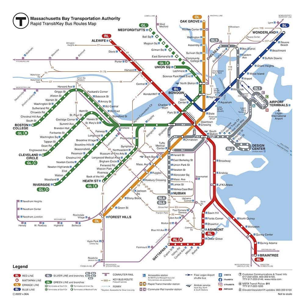
The “T” system is characterized by its five distinct subway lines, each identified by a specific color, making navigation intuitive for both residents and visitors. These lines are:
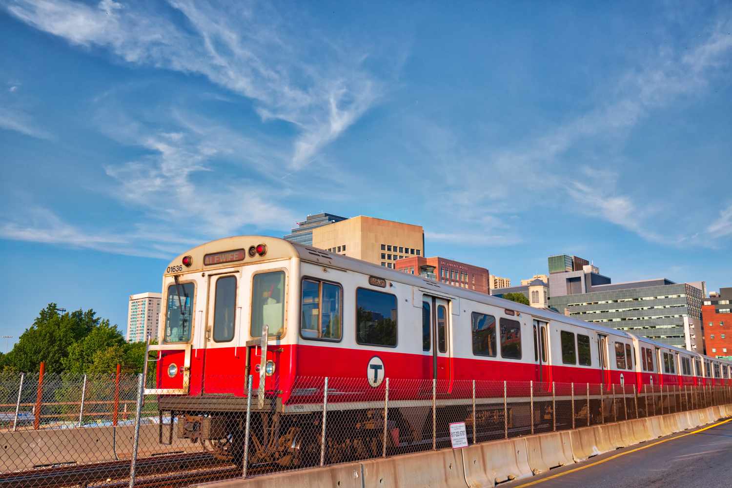
- Red Line: Running primarily north-south, connecting Cambridge (including Harvard University and MIT) with downtown Boston and extending south to Braintree and Ashmont.
- Orange Line: Another crucial north-south route, providing service from Malden through downtown Boston and continuing to Forest Hills in Jamaica Plain. It’s especially useful for accessing areas like North Station and South Station.
- Blue Line: Primarily serving east-west, connecting Logan International Airport and the harbor islands with downtown Boston and extending further north to Revere.
- Green Line: This is Boston’s light rail or streetcar system, and it is the most complex, splitting into four distinct branches (B, C, D, E) after departing Park Street station. It’s essential for reaching areas like Fenway Park, the Museum of Fine Arts, the Longwood Medical Area, and various Boston University and Boston College campuses.
- Silver Line: A bus rapid transit (BRT) service that operates both above and below ground, connecting Logan International Airport to South Station and extending into the Seaport District.
Understanding these color codes and their general directions is the first step to mastering Boston’s public transit. Stations are clearly marked with the ‘T’ logo and the line colors they serve.
Navigating the “T”: A Traveler’s Guide
For travelers, using the T is surprisingly straightforward once a few key elements are understood. The system is designed to be accessible, though peak hours can be crowded, and some stations, particularly older ones, may have limited accessibility features.
Acquiring Your CharlieCard or CharlieTicket
To ride the T, you’ll need a fare card. The two main options are:
- CharlieCard: This is a reusable, plastic card similar to those used in many major transit systems. It offers the lowest fares and can be loaded with cash value or multi-day passes. CharlieCards can be obtained from subway station vending machines or the MBTA retail store. It’s ideal for those staying for several days or planning to use the T extensively.
- CharlieTicket: A paper ticket with a magnetic stripe. While slightly more expensive per ride than a CharlieCard, it’s convenient for single rides or short visits. CharlieTickets can be purchased from vending machines at all subway stations.
For most tourists, especially those planning to use the T for more than a couple of days, acquiring a CharlieCard and loading it with a multi-day pass (e.g., 7-Day Pass) is often the most economical and hassle-free option.
Fares, Transfers, and Cost-Saving Tips
Single subway fares are fixed, regardless of distance traveled within the subway network. Bus fares are slightly lower. When using a CharlieCard, transfers between subway lines are free, and transfers from subway to local bus within a certain timeframe are also free. This interconnectedness is a significant advantage, allowing travelers to reach virtually any point in the city with a single fare.
- Day and Multi-Day Passes: The MBTA offers 1-day, 7-day, and monthly passes. For tourists, the 7-day pass, in particular, offers unlimited rides on subway and local bus services, providing excellent value if you plan frequent travel.
- Commuter Rail Fares: Note that the commuter rail, which extends far into the suburbs, operates on a zone-based fare system separate from the subway. If your travel plans involve venturing far outside the city center, check commuter rail specific fares.
Accessibility and Station Navigation
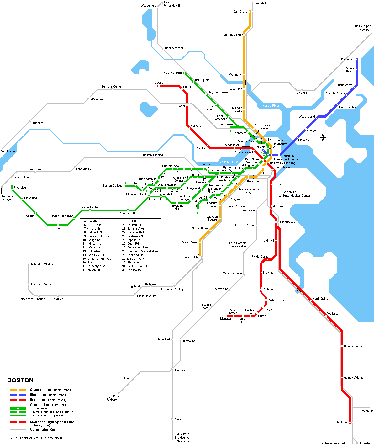
While the MBTA has made significant strides in improving accessibility, some older stations may still pose challenges for individuals with mobility impairments. Many major stations are equipped with elevators and ramps, but it’s advisable to check the MBTA’s website for up-to-date accessibility information on specific stations if this is a concern. Maps are readily available at stations and online, clearly showing all lines, stations, and transfer points. Digital apps and real-time tracking can also aid navigation, providing live updates on train arrivals and potential delays.
Exploring Boston by Subway: Key Destinations and Connections
The T is your ultimate gateway to Boston’s most celebrated attractions, historic sites, and vibrant neighborhoods. Its reach ensures that you can minimize walking distances and maximize your sightseeing efficiency.
Reaching Iconic Boston Landmarks
- Freedom Trail: Many points along the Freedom Trail, such as Boston Common, Faneuil Hall, and the Old North Church, are easily accessible via the Green Line (Park Street, Government Center, Haymarket stations) and the Blue Line (Aquarium).
- Fenway Park: Home of the Boston Red Sox, Fenway Park is conveniently located near the Kenmore station on the Green Line (B, C, D branches).
- Museum of Fine Arts & Isabella Stewart Gardner Museum: Both world-class museums are a short walk from the Green Line’s Museum of Fine Arts stop (E branch).
- Harvard University & Cambridge: The Red Line directly serves Harvard Square and Kendall Square/MIT, making it simple to explore these academic and technological hubs across the Charles River.
- Newbury Street & Back Bay: The upscale shopping and dining of Newbury Street are best reached via the Green Line (Copley or Arlington stations).
- TD Garden: For sports and concert events, the TD Garden is situated atop North Station, accessible via the Green and Orange Lines.
Connecting to Logan International Airport
One of the most valuable aspects of the T for travelers is its direct connection to Logan International Airport. The Silver Line (SL1) offers free service from all airport terminals directly to South Station, a major hub for the Red and Commuter Rail lines. Alternatively, the Blue Line is also easily accessible from the airport via a free shuttle bus service connecting terminals to the Airport subway station. These connections make traveling to and from Logan efficient and cost-effective, bypassing expensive taxi or ride-share fees.
Beyond the City Center: Commuter Rail Connections
While the subway focuses on urban and inner-suburban travel, Boston’s Commuter Rail network extends the MBTA’s reach much further into Massachusetts. With major hubs at North Station and South Station, the Commuter Rail allows travelers to explore charming towns outside of Boston’s immediate vicinity, such as Salem (famous for its witch trials history) or the scenic coastal towns. These longer-distance trains require separate tickets but are seamlessly integrated with the subway at their respective central stations.
Benefits and Challenges of Using the “T”
Like any major urban transit system, the T offers numerous advantages for visitors but also comes with certain considerations.
Advantages for Visitors
- Cost-Effectiveness: Compared to taxis or ride-shares, especially during peak traffic, the T is significantly cheaper, allowing travelers to save their budget for attractions and dining.
- Efficiency: Despite occasional delays, the T often beats surface traffic, particularly during rush hours, ensuring quicker transit between destinations.
- Environmental Friendliness: Utilizing public transport is a sustainable choice, reducing carbon footprint compared to private vehicle use.
- Authentic Local Experience: Riding the T offers a glimpse into daily Boston life, providing an authentic local experience that driving cannot replicate.
- Convenience: Many of Boston’s key attractions and neighborhoods are directly served by subway stations, minimizing walking.
Peak Hours and Service Considerations
The main challenge with the T, particularly for those accustomed to less crowded systems, is the congestion during peak commuting hours (typically 7-9 AM and 4-6 PM on weekdays). Trains can be packed, and delays can occur, especially on the Green Line due to its surface-level sections. Weekend schedules may also differ, and planned maintenance often takes place during off-peak hours or weekends, sometimes leading to shuttle bus replacements for sections of a line. It’s always wise to check the MBTA website or a transit app for real-time updates before embarking on a journey.
Tips for a Seamless Boston Subway Experience
To ensure your experience with the T is as smooth and enjoyable as possible, consider these practical tips.
Safety and Awareness
Like any urban transit system, practicing general safety and awareness is prudent. Keep an eye on your belongings, especially in crowded stations or trains. While Boston’s T is generally safe, being mindful of your surroundings, particularly late at night, is always recommended. Utilize well-lit stations and platforms.
Real-Time Information and Apps
The MBTA provides real-time tracking for all its services, which is invaluable for planning. Download a reputable transit app (many free options are available that use MBTA data, such as Citymapper or Google Maps) that can offer live train locations, estimated arrival times, and delay alerts. This will help you navigate unexpected service changes and minimize waiting times. Having a digital map of the system readily available on your phone is also a great backup.
In conclusion, Boston not only has a subway system but an incredibly rich and functional one that stands as a cornerstone of its urban landscape. The “T” is an indispensable tool for any traveler seeking to immerse themselves in the city’s history, culture, and vibrant modern life. By understanding its lines, fares, and operational quirks, visitors can unlock the full potential of their Boston adventure, navigating the city with ease, efficiency, and an authentic sense of local exploration. Embrace the T, and Boston will truly open up before you.
LifeOutOfTheBox is a participant in the Amazon Services LLC Associates Program, an affiliate advertising program designed to provide a means for sites to earn advertising fees by advertising and linking to Amazon.com. Amazon, the Amazon logo, AmazonSupply, and the AmazonSupply logo are trademarks of Amazon.com, Inc. or its affiliates. As an Amazon Associate we earn affiliate commissions from qualifying purchases.