
The Sunshine State’s Unique Topography
Florida, often celebrated for its sun-drenched beaches and vibrant ecosystems, presents a topographic profile that sets it apart from much of the United States. Far from mountainous, the state is predominantly low-lying, characterized by vast expanses of flat terrain barely above the sea. This unique geographical feature is not merely a descriptive detail but a fundamental aspect that shapes its environment, ecology, and even the very character of its natural landmarks. Understanding Florida’s elevation is crucial to appreciating its sensitive ecosystems and its ongoing dynamic relationship with the surrounding Atlantic Ocean and Gulf of Mexico.
General Elevation and Key Figures
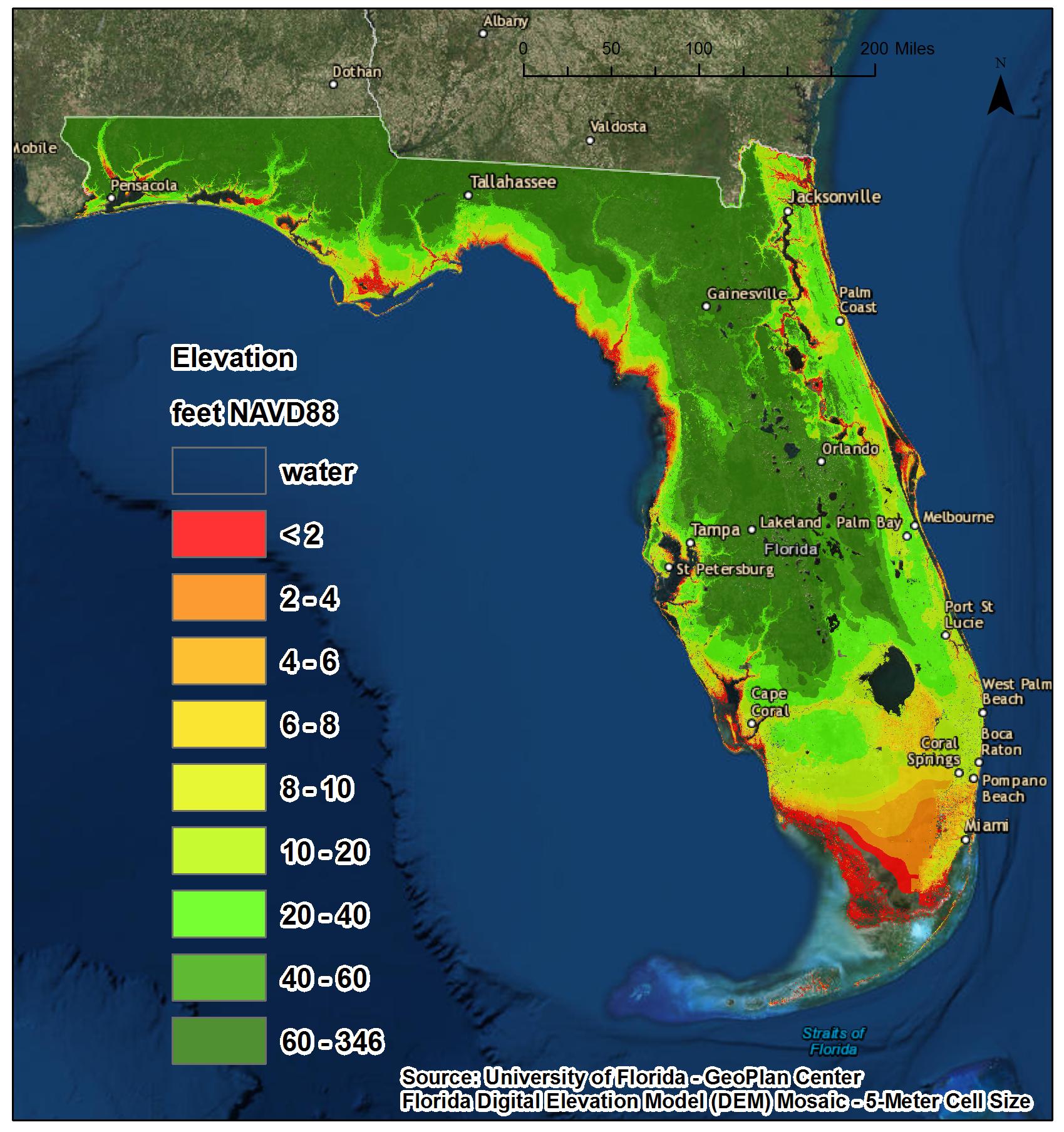
The average elevation of Florida is approximately 100 feet (30 meters) above sea level. However, this average masks significant variability, with much of the Florida Peninsula maintaining an elevation considerably lower, particularly along its extensive coastlines. Major urban centers like Miami and Fort Lauderdale in the southeast, and Tampa and St. Petersburg on the Gulf Coast, stand at elevations often less than 10-15 feet (3-4.5 meters). Even inland cities such as Orlando, while slightly higher, are still relatively flat compared to most other states. The Florida Keys, an archipelago off the southern coast, are essentially at sea level, composed of ancient coral reefs. This pervasive low elevation has profound implications for water management, urban planning, and the preservation of its natural heritage.
Florida’s Highest Point: Britton Hill
Despite its generally flat landscape, Florida does possess a highest point. Britton Hill, situated in the Florida Panhandle within Lakewood Park in Walton County, reaches a modest peak of 345 feet (105 meters) above sea level. This makes it the lowest state high point in the United States. Surrounded by rolling hills, which are themselves a rarity in the state, Britton Hill is more of a gentle rise than a towering summit. While it offers a symbolic contrast to the pervasive flatness, its relatively low elevation underscores the dominant geological characteristics that define the state as a whole: a low-lying landform deeply intertwined with the sea.
Geographic Factors Influencing Florida’s Low Elevation
The underlying geology of Florida is the primary determinant of its low elevation and distinctive landscape. The state is essentially a large, ancient platform composed predominantly of limestone, slowly built up over millions of years by marine deposits.
Karst Topography and Limestone Foundations
Below Florida’s surface lies a vast, porous bedrock of limestone. This soluble rock gives rise to karst topography, a landscape characterized by sinkholes, caves, and extensive underground drainage systems. Rainwater, slightly acidic, percolates through the surface and dissolves the limestone, creating voids and channels. This process prevents the formation of steep, elevated terrain and instead contributes to a relatively flat, permeable landmass. The prevalence of limestone also means that a significant portion of the state’s freshwater is stored in and moves through complex aquifer systems, making groundwater management a critical environmental concern.
The Role of the Florida Platform
Geologically, Florida is part of the Florida Platform, a stable piece of continental crust that extends outward into the Gulf of Mexico and the Atlantic Ocean. For much of its history, this platform has been submerged or partially submerged, allowing for the accumulation of marine sediments that eventually compacted into limestone. Fluctuations in global sea levels over geological timescales have repeatedly exposed and submerged parts of the platform, but its fundamental structure as a low-relief, carbonate-dominated landmass has remained consistent. This geological heritage explains the absence of dramatic mountain ranges or high plateaus that define other regions.
Coastal Plain Dynamics
Florida is largely a coastal plain, an area of flat, low-lying land adjacent to a coast. These plains are formed by the deposition of sediments carried by rivers and waves. Over time, these sediments build up, creating fertile but often poorly drained areas. The dynamics of wave action, currents, and sediment transport continue to shape Florida’s barrier islands, estuaries, and vast wetland systems, all of which are intrinsically linked to its low elevation. The subtle gradients across these plains dictate the flow of water, supporting a mosaic of habitats from pine flatwoods to freshwater marshes.
Ecological Implications of Low Elevation
The subtle elevation gradients of Florida are not a uniform blanket of flatness but a complex tapestry that supports a stunning array of biodiversity. Water, its movement, and its interaction with the land, are the defining characteristics of this state’s natural heritage.
Wetlands and Everglades National Park
Nowhere is the impact of Florida’s low elevation more evident than in its extensive wetlands, most famously the Everglades National Park. Often referred to as a “River of Grass,” the Everglades is a slow-moving sheet of water, only inches deep, flowing gradually southward from Lake Okeechobee to Florida Bay. This vast wetland ecosystem, covering millions of acres, is entirely dependent on the incredibly subtle slope of the land. Any significant alteration to water flow or sea level directly impacts the intricate balance of its sawgrass prairies, cypress swamps, and mangrove forests, which support an unparalleled diversity of wading birds, alligators, and the elusive Florida Panther.
Unique Coastal Ecosystems: Mangroves and Barrier Islands
Florida’s low elevation and extensive coastline create ideal conditions for unique coastal ecosystems. Mangrove forests thrive in the intertidal zones of southern Florida, where their intricate root systems help stabilize shorelines, filter water, and provide critical habitats for marine life. These resilient trees are highly sensitive to changes in sea level, requiring specific tidal conditions for their survival. Similarly, the numerous barrier islands that fringe Florida’s coasts are dynamic landforms, constantly reshaped by waves and storms. Their existence and stability are intimately tied to the interplay between land elevation and sea level, serving as vital protective buffers for inland areas and offering unique habitats for nesting sea turtles and migratory birds.
Freshwater Resources and Aquifers
Beneath Florida’s surface, the low-lying limestone bedrock holds vast quantities of freshwater in aquifers, most notably the Floridan Aquifer. This massive underground reservoir is the primary source of drinking water for millions of residents and supports much of the state’s agriculture. However, the aquifer’s proximity to the surface and its connection to coastal areas make it highly vulnerable to saltwater intrusion. As sea levels rise, the pressure balance that keeps saltwater at bay is disrupted, allowing saline water to infiltrate freshwater supplies, posing a significant challenge for future water security. The extensive network of Florida’s natural springs, many emerging from the Floridan Aquifer, are also natural landmarks whose vitality is tied to the delicate hydrological balance influenced by elevation and water table levels.
Challenges and Resilience in a Low-Lying Landscape
Florida’s defining low elevation, while creating a landscape of unparalleled natural beauty and ecological richness, also presents significant environmental challenges, particularly in the face of a changing climate.
Sea Level Rise and Coastal Vulnerability
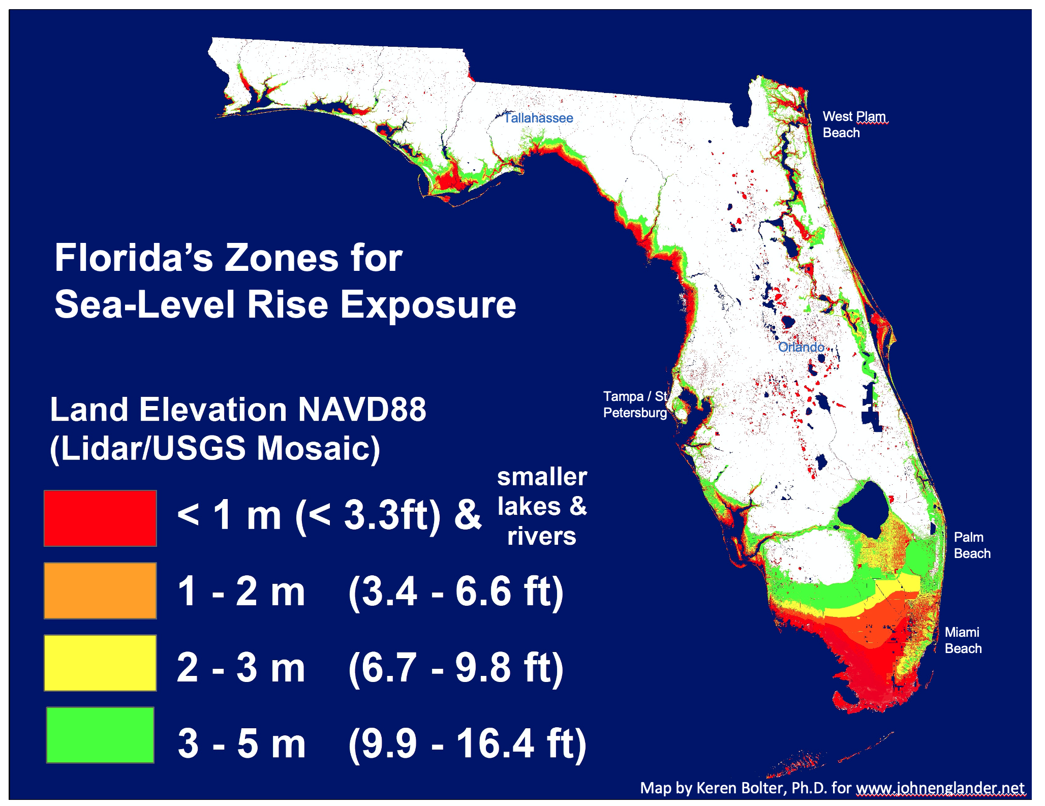
The most pressing challenge for Florida is its vulnerability to sea level rise. With much of its population and infrastructure concentrated along its extensive coastlines, even small increases in average sea level have disproportionate impacts. Higher sea levels lead to more frequent nuisance flooding, especially during high tides and storm events, affecting cities like Miami Beach and St. Petersburg. Over the long term, this threatens coastal wetlands, freshwater supplies, and potentially renders vast tracts of land uninhabitable, reshaping the very geography of the state. The Florida Keys, with their minimal elevation, are particularly at risk.
Storm Surge and Hurricane Impacts
Florida’s low elevation also exacerbates the impacts of tropical storms and hurricanes. Storm surge, the abnormal rise of water generated by a storm, can inundate vast areas far inland from the immediate coastline. The flat topography offers little resistance to these powerful surges, allowing floodwaters to spread widely and cause extensive damage to both natural and built environments. The protective role of barrier islands and mangrove forests becomes even more critical in this context, acting as natural defenses against the ocean’s fury.
Adaptive Strategies and Conservation Efforts
In response to these challenges, Florida is at the forefront of developing adaptive strategies. These include restoring natural coastal buffers like mangrove forests and oyster reefs, elevating infrastructure, improving stormwater management systems, and investing in research to understand the complex interactions between rising seas and the state’s unique geology. Conservation efforts, such as the protection of critical wetland areas and the acquisition of environmentally sensitive lands, are vital not only for preserving biodiversity but also for maintaining the natural functions that provide resilience to the landscape. Protecting the hydrological integrity of systems like the Everglades is paramount to Florida’s long-term ecological and economic health.
The Allure of Florida’s Subtlety
Despite, or perhaps because of, its low elevation, Florida offers a landscape of subtle beauty and profound ecological significance. It is a testament to how slight changes in topography can create dramatic differences in natural environments.
A Landscape Defined by Water
The low elevation of Florida fundamentally defines it as a landscape inextricably linked with water. From its pristine beaches to its vast interior wetlands, its crystal-clear springs, and its expansive lakes like Lake Okeechobee, water is the dominant element. This connection to water has shaped the evolution of its flora and fauna, creating unique adaptations and fostering a biodiversity that thrives on this aqueous foundation. The very concept of “land” in Florida is often fluid, blurring into marshes, estuaries, and coastal shallows, making the state a singular natural landmark where land and sea continually converge.

Natural Beauty and Outdoor Pursuits
The natural landmarks of Florida, from the Big Cypress National Preserve to the various state parks and wilderness areas, reveal a beauty that is less about soaring peaks and more about expansive horizons, intricate waterways, and vibrant ecological communities. The flat terrain makes it ideal for activities like kayaking, paddleboarding, and cycling, offering unique perspectives on its rich natural heritage. Birdwatching opportunities are abundant in its wetlands, and the clarity of its springs offers incredible opportunities for snorkeling and diving into pristine freshwater ecosystems. Florida’s low-lying nature is not a limitation but rather the very essence of its distinct natural allure, a testament to the power of water to shape an entire state into a living, breathing landmark.
LifeOutOfTheBox is a participant in the Amazon Services LLC Associates Program, an affiliate advertising program designed to provide a means for sites to earn advertising fees by advertising and linking to Amazon.com. Amazon, the Amazon logo, AmazonSupply, and the AmazonSupply logo are trademarks of Amazon.com, Inc. or its affiliates. As an Amazon Associate we earn affiliate commissions from qualifying purchases.