
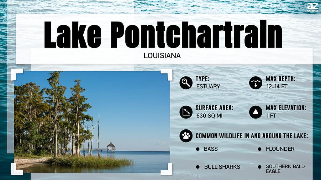
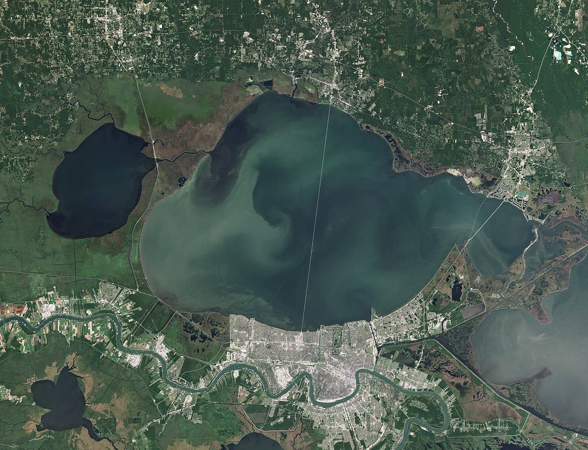
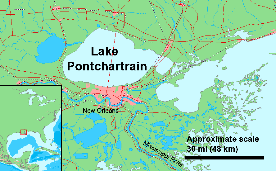
Lake Pontchartrain is one of the most iconic natural landmarks in Louisiana, serving as a central geographical feature that defines the landscape of the southeastern part of the state. Despite its name, this massive body of water is not a lake in the traditional sense; it is a brackish estuary. Stretching across approximately 630 square miles, it serves as a vital bridge between the freshwater rivers of the Northshore and the salty depths of the Gulf of Mexico. For decades, locals and visitors alike have looked out over its vast, shimmering surface and wondered: how deep is Lake Pontchartrain?
Understanding the depth and topography of this landmark is essential for appreciating its role in the ecology, history, and engineering of New Orleans and its surrounding parishes. While it appears as an endless horizon from the shores of Metairie or Mandeville, the reality of its depth is a fascinating study in coastal geography.
The Geographical Profile and Depth of Lake Pontchartrain
To understand the depth of Lake Pontchartrain, one must first understand its classification. As an estuary, it is a shallow basin where fresh water from rivers meets the salt water of the sea. This unique positioning contributes to a relatively uniform and surprisingly shallow depth profile across its 40-mile width.
Average Depth vs. Maximum Depth
The most striking fact about Lake Pontchartrain is that for its immense surface area, it is remarkably shallow. The average depth of the lake is approximately 12 to 14 feet. To put this in perspective, many residential swimming pools in the United States have deep ends that reach 8 or 10 feet. Because the lake is so shallow, it is highly susceptible to wind and weather patterns. A strong wind from the south can push water toward the northern shores, significantly altering local water levels in a matter of hours.
While the majority of the lake remains at this shallow average, there are specific points where the floor drops much deeper. The maximum natural depth of the lake reaches about 65 feet, though these depths are primarily found in the Rigolets, the deep-water strait that connects the lake to Lake Borgne and the Mississippi Sound. Within the main body of the lake itself, human intervention has created deeper pockets. Dredged shipping channels and the areas near the Inner Harbor Navigation Canal (also known as the Industrial Canal) feature depths maintained for maritime traffic.
Geological Formation and Bottom Composition
The basin that contains Lake Pontchartrain was formed over several thousand years as the Mississippi River shifted its course and deposited silt and sediment. Unlike the rocky, deep lakes of the Appalachian Mountains or the glacial gouges of the Great Lakes, the bottom of Lake Pontchartrain is composed primarily of soft silt, clay, and sand.
This composition is a result of the deltaic cycle of Southern Louisiana. Because the floor is so soft and the water is so shallow, the lake stays turbid. Wave action easily stirs up the bottom sediment, which is why the water often appears “chocolatey” or brownish rather than clear blue. This sediment-rich environment is a hallmark of Louisiana coastal landmarks and is essential for the local food web.
The Role of Dredging and Channels
Man-made modifications have significantly altered the bathymetry of the lake. Historically, shell dredging was a major industry in the United States, and Lake Pontchartrain was a primary source of clam shells used for road construction. This practice, which ended in the 1990s, left “pockmarks” and uneven areas on the lake floor. Additionally, the Chef Menteur Pass serves as another natural deep-water connection, similar to the Rigolets, where depths can reach significantly lower than the 12-foot average found in the center of the lake.
Architectural and Engineering Landmarks of the Lake
Because Lake Pontchartrain is so vast yet shallow, it has presented unique challenges and opportunities for engineers over the last century. Several world-famous landmarks have been constructed across or along its waters, forever changing the skyline of New Orleans and the Northshore.
The Lake Pontchartrain Causeway
The most famous landmark associated with the lake is the Lake Pontchartrain Causeway. Holding the Guinness World Record for the longest continuous bridge over water, the Causeway consists of two parallel bridges that span 23.87 miles.
The depth of the lake played a crucial role in the bridge’s design. Because the water is consistently shallow, engineers were able to use thousands of concrete pilings driven deep into the lake’s silty floor. If the lake were as deep as Lake Tahoe or even parts of the Atlantic Ocean, such a bridge would have been economically and technologically unfeasible in the 1950s. Today, the Causeway remains a vital artery connecting Jefferson Parish to St. Tammany Parish.
The Bonnet Carré Spillway
Located on the southwestern edge of the lake, the Bonnet Carré Spillway is a massive flood control structure and a landmark of hydraulic engineering. When the Mississippi River reaches flood stage, the U.S. Army Corps of Engineers opens the spillway to divert water into Lake Pontchartrain.
This event temporarily changes the “depth” and the salinity of the lake. The influx of fresh water from the Mississippi River can raise the lake’s level and introduce massive amounts of river silt. This engineering landmark is essential for the protection of New Orleans, acting as a safety valve for the entire region.
Historic Lighthouses and Forts
Along the shores of the lake, several historical landmarks stand as sentinels of the past. The New Canal Lighthouse, located in West End, has been a beacon for sailors navigating the lake since the 19th century. Although it was nearly destroyed by Hurricane Katrina, it has been meticulously rebuilt.
Further east, Fort Pike stands near the Rigolets. This brick fortification was built after the War of 1812 to defend the water approaches to New Orleans. The strategic placement of Fort Pike at one of the lake’s deepest points emphasizes the historical importance of the lake’s geography in national defense.
Ecological Significance of a Shallow Estuary
The shallow nature of Lake Pontchartrain is not just a matter of measurement; it is the defining characteristic of its ecosystem. The sunlight can reach much of the lake floor, fueling the growth of seagrasses and supporting a diverse range of aquatic life.
The Brackish Water Dynamics
Because it is connected to the Gulf of Mexico, the lake contains a mixture of salt and fresh water. The salinity levels vary depending on rainfall and the opening of the Bonnet Carré Spillway. This environment supports both freshwater species, such as catfish and largemouth bass, and saltwater species, such as red drum, speckled trout, and blue crabs.
The lake is also a seasonal home to West Indian Manatees, which migrate from Florida during the summer months. These gentle giants thrive in the shallow, warm waters where they can easily find vegetation to graze on.
Restoration and Conservation Efforts
For many years, Lake Pontchartrain suffered from pollution and the effects of shell dredging. However, the formation of the Pontchartrain Basin Foundation (now known as Restore the Mississippi Delta partners) led to a massive cleanup effort. Today, the lake is cleaner than it has been in decades, and Pontchartrain Beach remains a nostalgic landmark for those who remember the mid-20th-century glory days of the lakefront.
The shallow depths allow for the growth of Vallisneria americana, also known as wild celery or tape grass. These grass beds are essential for filtering the water and providing a nursery for juvenile fish and shrimp. Protecting the “bottom” of the lake is just as important as protecting the water itself.
The Lake as a Cultural and Historical Landmark
Beyond the statistics of its depth, Lake Pontchartrain holds a central place in the cultural identity of Louisiana. It has inspired artists, musicians, and writers, serving as the backdrop for the evolution of New Orleans.
Native American Heritage and Early Discovery
Long before the arrival of European explorers, the Acolapissa and Choctaw people lived along the shores of the lake. They called it “Okwata,” which means “Wide Water.” In 1699, French explorer Pierre Le Moyne d’Iberville renamed the body of water in honor of Louis Phélypeaux, the Comte de Pontchartrain, who was the French Minister of Marine.
The lake served as a back-door entrance to New Orleans, allowing traders to avoid the difficult upstream trek on the Mississippi River. This geographical advantage was entirely dependent on the navigable channels and the lake’s connection to the Gulf of Mexico.
The Lake in Modern Times
Today, the lakefront is a hub of activity. From the Orleans Parish seawall to the St. Tammany Parish marshes, the lake is a landmark for recreation. Sailing is a major tradition here, with the Southern Yacht Club—one of the oldest in the United States—calling the lake home.
The shallow depth means that the lake can “kick up” quickly, creating short, choppy waves that challenge even experienced sailors. This unique physical characteristic has shaped the design of local “Lafitte skiffs” and other shallow-draft vessels used by Louisiana fishermen for centuries.
A Landmark of Resilience
Perhaps the most significant chapter in the lake’s history is its role during Hurricane Katrina in 2005. The storm surge pushed the shallow waters of the lake into the canal system, leading to levee failures that devastated New Orleans, St. Bernard Parish, and Plaquemines Parish.
Since then, the Greater New Orleans area has seen the construction of the HSDRRS (Hurricane and Storm Damage Risk Reduction System), including the massive Inner Harbor Navigation Canal Lake Borgne Surge Barrier. These engineering landmarks now stand as a testament to the city’s relationship with the lake—a relationship defined by both beauty and the necessity of management.
In conclusion, Lake Pontchartrain is far more than just a body of water. Its shallow average depth of 12 feet belies its massive importance as a natural and historical landmark. From the record-breaking Lake Pontchartrain Causeway to the diverse ecosystems of its brackish waters, the lake remains a vital part of the Louisiana experience. Whether you are crossing its expanse on your way to Madisonville or enjoying a sunset at Bucktown, the depth of the lake—both literal and metaphorical—continues to define the spirit of the region.
LifeOutOfTheBox is a participant in the Amazon Services LLC Associates Program, an affiliate advertising program designed to provide a means for sites to earn advertising fees by advertising and linking to Amazon.com. Amazon, the Amazon logo, AmazonSupply, and the AmazonSupply logo are trademarks of Amazon.com, Inc. or its affiliates. As an Amazon Associate we earn affiliate commissions from qualifying purchases.