
The shimmering expanse of the San Francisco Bay is a defining feature of the region, a vast waterway that shapes its geography, influences its climate, and offers a playground for countless activities. For many visiting or even living in the surrounding cities, the Bay is a constant presence, a stunning backdrop to daily life and a source of endless fascination. One of the most common questions that arises when contemplating this magnificent body of water is simply: how deep is it? The answer, however, is not a straightforward figure, as the depth of the San Francisco Bay is a complex tapestry woven from natural topography, human engineering, and the dynamic forces of tidal action.
A Variable Depth: Understanding the Bay’s Hydrography
The depth of the San Francisco Bay varies dramatically from its shallow, marshy edges to its deepest channels. These variations are not static; they are influenced by a confluence of factors that create a dynamic and ever-changing underwater landscape.
Natural Topography and Bathymetry
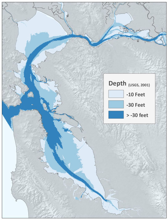
At its most fundamental level, the Bay’s depth is dictated by the underlying landforms. The Bay itself is a drowned river valley, carved out over millennia by the erosive power of the Sacramento River and the San Joaquin River as sea levels rose after the last ice age. These ancient riverbeds now form the deepest parts of the Bay.
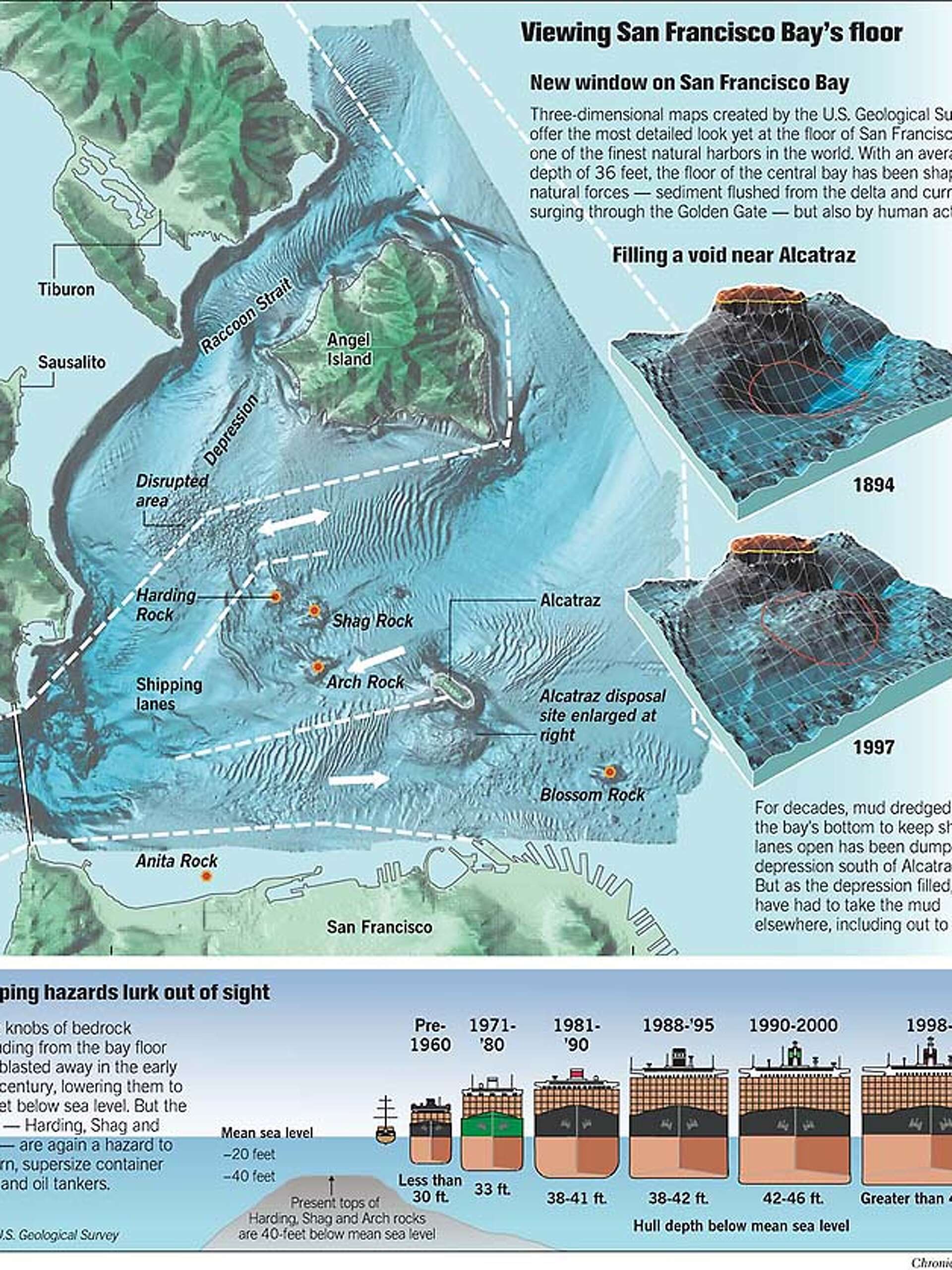
- The Main Channel: The most significant depth is found in the main shipping channel, a crucial artery for maritime traffic. This channel has been extensively dredged over the years to accommodate large vessels. Its depths can reach over 100 feet (approximately 30 meters) in some sections.
- Shallow Flats and Estuaries: In stark contrast, the Bay’s edges are characterized by vast, shallow mudflats and tidal marshes. These areas, often exposed at low tide, can be only a few feet deep, if that. They are vital ecosystems, supporting a rich diversity of birdlife and marine invertebrates. Areas like the Moffett Federal Airfield in Mountain View sit adjacent to extremely shallow, reclaimed land.
- Seismic Influence: The region’s seismic activity also plays a role. Fault lines beneath the Bay have influenced its geological formation, contributing to the unevenness of its floor.
The Impact of Tides and Currents
The ebb and flow of the tides are a powerful force in shaping the Bay’s underwater environment. The San Francisco Bay experiences a semidiurnal tide, meaning there are two high tides and two low tides approximately each day.
- Tidal Range: The difference between high and low tide can be significant, particularly in the northern parts of the Bay. This tidal range can expose large areas of mudflats and alter the depth of channels by several feet. Navigators and those recreating on the water must be acutely aware of these tidal fluctuations.
- Tidal Currents: The movement of water during tidal changes creates strong currents. These currents can scour the Bay floor, deepening certain areas and depositing sediment in others, thereby constantly modifying the bathymetry. The areas around the Golden Gate Bridge are known for particularly strong tidal currents.
Human Intervention: Dredging and Infrastructure
The depth of the San Francisco Bay has been significantly altered and maintained by human intervention, primarily through dredging, to facilitate navigation and support economic activity.
Maintaining Navigable Waterways
The economic importance of the Bay as a port and a transportation corridor has necessitated extensive dredging operations.
- The Federal Navigation Channel: The U.S. Army Corps of Engineers has undertaken massive dredging projects to create and maintain deep-water channels that allow large commercial ships to access ports throughout the Bay, including Oakland and San Francisco. These channels are maintained at depths typically ranging from 40 to 50 feet (12 to 15 meters), with some sections going deeper to accommodate the largest container ships and oil tankers.
- Port Infrastructure: Around the ports, dredging has been particularly intensive to create berths for ships and turning basins for maneuverability. The depths in these operational areas are often significantly greater than the natural depths.
- Spoil Disposal: The material removed during dredging, known as spoil, is a significant consideration. Historically, spoil was often dumped back into the Bay, contributing to altered sediment distribution. Modern practices involve disposing of spoil at designated offshore sites or using it for beneficial reuse, such as wetland restoration projects.
Bridges and Underwater Structures
The construction of major bridges and other underwater infrastructure also influences the Bay’s depth profile.
- Bridge Piers: The massive piers supporting iconic structures like the San Francisco-Oakland Bay Bridge and the Golden Gate Bridge extend downwards from the surface, often to bedrock. While they occupy a volume of water, their primary impact on overall depth is localized.
- Tunnels and Pipelines: Submerged tunnels and pipelines also traverse the Bay floor, but their impact on the overall depth is generally minimal, often being buried beneath the seabed.

Exploring the Depths: Activities and Considerations
Understanding the varying depths of the San Francisco Bay is crucial for anyone planning to engage with its waters, whether for leisure or for work.
Boating and Sailing
For sailors and boaters, the depth of the Bay is a primary concern for safe navigation.
- Charted Depths: Nautical charts provide detailed information on depths, which are crucial for avoiding grounding. These charts reflect both natural bathymetry and the results of dredging.
- Safe Anchorages: Popular anchorages are chosen based on sufficient depth to ensure vessels remain afloat at all stages of the tide.
- Shallow Areas: Many areas, especially near shorelines and around the San Francisco Bay National Wildlife Refuge, are too shallow for larger vessels and require careful navigation or are best avoided by powerboats.
Kayaking and Paddleboarding
For human-powered craft, the shallows can be an advantage, offering access to areas inaccessible to larger boats.
- Exploring Marshes: Kayakers can explore the intricate channels within tidal marshes at high tide, experiencing the rich biodiversity of these sensitive environments.
- Tidal Awareness: Even for these activities, understanding tidal currents and the risk of being stranded on mudflats at low tide is paramount.
Fishing and Marine Life
The depth of the Bay directly influences the types of marine life found within it.
- Deeper Channels for Larger Fish: Deeper channels and areas near the mouth of the Bay, where it meets the Pacific Ocean, tend to attract larger predatory fish.
- Shallow Zones for Forage: The shallower areas and mudflats are critical nurseries and feeding grounds for smaller fish and invertebrates, which in turn support larger marine animals and birds.
- Temperature and Salinity: Depth also plays a role in water temperature stratification and salinity levels, which are critical factors for the health of the Bay’s diverse ecosystems.
The Bay’s Future: Ongoing Changes and Challenges
The depth of the San Francisco Bay is not a static measurement but a constantly evolving characteristic. Several factors continue to influence its underwater landscape.
Sedimentation and Sea Level Rise
- Natural Sedimentation: Rivers continue to carry sediment into the Bay, and tidal currents redistribute it. While dredging counteracts this in some areas, natural processes are always at play.
- Impact of Climate Change: As global temperatures rise, sea levels are also expected to increase. This will have a profound impact on the Bay, potentially inundating more low-lying areas and altering shoreline dynamics. It may also necessitate further dredging to maintain existing navigation depths as the water level rises.
Environmental Concerns and Restoration
- Habitat Restoration: There is a growing focus on restoring tidal marshes and other habitats within the Bay. These efforts often involve managing sediment and water flow, which can indirectly affect depths in specific areas.
- Water Quality: Understanding depth and water circulation is also crucial for managing water quality and addressing issues like dissolved oxygen levels and pollutant dispersion.
In conclusion, the depth of the San Francisco Bay is a dynamic and multifaceted aspect of this iconic waterway. From its naturally carved deep channels to its vast, shallow mudflats, and from the powerful forces of the tides to the significant impact of human dredging, the Bay’s underwater topography is a testament to both natural processes and human endeavor. For visitors and residents alike, appreciating this complexity enhances the experience of this magnificent aquatic landscape.
LifeOutOfTheBox is a participant in the Amazon Services LLC Associates Program, an affiliate advertising program designed to provide a means for sites to earn advertising fees by advertising and linking to Amazon.com. Amazon, the Amazon logo, AmazonSupply, and the AmazonSupply logo are trademarks of Amazon.com, Inc. or its affiliates. As an Amazon Associate we earn affiliate commissions from qualifying purchases.