
The Hawaiian Islands represent one of the most fascinating geological spectacles on Earth. Emerging from the vast depths of the Pacific Ocean, this archipelago is not just a collection of tropical paradises but a testament to the raw, creative power of volcanic activity. Unlike many island chains that form at the boundaries of tectonic plates, the Hawaii chain was forged in the middle of a plate, a process that has puzzled and intrigued scientists for decades. Understanding how these islands formed requires a journey through deep time, exploring the movement of the Earth’s crust and the persistent fire burning beneath the ocean floor.

The Geological Birth of the Hawaiian Archipelago
The story of the Hawaiian Islands begins far beneath the surface of the Pacific Plate. Most volcanic activity on our planet occurs at the edges of tectonic plates—where they either pull apart, like in the Atlantic Ocean, or crash together, like the Ring of Fire surrounding the Pacific Ocean. However, Hawaii is located right in the middle of one of the largest tectonic plates, thousands of miles from any plate boundary.
The Hotspot Theory
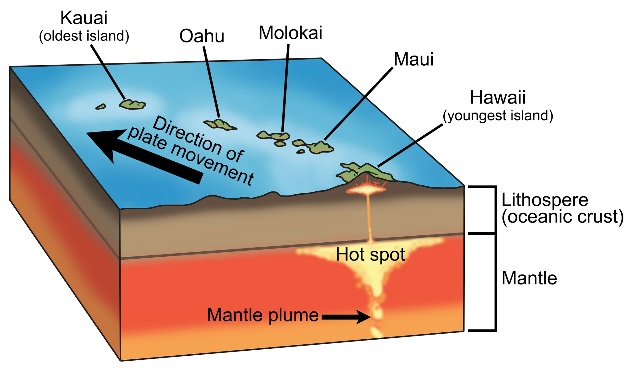
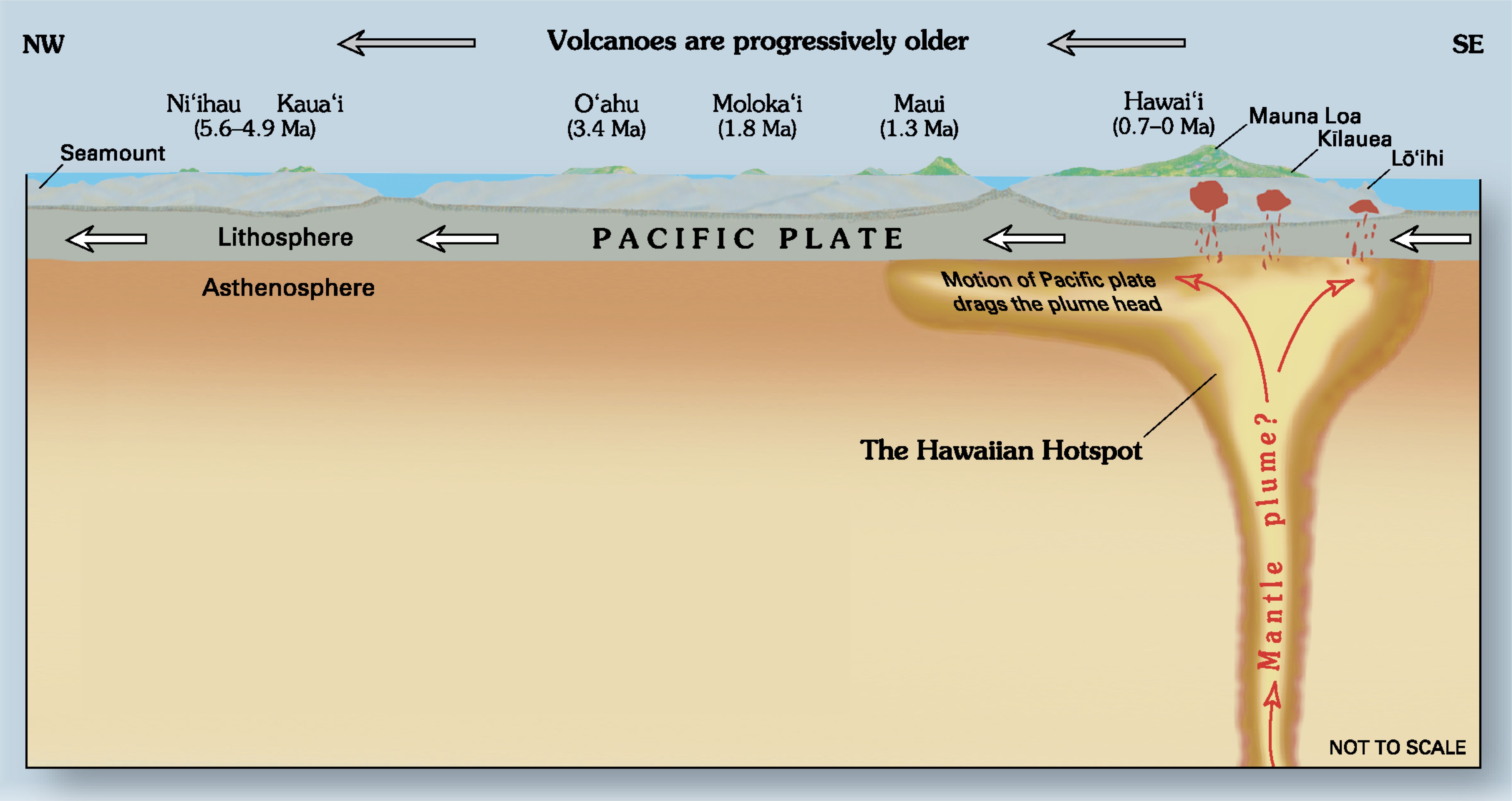
In 1963, a geophysicist named J Tuzo Wilson proposed a groundbreaking theory to explain this anomaly: the “hotspot” theory. He suggested that there are fixed spots within the Earth’s mantle where plumes of intense heat rise toward the surface. This Hawaiian Hotspot remains stationary while the Pacific Plate drifts slowly over it.
As the plate moves, the hotspot melts the crust above it, creating a volcano. Over millions of years, as the plate continues its northwest migration, the older volcano is carried away from the heat source and becomes extinct, while a new volcano begins to form directly over the hotspot. This process has created a chronological trail of islands, seamounts, and atolls stretching over 3,700 miles across the Pacific Ocean, known as the Hawaiian-Emperor Seamount Chain.
Tectonic Plate Movement and the “L” Bend
The Pacific Plate moves at a rate of approximately 3 to 4 inches per year—roughly the same speed at which human fingernails grow. This constant movement is why the Hawaiian Islands are arranged in a linear fashion. If you look at a map of the entire chain, you will notice a distinct “bend” in the line of seamounts. This bend, which occurred about 47 million years ago, indicates a significant shift in the direction of the Pacific Plate movement. This geological landmark tells a story of global tectonic shifts that redirected the path of island formation toward the southeast, eventually leading to the creation of the modern islands we recognize today.
From Seamounts to Shield Volcanoes
The transition from a hole in the ocean floor to a towering mountain involves several distinct stages of volcanic evolution. Every landmark in Hawaii, from the rugged cliffs of Kauai to the active craters on Hawaii Island, has passed through these phases.
The Lifecycle of a Hawaiian Island
An island’s life begins in the submarine stage. Magma erupts onto the ocean floor, cooling rapidly and building up layers of basaltic rock. At this stage, the structure is known as a seamount. As eruptions continue over hundreds of thousands of years, the seamount eventually breaks the surface of the water, entering its most productive phase: the shield-building stage.
During this stage, the volcano produces fluid, runny lava that spreads out in thin sheets, creating a broad, gently sloping profile that resembles a warrior’s shield. This is how the massive landmarks of Mauna Loa and Mauna Kea were formed. Once the island moves off the hotspot, the volcanic activity slows down and eventually stops. The island then enters a long period of erosion and subsidence, eventually sinking back beneath the waves to become an atoll or a flat-topped guyot.
Mauna Kea and Mauna Loa: The World’s Tallest Peaks
When measuring from the sea floor to the summit, Mauna Kea is technically the tallest mountain in the world, surpassing even Mount Everest. Rising over 33,000 feet from the abyssal plain, its massive presence is a direct result of the hotspot’s efficiency. Its neighbor, Mauna Loa, is the world’s largest subaerial volcano by volume and area covered. These two landmarks define the landscape of the Big Island and serve as the ultimate examples of the power of shield volcanism.
Exploring the Oldest and Newest Landmarks
The age of the Hawaiian Islands increases as you travel from the southeast to the northwest. This age gradient has created vastly different landscapes across the chain, ranging from the jagged, emerald spires of the older islands to the stark, black lava fields of the younger ones.
Kauai: The Garden Isle’s Ancient Roots
Kauai is the oldest of the main inhabited islands, formed approximately 5 million years ago. Because it has been away from the hotspot for so long, it has been heavily sculpted by the elements. The Napali Coast, with its sheer 3,000-foot cliffs, and Waimea Canyon, often called the “Grand Canyon of the Pacific,” are the results of millions of years of rainfall and erosion. These landmarks showcase a stage of island life where the creative fires have been replaced by the transformative power of water and wind.
Hawaii Island: The Growing Giant
At the opposite end of the chain lies Hawaii Island, often called the Big Island. It is less than a million years old and is still actively growing. The landmark of Kilauea is one of the most active volcanoes on Earth, having been in a state of nearly constant eruption for decades. Here, visitors can witness the formation of new land in real-time as lava flows into the sea, creating steam plumes and expanding the island’s coastline.
Kama‘ehuakanaloa: The Future of the Chain
The process of island formation is far from over. About 20 miles off the southeast coast of the Big Island lies Kama‘ehuakanaloa, formerly known as Loihi Seamount. This active submarine volcano is the next island in the Hawaiian chain. Its summit is currently about 3,000 feet below sea level. While it may take another 10,000 to 100,000 years to break the surface, Kama‘ehuakanaloa is a reminder that the hotspot remains active, and the Pacific Plate continues its relentless journey.
Natural Wonders Forged by Fire and Water
Beyond the massive volcanoes themselves, the unique formation of Hawaii has created specific landmarks that are world-renowned for their geological and aesthetic value.
Diamond Head and the Honolulu Volcanics
One of the most recognizable landmarks in the world is Diamond Head on the island of Oahu. While the main shield-building phase of Oahu ended long ago, the island experienced a period of “rejuvenation” volcanism. This occurs when small pockets of magma find their way to the surface after the island has moved past the hotspot. Diamond Head, or Leahi, is a tuff cone formed by a single, explosive eruption around 300,000 years ago. This landmark, along with Hanauma Bay and Punchbowl Crater, defines the dramatic skyline of Honolulu.
Haleakala and the Maui Nui Complex
The island of Maui was once part of a much larger landmass known as Maui Nui, which included Molokai, Lanai, and Kahoolawe. As the islands aged and the crust began to sink, the valleys between the volcanic peaks flooded, creating the separate islands we see today. The crowning landmark of Maui is Haleakala, a massive shield volcano that makes up 75% of the island. Its “crater” is actually an erosional valley formed by two massive river systems that met at the summit, creating a moon-like landscape that is unique in the Pacific.
Preserving the Sacred Landscapes of Hawaii
The geological history of Hawaii is deeply intertwined with its cultural and spiritual heritage. For the Native Hawaiians, these landmarks are not just rocks and soil; they are living ancestors.
Hawaii Volcanoes National Park
Established in 1916, Hawaii Volcanoes National Park is a UNESCO World Heritage Site that protects the most active volcanic regions on the Big Island. The park serves as a laboratory for scientists and a sanctuary for visitors to witness the creation of the world. Landmarks within the park, such as the Halemaumau Crater, are considered the home of Pele, the deity of fire and volcanoes. The park preserves both the physical land and the stories that have been told about it for centuries.
Cultural Significance of the Volcanic Peaks
High-altitude landmarks like Mauna Kea are considered wao akua, the realm of the gods. The formation of these mountains provided more than just land; it provided a temple for spiritual practice and a source of life-giving water. The snow that falls on Mauna Kea and Mauna Loa recharges the aquifers that sustain life on the islands below.
By understanding how the Hawaiian Islands formed, we gain a deeper appreciation for their fragility and their strength. From the first spark of the Hawaiian Hotspot to the eroding cliffs of the North Shore, the geological journey of Hawaii is a continuous cycle of birth, growth, and return to the sea. These landmarks stand as silent witnesses to the incredible forces that shape our world, offering a window into the very heart of the Earth.
LifeOutOfTheBox is a participant in the Amazon Services LLC Associates Program, an affiliate advertising program designed to provide a means for sites to earn advertising fees by advertising and linking to Amazon.com. Amazon, the Amazon logo, AmazonSupply, and the AmazonSupply logo are trademarks of Amazon.com, Inc. or its affiliates. As an Amazon Associate we earn affiliate commissions from qualifying purchases.