
Navigating the vast distances that separate us from our desired destinations is a common prelude to any great adventure. For those with their sights set on the vibrant and eclectic capital of Texas, the question “How far am I from Austin, Texas?” is not just about mileage; it’s about the anticipation of unique experiences, the promise of live music, and the allure of a city that consistently punches above its weight in culture and culinary innovation. Whether you’re embarking on a cross-country road trip, planning a short flight for a weekend getaway, or simply curious about your proximity to this thriving hub, understanding the distance is the first step in crafting your perfect journey.

Understanding Your Journey to Austin
The distance to Austin, Texas is inherently relative, dependent on your starting point. This section delves into how geographical location influences travel time and mode of transport, offering insights for various traveler profiles.
By Air: The Fastest Route to the Heart of Texas
For many, especially those coming from distant corners of the United States or internationally, air travel is the most efficient way to reach Austin. Austin-Bergstrom International Airport (AUS) is a modern, bustling gateway serving numerous domestic and international routes.
-
Major Hubs and Flight Durations:
- From New York City, a direct flight to Austin typically ranges from 3.5 to 4 hours.
- Traveling from Los Angeles to Austin usually takes about 3 to 3.5 hours on a direct flight.
- For those on the East Coast, cities like Atlanta or Charlotte offer direct flights of around 2.5 to 3 hours.
- From Chicago, expect flights to be approximately 3 hours.
- International travelers might connect through major hubs like Dallas/Fort Worth International Airport (DFW) or Houston George Bush Intercontinental Airport (IAH) before a short hop to Austin.
-
Booking Strategies: To secure the best fares, it’s advisable to book flights several weeks or even months in advance, especially during peak travel seasons like spring for South by Southwest or fall for the Austin City Limits Music Festival. Airlines like American Airlines, Southwest Airlines, and United Airlines are major carriers serving AUS.
By Car: The Quintessential American Road Trip
The open road offers a distinct perspective on the journey to Austin. The “how far” here is measured in hours of driving, fuel stops, and the potential for scenic detours.
-
Key Interstate Highways:
- The most common routes to Austin involve major interstates. From the north, Interstate 35 (I-35) is a primary artery, connecting cities like Oklahoma City, Dallas, and Waco directly to Austin.
- From the west, Interstate 10 (I-10) can be utilized, connecting through cities like San Antonio before a shorter drive north.
- From the east, routes might involve connecting to I-35 or other state highways.
-
Estimated Driving Times from Major Cities:
- Dallas, Texas: Approximately 3 to 3.5 hours.
- Houston, Texas: Roughly 2.5 to 3 hours.
- San Antonio, Texas: About 1.5 hours, making it a popular day trip or short stay destination before heading to Austin.
- New Orleans, Louisiana: A longer haul, around 7 to 8 hours.
- Denver, Colorado: This is a significant road trip, typically taking 13 to 15 hours of driving time, best broken up over two days.
- Phoenix, Arizona: A substantial journey, estimated at 15 to 17 hours, requiring an overnight stop.
-
Planning Your Road Trip: Beyond the pure mileage, consider factors like traffic congestion, especially around major metropolitan areas like Dallas and Houston. Utilizing GPS navigation apps like Google Maps or Waze can provide real-time traffic updates and alternative routes. Factor in breaks for meals and to stretch your legs; the journey itself can be as enriching as the destination.
By Train: A Leisurely Pace Through the Landscape
While not as prevalent as flying or driving for reaching Austin, train travel offers a relaxed and scenic alternative for certain routes.
-
Amtrak Service: Amtrak operates routes that can connect to Austin, often requiring transfers. The Texas Eagle route, for example, runs from Chicago to San Antonio, with a bus connection to Austin. This journey is significantly longer than flying, typically spanning over 24 hours from Chicago, but provides a unique perspective on the American landscape.
-
Benefits of Train Travel: For those who prefer to avoid the stress of flying or the constant attention required for driving, train travel offers a chance to relax, read, or simply watch the scenery unfold. Dining cars and comfortable seating can make the extended journey more enjoyable.
Regional Proximity and Day Trip Potential

Understanding how far you are from Austin, Texas also involves recognizing its position within the broader Texan and Southwestern landscape. This proximity opens up possibilities for exploring surrounding areas.
Within Texas: A Network of Neighboring Cities
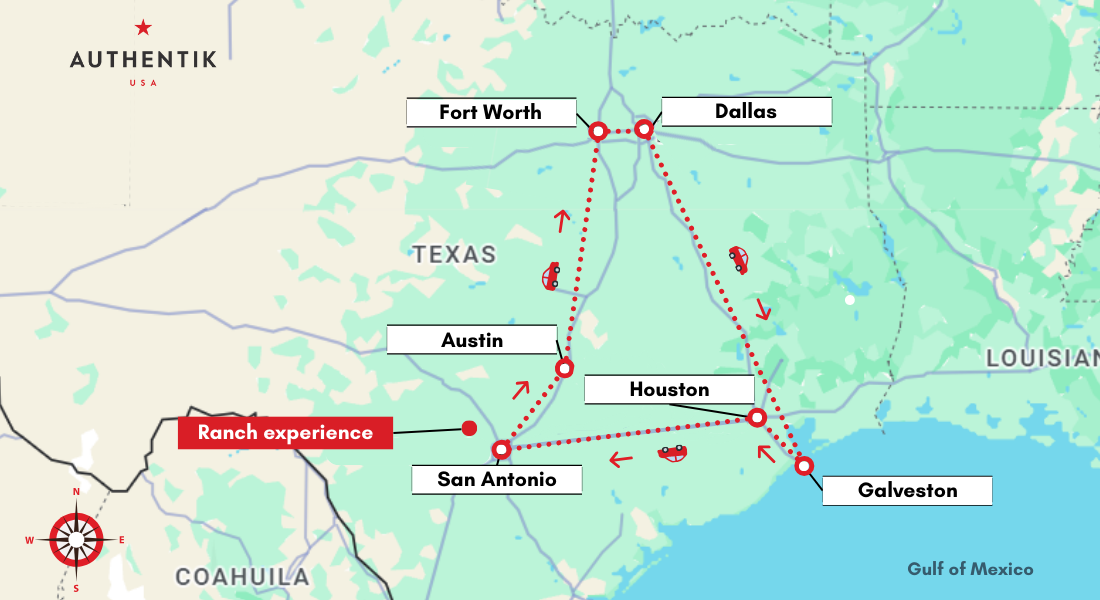
Austin is strategically located within the “Texas Triangle,” a megalopolis formed by Houston, Dallas, and San Antonio.
- San Antonio: Just about 80 miles south of Austin, a comfortable 1.5-hour drive. This historic city boasts the Alamo and a charming Riverwalk, making it an easy addition to an Austin itinerary.
- Houston: Approximately 165 miles southeast, a 2.5 to 3-hour drive. Known for its space exploration at Space Center Houston and a vibrant arts scene.
- Dallas: Around 200 miles north, a 3 to 3.5-hour drive. A major economic and cultural center with attractions like the Dallas Arts District.
- Waco: A much closer neighbor, about 95 miles north on I-35, a 1.5-hour drive. Famous for the Magnolia Market at the Silos.
Beyond Texas: Exploring the Southwest
Austin serves as an excellent starting point for exploring other parts of the Southwest.
- New Mexico: Cities like Santa Fe and Albuquerque are roughly 8 to 10-hour drives from Austin. These destinations offer a rich cultural tapestry with Pueblo history, distinct cuisine, and stunning desert landscapes.
- Oklahoma: As mentioned, Oklahoma City is a manageable 3 to 4-hour drive north via I-35. Further north, the Wichita Mountains National Wildlife Refuge offers natural beauty.
- Louisiana: The allure of New Orleans, with its unique jazz heritage and Creole flavors, is about a 7 to 8-hour drive east.
Calculating Your Specific Distance
The most accurate way to determine “How far am I from Austin, Texas?” is to use precise mapping tools.
Digital Mapping Tools: Your Pocket Navigator
Online map services and dedicated travel apps are invaluable for calculating exact distances and estimated travel times.
- Google Maps: Simply input your current location or starting address and “Austin, Texas” as your destination. It will provide multiple route options, driving times, and distance in miles or kilometers. It also offers real-time traffic conditions.
- Apple Maps: Similar to Google Maps, it offers route planning, traffic updates, and estimated travel durations for driving, public transport, and walking.
- Waze: Particularly useful for road trips, Waze provides crowd-sourced traffic information, hazard alerts, and speed trap notifications, optimizing your driving experience.
Factors Influencing Travel Time
It’s crucial to remember that the calculated driving time is an estimate. Several variables can affect your actual journey:
- Traffic: Major cities and popular routes can experience significant congestion, especially during peak hours, holidays, or major events.
- Road Conditions: Construction, accidents, or adverse weather can lead to delays.
- Speed Limits: Adhering to posted speed limits and local regulations is essential for safety and to avoid citations.
- Stops: The time you allocate for rest breaks, meals, and sightseeing will add to your overall travel duration.
International Travelers: Bridging Continents
For those journeying from outside the United States, the distance is measured in transoceanic flights.
- Europe: Flights from major European cities like London, Paris, or Frankfurt typically range from 9 to 11 hours of flight time.
- Asia: Journeys from cities like Tokyo or Beijing are considerably longer, often involving one or more layovers and flight durations exceeding 15 to 20 hours.
- South America: Flights from cities like Mexico City are relatively short, around 3 to 4 hours. From further south, like São Paulo or Buenos Aires, expect flight times to be 9 to 12 hours, often with a connection.
Understanding the distance from Austin, Texas is more than just a numerical calculation; it’s the foundation for planning your adventure. Whether you’re drawn by the promise of its renowned music scene, the quirky charm of its local culture, or the vibrant culinary landscape, knowing your distance empowers you to embark on a well-prepared and exciting journey to the heart of the Lone Star State.
LifeOutOfTheBox is a participant in the Amazon Services LLC Associates Program, an affiliate advertising program designed to provide a means for sites to earn advertising fees by advertising and linking to Amazon.com. Amazon, the Amazon logo, AmazonSupply, and the AmazonSupply logo are trademarks of Amazon.com, Inc. or its affiliates. As an Amazon Associate we earn affiliate commissions from qualifying purchases.