
The allure of traveling from the dazzling entertainment capital of Las Vegas, Nevada, to the vast and diverse landscapes of California is undeniable. For many, this journey represents a transition from high-octane excitement to serene coastlines, majestic mountains, or bustling metropolitan centers. While geographically close, the actual distance and travel time can vary dramatically depending on your specific destination within the Golden State. Understanding this proximity and the various travel logistics is key to planning an unforgettable Southwestern adventure.
The Proximity and the Paradox: Understanding the Nevada-California Border
Las Vegas is situated in the southernmost tip of Nevada, placing it remarkably close to the California state line. In fact, the border itself is merely about 40 to 50 miles west of the Las Vegas Strip, making California the closest neighboring state for many Las Vegas residents and visitors looking for a quick getaway.
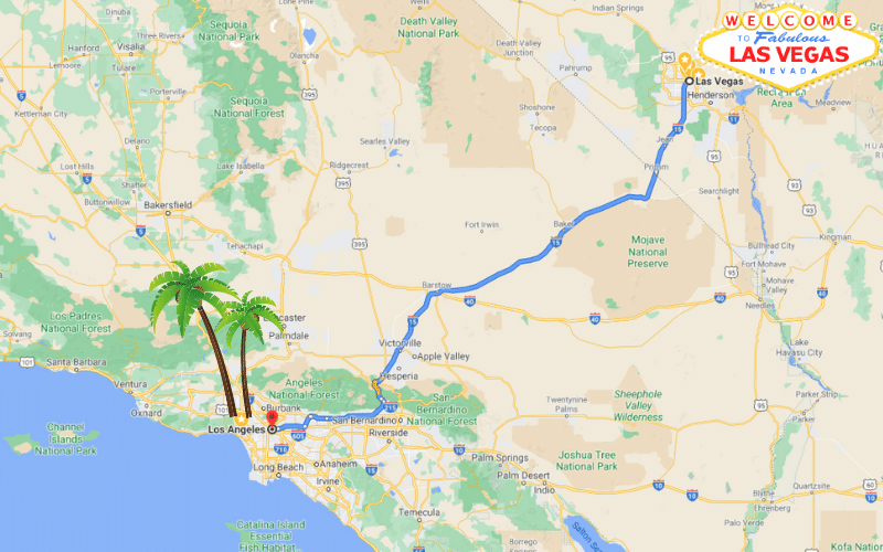
However, the question “How far from Las Vegas to California?” presents a paradox because “California” is not a single point but an immense state stretching over 800 miles from north to south. This means the journey could be a mere hour’s drive to a desert outpost or a full day’s expedition to a northern city or national park. The perceived “distance” hinges entirely on your intended destination within California, each offering a distinct experience and requiring different travel considerations.
Key California Destinations from Las Vegas and Their Distances
To truly answer the question, it’s essential to break down the travel distances to popular California locales. These estimates primarily consider driving, as it’s the most common and flexible mode of transport for this route.
Southern California Hotspots
The majority of travelers from Las Vegas venture into Southern California, known for its beaches, theme parks, and vibrant cities.
- Los Angeles: As one of the most popular destinations, the drive from Las Vegas to Los Angeles typically spans approximately 270 miles. Depending on traffic, which can be notoriously heavy around Los Angeles and on Interstate 15 itself, this journey can take anywhere from 4 to 6 hours. Destinations within Los Angeles County like Hollywood, Santa Monica, or Downtown LA will add marginal variances to this total.
- San Diego: Further south along the Pacific Coast, San Diego offers a relaxed vibe and beautiful beaches. The distance is roughly 330 miles, translating to a driving time of 5 to 7 hours, often involving a drive through Los Angeles before heading south.
- Orange County (Anaheim, Disneyland): Home to the iconic Disneyland Resort, Anaheim is approximately 260 miles from Las Vegas. The drive typically takes between 4 to 5.5 hours, depending on the time of day and traffic conditions around the LA metropolitan area.
- Palm Springs: A desert oasis known for its mid-century modern architecture and resort culture, Palm Springs is about 230 miles from Las Vegas. This journey can be completed in approximately 3.5 to 4.5 hours, offering a relatively straightforward drive.
Central and Northern California Adventures
Venturing beyond Southern California significantly increases travel distances and times but opens up a world of contrasting natural beauty and cultural experiences.
- San Francisco: The iconic “City by the Bay” is a considerable distance from Las Vegas, roughly 560 to 600 miles depending on the route. This translates to a substantial driving time of 9 to 11 hours, making it a trip often broken up with an overnight stop or undertaken as a two-day journey. Travelers might take Interstate 15 north to Barstow and then head west on Highway 58 or Highway 14 to connect with Interstate 5 or Highway 99 through the Central Valley.
- Yosemite National Park: For nature enthusiasts, Yosemite offers unparalleled grandeur. The distance to the park’s eastern entrance (via Tioga Pass, which is seasonal) is about 300-350 miles, taking 6-7 hours. However, driving to the main Yosemite Valley entrance (year-round access) from Las Vegas is closer to 450-500 miles, requiring 8-10 hours of driving. Always check road conditions, especially in winter.
- Lake Tahoe: Straddling the border of California and Nevada, the Lake Tahoe area is approximately 450 miles north of Las Vegas. The drive typically takes between 7 to 9 hours, often passing through scenic desert landscapes and then into the mountainous Sierra Nevada range.
Navigating the Journey: Transportation Options
Choosing the right mode of transport from Las Vegas to California depends on your budget, time constraints, and desired travel experience.
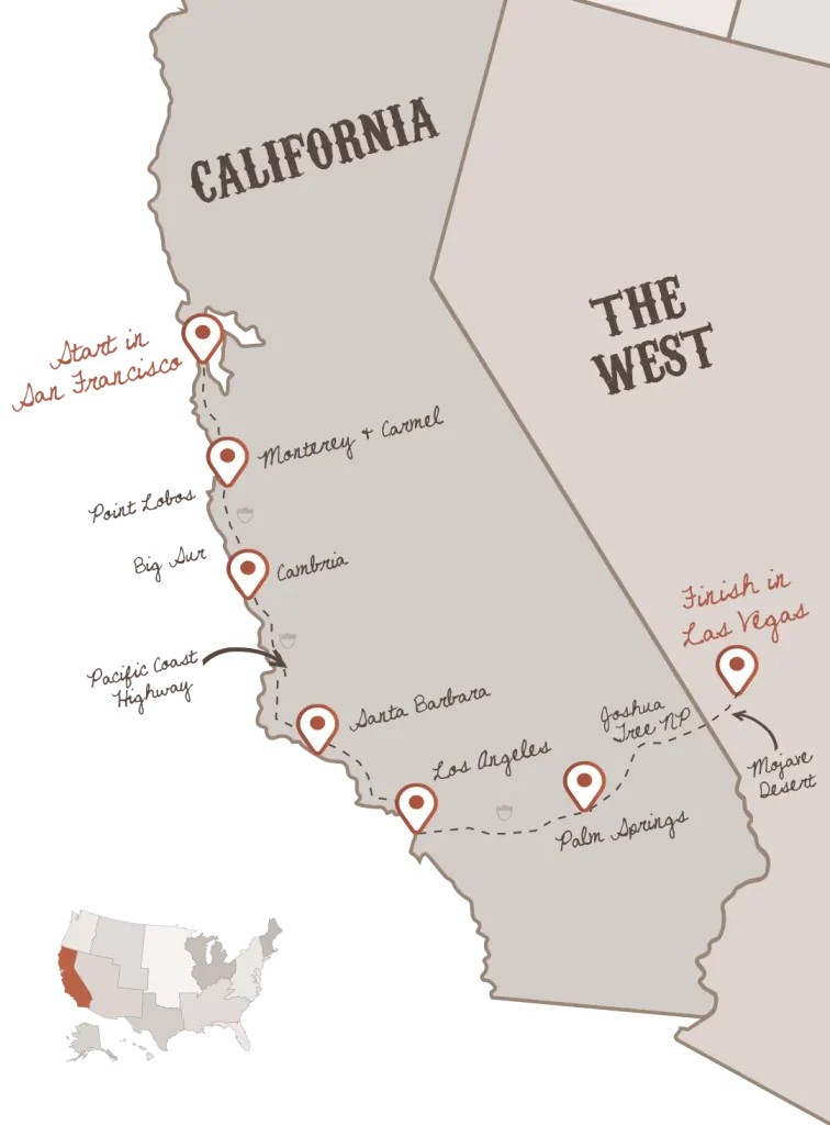
Driving: The Most Common Choice
Driving remains the most popular way to travel between Las Vegas and California, primarily due to its flexibility. The main artery connecting Las Vegas to Southern California is Interstate 15 (I-15).
- Route and Conditions: The I-15 is a major highway, generally well-maintained. However, traffic can be a significant factor, especially on Sunday evenings as many visitors return to California from weekend trips to Las Vegas. Summer heat in the Mojave Desert can be extreme, affecting vehicle performance and driver comfort. Always ensure your vehicle is in good condition, especially tires and cooling systems.
- Stops and Sights: The drive offers opportunities for interesting stops. Barstow, California, is a common refueling and rest stop. For those with more time, detours to natural wonders like Death Valley National Park (seasonal considerations for heat) or the Mojave National Preserve can transform a simple drive into a scenic road trip.
Flying: Speed and Convenience
For those prioritizing speed, flying is an excellent option, especially for destinations further afield like San Francisco or Northern California.
- Major Airports: Harry Reid International Airport (LAS) in Las Vegas offers numerous direct flights to major California airports, including Los Angeles International Airport (LAX), San Francisco International Airport (SFO), San Diego International Airport (SAN), and Oakland International Airport (OAK).
- Flight Times and Cost: Flight durations are typically short, ranging from 1 to 1.5 hours. While faster, flying involves airport check-in, security, and travel to and from airports, which can add significant time. Ticket prices vary widely based on booking time and airline, but often represent a cost-effective option for longer distances.
Bus and Train: Budget-Friendly Alternatives
For budget-conscious travelers or those who prefer not to drive, bus and train services offer viable, albeit slower, alternatives.
- Bus Services: Companies like Greyhound operate regular routes between Las Vegas and various California cities. Travel times are considerably longer than driving or flying due to multiple stops, but they are generally very affordable.
- Train Services: Amtrak provides limited direct train service, primarily connecting Las Vegas via bus connections to train routes in California. For instance, one might take an Amtrak Thruway bus from Las Vegas to Bakersfield, California, and then connect to a train to destinations like Oakland or Sacramento. This is often the longest travel option but can offer a unique, more relaxed travel experience, especially if you enjoy scenic routes.
Planning Your Las Vegas to California Travel Itinerary
Effective planning is crucial for a smooth and enjoyable journey from Las Vegas to any point in California.
- Best Time to Travel: Consider the season. Spring and fall offer pleasant temperatures for driving through the desert. Summer can be intensely hot, increasing stress on vehicles and passengers. Winter travel to northern parts of California or mountainous regions like Yosemite or Lake Tahoe may involve snow and require tire chains. Weekday travel generally experiences less traffic than weekends, especially for the I-15 corridor.
- What to Pack: Pack according to your California destination. Beachwear for San Diego, layers for the often-foggy San Francisco, and hiking gear for national parks. Always carry plenty of water and snacks for any road trip, particularly through desert stretches.
- Making Stops an Experience: Instead of viewing the drive as a chore, consider it part of the adventure. Beyond the practical stops, explore the quirky roadside attractions, ghost towns, or natural beauty found along routes like Route 66 remnants near Barstow or the vastness of the Mojave National Preserve.
- Rental Car Tips: If you’re flying into Las Vegas and planning to drive to California, consider one-way rental options if you don’t intend to return to Las Vegas. Compare prices across different rental companies and book in advance, especially during peak travel seasons. Ensure the rental agreement allows for interstate travel.

Why the Journey Matters: More Than Just Miles
The journey from Las Vegas to California is more than just a matter of miles; it’s a dynamic transition between two iconic American states, each with its own distinct charm and offerings. It’s an opportunity to witness diverse landscapes, from the stark beauty of the Mojave Desert to the vibrant urban sprawl of Los Angeles or the towering redwoods further north.
Whether you’re chasing the sun on a Southern California beach, exploring the cultural tapestry of San Francisco, or seeking adventure in Yosemite National Park, the logistical bridge from Las Vegas is straightforward with proper planning. Embrace the journey as part of the destination, and you’ll find that the distance from Las Vegas to California is simply the starting point for countless adventures waiting to unfold.
LifeOutOfTheBox is a participant in the Amazon Services LLC Associates Program, an affiliate advertising program designed to provide a means for sites to earn advertising fees by advertising and linking to Amazon.com. Amazon, the Amazon logo, AmazonSupply, and the AmazonSupply logo are trademarks of Amazon.com, Inc. or its affiliates. As an Amazon Associate we earn affiliate commissions from qualifying purchases.