
The question of “how far” is often the first step in planning any journey, setting the stage for logistics, timing, and overall travel experience. For those considering a trip between the sprawling metropolis of Los Angeles and the agricultural hub of Bakersfield, understanding the distance and travel implications is paramount. This article serves as a comprehensive guide to navigating this well-trodden route within California, detailing the primary routes, estimated travel times, various transportation options, and practical considerations to ensure a smooth and efficient journey. Whether you’re a local commuting for work, a tourist exploring the diverse landscapes of Southern California, or simply curious about the connection between these two significant cities, this guide will provide all the essential information to plan your travel effectively. From the bustling freeways to more relaxed public transport, we cover every aspect of the journey, ensuring you are well-prepared for the road ahead.
The Core Distance and Travel Time
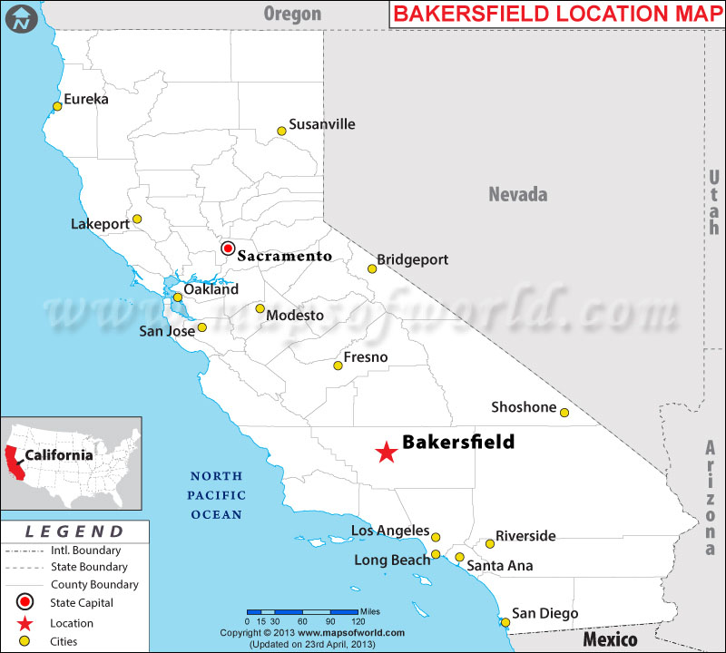
Understanding the exact distance and the realistic time it takes to travel between Los Angeles and Bakersfield is the foundational element of any travel plan. While the crow flies might suggest a shorter path, the reality of navigating California’s diverse terrain and extensive freeway system dictates the practical journey. This section breaks down the direct road distance, provides realistic driving time estimates, and identifies the key arteries connecting these two pivotal California cities.
Direct Road Distance
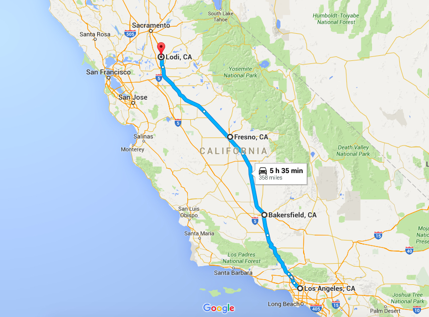
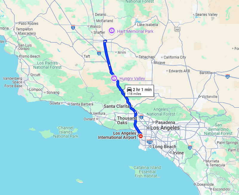
The approximate road distance between downtown Los Angeles and downtown Bakersfield typically ranges from 110 to 120 miles (approximately 177 to 193 kilometers), depending on the specific starting and ending points within each city. This relatively moderate distance makes the route a common connection for commuters, freight transport, and leisure travelers alike. It’s a distance that is easily manageable for a day trip or as part of a longer itinerary through the state. The journey effectively bridges the vibrant urban landscape of Los Angeles with the more relaxed, agriculture-rich environment of the San Joaquin Valley, offering a contrast in scenery and pace.
Estimated Driving Time
While the mileage provides a static figure, the estimated driving time is a more dynamic factor, heavily influenced by traffic conditions, time of day, and any stops made along the way. Under ideal conditions, with light traffic, the drive can be completed in approximately 1 hour and 45 minutes to 2 hours. However, travelers must account for the notorious traffic congestion common in Southern California, particularly when departing from or arriving in Los Angeles. During peak rush hours (typically 6:00 AM – 9:00 AM and 3:00 PM – 7:00 PM on weekdays), travel times can easily extend to 2.5 to 3 hours, or even longer on exceptionally busy days or during holiday periods. It’s crucial to factor in these potential delays when planning your schedule, especially if you have connecting flights or appointments.
Key Routes and Highways
The primary artery connecting Los Angeles and Bakersfield is Interstate 5 (I-5), a major north-south freeway that traverses the length of California. From Los Angeles, travelers will typically head north on I-5. This route takes you through the mountainous region of the Tehachapi Mountains, including the renowned Grapevine Pass, a significant climb and descent that marks the transition into the San Joaquin Valley. Once past the Grapevine Pass, the freeway becomes relatively flat and straight, leading directly into Bakersfield. Some travelers might consider combining I-5 with sections of Highway 99, especially if their destination in Bakersfield is on the eastern side of the city, as Highway 99 runs directly through the heart of Bakersfield. For most direct journeys, however, I-5 remains the most straightforward and fastest option.
Navigating the Journey: Road Travel Insights
While the straightaway mileage gives an initial sense of the trip, the actual experience of driving from Los Angeles to Bakersfield involves understanding specific nuances of the road. This section offers practical insights for drivers, covering traffic patterns, route characteristics, and recommendations for rest stops, ensuring a more informed and comfortable journey.
Peak Traffic Considerations
The biggest variable impacting road travel between these two cities is undoubtedly traffic. The stretch of I-5 exiting Los Angeles can be heavily congested during standard weekday rush hours. Similarly, the northbound ascent and southbound descent of the Grapevine Pass can experience slowdowns due to its winding nature, elevation changes, and the sheer volume of both passenger vehicles and commercial trucks. Weekends, particularly Sunday afternoons and evenings, can also see increased traffic as people return to Los Angeles from trips to the San Joaquin Valley or northern California. For the smoothest ride, consider traveling midday on weekdays, or very early mornings/late evenings. Utilizing real-time traffic apps like Google Maps or Waze is highly recommended for up-to-the-minute updates and to identify potential bottlenecks or accidents that could cause significant delays.
Scenic vs. Fastest Route
For this particular corridor, the primary route via I-5 is almost universally the fastest and most direct. There aren’t significant scenic alternatives that don’t add substantial time to the journey. The I-5 itself offers a varied landscape, transitioning from the urban sprawl of the Los Angeles Basin to the rugged, chaparral-covered hills around the Grapevine Pass, and finally opening up to the vast, agricultural fields of the San Joaquin Valley. While not a designated “scenic highway,” the vistas from the Grapevine Pass can be quite impressive, especially on a clear day, offering panoramic views of the surrounding mountains and the valley below. For those seeking a truly scenic detour, one would have to venture significantly off the direct path, perhaps through the Angeles National Forest or towards the coast, which would convert a two-hour drive into a four-hour or longer expedition. For the purpose of efficient travel between Los Angeles and Bakersfield, I-5 remains the pragmatic choice.
Essential Stops and Amenities
The I-5 corridor between Los Angeles and Bakersfield is well-equipped with services to cater to travelers. Numerous gas stations, fast-food restaurants, and larger travel centers are strategically located, particularly around the towns of Gorman and Lebec near the Grapevine Pass, and then again closer to Bakersfield. These stops are invaluable for refueling, stretching legs, grabbing a meal, or taking a quick rest break. Travelers should be mindful that services directly on the Grapevine Pass itself are limited, so planning stops before the ascent or after the descent is often advisable. Furthermore, during heavy travel periods, these popular stops can become crowded, so patience is key. Having a full tank of gas before embarking on the journey from either city is always a wise precaution, especially before tackling the inclines of the Grapevine Pass.
Alternative Transportation Options
While driving remains the most popular and flexible method of travel between Los Angeles and Bakersfield, it is by no means the only option. A variety of public and shared transportation services offer viable alternatives for those who prefer not to drive, are traveling on a budget, or simply wish to enjoy the journey without the stress of navigating traffic. These options cater to different preferences for comfort, cost, and travel time.
Public Bus Services
Public bus services provide a cost-effective and convenient way to travel between the two cities. Greyhound is the most prominent operator, offering multiple daily departures from the Los Angeles downtown terminal to the Bakersfield station. The journey duration by bus is typically longer than driving, ranging from 2.5 to 3.5 hours, depending on the number of stops and traffic conditions. However, the advantage lies in not having to worry about fuel, parking, or navigation. Tickets are generally affordable, making it an attractive option for budget-conscious travelers. Other regional bus lines or shuttle services might also offer routes, but Greyhound maintains the most extensive network for this specific corridor. Booking tickets in advance, especially during peak travel times, is advisable.
Train Travel
For a more relaxed and scenic journey, train travel via Amtrak is an excellent choice. The Amtrak San Joaquin route connects Bakersfield to Oakland and Sacramento to the north. While there isn’t a direct train line from Bakersfield to Los Angeles through the Grapevine Pass, Amtrak offers a “Thruway Bus Service” that seamlessly connects Bakersfield passengers to trains at nearby stations like Chatsworth or directly to Los Angeles Union Station. The bus portion of the journey mirrors the driving route, offering a comfortable ride. The overall travel time, including the bus and potential train segments, can be around 3 to 4 hours, but passengers enjoy spacious seating, onboard amenities, and the ability to move around. It’s a particularly good option for those who find driving stressful or wish to work or relax during transit.
Air Travel (Limited but Possible)
Given the relatively short distance between Los Angeles and Bakersfield, direct commercial air travel is not a common or practical option. The time spent traveling to and from airports, going through security, and the flight itself would almost certainly exceed the driving time, not to mention the significantly higher cost. Bakersfield has the Meadows Field Airport (BFL), and Los Angeles is served by the massive Los Angeles International Airport (LAX), among others. While private charter flights might exist, for the general public, flying is simply not a viable or efficient means of transport for this specific inter-city route. The closest approximation would be connecting through a major hub like LAX for a longer journey, but for direct travel, it is not recommended.
Rideshare/Carpool
For those seeking flexibility without personal vehicle ownership, rideshare services like Uber or Lyft can facilitate travel, although the cost for such a long-distance ride would be substantial. A more economical option for shared travel is using dedicated carpooling apps or services like FlixBus or other intercity shuttle companies that often operate on these popular routes. These services combine the convenience of direct travel with the cost-sharing benefits of a group, offering a middle ground between private driving and public bus services. The availability and frequency of such options can vary, so checking specific apps and services in advance is recommended.
Planning Your Trip: Practical Advice
A well-planned trip can transform a simple journey into a pleasant experience. Beyond knowing the distance and available transport, considering various practical aspects can significantly enhance your travel from Los Angeles to Bakersfield. This section offers actionable advice for optimal timing, vehicle readiness, navigation, and environmental factors.
Best Time to Travel
To minimize delays and stress, strategic timing is crucial. The absolute best time to drive from Los Angeles to Bakersfield is generally mid-morning (around 10:00 AM – 11:00 AM) or early afternoon (1:00 PM – 2:00 PM) on a weekday. This window allows you to bypass the morning rush hour exiting Los Angeles and arrive in Bakersfield before its own late-afternoon traffic builds up. Conversely, avoid peak rush hours (6:00 AM – 9:00 AM and 3:00 PM – 7:00 PM on weekdays), as well as Friday afternoons and Sunday evenings, which are popular travel times for weekenders. Holiday weekends are almost guaranteed to have heavy traffic, so allow significantly more travel time if you must travel during these periods. For public transport, checking bus and train schedules in advance to align with non-peak hours can also be beneficial, as fewer passengers can mean a more comfortable ride.
Vehicle Preparation
If you choose to drive, ensuring your vehicle is in good condition is paramount. This route involves traversing the Grapevine Pass, which includes significant inclines and descents. Before setting off, check your tire pressure, oil levels, and ensure your brakes are in good working order. A full tank of gas is also highly recommended, especially when leaving Los Angeles, as prices can fluctuate, and opportunities for gas might be sparser or more expensive in the mountainous sections. During winter months, be prepared for potential chain controls on the Grapevine Pass if heavy snow or ice is forecast, though this is relatively rare. Always carry an emergency kit, including water, snacks, and basic tools, for unforeseen circumstances.
Navigation Tools
Modern navigation apps are indispensable for this journey. Google Maps and Waze provide real-time traffic updates, estimated travel times, and can suggest alternative routes if major delays occur. They can also help identify rest stops, gas stations, and points of interest along the way. It’s wise to input your destination before you start driving and have a passenger monitor the app, if possible, allowing the driver to focus on the road. Even if you’re familiar with the route, unexpected accidents or construction can dramatically change conditions, making these tools invaluable for dynamic rerouting and accurate time estimates.
Weather Considerations
California’s diverse climate means weather can play a significant role in your travel plans. The San Joaquin Valley, where Bakersfield is located, experiences extremely hot summers, with temperatures frequently exceeding 100°F (38°C). Ensure your vehicle’s air conditioning is functional and carry extra water. In winter, the Grapevine Pass can occasionally see snow or icy conditions, leading to temporary closures or chain requirements, though these are relatively infrequent. The San Joaquin Valley is also prone to dense tule fog during the winter months, which can severely reduce visibility, making driving hazardous. Always check the weather forecast for both Los Angeles and Bakersfield, as well as for the Grapevine Pass area, before embarking on your trip, and adjust your departure time or even postpone if conditions are severe.
In conclusion, the journey from Los Angeles to Bakersfield is a relatively straightforward and manageable trip, typically covering around 110-120 miles. While driving via Interstate 5 (I-5) remains the most common and often fastest method, travelers have a robust selection of alternatives, including efficient bus services and comfortable train connections via Amtrak’s Thruway Bus. By considering traffic patterns, preparing your vehicle, utilizing modern navigation tools, and staying informed about weather conditions, you can ensure a smooth, safe, and enjoyable passage between these two important California cities.
LifeOutOfTheBox is a participant in the Amazon Services LLC Associates Program, an affiliate advertising program designed to provide a means for sites to earn advertising fees by advertising and linking to Amazon.com. Amazon, the Amazon logo, AmazonSupply, and the AmazonSupply logo are trademarks of Amazon.com, Inc. or its affiliates. As an Amazon Associate we earn affiliate commissions from qualifying purchases.