
Navigating the geography of the Southeastern United States often involves understanding the distances between key cities and their connectivity. Dothan Alabama, a vibrant hub in the region, frequently prompts questions regarding its precise location and accessibility. For anyone planning a trip, whether for business, family visits, or leisure, knowing “how far” is the fundamental first step in travel planning. This guide delves into Dothan‘s geographical context, outlines typical travel distances from major cities, and offers insights into air travel and comprehensive journey planning.
Understanding Dothan’s Geographic Context
Dothan holds a distinctive position in the Wiregrass Region of Alabama, earning it the moniker “The Circle City” due to its distinctive road system. More significantly for travelers, its location places it strategically close to the borders of both Florida and Georgia, making it a significant crossroads for regional travel. This unique positioning makes Dothan an accessible destination from various population centers across the Southeast and a convenient stop for those traveling to or from the Florida Panhandle’s renowned Gulf Coast beaches.
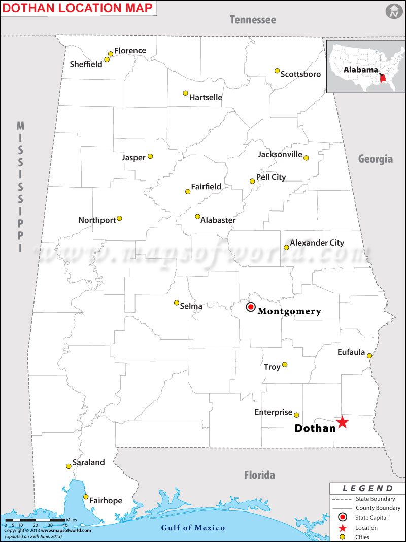
Geographically, Dothan is situated in the southeastern corner of Alabama. It functions as a regional economic and cultural center, attracting visitors and businesses from the tri-state area. Its relative isolation from major interstate highways within Alabama means that most journeys involve a mix of state routes and U.S. highways, requiring travelers to be mindful of their chosen routes and potential variations in travel time. However, this also means that the routes leading to Dothan often offer scenic drives through the heart of the Wiregrass Region, known for its agricultural landscapes.
Driving Distances from Major Hubs
For most visitors, driving is the primary mode of transport to Dothan. The city is well-connected by several U.S. routes, including U.S. Route 231, U.S. Route 84, and U.S. Route 431, which radiate out to various neighboring cities and states. Understanding the typical driving times and distances from major population centers is crucial for effective trip planning.
From Major Alabama Cities
- From Montgomery: The capital city of Alabama, Montgomery, is approximately 90–100 miles northwest of Dothan. The drive typically takes around 1 hour and 45 minutes to 2 hours, primarily via U.S. Route 231 South. This is one of the most straightforward and frequently traveled routes to Dothan.
- From Birmingham: As Alabama’s largest city, Birmingham is located roughly 190–200 miles north of Dothan. The journey usually takes between 3 hours and 30 minutes to 4 hours, involving a combination of Interstate 65 South to Montgomery, then U.S. Route 231 South.
- From Mobile: Situated on the Gulf Coast, Mobile is about 190–200 miles west of Dothan. The drive is typically around 3 hours and 30 minutes to 4 hours, primarily using U.S. Route 84 East.
- From Huntsville: In northern Alabama, Huntsville is approximately 300–310 miles from Dothan. Expect a drive of around 5 hours to 5 hours and 30 minutes, often involving U.S. Route 431 South.
From Neighboring State Capitals and Major Cities
- From Atlanta, Georgia: Dothan is a popular destination for travelers from Atlanta. The distance is approximately 190–200 miles southwest, with an average driving time of 3 hours and 30 minutes to 4 hours. The most common route involves Interstate 85 South, connecting to U.S. Route 231 South.
- From Tallahassee, Florida: As the closest state capital, Tallahassee is only about 90–100 miles southeast of Dothan. The drive takes roughly 1 hour and 45 minutes to 2 hours, typically via U.S. Route 231 North.
- From Pensacola, Florida: The popular Gulf Coast city of Pensacola is about 110–120 miles south of Dothan. The drive generally lasts around 2 hours to 2 hours and 15 minutes, often using U.S. Route 231 North.
- From New Orleans, Louisiana: New Orleans is a more considerable distance, approximately 300–310 miles west of Dothan. Expect a driving time of 5 hours to 5 hours and 30 minutes, primarily via Interstate 10 East, connecting to U.S. Route 231 North.
These estimates are subject to traffic conditions, road construction, and individual driving habits. It’s always advisable to check real-time navigation for the most accurate travel times.
Air Travel Considerations
While driving is prevalent, air travel offers a faster alternative for those coming from farther distances. Dothan is served by its own regional airport, making it accessible, albeit typically with connections.
Dothan Regional Airport (DHN)
The Dothan Regional Airport (DHN) provides commercial air service primarily through regional carriers. Currently, DHN offers daily flights to Atlanta Hartsfield-Jackson International Airport (ATL) via Delta Connection and to Charlotte Douglas International Airport (CLT) via American Eagle. These connections link Dothan to a global network of destinations, making it possible to fly into the city from virtually anywhere with a single layover.

- From Atlanta (ATL): Flights from Atlanta to Dothan are frequent and short, usually lasting around 45 minutes to 1 hour in the air. This makes ATL a convenient hub for travelers flying to Dothan.
- From Charlotte (CLT): Flights from Charlotte to Dothan typically take around 1 hour and 15 minutes to 1 hour and 30 minutes in the air, providing another viable connection point for travelers from the eastern United States.
For those requiring international connections or preferring direct flights from other major U.S. cities, flying into a larger airport and then driving to Dothan might be an option.
Alternative Major Airports
- Northwest Florida Beaches International Airport (ECP): Located near Panama City Beach, Florida, ECP is approximately 70 miles south of Dothan. The drive from ECP to Dothan is typically around 1 hour and 15 minutes. ECP offers connections to various cities through carriers like Southwest Airlines, American Airlines, and United Airlines.
- Tallahassee International Airport (TLH): About 90 miles southeast of Dothan, TLH is another alternative, offering a drive of roughly 1 hour and 45 minutes to Dothan.
When considering air travel, factor in not only flight times but also transit to and from airports, security wait times, and the potential for layovers. For shorter distances, the total travel time by car might be comparable to or even less than flying, especially when driving directly.
Planning Your Journey to Dothan
Effective travel planning ensures a smooth and enjoyable trip to Dothan. Whether you opt for a road trip or air travel, several factors should influence your preparation.
Road Trip Essentials
For those embarking on a drive to Dothan, consider these points:
- Route Planning: Utilize GPS and mapping applications (Google Maps, Waze) to identify the most efficient and up-to-date routes. Be prepared for stretches on U.S. highways rather than interstates, which may have lower speed limits and more local traffic.
- Breaks and Fuel: Plan for regular breaks, especially on longer drives, to combat fatigue. Note the locations of gas stations and rest stops, particularly in rural areas between major towns.
- Vehicle Check: Before a long drive, ensure your vehicle is in good condition, including tire pressure, fluid levels, and general maintenance.
- Traffic Considerations: While Dothan itself doesn’t typically experience heavy metropolitan traffic, approach routes from cities like Atlanta or Birmingham can have significant rush hour congestion. Plan your departure and arrival times to avoid peak traffic windows in larger urban areas.
Booking Flights and Airport Logistics
If flying is your preferred method, keep these tips in mind:
- Advance Booking: For the best fares and availability, especially when flying into a regional airport like DHN, book your flights well in advance.
- Connection Times: When booking connecting flights through Atlanta or Charlotte, ensure adequate layover time, particularly if you are unfamiliar with the hub airport or prone to delays.
- Ground Transportation: Upon arrival at DHN, consider how you will reach your final destination in Dothan. Rental cars are available, as are taxi and ride-sharing services. Pre-booking a rental car can often save time and money.

Timing Your Visit
The time of year can also impact your travel experience:
- Weather: Dothan experiences hot, humid summers and mild winters. Spring and fall offer the most pleasant weather for travel and outdoor activities. Be prepared for potential thunderstorms during warmer months.
- Local Events: Check the local calendar for events or festivals that might affect traffic, accommodation availability, or pricing. For example, the annual National Peanut Festival draws large crowds, impacting travel logistics.
In conclusion, “how far is Dothan Alabama?” is a question with a clear answer that varies based on your starting point and chosen mode of transport. Its strategic location offers reasonable accessibility by car from major Southeastern cities and convenient air connections through its regional airport. By carefully planning your route, considering travel times, and preparing for the journey, you can ensure a smooth and efficient trip to this distinctive Alabama city.
LifeOutOfTheBox is a participant in the Amazon Services LLC Associates Program, an affiliate advertising program designed to provide a means for sites to earn advertising fees by advertising and linking to Amazon.com. Amazon, the Amazon logo, AmazonSupply, and the AmazonSupply logo are trademarks of Amazon.com, Inc. or its affiliates. As an Amazon Associate we earn affiliate commissions from qualifying purchases.