
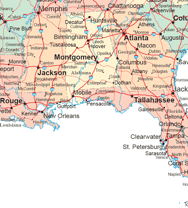
Navigating the distances between the charming states of Georgia and Alabama is a common query for travelers planning road trips, exploring regional attractions, or simply understanding the geography of the southeastern United States. While both states boast rich histories, distinct cultures, and inviting landscapes, their proximity makes them ideal for multi-state adventures. The actual “distance” is not a single number but a variable, contingent upon the specific starting and ending points within each state. This exploration will delve into the varying travel times and distances, offering insights for those looking to traverse this fascinating border region.

Understanding the Variables: Cities and Routes
The perceived distance between Georgia and Alabama is heavily influenced by the major metropolitan areas and cities one chooses to travel between. For instance, the journey from Atlanta, a bustling hub in northern Georgia, to Birmingham, a significant economic center in central Alabama, will differ considerably from a trip between the more rural southwestern tip of Georgia and the eastern edge of Alabama.
Atlanta to Birmingham: A Major Corridor
One of the most frequently traveled routes connects Atlanta, Georgia, to Birmingham, Alabama. This journey is primarily facilitated by Interstate 20 (I-20) West.
- Distance: The direct driving distance between Atlanta and Birmingham is approximately 150 miles (about 240 kilometers).
- Travel Time: Under normal traffic conditions, this route typically takes around 2.5 to 3 hours. It’s crucial to factor in potential traffic delays, especially when departing from or arriving in Atlanta during peak commuting hours or on holiday weekends.
- Interstate 20: This major artery is well-maintained and offers a relatively straightforward drive with numerous service plazas, gas stations, and dining options along the way. The landscape transitions from the rolling hills of northern Georgia to the flatter terrain of central Alabama.
Savannah to Mobile: A Coastal Perspective
For those venturing from the historic charm of Savannah, Georgia, to the port city of Mobile, Alabama, the journey is significantly longer and takes a different, more southerly path.
- Distance: The driving distance between Savannah and Mobile is roughly 350-400 miles (about 560-640 kilometers), depending on the precise route taken.
- Travel Time: This trip usually requires at least 6 to 7 hours of driving time, not including stops. The most common route involves taking I-16 West from Savannah to connect with I-10 West, which then leads into Alabama and towards Mobile.
- Interstate 10: This major east-west interstate runs along the Gulf Coast and connects several significant cities. Travelers will pass through parts of Florida along this route, making it a good option for those looking to break up the journey with a stop in a Florida Panhandle city.
Augusta to Montgomery: Exploring the Interior
Traveling between Augusta, Georgia, located on the eastern border with South Carolina, and Montgomery, Alabama, the capital of Alabama, offers a glimpse into the heart of the Deep South.
- Distance: This route covers approximately 300-320 miles (about 480-515 kilometers).
- Travel Time: The estimated driving time is around 4.5 to 5.5 hours. The route typically involves taking US-80 West or I-85 South from Montgomery to connect with various state highways and potentially I-20 West before veering south. This journey highlights the more rural stretches of both states.
Factors Affecting Travel Time
Beyond the chosen cities, several other elements can significantly influence the time it takes to travel between Georgia and Alabama. Understanding these factors can help travelers plan more accurately and avoid unexpected delays.
Traffic Conditions
As with any road trip, traffic is a paramount consideration. Major metropolitan areas like Atlanta, Birmingham, and even smaller cities on the periphery can experience significant congestion during rush hours (typically 6-9 AM and 4-7 PM on weekdays) and on weekends, especially during holidays or major events. Travelers are advised to check real-time traffic updates using navigation apps or services before and during their journey.
Road Construction and Detours

Seasonal road construction is common throughout the Southeastern United States. Sections of major interstates or state highways may be reduced to fewer lanes or experience temporary detours, leading to delays. Staying informed through local DOT websites or travel advisories can help mitigate this issue.
Weather
Severe weather, particularly during hurricane season along the coast or during tornado season in inland areas, can drastically impact travel plans. Heavy rain, thunderstorms, and high winds can slow down traffic, create hazardous driving conditions, and in extreme cases, lead to road closures. It is always advisable to check the weather forecast for both Georgia and Alabama before embarking on a trip.
Mode of Transportation
While this discussion primarily focuses on driving, other modes of transportation can also bridge the gap between these two states.
- Flying: For the longest distances, such as Savannah to Mobile, flying into regional airports like Savannah/Hilton Head International Airport and Mobile Regional Airport can save significant time, although it requires factoring in travel to and from airports, check-in, and security. Flights are often routed through major hubs like Atlanta.
- Bus and Train: While less common for direct point-to-point travel between many smaller towns, bus services (e.g., Greyhound) and Amtrak trains do connect major cities in both states. These options can be more time-consuming than driving but may offer a more relaxed travel experience for some. Amtrak routes might involve transfers and longer journey times compared to driving or flying.
Planning Your Journey: Considerations for Travelers
When planning a trip that involves traveling between Georgia and Alabama, several practical considerations can enhance the travel experience.
Border Towns and Entry Points
Both states share a significant border, and the entry points are numerous. Key crossings include:
- I-20: Connects western Georgia (near Atlanta) with eastern Alabama (near Anniston and continuing to Birmingham).
- US-80: A historic highway that runs east-west, connecting cities like Macon, Georgia with Montgomery, Alabama.
- US-27 / US-29: These highways run north-south, offering access between different regions of both states.
- I-10: The southernmost major interstate, connecting the coastal regions, particularly relevant for travel between areas near Valdosta, Georgia and Mobile, Alabama, often via Florida.
Scenic Routes and Detours
While interstates offer efficiency, the allure of a road trip often lies in exploring the landscapes and charming towns that lie off the beaten path.
- Historic US Highways: Many older US highways that predate the interstate system offer a slower, more scenic journey. These routes often wind through small towns, past historic sites, and through beautiful rural scenery. For example, traveling along sections of US-80 or US-27 can provide a more intimate experience of the Southern countryside.
- State Parks and Natural Attractions: Both Georgia and Alabama are home to numerous state parks and natural wonders. Planning detours to visit places like Cloudland Canyon State Park in Georgia or the Gulf State Park in Alabama can transform a simple drive into a rich travel experience. These detours will naturally increase the overall travel time but offer significant rewards.
Preparing for the Drive
Regardless of the chosen route, adequate preparation is key to a smooth journey.
- Vehicle Maintenance: Ensure your vehicle is in good working order, with proper tire pressure, oil levels, and a functioning air conditioning system, especially during the warm months.
- Navigation Tools: Utilize GPS devices or smartphone navigation apps, but also consider having physical maps as a backup, particularly in areas with spotty cell service.
- Snacks and Water: Carrying provisions can be helpful, especially for longer stretches between towns or during unexpected delays.
- Entertainment: Podcasts, audiobooks, and music playlists can make the drive more enjoyable.
In conclusion, the question of “How far is Georgia from Alabama?” is best answered by understanding the specific journey one intends to undertake. Whether it’s a quick hop between major cities on I-20 or a more leisurely exploration of the southern states, careful planning, awareness of potential variables, and an openness to discovery will ensure a rewarding travel experience.
LifeOutOfTheBox is a participant in the Amazon Services LLC Associates Program, an affiliate advertising program designed to provide a means for sites to earn advertising fees by advertising and linking to Amazon.com. Amazon, the Amazon logo, AmazonSupply, and the AmazonSupply logo are trademarks of Amazon.com, Inc. or its affiliates. As an Amazon Associate we earn affiliate commissions from qualifying purchases.