
Embarking on a journey across the vast and diverse landscapes of Nevada is an experience unlike any other, connecting the electrifying energy of Las Vegas with the rugged charm of Reno. Often referred to as “Sin City” and “The Biggest Little City in the World” respectively, these two iconic destinations anchor the north and south of the Silver State. While both offer a vibrant blend of entertainment, dining, and outdoor adventure, their individual personalities are distinct, making the transition between them a fascinating travel proposition.
The question of “how far” between Las Vegas and Reno isn’t just about a number of miles; it’s an invitation to explore the diverse geography, hidden gems, and varied travel options that define this significant Nevada traverse. Whether you’re seeking the quickest path, a scenic road trip adventure, or an aerial shortcut, understanding the distance and the implications for your journey is the first step in planning an unforgettable Nevada experience. This comprehensive guide will navigate the different routes, transportation methods, and essential considerations to bridge the gap between these two dynamic cities, ensuring your travel is as smooth and enjoyable as the destinations themselves.
The Direct Route: Distance, Driving Time, and Essentials
For many travelers, the most practical and popular way to travel from Las Vegas to Reno is by car. The direct drive offers flexibility and the freedom to explore at your own pace, though the journey itself is a substantial one through some of Nevada’s most expansive and sparsely populated regions. Understanding the mileage, typical driving duration, and the primary roadways is crucial for efficient planning.
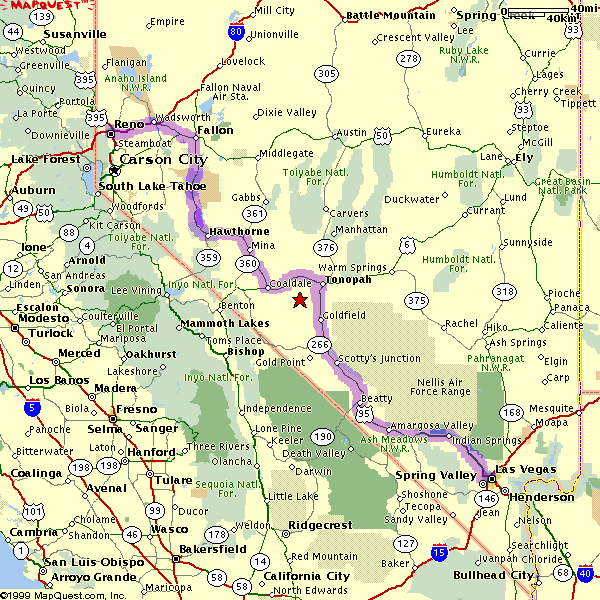
The most common and direct driving route spans approximately 440 to 450 miles (708 to 724 kilometers), depending on your exact starting and ending points within each city. This significant distance translates into a driving time that typically ranges from 7 to 8 hours without significant stops, though factoring in fuel, food, and rest breaks, it’s more realistic to expect a journey of 9 to 10 hours. This makes it a substantial day trip or, for those who prefer a more leisurely pace, a comfortable two-day drive.
Key Highways: Navigating the Nevada Desert
The primary artery connecting Las Vegas and Reno is US-95. This highway offers a relatively straight shot north through the heart of Nevada’s high desert, providing a largely uneventful but often mesmerizing drive across vast, open landscapes. From Las Vegas, you’ll head north on US-95 through towns like Tonopah and Hawthorne, eventually connecting with Interstate 80 (I-80) just east of Reno near Fallon. From there, a short drive west on I-80 brings you directly into the city center.
While US-95 is a well-maintained highway, it passes through many remote areas with limited services. Travelers should ensure their vehicle is in good condition, fuel up whenever possible, and carry plenty of water and snacks. Cell service can be spotty in certain stretches, so downloading offline maps is a wise precaution. The scenery, while minimalist, can be captivating, featuring expansive skies, distant mountain ranges, and unique desert flora.
Factors Affecting Travel Time
Several elements can influence your overall travel time. Beyond the obvious stops for essentials, traffic, although generally light on US-95, can build up closer to both Las Vegas and Reno, particularly during peak rush hours or around holidays. Construction projects, though usually well-marked, can also cause minor delays. Weather is another significant factor, especially during winter months, when snow and ice can impact road conditions, particularly closer to Reno and the surrounding Sierra Nevada Mountains. Always check weather and road conditions before embarking on your journey, especially if traveling outside of summer. Allowing for buffer time in your schedule ensures a relaxed and stress-free drive.
Scenic Alternatives and Road Trip Adventures
While the direct route on US-95 is efficient, for those with more time and a desire to experience the stunning natural beauty of the American West, several scenic alternatives transform the drive into an unforgettable road trip. These routes often involve slightly longer distances and driving times but reward travelers with breathtaking landscapes, unique geological formations, and charming small towns.
One of the most popular and awe-inspiring scenic detours involves heading west into California and following US-395, also known as the Eastern Sierra Scenic Byway. This route adds significant mileage, bringing the total distance to around 550-600 miles (885-965 kilometers) and extending driving time to 9-11 hours, not including stops. However, the views of the Sierra Nevada Mountains and the diverse attractions along the way make it well worth the extra effort.
Exploring the Eastern Sierra Scenic Byway (US-395)
To take the US-395 route, you would initially drive west from Las Vegas on SR-160 or SR-190, eventually connecting with US-395 in California. This road then winds its way north through the Owens Valley, with the dramatic eastern wall of the Sierra Nevada Mountains rising majestically to the west. This route is typically considered a two-day journey to allow ample time for exploration and enjoyment of its many wonders.
Must-See Stops Along the Way
The Eastern Sierra Scenic Byway is dotted with incredible natural and historical sites:
- Death Valley National Park: Although a slight detour from the most direct path to US-395, this iconic park is accessible from the Las Vegas area and offers an unparalleled desert experience with stunning badlands, salt flats, and sand dunes. It’s a worthy overnight stop itself.
- Mono Lake: A saline soda lake renowned for its unique “tufa towers” – limestone formations that rise from the water. It’s a surreal landscape and a haven for migratory birds.
- Mammoth Lakes: A popular resort town offering year-round outdoor activities, including skiing in winter and hiking, fishing, and mountain biking in summer. It’s an excellent place for an overnight stay or a meal.
- Bishop and Lone Pine: Charming towns that serve as gateways to incredible hiking and climbing in the Sierra Nevada Mountains, including Mount Whitney, the highest peak in the contiguous United States.
- Lake Tahoe: As you near Reno, a slight detour to the west will bring you to the breathtaking shores of Lake Tahoe. This pristine alpine lake, straddling the California-Nevada border, offers crystal-clear waters, sandy beaches, and world-class skiing. Spending a night here or simply driving around its circumference is a highlight of any trip to the region.
Planning Your Overnight Stays
Given the length and the multitude of attractions, planning an overnight stop is highly recommended for the scenic route. Popular towns for overnight stays include Bishop, Mammoth Lakes, or Lee Vining (near Mono Lake). These towns offer a range of accommodations, dining options, and access to local attractions, allowing you to break up the drive and fully immerse yourself in the natural beauty of the region. This approach transforms a long drive into a memorable multi-day exploration.

Beyond the Wheel: Other Transportation Options
While driving offers unparalleled flexibility and the chance to explore Nevada’s vast landscapes, it’s not the only way to travel between Las Vegas and Reno. For those seeking speed, comfort, or simply a break from driving, several alternative transportation methods are available, each with its own advantages and considerations.
Flying Between Las Vegas and Reno
The quickest way to bridge the distance between these two cities is by air. Direct flights between Harry Reid International Airport (LAS) in Las Vegas and Reno-Tahoe International Airport (RNO) are readily available. The flight itself is remarkably short, typically lasting just over an hour, making it the most time-efficient option.
Airlines like Southwest Airlines, Allegiant Air, and Frontier Airlines frequently offer direct routes, providing various choices for travelers. While the flight time is minimal, remember to factor in the entire travel experience: getting to and from the airports, security checks, boarding, and potential delays. All told, the door-to-door travel time for flying can still amount to 3-5 hours, depending on airport efficiency and proximity to your accommodations. Nevertheless, for business travelers or those with limited time, flying remains the most practical solution.
Bus Services
For budget-conscious travelers or those who prefer to sit back and enjoy the ride without the responsibilities of driving, bus services offer a viable option. Companies like Greyhound provide routes connecting Las Vegas and Reno. The bus journey typically follows the direct US-95 route and makes several stops along the way, increasing the overall travel time.
A bus trip from Las Vegas to Reno can take anywhere from 9 to 12 hours, depending on the specific schedule, number of stops, and road conditions. While it’s a longer journey than driving your own car, it allows passengers to relax, read, or work without the fatigue of driving. Tickets are generally affordable, making it an attractive option for those prioritizing cost savings over speed. It’s advisable to book tickets in advance, especially during peak travel seasons, and to check the bus line’s baggage policies.
Train Travel: A Limited Option
Unlike many other regions, direct train travel between Las Vegas and Reno is not a straightforward option. While Amtrak serves Reno via the California Zephyr route (which runs from Chicago to Emeryville, California), Las Vegas does not have direct Amtrak service. To travel by train, one would typically need to take a bus from Las Vegas to a connecting Amtrak station in California (e.g., Bakersfield or Los Angeles) and then transfer to a different route that eventually reaches Reno. This convoluted journey makes train travel highly impractical and significantly longer than any other option, often extending to 24 hours or more with transfers. Therefore, for most travelers, the train is not a recommended mode of transport for this specific route.
Preparing for Your Nevada Journey
Regardless of whether you choose the quick flight or the adventurous road trip, preparing adequately for your journey from Las Vegas to Reno is essential for a smooth and enjoyable experience. Nevada’s diverse climate and vast, open spaces demand a certain level of foresight, especially for those opting to drive.
Best Time to Travel
The ideal time to travel between Las Vegas and Reno largely depends on your priorities. Spring (April-May) and Fall (September-October) generally offer the most pleasant driving conditions. Temperatures are moderate, making outdoor stops enjoyable, and the risk of extreme weather (scorching summer heat or winter snow) is lower. During these shoulder seasons, the desert blooms in spring, and fall foliage (particularly along the Eastern Sierra Scenic Byway or around Lake Tahoe) can be stunning.
Summer (June-August) brings intense heat to the Nevada desert, with temperatures often exceeding 100°F (38°C). While manageable, it requires extra precautions, such as carrying abundant water, checking vehicle fluids, and planning stops during the hottest parts of the day. Winter (November-March) can see snow and ice, especially in the higher elevations near Reno and along the Sierra Nevada Mountains. If traveling during winter, be prepared for potential road closures or delays due to weather, and ensure your vehicle is equipped for snowy conditions (e.g., chains or snow tires might be required on certain mountain passes).
Vehicle Preparation and Essentials for Road Trips
For those driving, a thorough vehicle check-up before departure is highly recommended. This includes inspecting tires (including the spare), checking fluid levels (oil, coolant, windshield wiper fluid), and ensuring lights and wipers are in working order. Given the long stretches between services on US-95, it’s crucial to start with a full tank of gas and refuel whenever the opportunity arises.
Essential items to pack for a Nevada road trip include:
- Plenty of water and non-perishable snacks: Crucial for hydration and energy, especially in remote areas.
- First-aid kit: For minor injuries or emergencies.
- Emergency road kit: Jumper cables, a flashlight, basic tools, and reflective triangles.
- Physical maps or downloaded offline maps: Cell service can be unreliable in parts of the desert.
- Sun protection: Sunscreen, hats, and sunglasses are vital year-round.
- Warm layers: Even in the desert, temperatures can drop significantly after sunset, particularly at higher elevations.
- Portable charger: For phones and other electronics.
Navigating Desert Conditions and Wildlife
Driving through Nevada’s desert landscapes offers unique challenges and beauty. Be mindful of dust storms, which can reduce visibility dramatically; if one occurs, slow down, turn on your headlights, and pull over safely if visibility becomes too low. Wildlife crossings, particularly at dawn and dusk, are also a consideration. Keep an eye out for deer, wild horses, and other animals that may stray onto the road. Long stretches of highway can lead to driver fatigue, so plan regular breaks to stretch, refresh, and maintain alertness.
By taking these preparations into account, your journey from the neon glow of Las Vegas to the mountain charm of Reno will be not just a transition between destinations, but an integral and enjoyable part of your overall Nevada travel adventure.
LifeOutOfTheBox is a participant in the Amazon Services LLC Associates Program, an affiliate advertising program designed to provide a means for sites to earn advertising fees by advertising and linking to Amazon.com. Amazon, the Amazon logo, AmazonSupply, and the AmazonSupply logo are trademarks of Amazon.com, Inc. or its affiliates. As an Amazon Associate we earn affiliate commissions from qualifying purchases.