
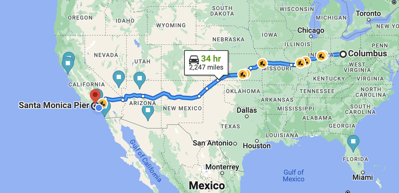
This is the central question for anyone contemplating a cross-country journey from the Midwest to the West Coast. The distance between Ohio and California is substantial, spanning the breadth of the continental United States and presenting a significant undertaking whether you choose to drive, fly, or take a train. Understanding the exact mileage, travel time, and logistical considerations is paramount for planning a successful and enjoyable trip.
The Grand Traverse: Understanding the Distance
Embarking on a journey from the heartland of Ohio to the diverse landscapes of California means traversing thousands of miles. This transcontinental voyage is more than just a measurement of distance; it’s a passage through varied terrains, climates, and time zones.
Geographical Overview: Ohio and California
Ohio, situated in the Midwest region, is known for its industrial heritage, fertile farmlands, and major cities like Columbus, Cleveland, and Cincinnati. It borders Lake Erie to the north and is a gateway to the eastern and central United States. On the opposite side of the country lies California, a vast state stretching along the Pacific Coast. It encompasses everything from the bustling metropolises of Los Angeles and San Francisco to the serene deserts of Mojave, towering peaks of the Sierra Nevada mountains, and the lush vineyards of Napa Valley. The sheer geographical contrast underscores the scale of the journey.
Measuring the Miles: Average Road Distances
The precise distance between Ohio and California depends heavily on your specific starting point in Ohio and your destination in California. For instance, a trip from Cleveland, Ohio, to Los Angeles, California, typically covers around 2,400 to 2,500 miles (approximately 3,860 to 4,020 kilometers). If your destination is San Francisco, the distance might increase slightly to about 2,500 to 2,600 miles (4,020 to 4,180 kilometers) from Cleveland. From Cincinnati, Ohio, to Los Angeles, the distance is roughly similar, perhaps a little less at 2,200 to 2,300 miles. These figures represent the most direct routes, primarily utilizing interstates, which offer the quickest travel times. Deviations for scenic routes or specific attractions will, of course, add to the total mileage.
Time Commitment: Driving Hours and Stopovers
Driving the entire distance in one go is generally impractical and unsafe. For an average driver, covering 500-600 miles in a day is a significant undertaking. Based on typical driving speeds and minimal stops, the actual driving time alone will range from 36 to 45 hours, depending on the route and destination. To complete this journey safely and enjoyably, it’s highly recommended to break it up into at least 4 to 5 days. This allows for adequate rest, time to explore points of interest along the way, and avoids driver fatigue. Factoring in overnight stays, meals, and short breaks, a cross-country drive from Ohio to California typically takes anywhere from 4 to 7 days, providing a realistic timeframe for planning.
Modes of Transport: Choosing Your Journey
The choice of transportation from Ohio to California profoundly impacts your experience, budget, and time commitment. Each mode offers distinct advantages and disadvantages, catering to different travel preferences.
Driving: The Classic American Road Trip
The allure of the open road is undeniable, and a cross-country drive from Ohio to California embodies the quintessential American road trip. This option offers unparalleled flexibility and the opportunity to discover hidden gems along the way.
Route Considerations
Several major interstate highways connect the Midwest to the West Coast.
- Interstate 80 (I-80): This northern route cuts across Ohio and continues through Indiana, Illinois, Iowa, Nebraska, Wyoming, Utah, and Nevada before reaching California. It’s a popular choice for those heading to Northern California cities like San Francisco.
- Interstate 70 (I-70) and Interstate 15 (I-15): A central option involves taking I-70 through Missouri, Kansas, and Colorado to Denver, then connecting to I-15 which traverses Utah, Arizona, and Nevada directly into Southern California. This route offers stunning mountain vistas.
- Interstate 40 (I-40): For a more southern trajectory, I-40 (often accessed via I-70 or I-44) runs through Oklahoma, Texas, New Mexico, and Arizona before meeting up with other interstates to reach California. This is ideal for those interested in the Southwest desert landscapes and accessing Southern California.
Vehicle Preparation and Budgeting
Before setting out, ensure your vehicle is in top condition. A pre-trip inspection of tires, brakes, fluids, and belts is crucial. Budgeting for fuel, especially with fluctuating gas prices, is essential. Expect to spend several hundred dollars on gasoline alone. Factor in costs for accommodation, food, and potential emergency repairs.
Flying: Speed and Convenience
For those prioritizing speed and minimizing travel time, flying is the most efficient option. What takes days by car can be accomplished in a matter of hours by air.
Major Airports and Booking Tips
Major airports in Ohio include Cleveland Hopkins International Airport (CLE), John Glenn Columbus International Airport (CMH), and Cincinnati/Northern Kentucky International Airport (CVG). On the California side, primary hubs are Los Angeles International Airport (LAX), San Francisco International Airport (SFO), and San Diego International Airport (SAN). Direct flights from Ohio to California are common, with flight times typically ranging from 4.5 to 6 hours. Booking flights in advance, especially during off-peak seasons, can yield significant savings. Be flexible with your travel dates and consider flying on weekdays for potentially lower fares.
Time Savings vs. Cost
While flying offers substantial time savings, it often comes at a higher monetary cost, especially when accounting for baggage fees, airport transfers, and potentially rental cars at your destination. However, the trade-off of less wear and tear on your own vehicle and avoiding multiple overnight stays can make it a cost-effective choice for some.
Train and Bus: Scenic and Budget-Friendly Alternatives
For a more relaxed pace or budget-conscious travelers, trains and buses present viable alternatives.
Amtrak Routes
Amtrak, the national passenger rail service, offers cross-country routes that provide a unique travel experience. From Ohio, you would typically connect to major Amtrak lines like the California Zephyr (running from Chicago to Emeryville/San Francisco via Denver and Salt Lake City) or the Southwest Chief (from Chicago to Los Angeles via Kansas City and Albuquerque). Train journeys are considerably longer than driving, often taking 2 to 3 days, but they allow passengers to enjoy scenic landscapes without the stress of driving.
Greyhound Services
Greyhound and other bus services offer the most economical option for long-distance travel. The journey will be the longest, potentially taking 3 to 4 days with numerous stops and transfers. While less comfortable than flying or driving, it’s a practical choice for travelers on a tight budget.
Planning Your Cross-Country Adventure
Regardless of your chosen mode of transportation, meticulous planning is the cornerstone of a successful trip from Ohio to California. Consideration of routes, timing, and packing ensures a smooth and memorable journey.
Essential Road Trip Stops and Scenic Diversions
If you opt for the classic American road trip, the beauty lies in the journey itself. Breaking up the drive with strategic stops not only offers rest but also enriches your travel experience.

Midwest Highlights
Departing from Ohio, you’ll pass through several vibrant Midwest cities. Chicago, Illinois, makes for an excellent first major stop, offering world-class museums, architecture, and dining. Further west, St. Louis, Missouri, is home to the iconic Gateway Arch National Park, a must-see landmark.
Mountain West Majesty
As you head into the Mountain West, cities like Denver, Colorado, serve as excellent bases for exploring the Rocky Mountains. Further west, Salt Lake City, Utah, offers a unique cultural experience and access to stunning natural parks.
Southwest Desert Wonders
The Southwest leg of your journey can include iconic stops like Las Vegas, Nevada, for entertainment, or the awe-inspiring Grand Canyon National Park in Arizona, a detour well worth the extra miles. Other possibilities include Zion National Park or Bryce Canyon National Park in Utah.
Best Time to Travel
The timing of your trip can significantly affect road conditions, crowd levels, and overall enjoyment.
Seasonal Considerations
Spring (April-May) and Fall (September-October) are generally considered the best times for a cross-country drive. The weather is milder, reducing the risk of extreme heat in the deserts or heavy snow in the mountains. Summers can be excessively hot, especially in the Southwest, and winters can present treacherous driving conditions due to snow and ice across the northern states and mountain passes.
Avoiding Peak Times
Holiday weekends and summer vacation periods often mean increased traffic, higher prices for accommodations, and more crowded attractions. If possible, travel during the shoulder seasons to enjoy a more relaxed and cost-effective experience.
Packing Smart for a Long Journey
What you pack depends on your mode of transport, but some essentials are universal.
Road Trip Essentials
For drivers, a comprehensive emergency kit (jumper cables, first-aid, flashlight, basic tools), plenty of water, non-perishable snacks, and entertainment for passengers are crucial. Download offline maps, have a reliable GPS, and ensure your phone is charged. Comfortable clothing suitable for varying climates is also important.
Luggage for Air Travel
If flying, adhere strictly to airline baggage weight and size restrictions to avoid unexpected fees. Pack light and efficiently, focusing on versatile clothing items. Consider what you’ll need immediately upon arrival if your luggage is delayed.
Arriving in California: Initial Considerations
Upon reaching the Golden State, your travel planning doesn’t end. California is immense and diverse, requiring specific considerations for navigating its regions and making the most of your arrival.
Northern California vs. Southern California Destinations
California is roughly divided into Northern California and Southern California, each offering distinct attractions and experiences. Your choice of destination will influence your final route and local travel.
Coastal Beauty and Urban Charm
In Northern California, San Francisco stands out with its iconic Golden Gate Bridge, historic cable cars, and vibrant neighborhoods. Nearby, the coastal town of Monterey offers stunning ocean views and the renowned Monterey Bay Aquarium. This region is often characterized by its cooler climate and rugged coastline.
Urban Expanse and Sunny Beaches
Southern California boasts the sprawling metropolis of Los Angeles, famous for Hollywood, world-class entertainment, and beautiful beaches like Malibu and Santa Monica. Further south, San Diego offers a more laid-back atmosphere, pristine beaches, and attractions like Balboa Park and the San Diego Zoo. The climate here is generally warmer and sunnier.
Natural Wonders
Beyond the cities, California is home to incredible natural beauty. Yosemite National Park in the Sierra Nevada is a global icon for its granite cliffs and waterfalls, while Lake Tahoe, straddling the California-Nevada border, is a stunning alpine lake destination for both summer and winter activities.
Local Transportation Upon Arrival
Once you’ve reached your California destination, consider how you’ll get around.
Rental Cars
Given the vastness of California and the dispersed nature of many attractions, renting a car is often the most practical option, especially if you plan to explore beyond major city centers. Book well in advance, particularly during peak travel seasons, to secure the best rates and availability.

Public Transit
Major California cities like San Francisco and Los Angeles have extensive public transportation networks. San Francisco’s BART (Bay Area Rapid Transit) and Muni systems are efficient for navigating the city and surrounding Bay Area. Los Angeles has the Metro Rail and bus system, though its sprawling nature means public transit can be time-consuming for certain routes. Ridesharing services (Uber, Lyft) are also widely available.
The journey from Ohio to California is an epic undertaking that promises unforgettable experiences. By carefully planning your route, choosing the right mode of transport, and accounting for the numerous details involved, you can transform a daunting distance into a seamless and exciting adventure.
LifeOutOfTheBox is a participant in the Amazon Services LLC Associates Program, an affiliate advertising program designed to provide a means for sites to earn advertising fees by advertising and linking to Amazon.com. Amazon, the Amazon logo, AmazonSupply, and the AmazonSupply logo are trademarks of Amazon.com, Inc. or its affiliates. As an Amazon Associate we earn affiliate commissions from qualifying purchases.