
Determining how far Rochester is depends entirely on your starting point, your chosen mode of transportation, and the route you prefer to take across the diverse landscape of the United States. Nestled along the southern shore of Lake Ontario in the Finger Lakes region of New York, this city serves as a hub of history, innovation, and scenic beauty. Whether you are planning a cross-country road trip or a quick regional getaway, understanding the logistics of reaching this destination is the first step toward a successful journey.
Geographical Proximity and Major Driving Routes
The distance to Rochester is defined by the dense network of interstate highways that crisscross the Northeast. For those traveling within the Mid-Atlantic or New England regions, the drive is often manageable within a single day.
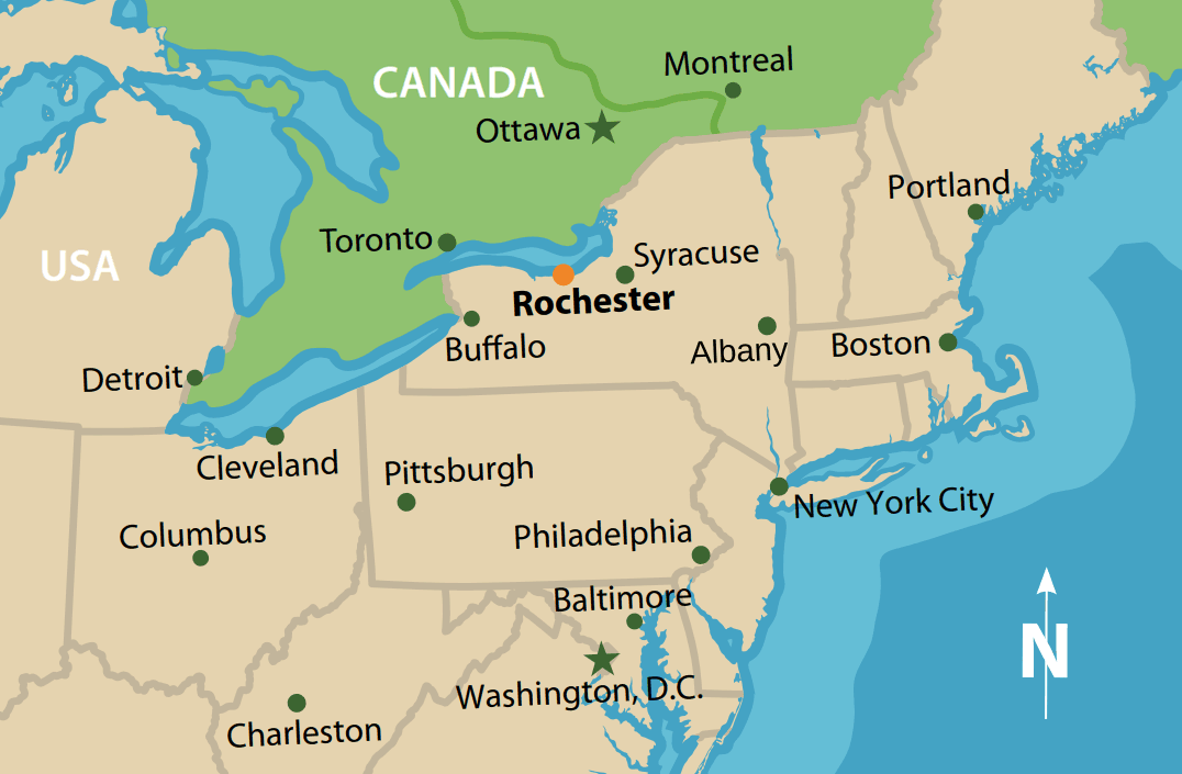
Traveling from Major Northeastern Cities
When departing from New York City, travelers can expect a journey of approximately 330 miles. Depending on traffic congestion through the Hudson Valley and across the Catskill Mountains, this route typically takes between five and six hours via I-81 and I-90. The drive offers glimpses of some of the most historic terrain in the country.
If your point of origin is Boston, the distance spans roughly 360 miles. Following the I-90 West corridor through Massachusetts and Upstate New York, you will pass through the scenic Berkshires before arriving in the city. Conversely, coming from Philadelphia or Washington D.C., the journey involves traversing the mountainous regions of Pennsylvania, leading to a drive that generally ranges between six to eight hours.
Crossing from the Midwest and Canada
For those traveling from the Midwest, Rochester serves as a logical stopping point after passing through Buffalo. From Cleveland, the drive is approximately 250 miles, mostly tracking along the Erie Canal corridor. International travelers arriving from Toronto have a relatively short trek, spanning about 180 miles around the western edge of Lake Ontario, necessitating a border crossing at the Niagara River.
Air Travel and Connectivity
If driving is not your preferred method, the city is well-served by regional and national aviation networks. The primary gateway for air travelers is the Frederick Douglass Greater Rochester International Airport.
Navigating the Airport
The airport acts as the central node for incoming domestic flights. While it does not function as a massive international hub, it maintains consistent connectivity with major metropolitan airports in Chicago, Atlanta, and Charlotte. Travelers can effectively utilize these hubs to minimize total travel time.
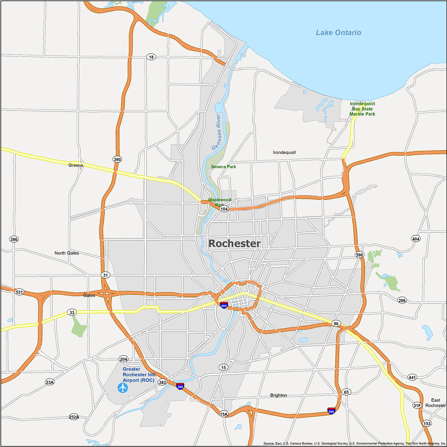
Ground Transportation from the Terminal
Once you touch down, the distance from the airport to the city center is minimal—roughly seven miles. This short commute is easily bridged by ride-sharing services, rental cars, or local transit options. The strategic location of the Frederick Douglass Greater Rochester International Airport ensures that visitors spend less time in transit and more time enjoying the local culture.
Rail and Bus Options
For those who prefer to avoid the stresses of traffic and parking, the Amtrak rail service offers a scenic and reliable alternative.
The Amtrak Experience
The Rochester Amtrak Station is located on the Empire Service line, connecting New York City to Buffalo and Niagara Falls. This rail route is particularly popular for its views of the Mohawk Valley and the rural landscapes of New York. While rail travel is often slower than driving, it provides a unique opportunity to relax and take in the changing topography of the state.
Bus Travel
Long-distance bus carriers provide affordable connectivity to the region. Terminals within the city serve as arrival points for travelers coming from neighboring states, making it a viable option for those adhering to a stricter budget. Although bus travel time can be variable due to road conditions, it remains a consistent link for regional commuters.
Planning Your Arrival for Optimal Experience
Understanding how far Rochester is constitutes only part of the travel equation. The experience of the journey itself can be vastly improved by considering timing and seasonal variations.
Seasonal Impacts on Travel Time
The Northeast experiences significant weather fluctuations. In the winter months, travel times on I-90 can be impacted by lake-effect snow, particularly as you approach the Great Lakes area. Travelers should always check local weather reports and the status of the New York State Thruway during the colder months.
Spring, summer, and autumn provide the most stable driving conditions, with autumn being particularly noteworthy for the vibrant foliage displays along the routes leading into Upstate New York.

Maximizing Your Visit
Once you have determined the distance and method of travel, it is essential to consider the proximity of your accommodations to the points of interest. Whether your goal is to visit the Strong National Museum of Play or to explore the historical significance of the Susan B. Anthony House, knowing the layout of the city will save you precious time.
The city is designed with a relatively accessible road network, allowing for quick transit between the University of Rochester area, the Park Avenue neighborhood, and the waterfront activities at Charlotte Beach. By mapping out your distance from these key landmarks, you can curate an itinerary that minimizes travel fatigue and maximizes your time exploring one of the most culturally rich regions of the Eastern United States.
LifeOutOfTheBox is a participant in the Amazon Services LLC Associates Program, an affiliate advertising program designed to provide a means for sites to earn advertising fees by advertising and linking to Amazon.com. Amazon, the Amazon logo, AmazonSupply, and the AmazonSupply logo are trademarks of Amazon.com, Inc. or its affiliates. As an Amazon Associate we earn affiliate commissions from qualifying purchases.