
The border between Texas and Mexico is a significant geographical and geopolitical feature, stretching across a diverse range of landscapes and impacting numerous communities. Understanding its length is crucial for grasping its scale, the implications for travel, trade, and security, and the sheer vastness of the territory it defines. This extensive frontier is not a single, easily measured line, but rather a complex boundary that has evolved over centuries, shaped by natural forces and human endeavors.
The Geographical Extent of the Texas-Mexico Frontier
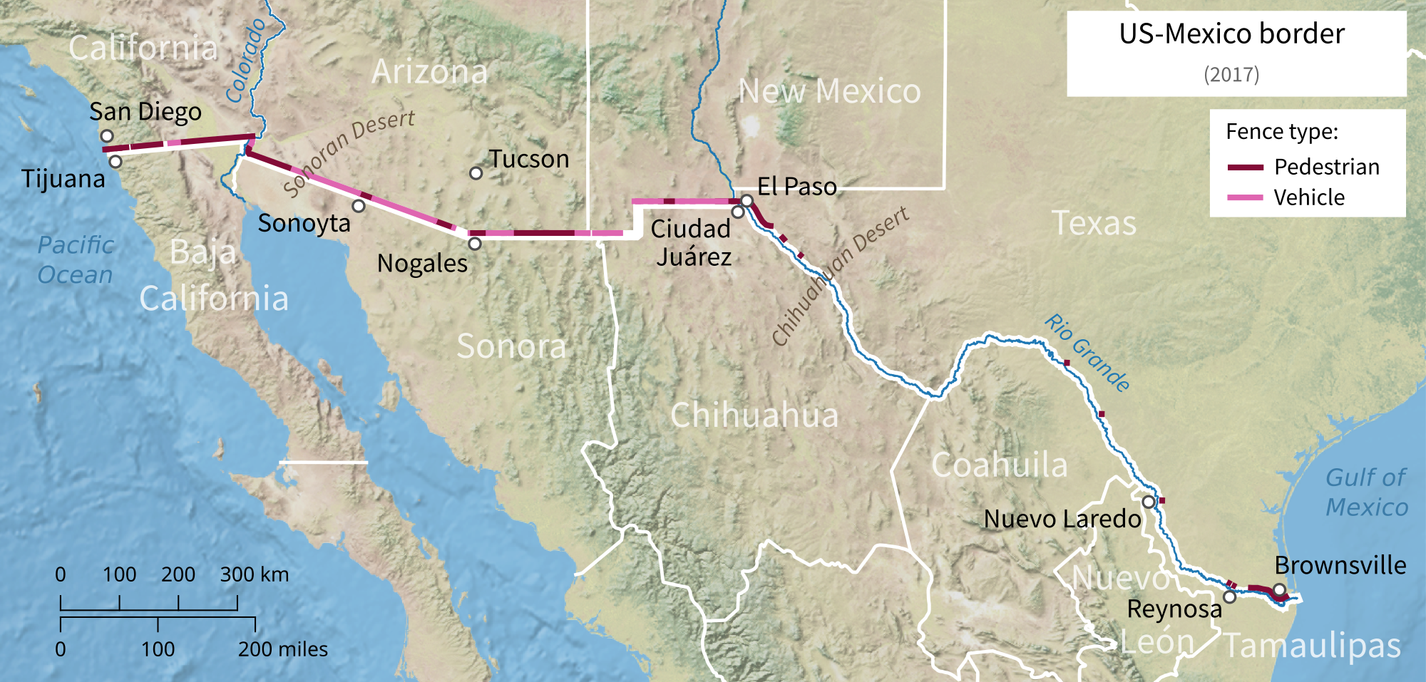
The Texas-Mexico border is primarily defined by the course of the Rio Grande (Río Bravo del Norte in Mexico). This mighty river, a vital water source and a natural barrier, dictates the majority of the border’s path. However, the river’s course is not static, and its meanders and shifts over time have influenced historical and contemporary interpretations of the exact border demarcation.
Defining the Border: The Rio Grande’s Role
The Rio Grande originates in the San Juan Mountains of Colorado and flows southeast for approximately 1,900 miles (3,060 kilometers) before emptying into the Gulf of Mexico. A substantial portion of this course serves as the international boundary between the United States and Mexico. For Texas, this means that the river itself is the border for hundreds of miles.
The exact length of the border as demarcated by the Rio Grande is subject to interpretation and depends on how one measures the river’s winding path. However, official sources and geographical surveys place the total length of the border between Texas and Mexico at roughly 1,254 miles (2,019 kilometers). This figure represents the total length of the international boundary, incorporating both the riverine section and any terrestrial sections where the boundary deviates from the Rio Grande.
Terrestrial and Historical Nuances
While the Rio Grande forms the most significant part of the border, there are sections where the boundary is defined by surveyed lines on land. These terrestrial segments are often remnants of historical treaties and agreements, particularly in areas where the river’s course has shifted dramatically, leading to disputes and subsequent border adjustments. The International Boundary and Water Commission (IBWC), established in 1889, plays a crucial role in maintaining the boundary and resolving issues related to the river’s flow and the border’s demarcation.
The historical context is also vital. The current border is a result of the Mexican-American War (1846-1848) and the subsequent Treaty of Guadalupe Hidalgo, which ceded a vast territory from Mexico to the United States. The Gadsden Purchase in 1854 further defined the southern border of Arizona and New Mexico, indirectly influencing the perception and administration of the entire southern border.
Experiencing the Texas-Mexico Borderlands
The immense length of the Texas-Mexico border translates into a region of remarkable diversity, offering unique travel experiences, cultural encounters, and a glimpse into a complex geopolitical reality. From arid desert landscapes to fertile river valleys, the borderlands present a tapestry of natural beauty and human settlement.
Crossing Points and Border Cities

Numerous cities and towns dot the Texas side of the border, each with its distinct character and offering various points of entry into Mexico. Popular crossing points include El Paso/Juárez, Laredo/Nuevo Laredo, and Brownsville/Matamoros. These sister cities, separated by the Rio Grande, are hubs of commerce, culture, and cross-border interaction.
Travelers can experience the vibrant blend of American and Mexican influences in the cuisine, music, and art of these border towns. Exploring local markets, enjoying authentic Tex-Mex and traditional Mexican dishes, and visiting historical sites that tell the story of the region are all part of the border experience.
Natural Attractions Along the Frontier
Beyond the urban centers, the Texas-Mexico border is framed by stunning natural landscapes. The Chihuahuan Desert, encompassing much of West Texas, offers rugged beauty, unique flora and fauna, and opportunities for hiking and stargazing. Parks like Big Bend National Park provide unparalleled access to the dramatic canyons and remote wilderness along the Rio Grande.
Further east, the landscape transitions to rolling hills and subtropical vegetation. The coastal areas near the Gulf of Mexico offer a different kind of natural beauty, with diverse ecosystems and opportunities for birdwatching and exploring coastal wildlife refuges. The river itself, the lifeblood of the borderlands, can be explored through boat tours, offering a unique perspective on the frontier.
The Human Element: Communities and Culture
The sheer length of the Texas-Mexico border underscores the deep and interconnected human element of this region. For centuries, communities on both sides of the border have developed shared traditions, languages, and economies, creating a unique cultural mosaic.
Intertwined Histories and Shared Identities
The border is not a rigid division but rather a permeable membrane where cultures have blended and identities have formed through a shared history. Indigenous peoples, Spanish colonizers, Mexican ranchers, and American settlers have all contributed to the rich cultural heritage of the borderlands. This heritage is evident in the architecture, the dialects, the music, and the close-knit family ties that often span the international divide.
Festivals and cultural events celebrating this shared heritage are common throughout the border region, offering visitors an authentic glimpse into the lives and traditions of its inhabitants. These events often highlight the resilience, ingenuity, and warmth of the people who call the border home.

Economic Interdependence and Trade
The length of the border also signifies a significant economic relationship. Trade and commerce flow continuously across the frontier, with numerous ports of entry facilitating the movement of goods and people. Industries such as agriculture, manufacturing, and tourism are deeply intertwined, with businesses and workers relying on cross-border cooperation.
Understanding the scale of the Texas-Mexico border is to appreciate the vast network of human interaction, natural wonders, and cultural exchanges that define this dynamic and often misunderstood region. Its considerable mileage is a testament to the enduring relationship between two nations and the unique communities that thrive along this consequential line on the map.
LifeOutOfTheBox is a participant in the Amazon Services LLC Associates Program, an affiliate advertising program designed to provide a means for sites to earn advertising fees by advertising and linking to Amazon.com. Amazon, the Amazon logo, AmazonSupply, and the AmazonSupply logo are trademarks of Amazon.com, Inc. or its affiliates. As an Amazon Associate we earn affiliate commissions from qualifying purchases.