
The journey between Boston, Massachusetts, and New York City, New York, is one of the most frequently traversed routes on the US East Coast. Whether for business, leisure, or visiting friends and family, understanding the distance and the various travel options is paramount to planning a smooth and enjoyable trip. While the exact mileage can vary slightly depending on the specific starting and ending points within each metropolitan area and the chosen route, the core distance remains consistent, influencing travel times and logistical considerations across all modes of transport.
The Direct Distance and Practical Routes
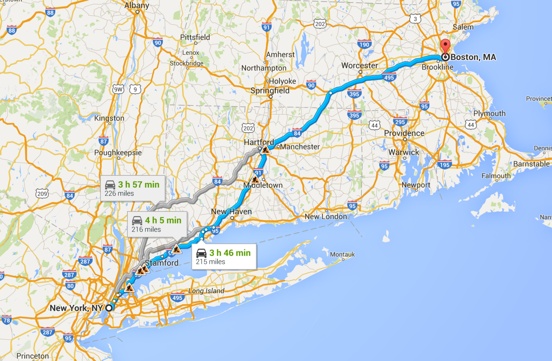
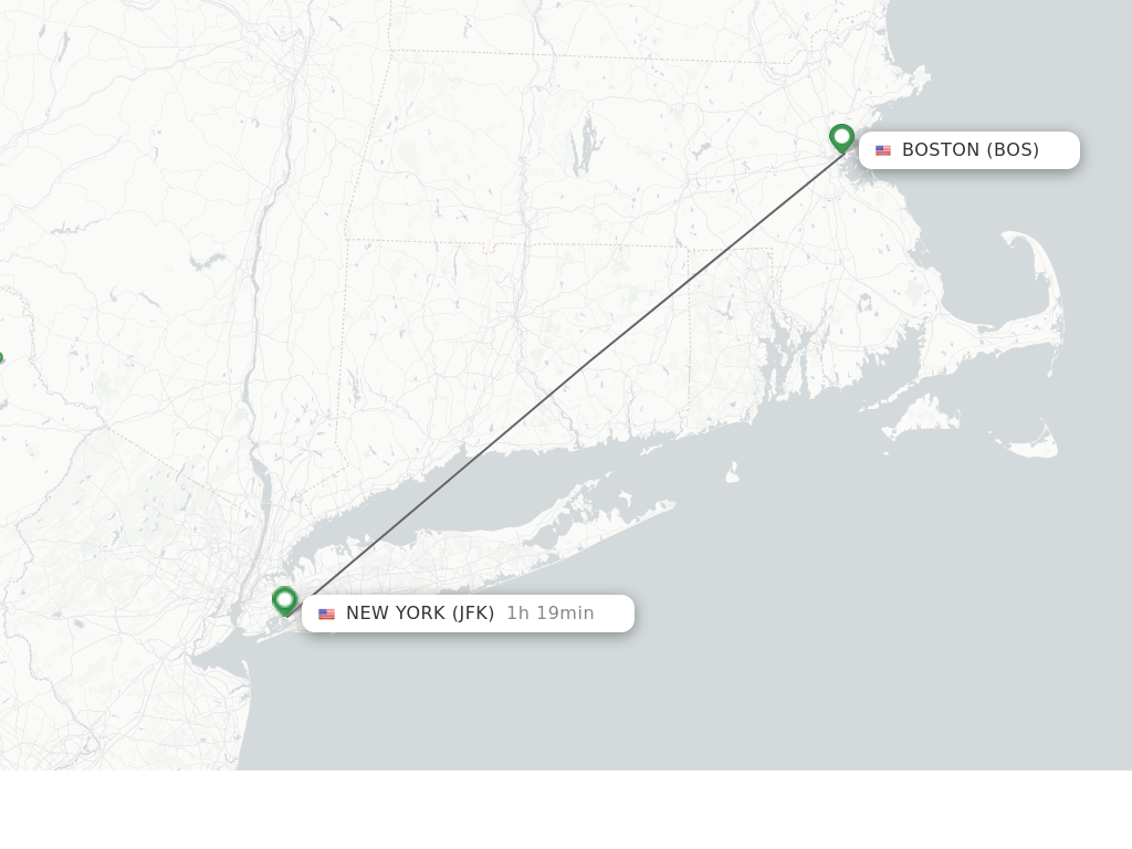
At its most direct, the aerial distance, or “as the crow flies,” between Boston and New York is approximately 190 to 200 miles (around 306-322 kilometers). However, ground travel, which accounts for the vast majority of journeys, necessarily involves following roads, rail lines, or navigable air corridors, making the practical distance longer.
Understanding the Geographical Gap
These two iconic American cities are separated by a stretch of New England and the state of Connecticut. The landscape between them is a mix of dense urban areas, charming small towns, and picturesque stretches of coastline, especially as one approaches Long Island Sound. The terrain is generally flat to rolling, presenting no significant geographical barriers that would drastically alter route choices. The journey is predominantly east-west or southwest-northeast, tracing a path along the Atlantic seaboard.
Key Interstate Highways
For road travel, the primary artery connecting Boston and New York is Interstate 95 (I-95). This major north-south highway stretches along the entire East Coast and provides the most direct and efficient driving route.
- I-95 South from Boston: Drivers typically begin by heading south out of Boston, merging onto I-95 in Massachusetts, which then carries them through Rhode Island and Connecticut. Upon reaching New York State, I-95 continues directly into the Bronx and eventually leads to various access points for Manhattan and other boroughs.
- Mileage via I-95: The driving distance via I-95 is typically around 215 to 220 miles (approximately 346-354 kilometers). This can fluctuate slightly based on specific entry and exit points in both cities.
- Alternative Routes: While I-95 is the most common, some travelers might opt for alternative routes to avoid specific traffic choke points or to enjoy different scenery. These could involve segments of Interstate 90 (the Massachusetts Turnpike) or various state highways, but they generally add mileage and travel time. For instance, combining I-90 with I-84 through central Connecticut before connecting to I-684 and then I-287 in New York can be an option, but it’s typically longer than the direct I-95 route.
Modes of Transportation and Their Implications
The choice of transportation significantly impacts the practical mileage, travel time, and overall experience of journeying between Boston and New York. Each option caters to different priorities, from speed and cost to comfort and flexibility.
Driving: Freedom and Flexibility
Driving offers the most flexibility, allowing for spontaneous stops and control over departure times. As mentioned, the route largely follows I-95.
- Average Travel Time: Without significant traffic, the drive typically takes 3.5 to 4 hours. However, traffic, particularly around Providence, Hartford, and approaching New York City, can easily extend this to 5-6 hours, or even more during peak holiday periods or inclement weather.
- Costs: These include fuel, tolls (significant on I-95 in Connecticut and New York), and parking fees in both cities, which can be substantial.
Train Travel: Comfort and Scenery
Amtrak offers a popular and comfortable alternative to driving, particularly for those who prefer to avoid traffic and enjoy the journey. The rail lines often parallel I-95 but offer unique scenic glimpses.
- Acela Express: This high-speed service connects Boston South Station to New York Penn Station in approximately 3.5 hours, making it competitive with driving times during off-peak hours, without the stress of navigating traffic.
- Northeast Regional: A more economical option, the Northeast Regional train makes more stops and typically takes around 4 to 4.5 hours for the journey.
- Benefits: Passengers can work, read, or relax without driving concerns. The train stations are centrally located in both cities, offering convenient access to public transportation.
Bus Services: Economical and Accessible
Numerous bus companies provide frequent and affordable service between Boston and New York. Operators like Peter Pan Bus Lines, Greyhound, BoltBus, and Megabus are popular choices.
- Average Travel Time: Bus journeys generally take 4 to 5 hours, heavily dependent on traffic conditions, as buses use the same highways as cars. During peak hours, this can extend to 6 hours or more.
- Costs: Bus tickets are usually the most budget-friendly option, especially when booked in advance. Many services offer amenities like Wi-Fi and power outlets.
- Departure/Arrival Points: Buses typically depart from Boston South Station Transportation Center or Logan International Airport and arrive at New York City’s Port Authority Bus Terminal or various curbside stops in Midtown Manhattan.
Flying: The Fastest, But With Caveats
While the flight itself is the fastest way to cover the distance, the overall travel time can often negate this advantage due to airport logistics.
- Flight Time: The actual flight duration between Boston Logan International Airport (BOS) and New York’s LaGuardia Airport (LGA), John F. Kennedy International Airport (JFK), or Newark Liberty International Airport (EWR) is typically around 1 hour.
- Total Travel Time: When factoring in travel to and from airports, security checks, boarding, and potential delays, the door-to-door time can easily stretch to 4-6 hours, making it comparable to or even longer than train travel for city-center to city-center journeys.
- Costs: Airfares can vary wildly, sometimes being very cheap, but often more expensive than bus or train, especially when considering baggage fees and airport transfers.

Estimating Travel Times and Factors Affecting Them
The raw mileage only tells part of the story; accurately estimating travel time is crucial for any itinerary. Several factors can significantly influence how long it takes to traverse the distance between Boston and New York.
Traffic Considerations
Traffic is arguably the most impactful variable for ground travel.
- Peak Hours: Weekday rush hours (typically 6:30 AM – 9:30 AM and 3:30 PM – 6:30 PM) in both Boston and New York, as well as through major Connecticut cities like Hartford and New Haven, can add substantial delays.
- Weekends and Holidays: Fridays and Sundays, particularly during holiday weekends, often see heavy traffic as people travel for leisure. Memorial Day, Fourth of July, Labor Day, and Thanksgiving are notorious for creating multi-hour backups.
- Construction: Road construction projects on I-95 are common and can lead to lane closures and slowdowns.
Weather and Seasonal Impacts
Weather conditions can quickly alter travel plans and increase journey times.
- Winter Storms: Snow, ice, and freezing rain can severely impact driving conditions, leading to slow speeds, road closures, and flight cancellations. Train services can also experience delays during severe weather.
- Rain and Fog: Even moderate rain or fog can reduce visibility and necessitate slower driving speeds, adding time to the journey.
- Summer Heat: While less impactful on travel time, extreme heat can affect vehicle performance and passenger comfort.
Personal Preferences and Stops
Individual travel styles also play a role in total time.
- Rest Stops: Drivers might want to factor in stops for fuel, food, or stretching. The stretch of I-95 in Connecticut has numerous service plazas.
- Leisurely Pace: Some travelers prefer a more leisurely pace, perhaps making a detour to a charming town in Connecticut or stopping at a scenic overlook.
- Connecting Flights/Trains: For those connecting to further destinations, buffer time between arrival and departure is essential to account for potential delays.
Planning Your Journey: Tips for a Smooth Trip
Regardless of your chosen mode of transport, a well-planned trip minimizes stress and maximizes enjoyment when traveling the miles from Boston to New York.
Best Times to Travel
- Driving: To avoid peak traffic, plan to depart very early in the morning (before 6 AM) or late in the evening (after 7 PM) on weekdays. Mid-day on Tuesdays, Wednesdays, and Thursdays often offers the clearest roads. Avoid Friday afternoons and Sunday evenings if possible.
- Train/Bus: While trains are less affected by road traffic, booking tickets during off-peak hours can sometimes be cheaper. Buses are subject to the same road traffic as cars, so similar timing advice applies.
- Flying: Early morning flights are generally less prone to delays caused by accumulating air traffic.
Essential Packing and Preparation
- Documents: Always have your ID, tickets, and booking confirmations readily accessible.
- Entertainment: Books, podcasts, movies, or music are essential for longer journeys.
- Snacks and Drinks: While options are available along the route or on transport, having your own provisions is always a good idea.
- Chargers: Keep your devices charged, especially if relying on them for navigation or entertainment.
- Comfort: A travel pillow, blanket, or comfortable clothing can make a significant difference, especially on buses and trains.
Route Planning Tools
For drivers, modern navigation apps are indispensable.
- Google Maps: Offers real-time traffic updates, estimated travel times, and alternative routes.
- Waze: Provides crowd-sourced traffic information, accident alerts, and police presence notifications, helping drivers anticipate and avoid delays.
- Dedicated GPS: A standalone GPS unit can be a reliable backup, especially in areas with spotty cell service.
Exploring En Route
While the focus is often on reaching the destination, the journey itself can offer enriching experiences.
- Connecticut Shoreline: If driving, consider a slight detour to explore charming coastal towns like Mystic or Newport (in Rhode Island) for a quick stop or a meal.
- Historical Sites: The route passes near several historical landmarks, offering opportunities for brief educational detours if time permits.
Ultimately, the miles between Boston and New York are manageable and well-serviced by various transportation networks. By understanding the distances, choosing the right mode of transport, and planning effectively, travelers can ensure a comfortable, efficient, and enjoyable journey between these two dynamic East Coast hubs.
LifeOutOfTheBox is a participant in the Amazon Services LLC Associates Program, an affiliate advertising program designed to provide a means for sites to earn advertising fees by advertising and linking to Amazon.com. Amazon, the Amazon logo, AmazonSupply, and the AmazonSupply logo are trademarks of Amazon.com, Inc. or its affiliates. As an Amazon Associate we earn affiliate commissions from qualifying purchases.