
California, a state synonymous with diverse landscapes, vibrant cities, and unparalleled natural beauty, consistently ranks as a top global travel destination. From the sun-kissed beaches of Southern California to the majestic forests of the north, and the iconic vineyards of Napa Valley and Sonoma County, the Golden State offers an endless array of experiences. However, in recent years, conversations about travel to California have often been shadowed by the specter of wildfires. A natural, albeit increasingly severe, part of the state’s ecosystem, wildfires can dramatically impact travel plans, affecting air quality, closing popular attractions, and even necessitating evacuations.
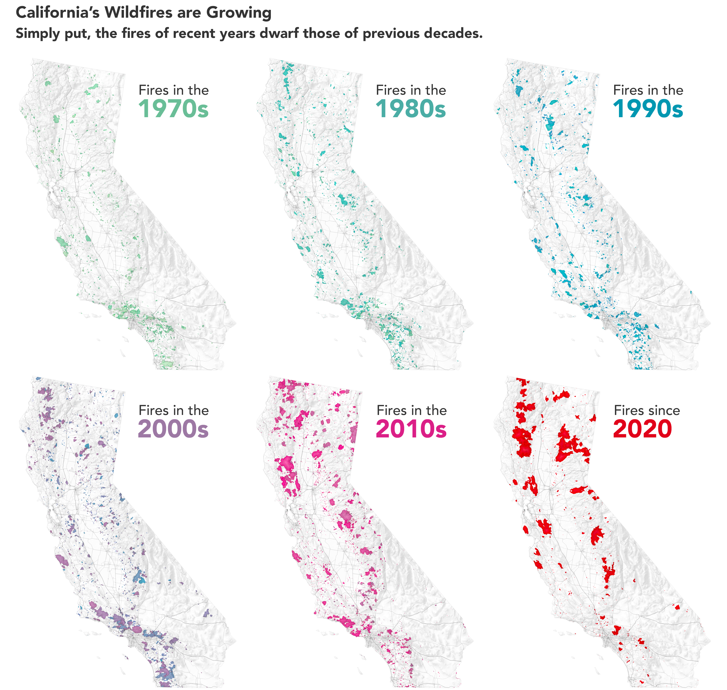
For prospective travelers, the question “How much of California is on fire?” is both urgent and complex. It’s a query that demands nuanced understanding, as the reality is rarely a simple “yes” or “no.” Wildfires are dynamic, localized events, and while their impacts can be widespread, they typically affect specific regions rather than engulfing the entire vast state. Understanding the scope, geographical implications, and essential planning strategies is paramount for anyone considering a trip to California, ensuring both safety and an enjoyable experience. This guide aims to demystify the situation, offering insights for responsible and informed travel in a state that, despite its challenges, remains an extraordinary place to visit.
Navigating the Complexities of California’s Wildfire Season
California’s wildfire season is a recurring phenomenon, primarily influenced by climatic factors such as drought, high temperatures, and strong winds. While fires have always been a part of the state’s natural cycle, human activity and climate change have contributed to an increase in their frequency, intensity, and duration. For travelers, this means a heightened awareness of the potential for fire activity, particularly during late summer and fall, traditionally the peak season. However, it’s crucial to understand that even during peak season, the vast majority of California remains unaffected by direct fire activity.
A Dynamic Landscape: Understanding the Scope
The perception of “all of California being on fire” is a common misconception perpetuated by widespread news coverage that often focuses on the most dramatic incidents. In reality, wildfires are geographically contained. California spans over 163,000 square miles, boasting a diverse topography that includes coastal regions, expansive deserts, towering mountain ranges like the Sierra Nevada, and vast agricultural lands. A fire burning in a remote national forest in Northern California, while significant, will have little direct impact on a traveler planning a beach vacation in San Diego or a city break in Los Angeles.
The challenge lies in the rapid and unpredictable nature of wildfires. A fire can emerge suddenly, escalate quickly, and shift direction with changing winds. This dynamic environment requires travelers to stay informed and flexible, understanding that conditions can evolve. However, with modern monitoring systems and extensive communication networks, real-time information is readily available, allowing for timely adjustments to travel plans.
Beyond the Flames: Air Quality and Wider Impacts
While direct fire impact is localized, smoke and poor air quality can travel significant distances, affecting areas far from the immediate blaze. Air quality is often the most widespread concern for travelers, as smoke plumes can drift hundreds of miles, causing hazy skies, reduced visibility, and potential health issues for sensitive individuals. AirNow.gov and local air quality management districts provide up-to-the-minute data on air quality, often color-coded for easy interpretation.
Beyond air quality, wildfires can lead to the closure of national parks, state parks, forests, and specific roadways for safety reasons or to allow emergency services to operate unimpeded. This can affect access to popular attractions such as Yosemite National Park, parts of the Redwood National Park area, or scenic drives along routes like Big Sur. Furthermore, the psychological impact of fires on local communities, as well as the strain on emergency resources, can subtly affect the overall travel experience in adjacent areas. It’s important for travelers to approach their trips with empathy and an understanding of these broader implications.
Geographical Insights: Key Regions and Travel Advisories
Understanding which parts of California are historically more prone to wildfires and how different regions might be affected is crucial for travel planning. While no area is entirely immune, certain landscapes and climates pose a higher risk.
Northern California: Forested Retreats and Wine Country
Northern California is home to vast forested areas, including significant portions of the Sierra Nevada mountain range, the Redwood National Park, and the iconic Napa Valley and Sonoma County wine regions. These areas, particularly those with dense vegetation and challenging terrain, are susceptible to wildfires. Travelers planning trips to destinations like Lake Tahoe for outdoor recreation or vineyard tours in the autumn should closely monitor fire activity.
While fires can occur, it’s rare for entire regions to be shut down. Often, only specific forests or parks might have closures, while nearby towns and attractions remain open. For instance, even if a fire impacts a portion of the Sierra Nevada, urban centers like San Francisco or coastal towns further west are typically unaffected by direct flames, though they might experience hazy skies or decreased air quality from distant smoke.
Central California: Sierras and Agricultural Heartlands
Central California encompasses a broad swath of the state, from the eastern slopes of the Sierra Nevada down into the fertile Central Valley. This region includes world-renowned national parks like Yosemite National Park, Sequoia National Park, and Kings Canyon National Park. These parks, with their towering trees and vast wilderness, have faced significant fire challenges. Closures, sometimes extensive, can impact visitor access.
Travelers heading to the Central Valley for agricultural tourism or to experience smaller towns are generally less impacted by direct fires, given the different landscape. However, the proximity of the Sierra Nevada means that smoke can be a significant concern, especially in communities directly west of the mountain ranges. Always check park websites and local tourism boards for the latest updates on closures and air quality before departing.

Southern California: Coastal Cities and Mountain Ranges
Southern California is famous for its vibrant cities, iconic beaches, and desert landscapes, but it also has numerous mountain ranges and chaparral ecosystems that are highly prone to wildfires, particularly with the Santa Ana winds. Cities like Los Angeles, San Diego, Santa Barbara, and Palm Springs are generally safe from direct fire impacts due to urban development and proximity to the coast or desert. However, fires in surrounding mountain ranges (e.g., San Gabriel Mountains near Los Angeles or those near Malibu) can lead to road closures, evacuations of hillside communities, and, most commonly, significant air quality issues across broad urban areas.
Beach communities and coastal attractions typically remain open, but travelers should be prepared for potential hazy conditions or, in severe cases, advice to limit outdoor activities due to smoke. Deserts like Joshua Tree National Park, while arid, can also experience brush fires, especially after unusual rainfall leads to increased vegetation growth.
Essential Travel Planning in a Fire-Prone State
Traveling to California during fire season requires a proactive and informed approach. With the right preparation, a safe and rewarding trip is entirely possible, allowing visitors to enjoy the vast majority of the state that remains untouched by active fires.
Prioritizing Safety: Before and During Your Trip
The foremost consideration for any trip during fire season is safety. Before traveling, research the specific regions you plan to visit. Check local news, fire incident websites (like Cal Fire’s public information map), and air quality reports. If active fires are burning near your intended destination, consider altering your plans.
Once in California, stay vigilant. Be aware of local emergency alerts, reverse 911 calls, and any evacuation orders. Carry a fully charged cell phone, and have a “go bag” ready with essentials if you are staying in a higher-risk area. If you see smoke or fire, do not approach it; instead, report it to emergency services and follow official instructions. Avoid activities that could spark a fire, such as campfires outside designated areas or improper disposal of cigarettes.
Adapting Itineraries: Flexibility is Key
Flexibility is a traveler’s best asset during fire season. Have alternative destinations or activities in mind, especially if your primary plans involve national parks or forested areas. If air quality in a mountain region is poor, consider shifting your focus to a coastal city, a desert escape, or an indoor attraction like a museum or gallery in San Francisco or Los Angeles. Many parts of California offer diverse experiences within a few hours’ drive, making it easy to pivot.
Booking accommodations and activities with flexible cancellation policies can also provide peace of mind. Travel insurance that covers unforeseen events like natural disasters might be a worthwhile investment, depending on the specifics of your policy.
Utilizing Official Resources for Real-Time Information
Reliable, up-to-date information is your most valuable tool. Rely on official sources for fire updates and advisories:
- Cal Fire (California Department of Forestry and Fire Protection): Their website provides incident maps, updates on active fires, and important safety information.
- National Park Service (NPS) and USDA Forest Service: Check individual park or forest websites for specific closure information and conditions.
- AirNow.gov: For real-time air quality data across the state.
- California Office of Emergency Services (CalOES): Provides statewide emergency alerts and resources.
- Local County and City Websites: Often have specific local advisories and resources.
- California Department of Transportation (Caltrans): For road closures and traffic alerts.
Follow these agencies on social media for quick updates, but always cross-reference with their official websites.
Responsible Tourism and Supporting Affected Communities
Choosing to travel to California during fire season doesn’t mean ignoring the challenges. It means traveling responsibly, safely, and with an understanding of how to support the state’s resilience.
Choosing Fire-Safe Destinations and Activities
While fires dominate headlines, vast swaths of California are typically untouched. Focus on destinations that are historically less impacted by direct fire events, such as coastal cities, urban centers, and certain desert regions. Consider exploring California’s incredible culinary scene, world-class museums, diverse cultural events, or vibrant city parks. Many of these experiences are unaffected by distant wildfires.
When visiting natural areas, adhere strictly to all fire restrictions, such as campfire bans or trail closures. Respect the natural environment, pack out what you pack in, and be mindful of any actions that could inadvertently start a fire.

Contributing to California’s Resilience
Tourism plays a vital role in California’s economy, and conscious travel can directly support communities, especially those that have been affected by wildfires. By responsibly visiting unaffected areas, travelers inject much-needed revenue into local businesses, hotels, and restaurants.
If you wish to do more, consider donating to reputable organizations involved in wildfire relief, recovery, and prevention efforts, such as the California Fire Foundation or local community foundations. Your presence and support, when exercised thoughtfully, contribute to the state’s recovery and long-term sustainability, helping California continue to thrive as a premier travel destination for years to come. The beauty of California is immense, and with mindful planning, it remains an extraordinary place to explore, even during the challenges of wildfire season.