
Independence Pass, a stunning high-alpine route traversing the Continental Divide in Colorado, presents one of the state’s most iconic and breathtaking drives. However, its accessibility is notoriously seasonal, making the question of whether it’s “open” a critical consideration for any traveler planning to experience its dramatic beauty. This article delves into the operational dynamics of Independence Pass, offering insights into its opening and closing schedules, what to expect when it is accessible, and crucial tips for a safe and unforgettable journey.
Understanding the Seasonal Dynamics of Independence Pass
The fundamental answer to “Is Independence Pass open?” is almost always “it depends on the season.” Due to its extreme elevation, reaching 12,095 feet at its summit, the pass is buried under feet of snow for more than half the year. This makes year-round travel impossible and necessitates seasonal closures for safety.

The Typical Operating Window
Historically, Independence Pass typically opens around Memorial Day weekend (late May) and closes for the winter season around early to mid-November, or with the first significant snowfall that makes conditions unsafe. These dates are not fixed; they are entirely at the mercy of Mother Nature. Factors like the depth of the winter snowpack, late spring storms, and the onset of early autumn snowfalls dictate the exact opening and closing dates each year.
The Colorado Department of Transportation (CDOT) is the sole authority responsible for managing and maintaining the pass. Their crews work diligently in the spring to clear massive snowdrifts, often 20-30 feet deep, and repair any road damage caused by avalanches or winter conditions. This meticulous effort ensures the pass is safe for vehicle traffic before it’s officially opened. Travelers should always consult official CDOT resources for the most current information regarding the pass’s status. Their website or 511 traveler information system provides real-time updates.
Why the Pass Closes
The reasons for the seasonal closure are multifaceted, primarily centered on safety and practicality. Beyond the sheer volume of snow, the pass is characterized by:
- Extreme Weather: High winds, sudden whiteouts, and rapidly plummeting temperatures are common, even outside of peak winter.
- Avalanche Danger: The steep slopes surrounding the pass are highly prone to avalanches, especially during and after snow events.
- Road Conditions: The narrow, winding road, often lacking guardrails in places, becomes incredibly perilous when icy or snow-covered.
- Maintenance: Clearing and maintaining the pass requires heavy machinery and specialized crews, which cannot operate safely during continuous winter conditions.
Understanding these dynamics is crucial for any traveler; attempting to navigate a closed pass is not only illegal but extremely dangerous.
Navigating the Pass: What to Expect When It’s Open
When Independence Pass is open, it transforms from an impenetrable winter barrier into a gateway to some of Colorado’s most awe-inspiring landscapes. This journey, however, demands respect and preparation.
The Drive Itself
The 32-mile stretch of Highway 82 that comprises Independence Pass between Aspen and Twin Lakes is not for the faint of heart or inexperienced drivers. It is a true mountain pass experience characterized by:
- Steep Grades and Hairpin Turns: Drivers will encounter significant ascents and descents with numerous tight switchbacks, particularly on the Aspen side.
- Narrow Roadway: Portions of the pass are extremely narrow, making passing difficult and requiring careful navigation when encountering oncoming traffic. There are sections where two full-sized vehicles cannot pass simultaneously, necessitating one vehicle to pull over.
- Absence of Guardrails: In many of the most dramatic sections, particularly near the summit, there are no guardrails, offering unobstructed (and dizzying) views of sheer drop-offs.
- Vehicle Restrictions: Due to the challenging terrain and narrow passages, vehicles over 35 feet in length (including trailers) are prohibited. This effectively excludes most RVs, motorhomes, and large trailer setups. It’s best to confirm your vehicle’s suitability beforehand.
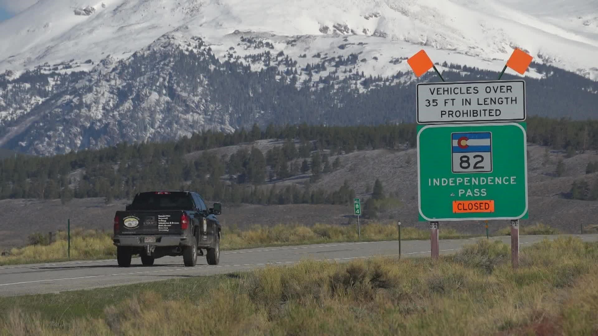
Despite these challenges, the drive is unequivocally rewarding. Panoramic vistas unfold at every turn, showcasing glacial valleys, pristine alpine lakes, and towering peaks like Mount Elbert and Mount Massive, Colorado’s two highest mountains.
Points of Interest Along the Way
The journey over Independence Pass is an attraction in itself, punctuated by several noteworthy stops:
- The Summit: At 12,095 feet, the summit offers a parking area and a short walk to the actual Continental Divide marker, complete with interpretive signs and jaw-dropping 360-degree views. This is an ideal spot for photography and soaking in the immense scale of the Rocky Mountains.
- Grottos Trail: Located on the Aspen side of the pass, this easy hiking trail leads to unique ice caves (depending on the time of year), waterfalls, and interesting rock formations carved by the Roaring Fork River.
- Lost Man Loop Trail: A more strenuous, high-alpine hiking option, this loop offers stunning views of alpine lakes and meadows, perfect for experienced hikers looking for solitude and wildflowers.
- Independence Ghost Town: Just east of Aspen, this historical mining settlement provides a glimpse into Colorado’s gold rush era. Interpreted ruins and a sense of forgotten history make it a fascinating stop.
Planning Your Trip: Essential Tips for Travelers
A successful and enjoyable journey over Independence Pass hinges on meticulous planning and awareness. Given the variable conditions and remote nature of the route, preparation is paramount.
Checking the Pass Status
Before even considering your trip, confirm the pass is open.
- CDOT Website and 511 System: The official source for real-time road conditions and opening/closing announcements.
- Local Visitor Centers: Inquire at visitor centers in Aspen, Leadville, or Twin Lakes for localized insights and recommendations.
- Webcams: Some local entities might operate webcams offering a visual check of current weather conditions.
Best Time to Visit
During its open season, the pass offers different experiences:
- Early Summer (June): Expect lingering snowdrifts at the summit, cascading waterfalls from snowmelt, and vibrant green landscapes. Wildflowers begin to emerge.
- Mid-Summer (July-August): Peak wildflower season, warmer temperatures, and typically the most reliable weather. Ideal for hiking.
- Fall (September-October): Witness spectacular autumn foliage, especially golden aspens, but be prepared for colder temperatures and the increased possibility of early snow, which can trigger an unexpected closure.
Safety and Preparedness
Driving Independence Pass is an adventure, but one that requires caution:
- Altitude Sickness: The summit is over 12,000 feet. Be aware of the symptoms of altitude sickness (headache, nausea, dizziness) and take it easy, especially if arriving from sea level. Stay hydrated.
- Rapid Weather Changes: Mountain weather is notoriously unpredictable. Sunny skies can quickly give way to thunderstorms, hail, or even snow, even in summer. Dress in layers and pack rain gear.
- Limited Services: There are no gas stations, restaurants, or reliable cell service along the pass itself. Ensure your vehicle has a full tank of gas, and bring plenty of water, snacks, and any necessary emergency supplies.
- Emergency Kit: A basic emergency kit including a first-aid kit, blankets, flashlight, and jumper cables is always a good idea when venturing into remote mountain areas.
- Respect Wildlife: You may encounter various wildlife, including deer, elk, marmots, and pikas. Maintain a safe distance and never feed wild animals.
Alternative Routes
If Independence Pass is closed, alternative routes are available, though they are significantly longer:
- Via I-70: The most common alternative involves taking I-70 to Glenwood Springs and then heading south on Highway 82 to Aspen. This adds considerable time to your journey, potentially several hours.
- Via US-24: From Twin Lakes, you can head south on US-24 through Leadville and potentially connect to other routes depending on your final destination.

The Experience: More Than Just a Drive
Beyond its practical function as a scenic bypass, Independence Pass offers an unparalleled experience that transcends mere transportation. It is a journey through diverse ecosystems, from dense evergreen forests to treeless alpine tundra. It’s a connection to Colorado’s rich history, tracing routes once used by Ute tribes and later by hardy prospectors seeking their fortunes.
The pass serves as a vital artery connecting the Roaring Fork Valley on the western slope (home to Aspen and Basalt) with the Arkansas River Valley on the eastern slope (encompassing Twin Lakes and Leadville). This connectivity allows travelers to explore vastly different facets of Colorado’s mountain culture and landscapes within a relatively short distance.
Whether it’s the thrill of driving above the tree line, the quiet awe inspired by the vastness of the Rocky Mountains from the summit, or the sheer joy of discovering an ancient bristlecone pine, Independence Pass promises an unforgettable adventure. Its seasonal opening creates a sense of anticipation, making each year’s access a special opportunity to explore one of Colorado’s most cherished natural treasures. The question of “Is it open?” isn’t just about a road; it’s about unlocking a gateway to an extraordinary travel experience.
LifeOutOfTheBox is a participant in the Amazon Services LLC Associates Program, an affiliate advertising program designed to provide a means for sites to earn advertising fees by advertising and linking to Amazon.com. Amazon, the Amazon logo, AmazonSupply, and the AmazonSupply logo are trademarks of Amazon.com, Inc. or its affiliates. As an Amazon Associate we earn affiliate commissions from qualifying purchases.