
Navigating the vast, sprawling landscape of Los Angeles can be a daunting task for both newcomers and long-term residents. With a geography defined by iconic stretches of concrete, winding canyons, and distinct cultural enclaves, understanding the boundaries of your immediate environment is essential. Whether you are searching for the best local coffee shop, identifying your municipal voting district, or simply trying to get your bearings before a day of exploration, knowing your district is the first step to mastering life in the City of Angels.
Decoding the Geographic Tapestry of Los Angeles
Los Angeles is not a monolithic city; it is a collection of diverse neighborhoods, each possessing a unique personality and regulatory identity. To determine exactly where you are, it is important to distinguish between official administrative districts, city council districts, and the neighborhood councils that define local life.
The Role of City Council Districts
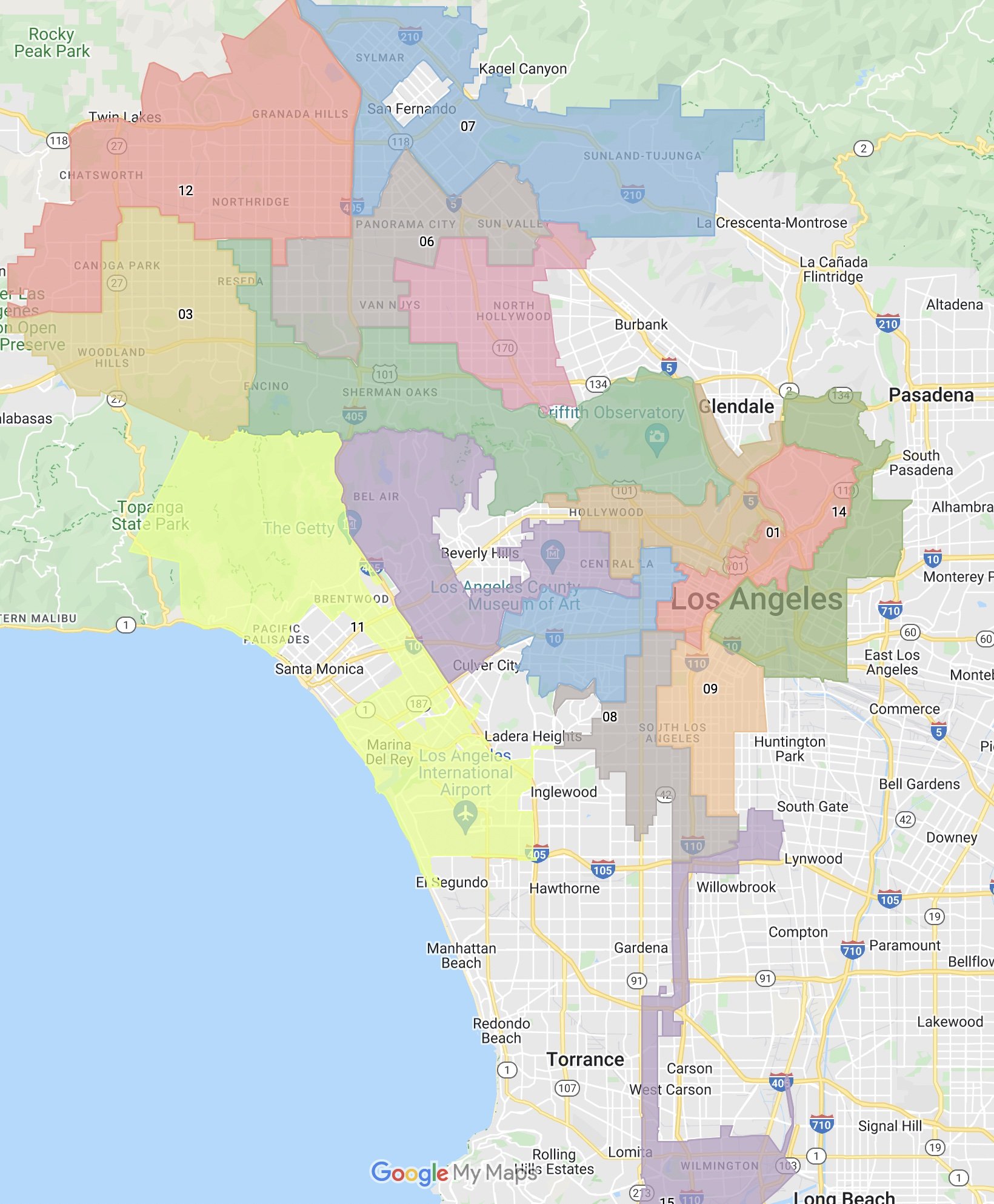
The city is divided into 15 official City Council districts. These boundaries are primarily used for political representation. When you engage with city services, report a pothole, or have concerns about local ordinances, you are interacting with the office of the council member representing your specific district. Because these lines are drawn based on population data, they change periodically through a process called redistricting. If you are ever unsure which district you fall into, the City of Los Angeles official portal provides an interactive mapping tool that allows you to input your specific street address to receive instant confirmation.
Neighborhood Councils vs. Administrative Districts
While City Council districts handle policy and legislative matters, neighborhood councils serve as a more localized conduit for community advocacy. There are over 90 neighborhood councils scattered throughout the region. These bodies are composed of elected volunteers who weigh in on land-use issues, local developments, and city budget allocations. Unlike political districts, neighborhood councils are often defined by historical identity—such as Hollywood, Venice, or Silver Lake—making them feel more like distinct communities than cold, bureaucratic zones.
Cultural Districts and Neighborhood Identities
Beyond the administrative lines lie the districts that define the tourism and cultural landscape. Los Angeles is world-renowned for its localized cultural hubs. Understanding these “districts” is vital for travelers and residents alike, as they dictate the local food, transit patterns, and aesthetic of your day-to-day experience.
Exploring the Coastal Hubs
If you find yourself near the Pacific Ocean, you are likely in one of the iconic beach districts. Santa Monica and Venice serve as the primary anchors for coastal culture. These districts are defined by a mix of high-end retail, bohemian boardwalks, and a laid-back atmosphere that contrasts sharply with the frantic pace of the interior basins. Moving slightly north, Malibu offers a more rugged, affluent experience, characterized by cliff-side estates and hidden surfing coves.

Downtown and the Central Core
For those in the heart of the region, the district known as Downtown Los Angeles (or DTLA) acts as the urban center. This area is a patchwork of sub-districts, including the Arts District, the Financial District, and the historic Little Tokyo. Each of these pockets has its own micro-climate of culture; the Arts District leans heavily into industrial-chic lofts and contemporary murals, while Little Tokyo preserves deep roots in tradition, architecture, and culinary excellence.
How to Orient Yourself in the Sprawl
If you are physically standing in an unknown part of California, orienting yourself requires a combination of digital tools and observational skills. The sheer scale of the Los Angeles region can make it easy to drift across multiple municipal boundaries in a single afternoon.
Utilizing Digital Mapping Tools
Modern technology has made the question “What district am I in?” much easier to answer. Most mapping applications provide more than just directions; they now label neighborhood boundaries, administrative zones, and points of interest with high precision. When checking your location, zoom out to the neighborhood level. Often, the app will label the surrounding area, helping you identify if you are in West Hollywood, Beverly Hills, or Culver City. Note that some of these areas are independent cities, meaning they have their own police departments, city halls, and distinct governing laws, separate from the City of Los Angeles.
Visual Clues and Local Signage
Sometimes the best way to determine your district is to look at your surroundings. In Los Angeles, local pride is strong, and districts are frequently demarcated by physical signage. Keep an eye out for neighborhood banners on street lights or monuments that define the entrance to a specific district. For example, the iconic Hollywood Sign serves as a distant landmark, but smaller, ground-level signs indicating you are entering Koreatown or Echo Park are usually reliable markers of your current location.
Navigating the Boundaries of Lifestyle and Tourism
The purpose of knowing your district often shifts depending on your intent. If you are here for tourism, you are likely looking for the boundaries of entertainment districts. If you are living here, you are likely looking for the boundaries of your local governance.
The Tourist Perspective
For visitors, districts like Sunset Strip or the Walk of Fame are the goal. Identifying these districts helps you cluster your activities. Rather than trying to see the Griffith Observatory and the Santa Monica Pier in a single morning, knowing the districts they reside in—Griffith Park and the coast, respectively—allows for realistic itinerary planning. The traffic in Los Angeles is a function of the distance between these districts; respect the boundaries to avoid spending your entire vacation in a vehicle.

The Resident Perspective
For those residing in the area, the district lines are a matter of logistical planning. Trash collection days, parking permit zones, and public school boundaries are all tied to these lines. Understanding your specific district’s regulations can save you from unnecessary parking fines or confusion regarding city services. Furthermore, becoming active in your local district creates a sense of belonging in a city that can otherwise feel vast and impersonal. Whether you are participating in a local election or attending a community garden cleanup in Highland Park, knowing your district is the foundational step toward becoming a true member of the Los Angeles community.
By staying curious and using the resources provided by the City of Los Angeles, you can peel back the layers of this complex metropolis. Whether you find yourself wandering through the luxury boutiques of Rodeo Drive or enjoying the street food in Boyle Heights, you are always within a specific district that contributes to the vibrant, multifaceted identity of the region. Embrace the exploration, respect the boundaries, and enjoy the distinct flavors that each unique corner of this city has to offer.
LifeOutOfTheBox is a participant in the Amazon Services LLC Associates Program, an affiliate advertising program designed to provide a means for sites to earn advertising fees by advertising and linking to Amazon.com. Amazon, the Amazon logo, AmazonSupply, and the AmazonSupply logo are trademarks of Amazon.com, Inc. or its affiliates. As an Amazon Associate we earn affiliate commissions from qualifying purchases.