
Colorado, a state renowned for its majestic Rocky Mountains, vibrant cities, and diverse landscapes, is a premier destination for travelers worldwide. Whether planning a scenic road trip, a ski vacation, a hiking expedition, or a cultural city break, understanding the geographical nuances, including its zip code system, is invaluable for any visitor. While there isn’t a single “Colorado zip code” that encompasses the entire state, Colorado is subdivided into numerous unique postal codes, each serving a specific geographical area. These five-digit identifiers are far more than just mailing addresses; they are crucial tools for navigation, service identification, and understanding the intricate tapestry of communities that make up the Centennial State. For the discerning traveler, grasping the logic behind Colorado’s zip codes can significantly enhance their journey, streamlining logistics and deepening their connection to the places they visit.
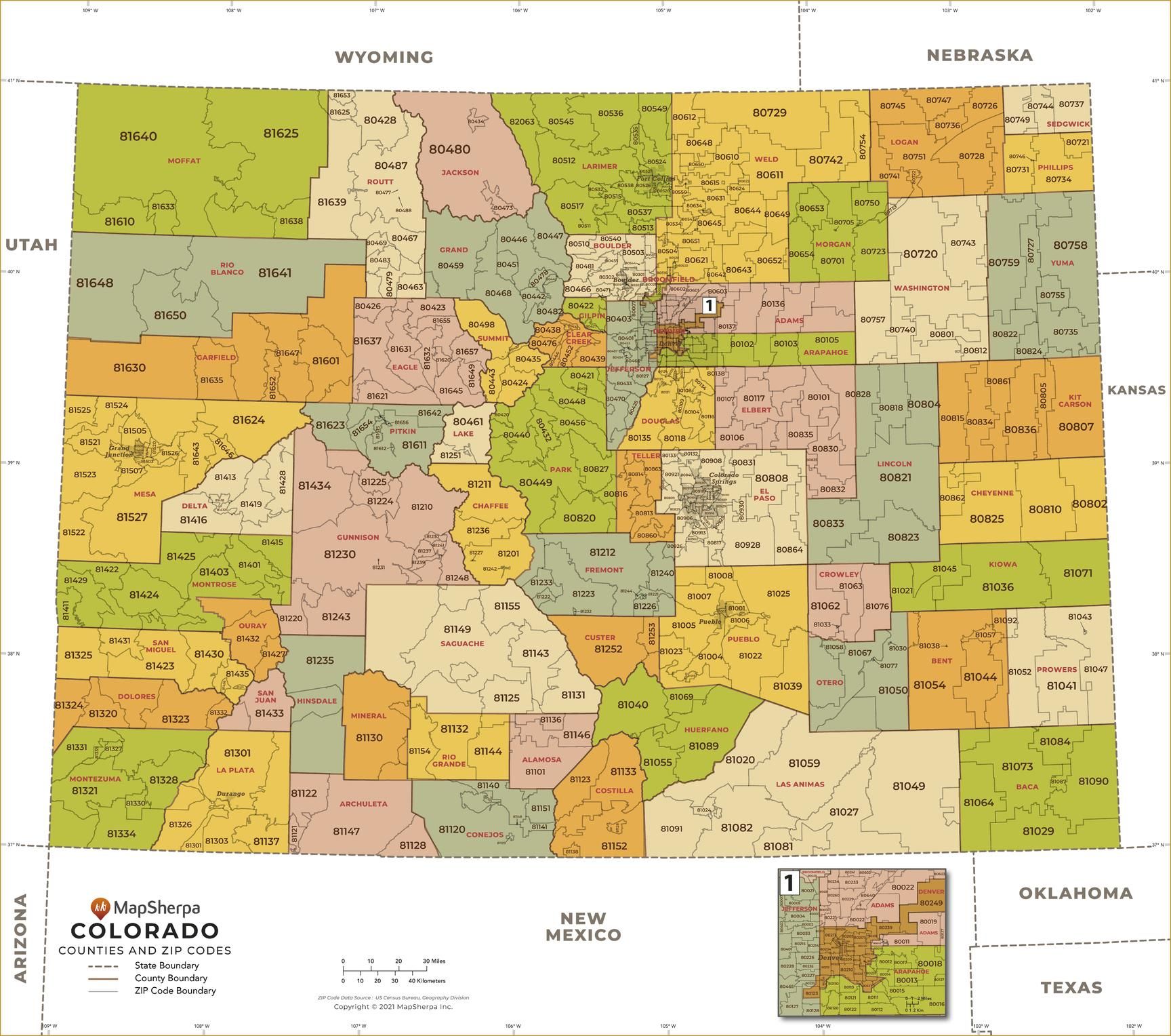
Understanding Colorado’s Zip Code Landscape
The United States Postal Service (USPS) introduced the Zone Improvement Plan (ZIP) codes in 1963 to improve mail sorting and delivery. For a vast and geographically varied state like Colorado, this system plays a critical role in organizing its vast expanse. The first digit of a Colorado zip code typically indicates a broad geographical area within the United States. Most zip codes in Colorado begin with the number “8,” specifically falling within the 800-816 range. This ‘8’ prefix signals that the location is in the Mountain West region of the U.S., shared with neighboring states like Wyoming, Utah, and Idaho.
The subsequent two digits, the second and third, narrow down the geographical area to a specific region or major city within Colorado. For instance, the zip codes around Denver, the state capital and largest city, primarily start with ‘802’ or ‘800’ (for parts of the Denver Metro Area). As you move away from the central urban hubs towards more rural or mountainous regions, these middle digits change, reflecting the distinct postal zones. The final two digits, the fourth and fifth, pinpoint the precise post office or delivery area within that region. This hierarchical structure allows for incredibly precise targeting, which is essential not only for mail delivery but also for a multitude of other applications relevant to travelers. From booking accommodations to ordering supplies, knowing the correct zip code ensures smooth transactions and accurate service provision.
The Role of Geography in Zip Code Assignment
Colorado’s diverse topography—ranging from the high plains in the east to the towering peaks of the Rocky Mountains and the plateaus of the Western Slope—significantly influences the distribution and density of its zip codes. Densely populated areas like Denver and Colorado Springs have numerous zip codes within a relatively small geographic footprint, each covering specific neighborhoods or commercial districts. In contrast, sparsely populated mountain counties or rural plains areas might have a single zip code covering a vast territory, sometimes encompassing multiple small towns or expansive wilderness. This geographical consideration is vital for travelers. A zip code can often be a quick indicator of the type of environment one can expect: an urban setting, a suburban sprawl, a remote mountain community, or an agricultural plain. This insight aids in selecting appropriate lodging, understanding travel times, and even anticipating the availability of services.
Navigating Colorado’s Regions Through Zip Codes
For travelers, zip codes can serve as an invaluable geographical shorthand, helping to delineate the various regions of Colorado and understand their unique characteristics.
The Front Range Urban Corridor
The Front Range Urban Corridor is home to the majority of Colorado’s population and its largest cities. This area stretches from Pueblo in the south to Fort Collins in the north.
- Denver and Surrounding Areas: The core of Denver typically falls within the 802XX range, with variations for specific neighborhoods. For example, downtown Denver might use 80202, while residential areas spread across 80203, 80204, and higher numbers depending on their location. Suburbs like Aurora and Lakewood have their own sets, often starting with 800XX or 801XX.
- Colorado Springs: South of Denver, Colorado Springs utilizes zip codes predominantly in the 809XX series, such as 80903 for its downtown area and others like 80918 for northern parts of the city.
- Boulder: Known for its vibrant culture and proximity to the Flatirons, Boulder typically uses 803XX zip codes, with 80302 being common for the city center.
- Fort Collins: Located in northern Colorado, Fort Collins uses zip codes mainly in the 805XX range, such as 80521 for the main university area.
These specific ranges help travelers quickly identify if a particular address is within a major urban center, which might imply access to a wide array of services, public transport, and various attractions.
The Mountain Regions
Travelers heading into Colorado’s famous ski resorts and wilderness areas will encounter distinct zip codes that reflect the more remote and specialized nature of these destinations.
- Aspen and the Roaring Fork Valley: Aspen’s primary zip code is 81611, while nearby Snowmass Village uses 81615. These fall within the 816XX range, common for much of the Western Slope mountain communities.
- Vail and the Eagle River Valley: Vail uses 81657, and its neighbors like Edwards and Avon use 81632 and 81620 respectively, again fitting into the 816XX series.
These zip codes often signify areas with unique challenges and offerings, from seasonal road closures to specialized mountain activities and unique local economies.
The Eastern Plains and Western Slope
Beyond the mountains, Colorado extends into the Eastern Plains and the Western Slope, each with its own postal patterns.
- Eastern Plains: Towns like Limon (80828) or Burlington (80807) use zip codes primarily in the 808XX range, indicating the more rural, agricultural character of this region.
- Western Slope: Cities like Grand Junction, the largest city on the Western Slope, utilize zip codes such as 81501, 81503, and 81504, typically within the 815XX range, reflecting its distinct geographical and economic identity focused on agriculture, energy, and outdoor recreation.
Practical Applications for Colorado Travelers

For visitors to Colorado, zip codes offer several practical advantages that can significantly smooth their travel experience.
Enhanced Navigation and Location Services
Modern GPS systems and mapping applications heavily rely on zip codes for accurate location identification and route planning. When searching for a specific restaurant, hotel, or attraction, providing the zip code alongside the address can sometimes yield more precise results, especially in areas with similar street names or complex numbering systems. Furthermore, understanding the general zip code ranges for different parts of Colorado allows travelers to quickly contextualize an address and estimate distances, travel times, and the type of environment they will encounter. For instance, knowing an address is in an 802XX zip code immediately flags it as being within or very close to Denver.
Streamlining Deliveries and Online Shopping
Many travelers require package deliveries, whether it’s forgotten items, online purchases, or specialized gear. Having the correct zip code for their temporary accommodation (hotel, vacation rental, or campsite with a postal service) is paramount for ensuring timely and accurate delivery. E-commerce websites and shipping carriers use zip codes to calculate shipping costs, estimate delivery times, and verify service availability. Misinformation here can lead to significant delays or lost packages, inconveniencing the traveler.
Identifying Local Services and Resources
Zip codes are often used by businesses and government agencies to define service areas. When searching for local services such as a car rental agency, a specific medical facility, a utility provider (for long-term stays), or even a local tour operator, filtering by zip code can quickly identify options available in a specific vicinity. This is particularly useful in sprawling urban areas or when in remote locations where service options might be limited. For example, an emergency service or local repair shop will primarily serve specific zip code zones. Knowing the area’s zip code simplifies accessing these critical resources.
Understanding Accommodation Options and Pricing
When browsing for hotels, vacation rentals, or campgrounds, platforms often allow filtering by zip code. This enables travelers to narrow down options to specific neighborhoods or regions that align with their itinerary or budget. While not the sole determinant, zip codes can sometimes correlate with general price ranges for accommodations, reflecting the desirability, amenities, or remoteness of an area. For instance, an 81611 zip code ( Aspen) will generally indicate higher accommodation costs compared to an 808XX zip code in the Eastern Plains.
Beyond the Standard: Colorado Zip Codes and Local Life
While primarily a postal identifier, the zip code often provides a subtle insight into the local character and administrative structure of a Colorado community.
Demographic and Economic Indicators
Researchers, urban planners, and businesses often use zip code data to analyze demographics, economic trends, and community profiles. While travelers won’t delve into this depth, understanding that a zip code can signify a specific demographic makeup or economic focus can subtly inform their travel choices. For example, a zip code predominantly associated with a college town like 80302 (Boulder) might suggest a younger demographic, vibrant nightlife, and a focus on outdoor activities. Conversely, a zip code associated with a more industrial area might offer different services and attractions.

Emergency Services and Local Jurisdiction
In emergency situations, providing the exact street address and zip code helps emergency responders quickly locate the incident and dispatch the appropriate local jurisdiction (police, fire, or ambulance). This is crucial for safety, especially when exploring less familiar areas of Colorado’s vast wilderness or navigating its complex urban environments. Even when reporting non-emergency issues, such as a traffic complaint or a public maintenance request, the zip code is often a required piece of information to route the request to the correct local authority.
In conclusion, while “What Is Colorado Zip Code?” might seem like a straightforward question, the answer reveals a complex, yet incredibly useful, system. For any traveler exploring the grandeur of Colorado, appreciating the structure and utility of its zip codes transforms a mundane postal detail into a powerful tool for informed navigation, efficient logistics, and a deeper understanding of the diverse places and communities that await discovery. From the bustling streets of Denver to the serene slopes of Vail, the humble five-digit code is an unspoken guide, silently directing the flow of information, goods, and people across this magnificent state.
LifeOutOfTheBox is a participant in the Amazon Services LLC Associates Program, an affiliate advertising program designed to provide a means for sites to earn advertising fees by advertising and linking to Amazon.com. Amazon, the Amazon logo, AmazonSupply, and the AmazonSupply logo are trademarks of Amazon.com, Inc. or its affiliates. As an Amazon Associate we earn affiliate commissions from qualifying purchases.