
In the vast and varied landscape of California, certain landmarks stand out not just for their physical presence but for their profound historical, cultural, and economic significance. Among these, The Grapevine holds a unique and often challenging position. More than just a stretch of asphalt, The Grapevine is an iconic, formidable mountain pass that serves as a critical gateway, linking the agricultural heartland of the Central Valley with the bustling metropolitan expanse of Southern California. It’s a place of dramatic elevation changes, historical narratives, and a constant reminder of both human ingenuity and nature’s enduring power. For many, navigating The Grapevine is an essential California experience, a journey that offers breathtaking views, formidable weather challenges, and a tangible connection to the state’s pioneering past. Understanding The Grapevine means delving into its geography, tracing its evolution as a vital transportation corridor, appreciating the engineering feats it represents, and acknowledging its continuous role in the fabric of California life.

A Geographical Gateway: Locating The Grapevine
The Grapevine’s identity is inextricably linked to its distinctive geographical setting. It is not merely a section of road but a prominent feature of California’s intricate mountain ranges, forming a natural barrier and a crucial conduit simultaneously.
The Physical Landscape
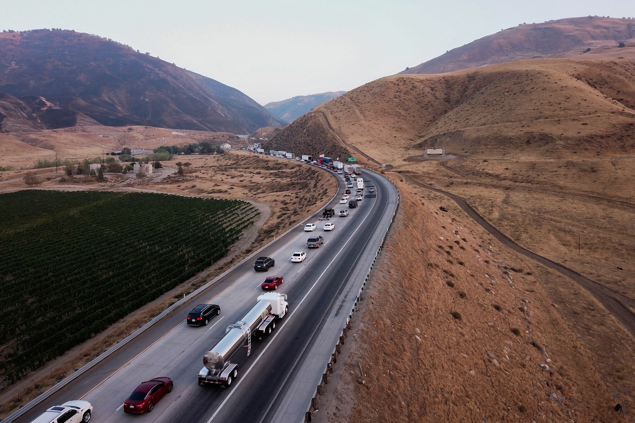
At its core, The Grapevine refers to the approximately 18-mile-long section of Interstate 5 (I-5) that traverses the rugged Tehachapi Mountains. This segment of the highway is characterized by significant elevation changes, climbing from roughly 1,200 feet above sea level at the southern end of the San Joaquin Valley to its highest point, Tejon Pass, at an elevation of 4,144 feet. The road then descends sharply into the northern reaches of Southern California. The name itself is believed to derive from Grapevine Canyon, a narrow gorge through which the original path wound, historically abundant with wild grapes. The topography here is dramatic, featuring steep grades that test the limits of vehicles and drivers alike, offering expansive vistas of the surrounding semi-arid landscape and dense oak woodlands. This unique confluence of mountains, valleys, and passes makes The Grapevine a natural wonder and an engineering challenge rolled into one.
Connecting Northern and Southern California
The strategic importance of The Grapevine cannot be overstated. It acts as the primary overland artery connecting the populous urban centers of Southern California, such as Los Angeles and its sprawling environs, with the vast agricultural region of the Central Valley and, by extension, northern parts of the state. For commerce, tourism, and daily commutes, Interstate 5 through The Grapevine is an indispensable link. Without this passage, travel and transport between these two powerhouse regions of California would be significantly prolonged and complicated, forcing traffic onto more circuitous routes over other mountain passes like those through the Antelope Valley or the Mojave Desert. Its location effectively funnels a massive volume of traffic, solidifying its status as one of the most critical and heavily traveled mountain passes in the entire United States.
A Legacy Forged in Asphalt: The Grapevine’s Rich History
The path through The Grapevine is not merely a modern construction; it carries echoes of centuries of travel and human endeavor, evolving from rudimentary trails to the superhighway it is today. Its history is a testament to the persistent need for connection across geographical divides.
From Ancient Trails to Modern Freeways
Before the advent of motorized vehicles, the route through Grapevine Canyon and Tejon Pass served as a vital pathway for indigenous peoples, connecting different tribal territories across the mountain ranges. Later, during the Spanish colonial era, this corridor became part of El Camino Viejo, an inland route used by explorers, missionaries, and settlers traveling between Los Angeles and the missions of the Central Valley. As California transitioned into American statehood, the route gained further prominence. Wagon roads were established, albeit challenging and often treacherous, catering to gold seekers, ranchers, and early pioneers. The mid-19th century saw the establishment of Fort Tejon State Historic Park near the base of The Grapevine, originally a US Army outpost designed to protect settlers and control Native American populations, further cementing the area’s significance as a strategic point. This deep historical lineage underscores The Grapevine’s enduring role as a crossroads.
The Birth of a Major Artery

The real transformation of The Grapevine began in the early 20th century with the dawn of the automobile. Recognizing the necessity of a reliable paved road, engineers embarked on ambitious projects. The original Ridge Route, completed in 1915, was an engineering marvel for its time. This winding, narrow two-lane road traversed the mountain ridges, largely avoiding the steepest grades and providing a relatively safer (though still demanding) passage than its predecessors. It was a critical component of what would become U.S. Route 99 (US 99), often referred to as “The Main Street of California,” which carried the bulk of north-south traffic for decades. As traffic volumes surged post-World War II, the need for an even more efficient and higher-capacity route became apparent. This led to the construction of Interstate 5, which largely bypassed the original Ridge Route with a more direct alignment through Grapevine Canyon, featuring multiple lanes and gentler (though still substantial) grades. The construction of modern Interstate 5 through The Grapevine was a monumental undertaking, employing advanced road-building techniques to tame the challenging terrain, cementing its status as an engineering marvel and a cornerstone of California’s transportation infrastructure.
Navigating Nature’s Challenges: The Grapevine’s Impact and Features
Despite its sophisticated engineering, The Grapevine remains a dynamic interaction between human infrastructure and the forces of nature. Its distinctive features continue to shape travel and commerce across California.
Weather Extremes and Engineering Marvels
The Grapevine is notorious for its challenging weather conditions, which can drastically impact travel. Due to its significant elevation and position between climatic zones, it is prone to extreme weather events. In winter, heavy snowfall can lead to hazardous driving conditions and frequent closures, sometimes stranding thousands of travelers. Dense fog, especially during colder months, can severely reduce visibility, necessitating extreme caution. High winds are also a common occurrence, particularly near Tejon Pass, posing risks to high-profile vehicles. Conversely, summers bring intense heat, which can strain vehicles and infrastructure. The engineering of Interstate 5 through The Grapevine is designed to mitigate these challenges, with multiple lanes, emergency runaway ramps, and extensive drainage systems. Road crews work tirelessly to keep the pass open and safe, employing snowplows, de-icing equipment, and rapid response units during adverse conditions. These ongoing efforts underscore the critical nature of maintaining this artery.
A Vital Economic and Cultural Lifeline
Beyond its physical attributes, The Grapevine functions as a vital economic and cultural lifeline for California. As a primary freight corridor, it facilitates the movement of countless goods between the massive port complexes of Southern California and the agricultural bounty of the Central Valley, as well as beyond to other states. This constant flow of commerce is essential for the state’s economy, impacting everything from fresh produce distribution to manufactured goods. Culturally, The Grapevine is deeply ingrained in the psyche of Californians and frequent travelers. It represents a threshold, a transition point between distinct regions of the state. For those traveling north, reaching the top of The Grapevine signifies the descent into the vast plains of the Central Valley. For those heading south, conquering the ascent heralds the approach to Los Angeles and the diverse offerings of Southern California. It’s a place of collective experience, where tales of challenging drives and spectacular views are commonly shared.
Experiencing The Grapevine: A Traveler’s Perspective
For drivers and passengers, traversing The Grapevine is an unavoidable and often memorable part of traveling through California. It demands respect and preparation, but also rewards with a distinctive journey.
The Drive Itself
Driving The Grapevine is an experience of contrasts. The ascent from either direction involves sustained climbs and descents over multiple miles. From the south, after passing Castaic, the road begins its steady climb, offering increasingly panoramic views as elevation is gained. Near the summit at Tejon Pass, the landscape opens up, revealing expansive vistas of the Tehachapi Mountains and, on clear days, even glimpses of the distant Mojave Desert. Traveling southbound, the descent from Tejon Pass into Grapevine Canyon is equally dramatic, characterized by long, steep stretches that require careful braking and attention to speed. Along the route, significant landmarks like the sprawling Tejon Ranch, one of California’s largest private landholdings, add to the sense of place. The sheer scale of the landscape, coupled with the constant flow of traffic, creates a dynamic and often awe-inspiring drive. For many, the sight of the road snaking its way up or down the mountainside is a quintessential California image.
Preparations and Pit Stops
Given the challenging nature of The Grapevine, proper preparation is crucial. Before embarking on the journey, travelers are advised to check local weather forecasts, especially during winter months, for potential snow, ice, or high wind warnings. Ensuring the vehicle is in good condition, with adequate fuel, tire pressure, and brake functionality, is paramount. Drivers of large vehicles or those towing trailers need to be particularly cautious on the steep grades. At the base and summit of The Grapevine, travelers will find numerous services designed to cater to their needs. Towns like Lebec and Frazier Park offer gas stations, restaurants, and lodging options, serving as convenient pit stops before or after tackling the pass. These service areas are not just commercial hubs but also informal community centers, where travelers often pause to gather information, refuel, and prepare for the next leg of their journey. The presence of these amenities underscores the functional importance of The Grapevine as a major thoroughfare requiring dedicated support infrastructure.
In conclusion, The Grapevine is far more than simply a section of Interstate 5 in California. It is a landmark of immense geographical significance, a testament to centuries of human movement and engineering prowess, and a critical nexus for the state’s economy and culture. From its ancient origins as indigenous trails to its modern incarnation as a bustling freeway, The Grapevine has continually served as a vital connector, shaping the landscape and the lives of those who traverse it. Its formidable challenges, from steep grades to extreme weather, are met with continuous maintenance and innovation, ensuring its enduring role as an iconic and indispensable part of the California experience. For any traveler, understanding “What Is The Grapevine In California?” reveals a rich tapestry of history, geography, and human endeavor that defines one of the state’s most storied passages.
LifeOutOfTheBox is a participant in the Amazon Services LLC Associates Program, an affiliate advertising program designed to provide a means for sites to earn advertising fees by advertising and linking to Amazon.com. Amazon, the Amazon logo, AmazonSupply, and the AmazonSupply logo are trademarks of Amazon.com, Inc. or its affiliates. As an Amazon Associate we earn affiliate commissions from qualifying purchases.