
California is a land of paradoxes: famed for its golden sunshine, vibrant culture, and innovative spirit, it also lies squarely atop one of the most seismically active regions on Earth. The state’s captivating natural beauty, from its towering mountain ranges to its sprawling valleys, is a direct consequence of immense geological forces that relentlessly reshape the landscape. Understanding California’s history, its resilience, and its very identity requires acknowledging these powerful natural phenomena, particularly earthquakes. While many associate California with the devastating 1906 San Francisco Earthquake, the question of the strongest earthquake, measured by magnitude, leads us to an earlier, less populated era, revealing a seismic event of colossal proportions that left an indelible mark on the state’s geological record.
California’s Seismic Legacy: A Landscape Defined by Movement
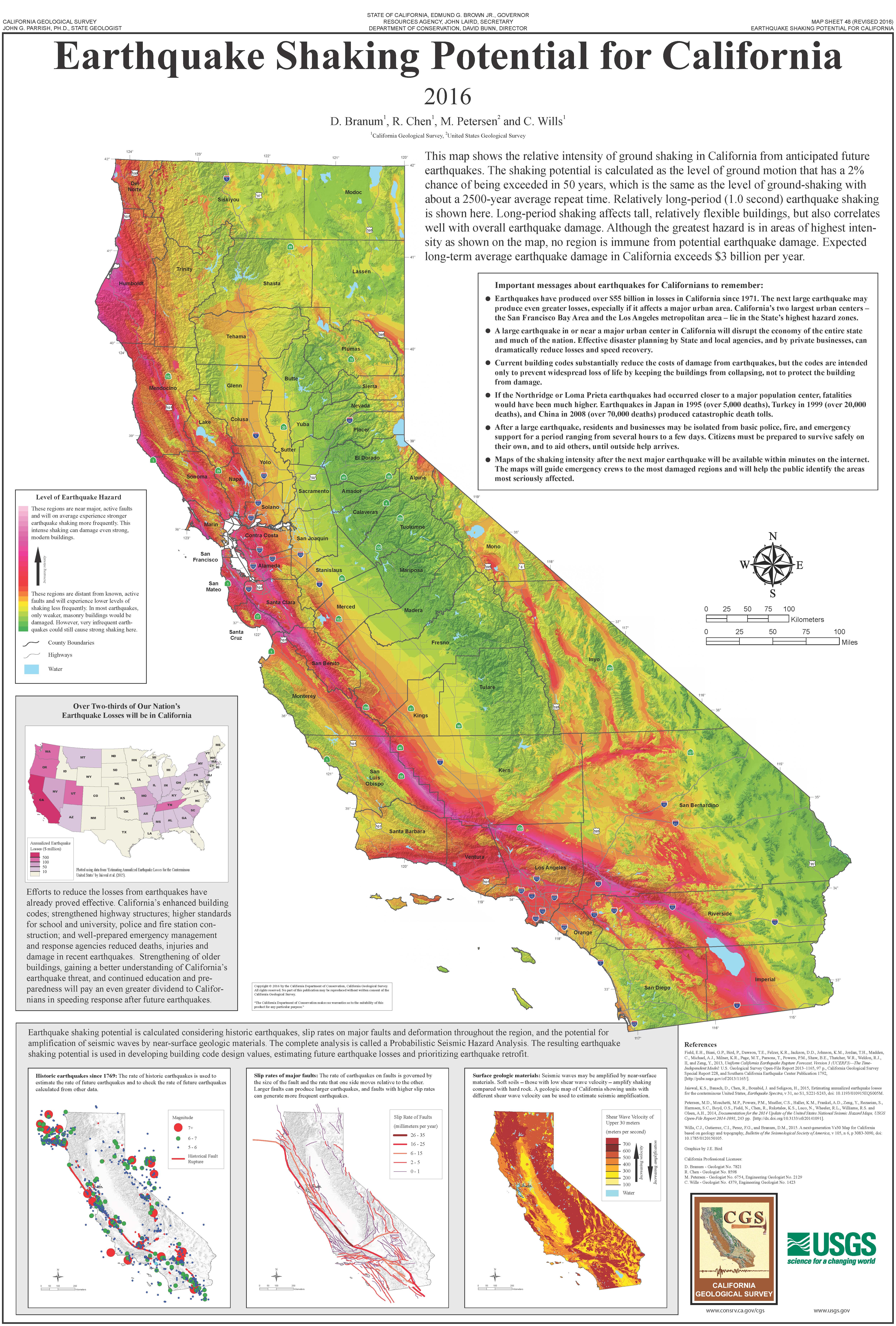
California’s dynamic geology is primarily a result of its position along the boundary between the Pacific Plate and the North American Plate. This interaction, part of the larger Pacific Ring of Fire, generates the constant tectonic stresses that define the region. The most famous manifestation of this boundary is the San Andreas Fault, a right-lateral strike-slip fault system that slices through the state for approximately 800 miles. This iconic fault system, along with numerous other interconnected fault lines like the Hayward Fault, Garlock Fault, and Elsinore Fault, makes California a living laboratory for seismic activity. Earthquakes are not merely isolated incidents but intrinsic features that have sculpted its mountains, formed its valleys, and fundamentally influenced its historical development and the character of its communities. These geological “landmarks” are invisible yet omnipresent, constantly reminding residents of the powerful forces beneath their feet and shaping their understanding of their place in the natural world.
The Colossus of 1857: The Fort Tejon Earthquake
When discussing the strongest earthquake in California based on magnitude, scientific consensus points to the Fort Tejon Earthquake of January 9, 1857. This monumental event, often overlooked in popular history due to its occurrence in a sparsely populated region, stands as the benchmark for extreme seismic activity in recorded California history.
Magnitude and Reach
The Fort Tejon Earthquake is estimated to have had a moment magnitude of approximately 7.9. This immense tremor was generated by a rupture along the San Andreas Fault that stretched for an astonishing distance, estimated to be between 185 to 225 miles. The rupture began near Parkfield in Central California and propagated southward, extending as far as the Cajon Pass in Southern California. The ground slipped laterally by as much as 30 feet in some areas, a staggering displacement that fundamentally altered the landscape. Shaking was felt across the entire state, from Sacramento in the north to San Diego in the south, and even extended into Nevada and Arizona. The sheer scale of the fault rupture and the vast area over which significant shaking occurred unequivocally designate it as the most powerful earthquake in California’s recorded history by energy release.
Impact and Aftermath
Despite its colossal magnitude, the human toll of the Fort Tejon Earthquake was remarkably low, primarily because California was still largely undeveloped. The region directly over the fault rupture was sparsely populated, consisting mainly of scattered ranches and military outposts. The most significant damage occurred at Fort Tejon, a military garrison in the Tehachapi Mountains (hence the earthquake’s name), where adobe buildings were heavily damaged and rendered uninhabitable. In Los Angeles, which had a population of only a few thousand at the time, damage was reported, including cracked walls and collapsed parapets, but no widespread destruction or fires. Similarly, reports from San Bernardino and other settlements described significant shaking and some structural damage, but remarkably, only one fatality was directly attributed to the earthquake, occurring when a porch collapsed on an individual in Los Angeles County. Geologically, however, the impact was profound. Extensive surface ruptures were observed along the San Andreas Fault, river courses were altered, and widespread liquefaction occurred in areas with saturated soil. The Fort Tejon Earthquake serves as a stark reminder of the immense destructive potential inherent in the San Andreas Fault, a potential that has only grown as California’s population and infrastructure have expanded.
The Devastation of 1906: The San Francisco Earthquake and Fire
While the 1857 event holds the record for magnitude, the 1906 San Francisco Earthquake is arguably the most famous and certainly the most impactful in terms of human suffering and infrastructural damage. Its devastating consequences are etched into California’s historical narrative, fundamentally altering the trajectory of one of its most iconic cities.

A City in Ruins
Occurring on April 18, 1906, the San Francisco Earthquake is estimated to have had a magnitude of 7.9, similar to the 1857 event. The rupture occurred along the northern segment of the San Andreas Fault, stretching for approximately 296 miles, from San Juan Bautista to Cape Mendocino. While the shaking itself was intense and destructive, particularly in areas built on unstable landfill, the true catastrophe for San Francisco was the ensuing firestorm. Broken gas lines and water mains, coupled with overwhelmed fire departments, allowed uncontrolled blazes to rage for several days, incinerating over 25,000 buildings and consuming over 4.7 square miles of the city. The iconic cityscape of San Francisco, a beacon of the West, was transformed into a smoldering ruin. The destruction was so widespread that it prompted national and international relief efforts, highlighting the interconnectedness of communities even in the early 20th century.
Historical and Societal Repercussions
The human cost of the 1906 disaster was staggering. Current estimates place the death toll at over 3,000, making it one of the deadliest natural disasters in U.S. history. Over 200,000 people were left homeless in San Francisco and the surrounding Bay Area, creating an unprecedented humanitarian crisis. Yet, from the ashes, a new San Francisco rose, often referred to as the “Phoenix City.” The earthquake and fire acted as a powerful catalyst for change. It spurred advancements in seismological research, leading to a deeper understanding of fault lines and earthquake mechanics. It forced cities to rethink building practices, ultimately leading to the development and implementation of more stringent building codes designed to withstand seismic forces. The event also solidified the mythos of California’s resilience and pioneering spirit, shaping its identity as a place where nature’s power is ever-present, but human ingenuity and determination prevail.
Other Significant Seismic Events Shaping California’s History
While 1857 and 1906 stand out, California’s history is punctuated by numerous other significant earthquakes that have collectively forged its character and influenced its development. Each event, a distinct “natural landmark,” contributes to the state’s unique historical tapestry.
The 1872 Owens Valley Earthquake
The Owens Valley Earthquake, striking on March 26, 1872, in Eastern California, was another extremely powerful event, estimated at a magnitude of 7.8. It resulted in profound surface rupture, with vertical displacements of up to 20 feet and horizontal shifts of 16 feet. While the Owens Valley was sparsely inhabited at the time, the earthquake caused immense destruction in the nascent towns of Lone Pine and Independence, leading to an estimated 27 deaths. Its impact was far-reaching, even ringing church bells in San Francisco. This earthquake highlights that not all major seismic activity is confined to the San Andreas Fault system, and other complex fault systems throughout the state also pose significant threats.
Mid-20th Century and Beyond
Post-1906, subsequent earthquakes, though smaller in magnitude than the colossal events of the 19th century, continued to shape California’s approach to seismic safety and urban planning. The 1933 Long Beach Earthquake (magnitude 6.4) prompted the passage of the Field Act, mandating earthquake-resistant design for all public school buildings. The 1971 San Fernando Earthquake (magnitude 6.6) revealed critical vulnerabilities in hospital structures and freeway overpasses, leading to revised engineering standards. The 1989 Loma Prieta Earthquake (magnitude 6.9), famously striking during the World Series, caused significant damage to the Bay Area infrastructure, particularly the Oakland Bay Bridge and the Cypress Street Viaduct, driving major investments in seismic retrofitting. Most recently, the 1994 Northridge Earthquake (magnitude 6.7) impacted Los Angeles’ urban core, causing billions in damage and further refining building codes for residential and commercial structures. Each of these events, in its own way, has contributed to the collective memory and evolving resilience of the Golden State.

Living with the Earth: California’s Resilience and Future
The history of earthquakes in California is not merely a chronicle of destruction, but a narrative of adaptation, scientific advancement, and enduring resilience. The knowledge gained from events like the 1857 Fort Tejon Earthquake and the 1906 San Francisco Earthquake has been instrumental in shaping modern California. Today, the state is at the forefront of seismological research, with sophisticated monitoring networks like the California Integrated Seismic Network providing crucial data. Advanced engineering practices and stringent building codes are continuously updated to mitigate future risks. The ongoing public discourse about the “Big One” is not one of fear but of preparedness, reflecting a deep-seated understanding that living in California means coexisting with powerful natural forces. These historical seismic events are, in essence, natural landmarks – defining moments and features that are as integral to California’s story as its famous beaches, towering redwoods, and bustling cities. They remind us that the earth beneath our feet is a living, moving entity, and understanding its rhythm is key to appreciating the unique and dynamic character of this remarkable state.
LifeOutOfTheBox is a participant in the Amazon Services LLC Associates Program, an affiliate advertising program designed to provide a means for sites to earn advertising fees by advertising and linking to Amazon.com. Amazon, the Amazon logo, AmazonSupply, and the AmazonSupply logo are trademarks of Amazon.com, Inc. or its affiliates. As an Amazon Associate we earn affiliate commissions from qualifying purchases.