
The Mississippi River is not merely a body of water; it is a monumental natural landmark, a defining feature of the North American continent, and a cornerstone of United States geography and history. Its immense length, diverse ecosystems, and pivotal role in shaping the nation’s development make it an object of profound study and admiration. Spanning over 2,300 miles from its humble beginnings in Minnesota to its grand delta in Louisiana at the Gulf of Mexico, the river traverses a remarkable ten states, each bearing its unique imprint of this majestic waterway. Understanding which states the Mississippi River flows through is essential to appreciating its scale, its impact, and its enduring legacy as a landmark of unparalleled significance.
The Mighty Mississippi: A Geographic Overview
The Mississippi River holds the distinction of being the second-longest river in North America and one of the world’s major river systems in terms of size, habitat diversity, and economic importance. Its vast drainage basin covers more than 1.2 million square miles, encompassing parts of 31 U.S. states and two Canadian provinces. This sheer geographical dominance solidifies its status as a geological marvel and a vital natural landmark.
From Lake Itasca to the Gulf of Mexico: A Continent Divided
The journey of the Mississippi River begins as a modest stream flowing out of Lake Itasca in Itasca State Park, Clearwater County, Minnesota. Here, one can literally step across its nascent waters, a humbling experience considering the colossal force it becomes thousands of miles downstream. From this serene starting point, the river winds its way southward, gathering tributaries and strength, carving a path that historically divided and connected the burgeoning United States. It eventually empties into the Gulf of Mexico southeast of New Orleans, forming a sprawling delta rich in biodiversity and cultural history. This immense stretch defines its identity as a longitudinal landmark, dictating climates, topographies, and human settlements along its extensive course.
The Ten States: A List and Initial Glimpse
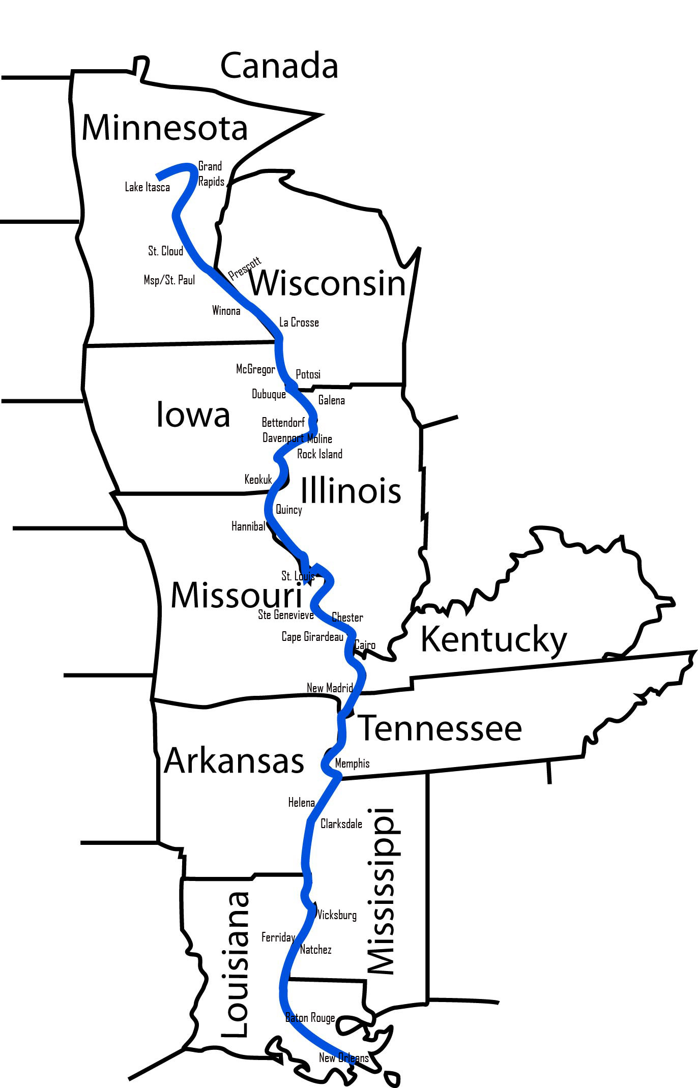
The ten states directly bordered or traversed by the Mississippi River are:
- Minnesota
- Wisconsin
- Iowa
- Illinois
- Missouri
- Kentucky
- Tennessee
- Arkansas
- Mississippi
- Louisiana
These states, often referred to as the “Mississippi River Corridor,” share a common heritage tied to the river, yet each contributes a distinct character to this grand natural landmark. The river acts as a dynamic border for several of these states, fundamentally shaping their geographical and cultural identities.
Tracing the Upper Mississippi: Northern Grandeur
The Upper Mississippi River, extending from its headwaters to the confluence with the Ohio River near Cairo, Illinois, is characterized by its dramatic bluffs, forested islands, and a series of locks and dams that facilitate navigation. This northern stretch reveals the river’s formative power and its intricate relationship with the landscapes it has sculpted.
Minnesota and the Headwaters’ Charm
As the birthplace of the Mississippi River, Minnesota offers a unique perspective on this landmark’s origins. Beyond Lake Itasca, the river winds through dense forests and vast prairies, eventually reaching the major metropolitan areas of Minneapolis and St. Paul. Here, the river transforms into an urban landmark, with St. Anthony Falls in Minneapolis being the only true waterfall on the river, historically crucial for milling and power. The Twin Cities’ skyline framed by the river illustrates the symbiotic relationship between nature and urban development, a testament to the river’s enduring influence.
Navigating Wisconsin, Iowa, and Illinois: Confluence and Agriculture
Downstream from Minnesota, the Mississippi River forms the western border of Wisconsin and the eastern border of Iowa. This section is renowned for its stunning “Driftless Area,” a region untouched by glaciers, resulting in unique geological formations and bluffs. Cities like La Crosse, Wisconsin, and Dubuque, Iowa, stand as historical river towns, their existence tied to the river’s navigation and trade.
Further south, the river forms the western border of Illinois, separating it from Iowa and Missouri. This region is a heartland of agriculture, with vast fields stretching to the riverbanks. The Quad Cities metropolitan area, including Davenport, Iowa, and Moline, Illinois, exemplifies how communities have grown around the river’s industrial and transportation advantages. The river here functions as a vital corridor for shipping agricultural products and other goods, reinforcing its role as an economic landmark.
Significant Landmarks in the North
Beyond the natural beauty, the Upper Mississippi River region boasts several man-made landmarks intrinsically linked to the river. The iconic Gateway Arch in St. Louis, Missouri, stands as a monument to westward expansion, with the river historically serving as the primary highway for pioneers. Many historic riverfront districts, lock and dam structures, and national wildlife refuges like the Upper Mississippi River National Wildlife and Fish Refuge are vital components of this landmark’s narrative, showcasing both human ingenuity and ecological preservation efforts.
The Middle Mississippi: Heartland’s Artery
The Middle Mississippi River stretches from the confluence with the Missouri River near St. Louis to the junction with the Ohio River near Cairo, Illinois. This section is distinct for its robust flow, significant width, and the immense contributions of its major tributaries, solidifying its role as the continent’s primary artery.
Missouri and the Meeting of Waters
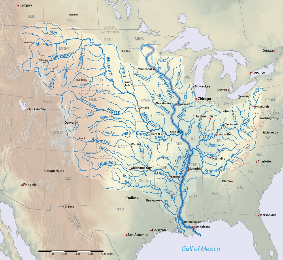
Missouri is a pivotal state along the Mississippi River’s course, particularly notable for the confluence of the Missouri River with the Mississippi. This dramatic meeting point significantly increases the Mississippi’s volume and sediment load, marking a distinct geographical shift. The state’s eastern border is defined by the river, with St. Louis serving as a historical hub for riverine commerce and exploration. The river here symbolizes the convergence of vast watersheds, creating a powerful natural landmark that continues to shape the state’s identity. Further south, towns like Cape Girardeau offer glimpses into the river’s storied past, with historic downtowns and riverfront parks.
Kentucky and Tennessee: Bridging the South
For a relatively short but significant stretch, the Mississippi River forms the western borders of Kentucky and Tennessee. While not as extensively intertwined with these states as others, its presence is profoundly felt. In Kentucky, towns like Hickman and Columbus highlight the historical reliance on river trade. In Tennessee, the river becomes synonymous with the city of Memphis, a cultural landmark renowned for its music heritage and strategic location on a high bluff overlooking the river. The riverfront in Memphis offers panoramic views and serves as a focal point for the city’s identity, with attractions like Mud Island River Park celebrating the river’s history and ecology.
Historical Significance and River Towns
This middle section of the Mississippi River is saturated with history. Towns like Hannibal, Missouri, the boyhood home of Mark Twain, evoke images of steamboats and frontier life, embedding the river deeply into the fabric of American literature and lore. Cairo, Illinois, at the strategic confluence of the Mississippi and Ohio Rivers, was a crucial Civil War-era port, its historical significance a direct result of its riverine location. The river here served as both a barrier and a pathway, influencing military strategies and regional development, making it a critical historical landmark.
Journeying Through the Lower Mississippi: Southern Soul
The Lower Mississippi River, stretching from the Ohio River confluence to the Gulf of Mexico, transforms into a broad, meandering waterway, flanked by the flat, fertile lands of the Mississippi Delta. This segment is characterized by its powerful current, vast floodplains, and deep cultural ties to the American South.
Arkansas and Mississippi: Delta Rhythms
The Mississippi River forms the entire eastern border of Arkansas and the western border of the state of Mississippi. This region is the heart of the Mississippi Delta, a historically and culturally rich area known for its blues music, fertile farmlands, and complex social history. Cities like Greenville, Mississippi, and Helena-West Helena, Arkansas, are deeply intertwined with the river, embodying the resilience and spirit of the Delta. The river here is not just a geographical boundary but a cultural artery, shaping economies and artistic expressions, making it an indispensable cultural landmark.
Louisiana and the Final Stretch: New Orleans and the Delta
As the Mississippi River enters Louisiana, its character dramatically shifts. It becomes the lifeblood of the state, defining its unique geography and culture. The river meanders significantly, eventually splitting into multiple distributaries as it approaches the Gulf of Mexico, forming one of the world’s largest deltas. The iconic city of New Orleans, often called the “Crescent City” due to its bend along the river, is perhaps the most famous urban landmark directly shaped by the Mississippi. Its levee system, port activity, and historic French Quarter all speak to its inseparable connection to the river. The river’s final journey through Louisiana is a dynamic landscape of wetlands, bayous, and barrier islands, a testament to its immense power in shaping coastlines and supporting a delicate ecosystem.
Ecological Wonders and Iconic Cities
The Lower Mississippi River is a biodiversity hotspot, supporting vast populations of fish, birds, and other wildlife. Landmarks like the Vicksburg National Military Park in Mississippi highlight the strategic importance of the river during the Civil War, while cities such as Natchez, Mississippi, and Baton Rouge, Louisiana, showcase antebellum architecture and river-dependent industries. The extensive system of levees, spillways (like the Bonnet Carré Spillway), and the control structures for the Atchafalaya River are monumental engineering landmarks designed to manage the river’s power and protect downstream communities, particularly New Orleans.
The Mississippi’s Enduring Legacy as a Landmark
The Mississippi River is far more than a geographical line on a map; it is a living, breathing landmark that has profoundly influenced the physical, cultural, and historical landscape of the United States. Its journey through ten states underscores its vast reach and the shared responsibility of preserving this national treasure.
A Lifeline for Biodiversity
As a natural landmark, the Mississippi River and its floodplain provide critical habitat for an incredible array of plant and animal species. It serves as a major migratory bird flyway, a breeding ground for fish, and a home for diverse aquatic life. The ecological health of the river is a constant focus of conservation efforts, recognizing its immense value as a natural resource and a vital component of the continent’s biodiversity. Protecting this landmark ensures the survival of countless species and the integrity of a vast ecosystem.
A Historical and Cultural Tapestry
From the indigenous cultures that thrived along its banks for millennia to the European explorers, fur traders, steamboat captains, and civil rights leaders, the Mississippi River has been a silent witness and an active participant in the unfolding drama of American history. It shaped transportation, commerce, and settlement patterns, influencing everything from regional dialects to architectural styles. Its historical significance as a route for exploration, a battleground for conflict, and a source of inspiration for art and music renders it an irreplaceable cultural landmark.

Preserving a National Treasure
The task of managing and preserving the Mississippi River is a colossal undertaking, involving multiple states, federal agencies, and countless local communities. As a landmark, its future hinges on sustainable practices that balance economic development with ecological protection. Understanding its course through Minnesota, Wisconsin, Iowa, Illinois, Missouri, Kentucky, Tennessee, Arkansas, Mississippi, and Louisiana is the first step in appreciating its profound impact and ensuring its grandeur endures for future generations. The Mississippi River remains a majestic landmark, a testament to the raw power of nature and the intricate ways it has shaped a nation.
LifeOutOfTheBox is a participant in the Amazon Services LLC Associates Program, an affiliate advertising program designed to provide a means for sites to earn advertising fees by advertising and linking to Amazon.com. Amazon, the Amazon logo, AmazonSupply, and the AmazonSupply logo are trademarks of Amazon.com, Inc. or its affiliates. As an Amazon Associate we earn affiliate commissions from qualifying purchases.