
The Hawaiian Islands represent one of the most geographically isolated and geologically fascinating regions in the United States. Formed by a “hotspot” in the Earth’s mantle, this archipelago in the Pacific Ocean is a living laboratory of volcanic evolution. When people ask, “What volcano in Hawaii is erupting?” the answer usually centers on the Big Island, home to five major volcanoes. However, the focus almost always rests on Kilauea, which has maintained a near-constant state of activity for decades, and Mauna Loa, the largest subaerial volcano on the planet.
These natural landmarks are not merely geological features; they are the heart of Hawaii Volcanoes National Park, a site recognized globally for its historical, cultural, and scientific importance. Understanding which volcano is currently active requires a look into the rhythmic cycles of these massive shield volcanoes and the unique ways they shape the Hawaii landscape.

Kilauea: The Shield Volcano that Never Sleeps
Kilauea is often cited as the most active volcano in the world. Located on the southeastern shore of the Big Island, it is significantly younger than its massive neighbor, Mauna Loa, yet it is far more frequent in its eruptive behavior. For most of the late 20th and early 21st centuries, Kilauea was in a state of continuous eruption, creating new land and redefining the island’s coastline.
The Dynamics of the Halemaumau Crater
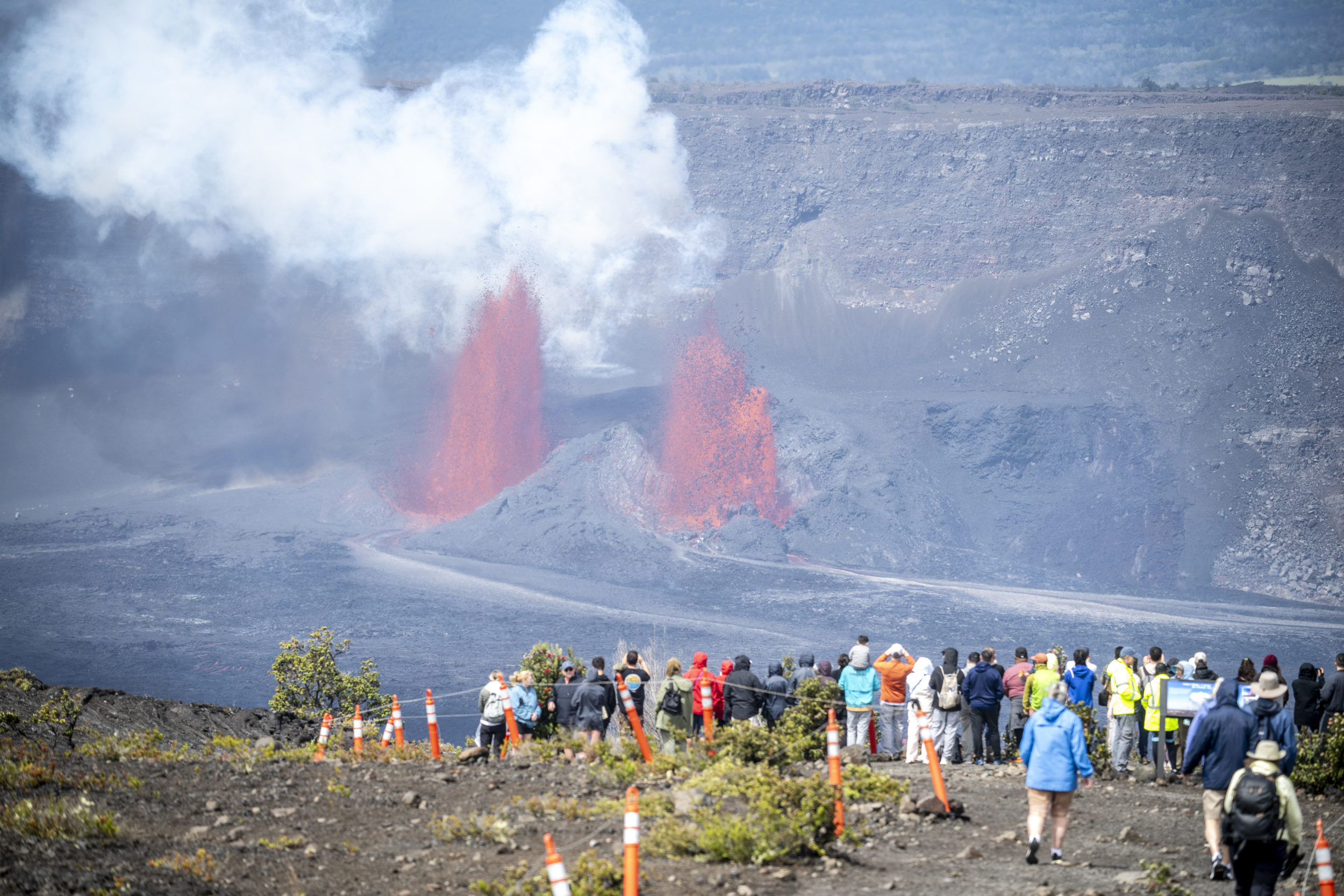
At the summit of Kilauea lies the Kilauea Caldera, and within that caldera sits the Halemaumau Crater. This specific site is the traditional home of Pele, the Hawaiian deity of fire and volcanoes. In recent years, the Halemaumau Crater has been the primary site of activity. Following the massive collapse of the caldera floor in 2018, the crater has seen several episodes of lava lake formation.
When Kilauea is erupting today, it often manifests as a glowing lake of molten rock deep within this crater. These summit eruptions are typically contained, meaning the lava remains within the deep depression of the crater rather than threatening nearby residential areas like Volcano Village. For visitors and scientists, the Halemaumau Crater serves as a window into the Earth’s interior, offering a spectacular display of fountaining lava and volcanic gas emissions.
Historical Eruptions and the Puu Oo Vent
While the summit is the current focus, Kilauea is also famous for its rift zones. The East Rift Zone was the site of the incredibly long-lived eruption of Puu Oo, which began in 1983 and continued almost uninterrupted until 2018. During this period, lava flows from Puu Oo frequently reached the ocean, creating dramatic “steam plumes” and adding hundreds of acres of new land to the island.
The landmark landscape of the Chain of Craters Road bears the scars of these historical flows. As you travel down this road toward the coast, you can see where various eruptions have crossed the asphalt, effectively ending the road’s progress. This area showcases the sheer power of Kilauea to reshape the earth, turning lush forests into desolate, yet beautiful, fields of hardened basalt.
Mauna Loa: Monitoring the Giant of the Pacific
If Kilauea is the most active, Mauna Loa is undoubtedly the most imposing. Rising more than 13,000 feet above sea level—and extending even further to the ocean floor—it is the largest active volcano on Earth. When Mauna Loa erupts, the scale of the event is significantly larger than the typical summit activity seen at Kilauea.
Understanding the Largest Active Volcano on Earth
Mauna Loa covers half of the Big Island. Its name, which means “Long Mountain,” is an accurate description of its sprawling profile. Unlike the steep, conical peaks found in the Andes or the Cascades, Mauna Loa is a shield volcano, characterized by broad, gentle slopes created by the eruption of fluid basaltic lava.
Because of its size and the volume of lava it can produce, Mauna Loa is closely monitored by the Hawaiian Volcano Observatory. While it erupts less frequently than Kilauea, its eruptions can be much more high-volume. The history of Mauna Loa includes flows that have reached the outskirts of Hilo on the east side and threatened the coastal resorts of Kona on the west.
The 2022 Eruption and Its Impact on the Landscape
After 38 years of quiet, Mauna Loa erupted in late 2022. This event drew global attention to the landmark as lava fountained from the summit caldera, Moku aweoweo, and eventually migrated to the Northeast Rift Zone. The 2022 eruption was a reminder of the volcano’s potential; lava flows moved toward the Saddle Road, a major highway connecting Hilo and Kona.
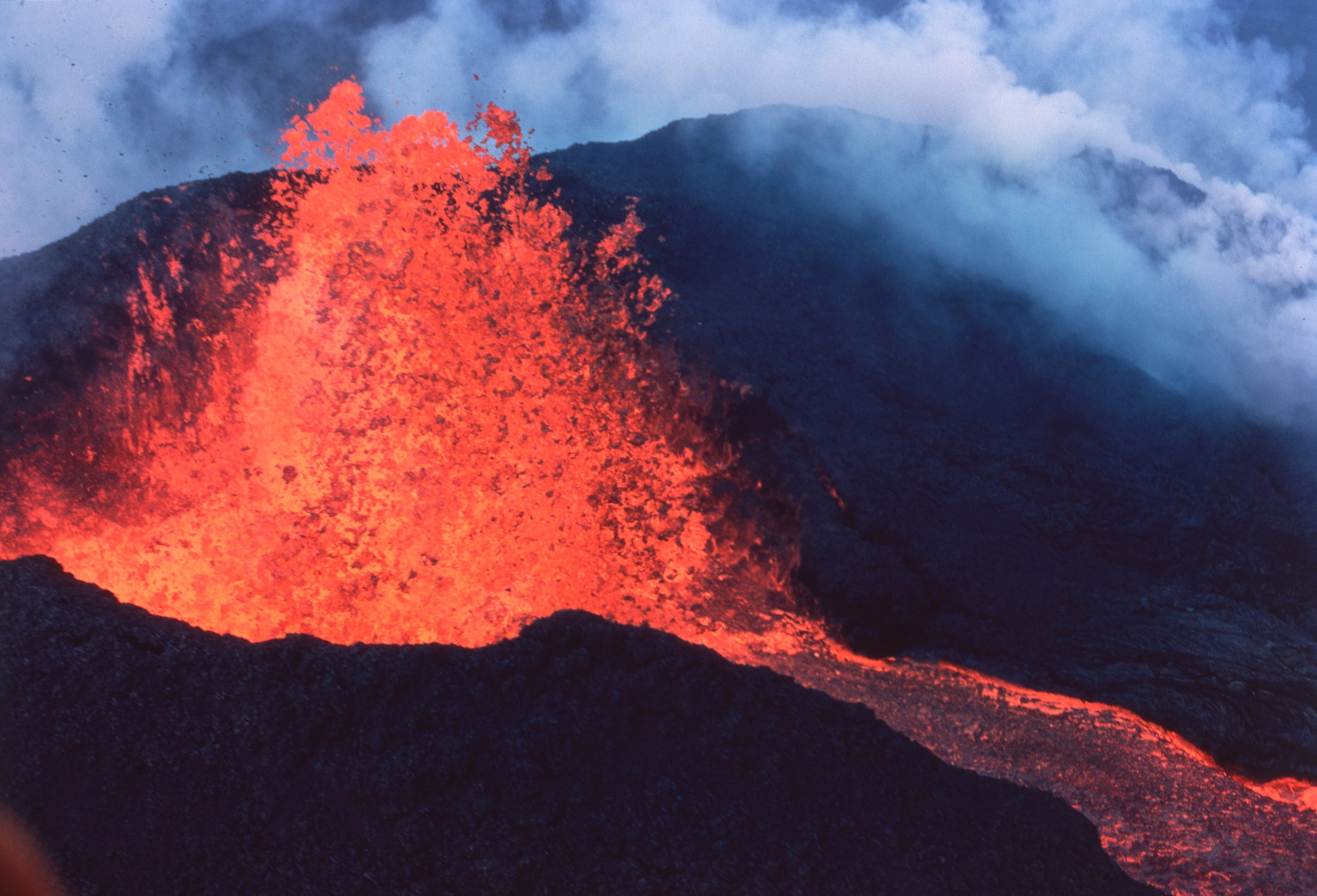
Though the eruption eventually ceased before reaching the highway, it left behind fresh flows of “a’a” and “pahoehoe” lava, names given to the two primary types of volcanic rock found in Hawaii. This recent activity has reinforced Mauna Loa as a dynamic landmark that remains a central figure in the geological narrative of the Pacific Ocean.
Hawaii Volcanoes National Park: A Living Landmark
Most of the volcanic activity in Hawaii takes place within the boundaries of Hawaii Volcanoes National Park. Established in 1916, the park is a sanctuary for both natural wonders and historical sites. It offers a rare opportunity for people to witness the primary processes of land formation.
Geologic Wonders Beyond the Lava
While the flowing lava is the main attraction, the park contains numerous other landmarks that are equally significant. The Thurston Lava Tube, also known as Nahuku, is a massive underground cave formed by a river of molten rock. Visitors can walk through this prehistoric-looking tunnel, which is surrounded by a lush tropical fern forest, illustrating the stark contrast between the island’s volcanic origins and its vibrant ecosystem.
Another notable landmark is Kilauea Iki. In 1959, this side crater erupted in a spectacular display, sending lava fountains hundreds of feet into the air. Today, the Kilauea Iki Trail allows hikers to descend onto the solidified lake of lava, where steam still rises from cracks in the ground, reminding everyone that the earth beneath remains incredibly hot.
Preserving the Cultural History of the Volcanic Peaks
The volcanoes of Hawaii are not just geological landmarks; they are sacred sites in the indigenous culture of the islands. For Native Hawaiians, these mountains are “wahi pana” (sacred places). The preservation of these sites within the Hawaii Volcanoes National Park ensures that the spiritual and cultural history associated with the peaks—such as the chants and stories of Pele—remains central to the visitor experience.
Archaeological sites, including ancient petroglyphs at Puuloa, can be found within the park. These carvings into the volcanic rock provide a glimpse into the lives of the early inhabitants who lived in the shadow of these erupting giants. The intersection of history and geology makes these landmarks some of the most complex and meaningful sites in the United States.
The Science and Observation of Hawaii’s Volcanic Activity
The question of which volcano is erupting is constantly answered by the Hawaiian Volcano Observatory (HVO). Founded in 1912 by Thomas A. Jaggar, the HVO was the first of its kind in the nation. It serves as the primary source for monitoring the activity of Kilauea, Mauna Loa, Mauna Kea, Hualalai, and Kohala.
The Role of the Hawaiian Volcano Observatory
The HVO uses a sophisticated array of seismometers, GPS stations, and gas sensors to track the movement of magma beneath the surface. This scientific landmark—though its physical headquarters near the Jaggar Museum was damaged during the 2018 eruption—remains the authority on volcanic safety. Their work allows the public to know in real-time which volcano is currently active and whether an eruption poses any threat to the surrounding landmarks or communities.
By monitoring the “inflation” and “deflation” of the volcanoes, scientists can often predict when an eruption is imminent. This level of oversight has made Hawaii one of the safest places in the world to observe volcanic activity, as the HVO provides clear updates and warnings to the National Park Service.
Navigating the Landmarks Safely
For those interested in witnessing an eruption, the landmarks within the park offer various vantage points. The Steaming Bluffs and the Sulphur Banks provide a sensory experience of the volcano’s power, as volcanic gases and steam rise directly from the earth. The Devastation Trail offers a walk through a landscape buried by cinder and ash from the 1959 eruption, showing how quickly a forest can be transformed.
Observing an active eruption requires respect for the natural environment. The volcanic gases, particularly “vog” (volcanic smog), can affect air quality across the Big Island and even reach as far as Honolulu. The presence of these gases is a constant reminder that these landmarks are breathing, living entities that continue to build the very land upon which we stand.
In conclusion, whether it is the persistent glow within Kilauea or the massive, infrequent awakenings of Mauna Loa, the volcanoes of Hawaii are landmarks of unparalleled significance. They represent the ongoing creation of the world, offering a unique blend of scientific marvel, cultural depth, and breathtaking natural beauty. By understanding the cycles of these volcanoes, one can better appreciate the dynamic history of the Hawaiian Islands and the powerful forces that continue to shape our planet.
LifeOutOfTheBox is a participant in the Amazon Services LLC Associates Program, an affiliate advertising program designed to provide a means for sites to earn advertising fees by advertising and linking to Amazon.com. Amazon, the Amazon logo, AmazonSupply, and the AmazonSupply logo are trademarks of Amazon.com, Inc. or its affiliates. As an Amazon Associate we earn affiliate commissions from qualifying purchases.