
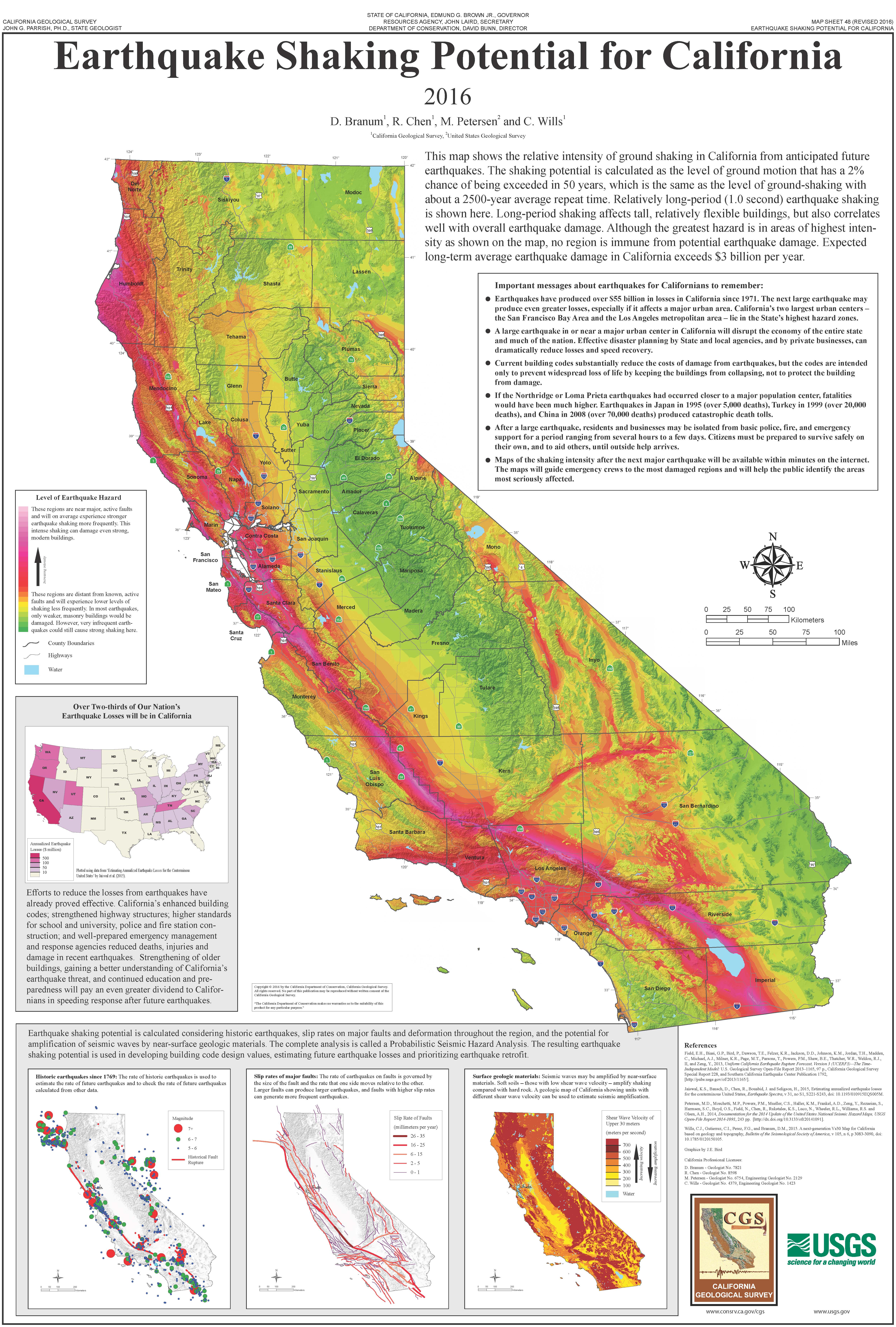
California, a state synonymous with dramatic landscapes and vibrant culture, also carries a geological legacy that shapes its identity. The very ground beneath its sprawling cities and iconic landmarks holds a powerful history, punctuated by seismic events that have left indelible marks. For travelers and enthusiasts of California‘s unique character, understanding these significant earthquakes is not just about historical curiosity; it’s about appreciating the resilient spirit of the places they explore and the forces that continue to shape the Golden State. While the term “the big earthquake” can refer to several pivotal moments, one event overwhelmingly dominates this descriptor: the devastating 1906 San Francisco earthquake. However, to truly grasp California’s seismic narrative, we must also consider other influential tremors that have punctuated its history and continue to inform its present.
The Great 1906 San Francisco Earthquake: A Cataclysmic Event
The predawn hours of April 18, 1906, marked a profound turning point for California. At approximately 5:12 AM Pacific Time, a massive earthquake, estimated to have a magnitude of 7.9, violently shook the region. Its epicenter was located just offshore, near San Francisco, but the rupture extended for an astonishing 296 miles along the San Andreas Fault. The shaking itself was intense, lasting for nearly a minute, causing widespread destruction. Buildings swayed, then crumbled, sending debris and terrified residents into the streets. However, the earthquake was only the prelude to a far greater catastrophe: the ensuing fires.
The Devastation of Fire and Its Aftermath
The earthquake ruptured gas lines and water mains throughout San Francisco. With water systems compromised and the city’s dense wooden structures providing ample fuel, fires quickly ignited. These blazes raged for three days, consuming an estimated 4.7 square miles of the city, leaving over 250,000 people homeless and destroying approximately 28,000 buildings. The iconic Palace Hotel, a beacon of luxury at the time, was severely damaged, as were countless other landmarks and businesses. The economic impact was staggering, estimated at over $400 million in 1906 dollars, equivalent to billions today.
The loss of life was initially estimated to be around 370, but modern scholarship suggests the true figure may have been significantly higher, possibly exceeding 3,000. The human toll, coupled with the sheer scale of destruction, etched the 1906 earthquake into the collective memory of California and the nation. The rebuilding of San Francisco became a monumental undertaking, a testament to the resilience of its people and a catalyst for more stringent building codes and urban planning. This event fundamentally altered how Californians viewed their relationship with the earth beneath them, fostering a heightened awareness of seismic risk.
Beyond 1906: Other Significant California Earthquakes
While the 1906 earthquake often takes center stage, California‘s seismic history is a tapestry woven with numerous other significant events. These tremors, though perhaps less cataclysmic in their immediate impact, have nonetheless played crucial roles in shaping the state’s landscape, its infrastructure, and the ongoing scientific study of earthquakes.
The 1989 Loma Prieta Earthquake: A Modern Scare
More than eight decades after the 1906 San Francisco earthquake, another powerful tremor brought seismic fears to the forefront. On October 17, 1989, at 5:04 PM Pacific Time, the Loma Prieta earthquake, with a magnitude of 6.9, struck the San Francisco Bay Area. The epicenter was in the Santa Cruz Mountains, a region about 60 miles south of San Francisco. This earthquake famously interrupted the third game of the 1989 World Series between the San Francisco Giants and the Oakland Athletics at Candlestick Park, an event that was broadcast live to millions, underscoring the earthquake’s national reach.
Impact and Lessons Learned
The Loma Prieta earthquake caused significant damage, particularly in the cities of Santa Cruz, Watsonville, and San Francisco. It led to the collapse of the Cypress Street Viaduct on Interstate 880 in Oakland, killing 42 people and igniting a widespread debate about the safety of the state’s aging infrastructure. The iconic Golden Gate Bridge and San Francisco-Oakland Bay Bridge also sustained damage, though miraculously, they remained standing. The earthquake resulted in 63 deaths and billions of dollars in damages.

The Loma Prieta earthquake served as a stark reminder that seismic threats in California were ongoing and that preparedness was paramount. It spurred further research into seismic retrofitting of bridges and buildings, leading to significant improvements in seismic safety standards and a renewed emphasis on disaster preparedness for both individuals and government agencies. The scientific community also benefited from the data collected, enhancing our understanding of fault behavior and seismic wave propagation.
The 1994 Northridge Earthquake: Los Angeles Under Threat
The San Francisco Bay Area was not the only region to experience devastating seismic activity. On January 17, 1994, at 4:31 AM Pacific Time, the Northridge earthquake, with a magnitude of 6.7, struck the San Fernando Valley in Los Angeles. This earthquake occurred on a previously unmapped blind thrust fault beneath the Santa Susana Mountains, demonstrating that seismic hazards could arise from unexpected sources.
Widespread Destruction in Southern California
The Northridge earthquake caused widespread destruction across Los Angeles County, with particularly severe damage in the Northridge and Reseda areas. The shaking caused the collapse of numerous overpasses and underpasses on the Los Angeles freeway system, including sections of Interstate 5 and State Route 101. The damage to transportation infrastructure paralyzed parts of the region for weeks. Residential areas also suffered immense damage, with thousands of homes destroyed or rendered uninhabitable due to collapsed walls and damaged foundations.
The earthquake resulted in 57 deaths and an estimated $20 billion in damages, making it one of the most costly natural disasters in U.S. history at the time. The Northridge earthquake highlighted the vulnerability of urban areas to earthquakes originating from shallow, inland faults. It led to significant advancements in seismic building codes, particularly for steel-frame buildings, and reinforced the importance of emergency preparedness in densely populated metropolitan areas. The event also spurred further investment in seismic monitoring and research, including the establishment of the Southern California Earthquake Center.
Understanding California’s Seismic Landscape for Travelers
For anyone planning a trip to California, understanding its seismic history is an integral part of appreciating its resilience and unique character. While the prospect of an earthquake can be daunting, it’s important to remember that California is one of the most studied and prepared regions in the world for seismic events.
Preparing for Your California Adventure
Modern infrastructure in California is built with seismic considerations in mind. Hotels, attractions, and transportation networks adhere to stringent building codes designed to withstand significant shaking. When visiting, familiarize yourself with your accommodation’s emergency procedures. Many hotels provide earthquake preparedness information upon check-in.

Key Tourist Destinations and Their Seismic Context
From the iconic Golden Gate Bridge in San Francisco to the vibrant streets of Los Angeles, and the stunning natural beauty of Yosemite National Park, California offers an unparalleled array of experiences. While these destinations are geologically active regions, they are also sites of incredible human achievement and natural wonder that have endured and thrived. Visiting these places offers a chance to connect with the history, culture, and the very earth that shapes California. Engaging with the state’s seismic past through its landmarks and historical sites provides a deeper appreciation for its ongoing story of resilience and adaptation. For instance, a visit to the California Academy of Sciences in San Francisco often includes exhibits detailing the 1906 earthquake, offering an educational perspective on seismic events. Similarly, understanding the geological forces that shaped the dramatic coastlines and mountain ranges adds another layer of wonder to any exploration.
The continuous scientific monitoring and public awareness campaigns in California mean that residents and visitors are increasingly informed and prepared. By understanding the history of “the big earthquakes” in California, travelers can embark on their journeys with a greater sense of context and respect for the powerful natural forces that have shaped, and continue to shape, this dynamic state.
LifeOutOfTheBox is a participant in the Amazon Services LLC Associates Program, an affiliate advertising program designed to provide a means for sites to earn advertising fees by advertising and linking to Amazon.com. Amazon, the Amazon logo, AmazonSupply, and the AmazonSupply logo are trademarks of Amazon.com, Inc. or its affiliates. As an Amazon Associate we earn affiliate commissions from qualifying purchases.