
California is a land shaped by dramatic geological forces, a vibrant tapestry of mountains, valleys, and coastlines, all defined by its intricate network of fault lines. These natural landmarks are not merely lines on a map; they are the architects of the state’s iconic landscapes, dictating everything from its famous mountain ranges to its fertile valleys. Understanding where these seismic scars lie offers profound insight into the very foundation of California’s natural grandeur and its dynamic, ever-evolving character.
The San Andreas Fault: California’s Most Famous Landmark
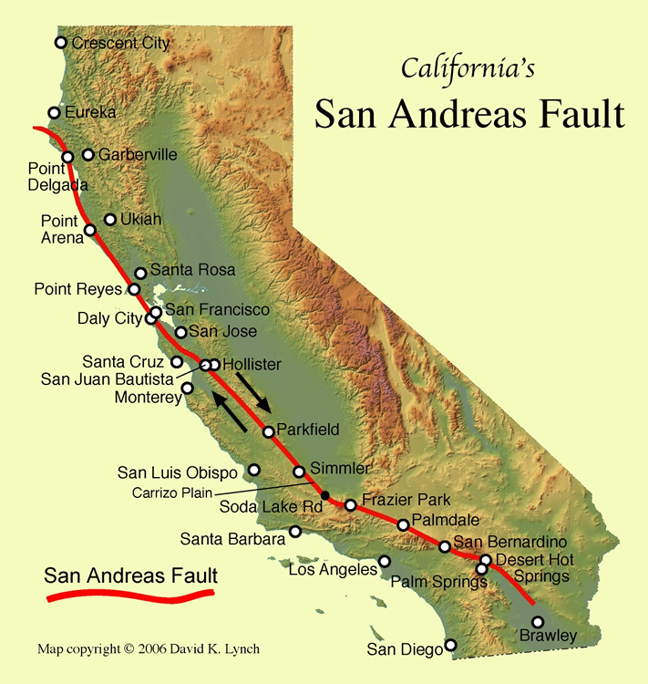
No discussion of California’s geological landmarks is complete without beginning with the San Andreas Fault. This colossal right-lateral strike-slip fault is arguably the most famous and significant geological feature in North America. Spanning approximately 800 miles from the Salton Sea in the south to Cape Mendocino in the north, it marks the primary boundary between the Pacific Plate and the North American Plate. Along this boundary, these two immense slabs of the Earth’s crust grind past each other, creating the seismic activity for which California is renowned.
Tracing the Rift: From Northern to Southern California
The San Andreas Fault carves a distinct path across the state, creating observable topographic features that serve as striking natural landmarks. In Northern California, the fault runs offshore for a stretch before reappearing inland, notably responsible for the formation of Tomales Bay and the dramatic landscapes of the Point Reyes National Seashore. Here, visitors can see the clear evidence of tectonic movement in offset fences and trails, offering tangible proof of the Earth’s constant motion.
As it extends south, the fault passes through the sparsely populated Diablo Range before reaching Parkfield, often dubbed the “earthquake capital of the world” due to its frequent, albeit generally small, seismic events. This area is a crucial site for geological research and serves as an informal landmark for those interested in active fault mechanics. Further south, the fault becomes a profoundly visible scar across the Carrizo Plain National Monument in San Luis Obispo County. The prominent Wallace Creek site within the monument offers one of the most remarkable and accessible examples of a stream channel offset by continuous fault movement over millennia, a truly astonishing landmark of geological time. The distinctive “fault trace” is visible from space, appearing as a long, linear valley and ridge system.
Entering Southern California, the San Andreas Fault runs along the base of the San Gabriel Mountains and the Mojave Desert, shaping the terrain around major population centers like Los Angeles. It continues southeast into the Coachella Valley, passing near Palm Springs before submerging beneath the Salton Sea, a vast, landlocked body of water whose very existence is tied to the fault’s subsidence.
Observable Features and Geological Significance
The San Andreas Fault is not just a line; it’s a zone of intense deformation. Its path is often marked by distinctive landforms, including sag ponds (depressions where the ground has subsided), linear valleys, offset stream channels, and pressure ridges. These features, visible to the discerning eye, are natural landmarks that tell the story of the Earth’s immense power. For hikers and geology enthusiasts, exploring areas like the Carrizo Plain provides an unparalleled opportunity to walk directly upon and observe the physical manifestations of this tectonic boundary, offering a unique landmark experience unlike any other. The fault’s geological significance lies not only in its visible impact but also in its role as the primary driver of the state’s seismic activity, shaping everything from its topographical relief to its mineral resources.
Major Subsidiary Fault Systems
While the San Andreas Fault is the dominant player, California is crisscrossed by numerous other significant fault systems. These subsidiary faults are often branches or parallel segments that accommodate the complex stresses generated by the interaction of the Pacific and North American Plates. Many of these are active and contribute significantly to the state’s seismic profile, acting as equally important, albeit sometimes less famous, geological landmarks.
The Hayward Fault: An Urban Landmark
Running through the densely populated San Francisco Bay Area, the Hayward Fault is one of the most active and urbanized fault lines in the United States. It parallels the San Andreas Fault and extends for about 74 miles, passing directly beneath cities such as Fremont, Hayward, Oakland, and Berkeley. What makes the Hayward Fault a unique landmark is its observable “creeping” behavior. Unlike faults that store stress and release it in large earthquakes, parts of the Hayward Fault move continuously, albeit slowly. This creep is evident in offset curbs, cracked sidewalks, and even structurally damaged buildings in urban areas, making it a living, breathing geological landmark integrated into the daily lives of millions. Visitors can observe these subtle but clear signs in places like the University of California, Berkeley campus or downtown Hollister, where buildings are literally being pulled apart by the slow, relentless movement of the Earth.
The Garlock Fault: A Left-Lateral Anomaly
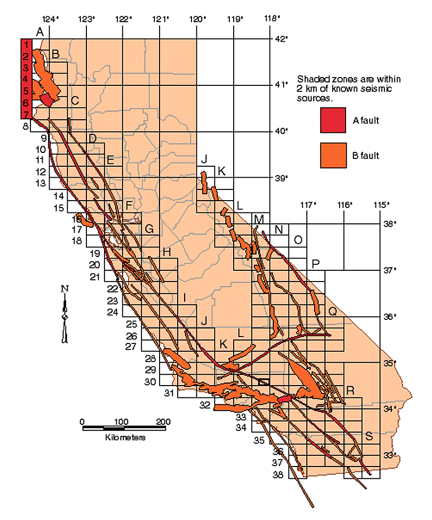
Cutting across the southern edge of the Sierra Nevada and into the Mojave Desert, the Garlock Fault presents a fascinating anomaly. It is a left-lateral strike-slip fault, meaning the block of land on the opposite side moves to the left relative to an observer. This is contrary to the right-lateral movement of the San Andreas Fault and most other major faults in California. Stretching approximately 160 miles, the Garlock Fault connects the San Andreas Fault to the system of faults in Nevada. Its linear expression across the desert floor, particularly visible from aerial views, makes it a significant geological landmark, showcasing the complex dance of tectonic forces. Remote but starkly beautiful, it highlights the diversity of faulting styles within the state.
The Elsinore and San Jacinto Faults: Southern California’s Dynamic Duo
In Southern California, two other major fault systems run roughly parallel to the San Andreas Fault: the Elsinore Fault and the San Jacinto Fault. Both are significant right-lateral strike-slip faults, contributing substantially to the region’s seismic activity.
The San Jacinto Fault is considered one of the most active faults in California, extending for about 130 miles from the San Bernardino Mountains southeast through the Imperial Valley. Its path creates distinct geological features, including sag ponds and linear valleys, making it a prominent landmark for geological exploration. Portions of the fault are visible within Anza-Borrego Desert State Park, where visitors can hike through landscapes directly shaped by its movement.
The Elsinore Fault, slightly less active but still a major player, runs for about 110 miles, primarily forming the southwestern boundary of the Peninsular Ranges in Southern California. It is responsible for creating the Elsinore Trough and its associated lakes. Both the Elsinore and San Jacinto faults are critical components of California’s active geological landscape, each carving out its own distinct landmark features in the diverse terrain.
Understanding Fault Line Landscapes and Their Impact
The presence of these extensive fault systems has profoundly shaped California’s topography, creating a diverse array of natural landmarks that range from rugged mountain ranges to fertile valleys and unique hydrological features. The relentless movement along these faults is the primary force behind the state’s dramatic relief.
Scenic Beauty Forged by Tectonic Forces
Many of California’s most celebrated natural landmarks owe their existence to fault activity. The Transverse Ranges, including the San Gabriel Mountains and San Bernardino Mountains, are uplifted blocks resulting from complex faulting. The deep valleys that crisscross the state, such as the Coachella Valley and parts of the Great Central Valley, are often grabens or down-dropped blocks between fault zones. Even the stunning coastline, particularly areas like Big Sur, is a product of ongoing tectonic uplift and erosion along numerous coastal faults. These geological processes have sculpted the iconic landscapes that draw visitors from around the world, making the fault lines themselves the silent, powerful sculptors of California’s most famous landmarks.
Visiting Fault Zones: Educational Opportunities
For those interested in the raw power of nature, visiting visible fault zones offers an unparalleled educational experience. Designated parks and open spaces frequently feature interpretive trails and signage that explain the geology. The Carrizo Plain National Monument is a prime example, allowing visitors to hike along the very trace of the San Andreas Fault and witness its dramatic effects. Similarly, Anza-Borrego Desert State Park provides excellent opportunities to observe the San Jacinto Fault and other related geological features. Even urban environments offer insights, with the creeping effects of the Hayward Fault acting as a constant, subtle reminder of the Earth’s movement. These locations serve as living laboratories and accessible landmarks for understanding plate tectonics.
Preparing for the Unseen: Living with Active Landmarks
Living and visiting California means coexisting with these active geological landmarks. While the focus here is on their role as landscape architects, understanding their presence also underpins the state’s approach to infrastructure, building codes, and emergency preparedness. The knowledge of where these fault lines lie guides decisions on land use and construction, ensuring that the human landscape can endure the dynamic forces of the natural landscape.

Geological Tours and Interpretive Centers
To truly appreciate these natural landmarks, numerous geological tours and interpretive centers across California provide invaluable context. From guided excursions along the San Andreas Fault near Palm Springs to museums like the California Academy of Sciences in San Francisco that feature exhibits on earthquakes and geology, opportunities abound for deeper engagement. The Geysers Geothermal Field in Sonoma County, though not a fault line itself, is another landmark powered by the deep heat associated with tectonic activity. These resources enhance the visitor’s understanding, transforming abstract geological concepts into tangible, awe-inspiring experiences with the Earth’s enduring power. By identifying and interpreting these fault lines, California not only acknowledges its active geology but celebrates it as an integral part of its identity and its spectacular natural landmarks.
LifeOutOfTheBox is a participant in the Amazon Services LLC Associates Program, an affiliate advertising program designed to provide a means for sites to earn advertising fees by advertising and linking to Amazon.com. Amazon, the Amazon logo, AmazonSupply, and the AmazonSupply logo are trademarks of Amazon.com, Inc. or its affiliates. As an Amazon Associate we earn affiliate commissions from qualifying purchases.