
The Mississippi River stands as the singular most iconic waterway in the United States. Spanning over 2,300 miles from its humble beginnings to the vast Gulf of Mexico, it has served as the lifeblood of American commerce, culture, and exploration. Yet, for all its majesty, the river begins its journey in a surprisingly understated fashion. To find the true headwaters, one must journey to the heart of the north woods in the state of Minnesota.
The Sacred Source at Lake Itasca
The official headwaters of this mighty river are located within Itasca State Park, the oldest state park in Minnesota. Established in 1891 to preserve the virgin pine forests surrounding the source, this protected landmark offers a profound look at the geographical origins of a continental giant.
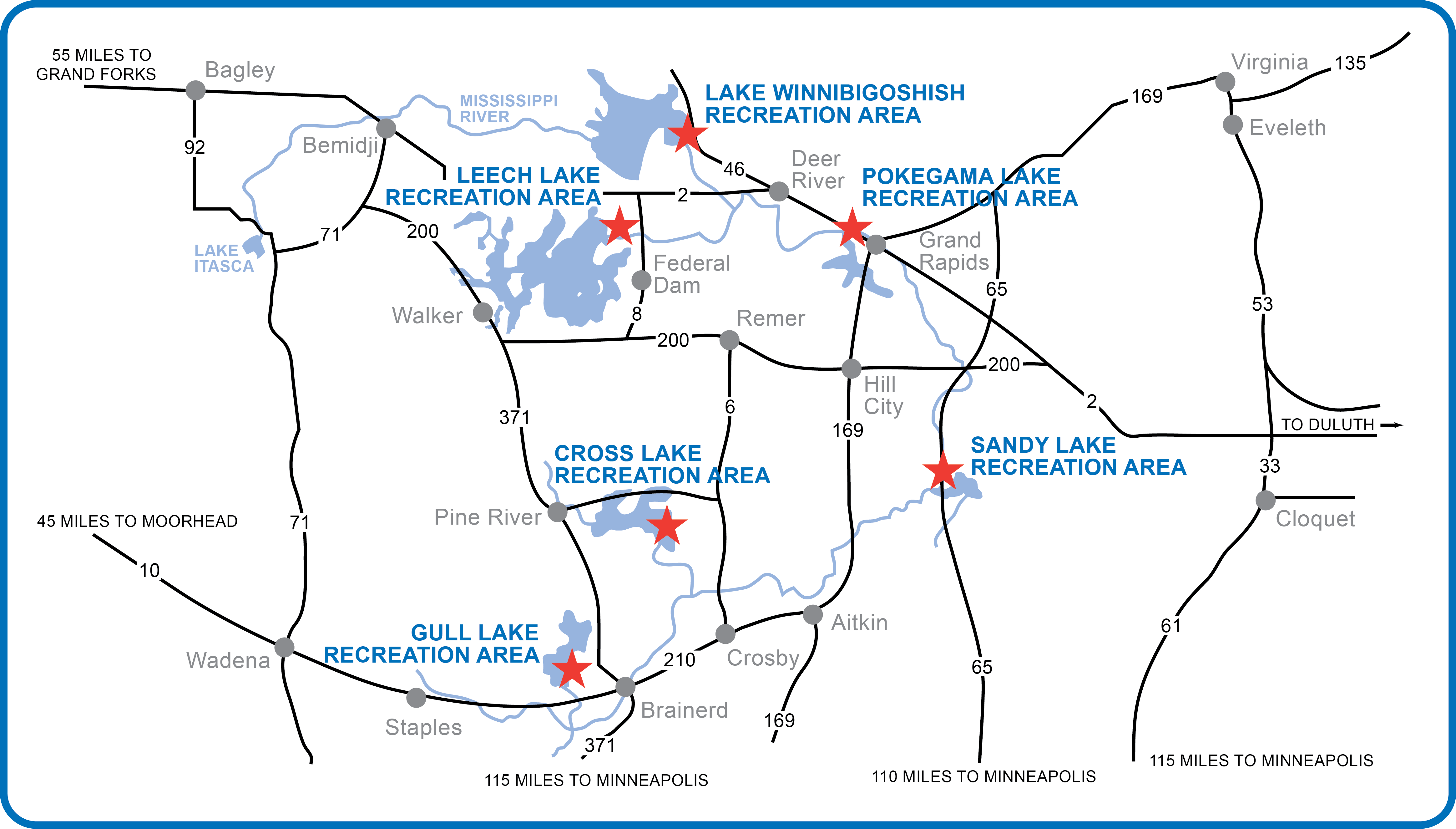
Geography of the Headwaters
The river emerges from Lake Itasca, a relatively small glacial lake nestled in the moraines of north-central Minnesota. Unlike the raging, silt-heavy currents seen in New Orleans or St. Louis, the water at the start is crystal clear and remarkably shallow. As it spills over a man-made rock dam at the northern end of the lake, the river is so narrow that it barely reaches ankle depth, allowing visitors to walk across the Mississippi on stones in just a few short strides.
The Significance of Schoolcraft Island
While many tourists congregate at the immediate rock-strewn outlet, the broader area known as Schoolcraft Island holds historical weight. Named after Henry Rowe Schoolcraft, the explorer who identified the lake as the true source in 1832, the island remains a focal point for those interested in the scientific and cartographic history of the North American interior. The area surrounding the lake serves as a living museum, demonstrating how glaciers shaped the landscape thousands of years ago, creating the kettle lakes and ridges that define the region.
The Historical Quest for the Source
Before the official designation of the headwaters, the quest to locate the Mississippi’s beginning was a subject of intense scientific and political debate. Explorers spent decades pushing through the dense forests of the Upper Midwest, battling harsh winters and conflicting geographical data.
Early European Exploration
European interest in the river began long before the source was verified. Explorers like Hernando de Soto reached the lower Mississippi in the 16th century, but the upper reaches remained a mystery to the outside world for centuries. During the 19th century, the United States Army dispatched various expeditions to map the territory, aiming to solidify claims and better understand the topography of the Louisiana Purchase.
Challenges of Mapping the Mississippi
Pinpointing the headwaters was not merely a matter of following the water uphill. The Mississippi is fed by a complex network of streams, marshes, and smaller basins. For years, Cass Lake was incorrectly identified as the source. It was only through the persistent efforts of explorers who navigated the swampy, mosquito-ridden terrain that the definitive link between the streams feeding into Lake Itasca and the wider river channel was finally accepted. This historical struggle highlights the sheer scale of the landscape that the river eventually comes to dominate.
A Destination for Naturalists and Travelers

Beyond its status as a geographical curiosity, the headwaters represent a premier destination for those seeking to reconnect with nature. The environment surrounding the source is a protected sanctuary that offers a glimpse into what the American wilderness looked like before extensive development.
Biodiversity of the Region
The area around the Mississippi headwaters is a rich mosaic of pine, spruce, and hardwood forests. It serves as a vital habitat for a wide array of wildlife. Birdwatchers frequent the area, particularly to spot the Bald Eagle and the Common Loon, the latter of which is a symbol of the Minnesota Northwoods. During the autumn months, the changing leaves transform the park into a tapestry of brilliant oranges and deep reds, reflecting off the calm, dark waters of the lake.
Recreational Opportunities
For the active traveler, the headwaters offer more than just a photo opportunity.
- Hiking: Miles of trails wind around the lake and through the surrounding Itasca Wilderness Sanctuary, providing opportunities for quiet reflection among 300-year-old pine trees.
- Kayaking and Canoeing: Paddling through the narrow, twisting channels of the Upper Mississippi allows visitors to experience the river as early explorers and indigenous peoples did.
- Cycling: The Heartland State Trail and other regional paths provide excellent infrastructure for cyclists looking to explore the rolling terrain of northern Minnesota.
Understanding the Ecological Importance
The headwaters are not just a static landmark; they are the starting point of a complex ecological system that supports millions of lives. The health of the water as it exits Lake Itasca is critical, as it sets the tone for the quality of the ecosystem downstream.
Water Conservation and Quality
Because the Mississippi provides drinking water for dozens of major municipalities, the purity of the source is a matter of national concern. The watershed at the headwaters is carefully managed to prevent runoff and pollution. Organizations work in conjunction with state and federal agencies to ensure that the riparian buffer zones—the vegetation bordering the river—are maintained to filter pollutants.
Indigenous Stewardship
It is impossible to discuss the headwaters without acknowledging the Ojibwe people, who have lived in this region for generations. They understood the significance of this river long before European maps were drawn. To many local indigenous groups, the headwaters represent a sacred intersection of water, earth, and spirit. Visiting this site offers travelers a chance to reflect on the importance of land stewardship and the enduring legacy of the cultures that flourished here long before the modern era.
Planning Your Visit to the Source
Visiting the headwaters of the Mississippi is a rite of passage for many Americans and an intriguing discovery for international tourists. Whether you are driving through the Great Lakes region or planning a dedicated road trip, the experience is best enjoyed with a bit of foresight.
Best Time to Visit
While the park is open year-round, the summer months (June through August) offer the most pleasant weather for outdoor activities. However, those looking to avoid crowds and witness the stunning foliage should consider visiting in late September. Winter brings a serene, frozen stillness to the park, though it requires specialized gear for those wishing to explore the trails.
Accommodations and Nearby Attractions
While staying directly within the park at the historic Douglas Lodge provides an immersive experience, the surrounding towns also offer various amenities. The city of Bemidji, known as the “First City on the Mississippi,” is located just a short drive away. It is home to the famous statues of Paul Bunyan and Babe the Blue Ox, adding a touch of folklore to any trip to the headwaters.
By taking the time to stand at the source, one gains a unique perspective on the power of nature. From a small, quiet outlet in a Minnesota forest to the expansive, bustling mouth at the Gulf of Mexico, the Mississippi River is a testament to the scale and beauty of the American landscape. Identifying the headwaters is merely the first step in understanding the immense journey of this storied river.
LifeOutOfTheBox is a participant in the Amazon Services LLC Associates Program, an affiliate advertising program designed to provide a means for sites to earn advertising fees by advertising and linking to Amazon.com. Amazon, the Amazon logo, AmazonSupply, and the AmazonSupply logo are trademarks of Amazon.com, Inc. or its affiliates. As an Amazon Associate we earn affiliate commissions from qualifying purchases.