
As a vast and geographically diverse state, Oregon offers unparalleled opportunities for outdoor exploration. From the rugged Pacific Coast to the high desert of its eastern regions, and the dense forests of the Cascade Mountains, Oregon’s natural beauty is a significant draw for tourists and travelers alike. However, like many western states, Oregon is increasingly affected by wildfires. Understanding the patterns and potential locations of these events is crucial for planning safe and enjoyable travel experiences. This guide aims to provide insights into where wildfires are most likely to occur in Oregon, focusing on the natural landscapes that define its tourism appeal.
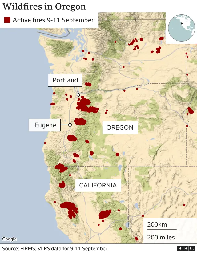
Understanding Oregon’s Wildfire Landscape
Oregon’s topography and climate create a varied wildfire risk across its regions. The state experiences distinct fire seasons influenced by temperature, precipitation, wind, and vegetation type. While wildfires are a natural part of many ecosystems, their intensity and frequency can be exacerbated by human activity and changing climatic conditions. For travelers, being aware of these factors can inform itinerary planning and ensure a more responsible approach to experiencing the state’s natural wonders.
Factors Influencing Wildfire Occurrence
Several key factors contribute to wildfire risk in Oregon. Understanding these elements helps in anticipating potential areas of concern:
- Vegetation Type: Drier forests, particularly those dominated by coniferous trees like ponderosa pine and Douglas fir, are highly susceptible to ignition and rapid fire spread. Areas with dense undergrowth and accumulated dead organic matter (fuel) are also at higher risk.
- Climate and Weather Patterns: Prolonged dry spells, high temperatures, and low humidity create tinderbox conditions. Strong, erratic winds, often associated with Santa Ana or Diablo winds in other regions, can significantly accelerate fire growth and create new ignitions. The inverse is also true; significant rainfall or prolonged wet periods can reduce fire risk.
- Topography: Steep slopes can contribute to faster fire spread as flames preheat fuels upslope. Canyons and ravines can also channel winds, intensifying fire behavior.
- Human Activity: While lightning is a natural ignition source, a significant percentage of wildfires are human-caused. Campfires left unattended, discarded cigarettes, equipment malfunctions, and arson are common culprits. Areas with high recreational use, such as popular hiking trails, campgrounds, and off-road vehicle areas, often face a higher risk of human-caused ignitions.
Seasonal Variations in Fire Risk
The wildfire season in Oregon typically runs from late spring through early fall.
- Spring (April-May): As snowmelt recedes, grasses and brush begin to dry out, especially in lower elevations and drier eastern regions. Early season fires can occur if warm and dry conditions prevail.
- Summer (June-August): This is generally the peak of wildfire season. High temperatures, low humidity, and dry vegetation create ideal conditions for ignition and rapid spread. Large fires are most common during these months.
- Fall (September-October): The risk can persist into the fall, especially if dry conditions continue after the summer months. Cooler temperatures and increased moisture later in the season usually bring the fire season to a close. However, early dry spells and strong winds can still lead to significant fall fires.
High-Risk Fire Zones for Travelers
While wildfires can occur anywhere in Oregon, certain regions and ecosystems are more prone to them due to their natural characteristics and human use patterns. Travelers visiting these areas should remain particularly vigilant and informed.
Eastern Oregon’s High Desert and Steppe
Eastern Oregon is characterized by its arid climate, vast expanses of sagebrush steppe, and grassland.
- Ochoco National Forest and Malheur National Forest: These forests, located in the central and southeastern parts of the state, contain significant areas of dry, flammable vegetation. During hot, dry summers, the risk of wildfire is elevated. Popular areas for camping and hiking within these forests, such as around the Ochoco Reservoir or trails in the Strawberry Mountain Wilderness, can be affected.
- Bureau of Land Management (BLM) Lands: Large tracts of BLM land across eastern Oregon, including areas like the John Day Fossil Beds National Monument region and the Oregon Badlands Wilderness, are predominantly grasslands and shrublands that dry out quickly and are susceptible to ignition.
- Fire History: Many of these areas have a history of large, fast-moving grass fires, often fueled by dry cheatgrass and other invasive species that have displaced native vegetation.
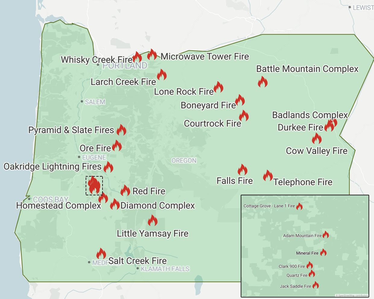
The Cascades and Southern Oregon Forests
The extensive forests of the Cascade Mountains and the southern part of the state are also significant wildfire zones.
- Willamette National Forest and Mount Hood National Forest: These forests, popular for hiking, camping, and winter sports, contain vast areas of dense coniferous forests. While generally wetter than eastern Oregon, prolonged drought can lead to extreme fire danger. Areas around Crater Lake National Park (though a separate entity, its surrounding forests are part of this ecosystem) and popular trails like the Timberline Trail can be impacted.
- Rogue River-Siskiyou National Forest: Located in southwestern Oregon, this region is known for its diverse ecosystems, including dry forests at lower elevations and wetter forests higher up. It has experienced some of the state’s most destructive wildfires in recent years. Areas near Grants Pass and along the Illinois River have been particularly vulnerable.
- Urban-Wildland Interface: Many communities in the foothills of the Cascades and in southern Oregon are situated at the urban-wildland interface, where human development meets flammable wildlands. This proximity increases the risk of fires impacting populated areas.
Southern Oregon’s Chaparral and Grasslands
Southern Oregon also features drier shrublands and grasslands that can burn intensely.
- Klamath Basin: Areas around the Klamath Basin can experience significant fire activity, especially in years with low snowpack and hot summers.
- Medford and Ashland Areas: The foothills surrounding cities like Medford and Ashland often feature chaparral and dry grasses, creating a high risk for fires, particularly when combined with strong winds from the south or southwest.
Staying Informed and Planning Your Trip Safely
For travelers, proactive information gathering is key to enjoying Oregon’s natural attractions safely. Wildfire conditions can change rapidly, and it’s essential to have up-to-date information before and during your trip.
Resources for Real-Time Information
Several official sources provide critical wildfire information:
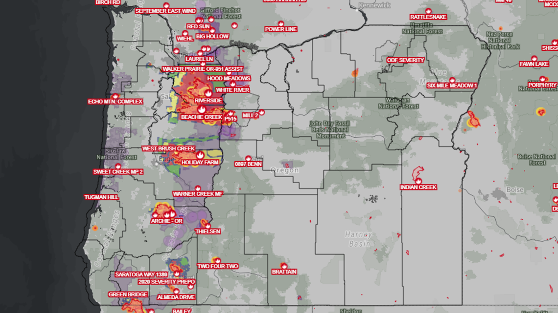
- Oregon Department of Forestry (ODF): The ODF is the primary agency responsible for wildfire suppression and prevention in much of the state. Their website and social media channels provide daily updates, fire maps, and burn ban information. They also issue fire restriction orders that can affect recreational activities.
- InciWeb: This is an interagency all-risk incident information management system that provides centralized information about large wildfires across the United States. For Oregon, InciWeb is an invaluable resource for detailed incident updates, maps, and evacuation information.
- National Weather Service (NWS): The NWS issues fire weather watches and red flag warnings, which indicate critical fire weather conditions. Paying attention to these warnings is crucial, as they signal an increased risk of extreme fire behavior.
- Local Fire Departments and Sheriff’s Offices: For specific local information, especially regarding evacuations or road closures, checking the websites and social media of local emergency services is highly recommended.
Essential Travel Tips for Wildfire Season
When traveling in Oregon during wildfire season (typically late spring through fall), consider the following:
- Check Conditions Before You Go: Always consult the ODF and InciWeb for current wildfire activity and fire restrictions in the areas you plan to visit. This includes checking for any campfire bans or closures of recreational areas.
- Know Your Escape Routes: If you are staying in or traveling through areas with known wildfire risk, familiarize yourself with multiple escape routes.
- Practice Fire Safety: If you are camping or engaging in activities that involve open flames, strictly adhere to all fire regulations. Ensure campfires are completely extinguished. Dispose of cigarettes properly.
- Be Prepared for Disruptions: Wildfires can lead to sudden road closures, evacuations, and air quality advisories. Have backup plans and be prepared to alter your itinerary if necessary.
- Monitor Air Quality: Wildfires can significantly impact air quality, even hundreds of miles away. Check the Oregon Department of Environmental Quality (DEQ) for daily air quality reports and advisories. If air quality is poor, limit outdoor activities, especially strenuous ones.
- Respect Closures and Restrictions: If an area is closed due to wildfire activity or restrictions are in place, respect these measures. They are for your safety and the safety of emergency responders.
Protecting Oregon’s Natural Treasures
Oregon’s wildlands are a national treasure, offering visitors a profound connection with nature. By understanding the wildfire landscape, staying informed through reliable sources, and practicing responsible behavior, travelers can help protect these precious resources while enjoying the unparalleled beauty that Oregon has to offer. Whether you’re exploring the majestic Columbia River Gorge, the serene lakes of the Crater Lake region, or the rugged eastern wilderness, a little preparation goes a long way in ensuring a safe and memorable experience.
LifeOutOfTheBox is a participant in the Amazon Services LLC Associates Program, an affiliate advertising program designed to provide a means for sites to earn advertising fees by advertising and linking to Amazon.com. Amazon, the Amazon logo, AmazonSupply, and the AmazonSupply logo are trademarks of Amazon.com, Inc. or its affiliates. As an Amazon Associate we earn affiliate commissions from qualifying purchases.