
The California Gold Rush, a pivotal moment in American history, ignited an unprecedented surge of migration and transformed the landscape of California. While often generalized as a statewide phenomenon, the true epicenter of this monumental event was concentrated in specific regions, primarily the Sierra Nevada Foothills. Understanding “where” this happened requires delving into the precise locations that bore witness to the initial discovery, the subsequent explosion of mining activities, and the establishment of the boomtowns that defined the era. These sites, many preserved as significant landmarks today, offer tangible links to the intrepid prospectors and the profound changes wrought by the pursuit of gold.

The Genesis: Sutter’s Mill and Coloma
The starting gun for the California Gold Rush was fired on January 24, 1848, with a seemingly innocuous discovery at a sawmill near the American River. This event marked the precise geographical genesis of a global phenomenon.
James W. Marshall‘s Discovery
The story begins at a sawmill being constructed by James W. Marshall for John Sutter, an entrepreneur who had established a vast agricultural empire near present-day Sacramento. While overseeing the construction of the millrace – a channel designed to divert water to power the mill – Marshall spotted shining flecks in the tailrace. These weren’t just ordinary rocks; they were flakes of gold. The location of this momentous finding was on the south fork of the American River, specifically near what is now known as Coloma.
Today, this site is meticulously preserved as the Marshall Gold Discovery State Historic Park. Visitors to the park in Coloma can stand precisely where Marshall made his discovery, viewing a replica of Sutter’s Mill and exploring the historical buildings of the burgeoning settlement that grew up around it. The park serves as a foundational landmark, illustrating the very beginning of the rush and the early, primitive methods of gold extraction like panning and sluicing. Its existence highlights the geographical point of origin and the immediate impact on the immediate surroundings, which rapidly transformed from a quiet milling operation into a bustling hub of prospectors.
The Birth of a Boomtown
News of Marshall’s discovery spread, initially slowly, then like wildfire. Within months, the area around Sutter’s Mill and Coloma was swarmed with eager fortune-seekers. This initial concentration of activity near the discovery site rapidly expanded, creating a cluster of temporary settlements and fueling the push into adjacent gold-rich territories. Coloma itself became one of the earliest and most significant mining towns, a testament to the direct impact of the initial discovery on specific localities. Its transformation from a quiet valley to a roaring boomtown encapsulates the rapid geographical spread of the Gold Rush.
The Mother Lode: A Vein of Riches
While Coloma was the spark, the true engine of the Gold Rush was a vast geological formation known as the Mother Lode. This was the primary geographical area where the majority of gold was found and extracted.
Geographical Extent: Sierra Nevada Foothills
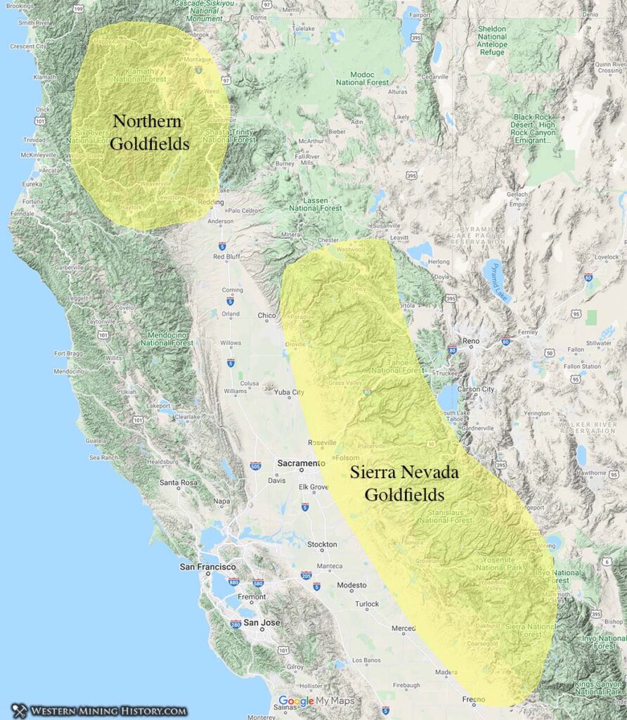
The Mother Lode is not a single mine but a rich, roughly 120-mile-long belt of gold-bearing quartz veins and associated placer deposits running northwest-southeast through the Sierra Nevada Foothills. It stretches from Mariposa in the south to Downieville in the north, primarily encompassing portions of Amador, Calaveras, El Dorado, Mariposa, Nevada, Placer, Tuolumne, and Yuba counties. This region became the heartland of the Gold Rush, where prospectors fanned out, establishing countless mining camps along rivers, creeks, and hillsides. The geology of the Sierra Nevada Foothills, characterized by ancient riverbeds and fractured rock containing gold, dictated the precise locations where mining operations flourished.
Key Gold Rush Towns and Mining Districts
Along this extensive Mother Lode belt, numerous towns sprang up, each a testament to the furious pace of development and the transient nature of the gold economy. These locations today stand as significant landmarks, some preserved, others in ruins, but all echoing the past.
- Northern Mines: North of Coloma, towns like Auburn, Grass Valley, and Nevada City became prominent. Nevada City, for instance, was renowned for its hydraulic mining operations, leaving dramatic landscape alterations as a lasting landmark. Grass Valley boasted some of the deepest and most productive hard-rock gold mines, such as the Empire Mine, now preserved as the Empire Mine State Historic Park.
- Central Mines: This area included famous locales such as Placerville (originally “Hangtown”), Sutter Creek, Jackson, and Sonora. These towns often developed more permanent structures and infrastructures, reflecting a longer-term commitment to the region’s mineral wealth. Columbia State Historic Park, south of Sonora, stands as a prime example, a remarkably preserved town offering a vivid glimpse into a 1850s gold-mining community.
- Southern Mines: Further south, towns like Angels Camp and Mariposa marked the southern extent of the Mother Lode. Mariposa, in particular, was the site of the Mariposa Grant, a large landholding of John C. Frémont that eventually became a major mining area itself.
These towns, whether vibrant communities or ghost towns, are crucial landmarks that geographically define the primary region of the California Gold Rush. They are not merely historical footnotes but physical locations that continue to tell the story through their architecture, ruins, and preserved streetscapes.
Beyond the Gold Fields: San Francisco as the Gateway

While the gold itself was found in the foothills, the economic and logistical hub that facilitated the entire rush was located at the western edge of California: San Francisco Bay.
Port of Entry and Supply Hub
San Francisco was not a gold-mining town, but it was arguably the most crucial urban landmark of the California Gold Rush. Its natural deep-water harbor made it the primary port of entry for hundreds of thousands of immigrants arriving by sea from around the globe. Ships arrived laden with hopeful prospectors and essential supplies – tools, provisions, clothing, and luxuries – all destined for the goldfields. The city’s waterfront became a chaotic, bustling scene, with hundreds of abandoned ships lining the bay as their crews deserted to seek their fortunes inland.
This geographical role as a supply and transit point led to explosive growth. What was once a small village known as Yerba Buena before the gold discovery, transformed almost overnight into a teeming metropolis. Its docks, warehouses, and commercial streets became indelible landmarks of the Gold Rush’s broader logistical framework, connecting the isolated mining camps to the global economy.
Transformation into a Metropolis
The influx of people and capital transformed San Francisco into the economic heart of California. Banks, assay offices, supply houses, and entertainment establishments proliferated. The city’s rapid development, characterized by swift construction and frequent devastating fires followed by even swifter rebuilding, solidified its status as a major urban center. While no gold was mined directly in San Francisco, its historical landmarks, from its preserved waterfront districts to its historic financial institutions, directly reflect its indispensable role in the Gold Rush. It was the place where fortunes were consolidated, where equipment was procured, and where the outside world connected with the remote goldfields.
Enduring Legacies: Preserving Gold Rush Landmarks
The “where” of the California Gold Rush is not just a historical map; it’s a living landscape of preserved landmarks and historical sites that allow us to step back in time.
State Historic Parks and Museums
Numerous locations have been designated as state historic parks, ensuring their preservation and accessibility for future generations. Marshall Gold Discovery State Historic Park in Coloma is the foremost example, marking the birthplace of the rush. Columbia State Historic Park, near Sonora, is another remarkable landmark, a genuine gold rush town preserved as a living museum where visitors can experience 19th-century life. Further north, the Empire Mine State Historic Park in Grass Valley showcases the deep quartz mining operations, a stark contrast to the initial panning in riverbeds. These parks offer educational experiences and protect the physical remnants of the past. Many towns along the Gold Rush Trail also feature local museums, like the Placerville Historical Museum or the Nevada County Historical Society, which house artifacts and stories specific to their locales.
Ghost Towns and Living History Sites
Beyond the formally preserved parks, the Mother Lode region is dotted with a multitude of ghost towns and semi-preserved sites. These vary from well-maintained landmarks like Bodie State Historic Park – an incredibly well-preserved ghost town frozen in time – to less accessible ruins of former mining camps. Each site, whether a fully restored main street or a collection of crumbling foundations, marks a specific geographical point where the drama of the Gold Rush unfolded. These landmarks allow visitors to grasp the sheer scale of the population movement and the ephemeral nature of many of these settlements. The remnants of hydraulic mining operations, such as the vast gravel pits and erosion scars, also serve as unique, if sometimes controversial, geological landmarks of the era’s environmental impact.
The Geographical Footprint: A Modern Perspective
Today, the “where” of the California Gold Rush can be traced through a distinct geographical itinerary, often referred to as the Gold Rush Trail.
Driving the Gold Rush Trail (Highway 49)
The most direct way to experience the geographical scope of the California Gold Rush is to drive along California State Route 49, commonly known as the Gold Rush Trail or Highway 49. This scenic highway snakes through the heart of the Mother Lode, connecting many of the historic mining towns from Oakhurst in the south to Vinton in the north. A journey along Highway 49 is a journey through time, passing through towns like Mariposa, Sonora, Columbia, Placerville, Auburn, Grass Valley, and Nevada City. Each stop along this route offers unique landmarks – historic buildings, mining relics, informative plaques, and museums – that collectively paint a comprehensive picture of the geographical extent and varied experiences of the Gold Rush.
Experiencing the History Today
The legacy of the Gold Rush is etched into the very landscape of these Sierra Nevada Foothills. The deep cuts of former placer mines, the restored facades of 19th-century saloons and general stores, and the intricate machinery of hard-rock mines all serve as monumental landmarks. From the initial discovery site at Sutter’s Mill to the bustling port of San Francisco and the countless mining camps in between, the California Gold Rush happened in a specific and identifiable geographical region. These landmarks are not just points on a map but portals to understanding one of the most transformative periods in California and American history.
LifeOutOfTheBox is a participant in the Amazon Services LLC Associates Program, an affiliate advertising program designed to provide a means for sites to earn advertising fees by advertising and linking to Amazon.com. Amazon, the Amazon logo, AmazonSupply, and the AmazonSupply logo are trademarks of Amazon.com, Inc. or its affiliates. As an Amazon Associate we earn affiliate commissions from qualifying purchases.