
The Colorado River, a lifeblood of the arid American West, is a natural wonder whose story begins far from the desert canyons and vibrant cities it sustains. Its origins are a testament to geological forces, alpine grandeur, and a delicate balance that has shaped landscapes and civilizations for millennia. To truly understand the significance of this mighty river, one must trace its journey back to its pristine source, a place where snowmelt and mountain streams converge to begin a thousands-of-miles-long odyssey.
The Crown of the Continent: Rocky Mountain National Park
The genesis of the Colorado River lies within the breathtaking expanse of Rocky Mountain National Park in north-central Colorado. This protected wilderness, a jewel of the United States, is characterized by its dramatic peaks, alpine lakes, and diverse ecosystems. It is here, amidst the towering heights of the Continental Divide, that the river’s first trickles are born.

Snowmelt and Alpine Springs: The Birthplace
The primary source of the Colorado River is the abundant snowpack that accumulates at high elevations within the park. During the spring and early summer, this snow begins to melt, feeding a network of small streams and springs. These nascent waterways, often crystal clear and icy cold, gather momentum as they cascade down the mountain slopes.
One of the most significant headwaters is the meandering stream that emerges from the western slopes of Moffat Road near the Milner Pass. This area is part of the park’s alpine tundra, a harsh yet beautiful environment above the treeline. Here, the water is pure, reflecting the vast blue sky and the surrounding snow-capped mountains. The initial flow is modest, a gentle whisper of what will become a powerful force.
Another crucial contributor is the area around the Never Summer Mountains, to the west of the main park. Glacial melt and numerous high-altitude springs in this rugged terrain also feed the growing river. The confluence of these various ephemeral streams and permanent springs marks the true beginning of the Colorado River.
The Continental Divide: A Watery Barrier
A defining geographical feature at the origin of the Colorado River is the Continental Divide. This imaginary line, which runs along the crest of the Rocky Mountains, separates the watersheds that drain into the Atlantic Ocean from those that drain into the Pacific Ocean. The waters originating on the western side of the Continental Divide within Rocky Mountain National Park flow towards the Pacific, eventually forming the mighty Colorado River.
This geological separation is fundamental to understanding the river’s course. Water that falls on the eastern side of the divide will travel thousands of miles in the opposite direction, eventually reaching the Gulf of Mexico via rivers like the Missouri River and the Mississippi River. The pristine headwaters of the Colorado River are thus geographically destined for a westward journey.
From Mountain Streams to Mighty Flow: The Upper Basin
As the nascent Colorado River begins its descent from the high peaks, it gains strength and volume. The initial collection of rivulets merges into larger streams, carving their way through the alpine meadows and dense forests of the park. The landscape here is dynamic, characterized by steep gradients, rocky outcrops, and the occasional cascading waterfall.
Tributaries of the Upper Colorado
Several small but significant tributaries contribute to the river’s growth within its upper reaches. These include alpine creeks that carry meltwater from surrounding glaciers and snowfields, as well as subsurface springs that emerge from underground aquifers. The purity of these waters is remarkable, untainted by human activity, a characteristic that defines the river’s early journey.
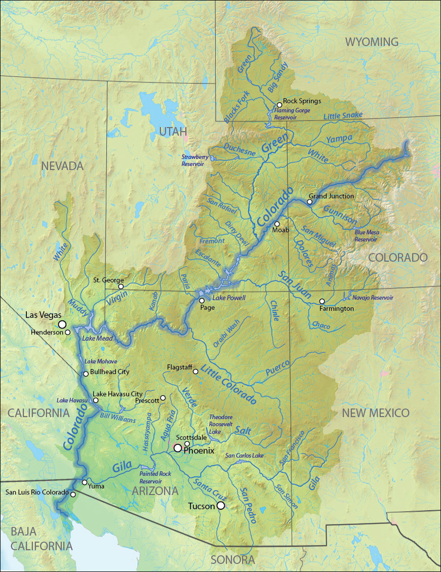
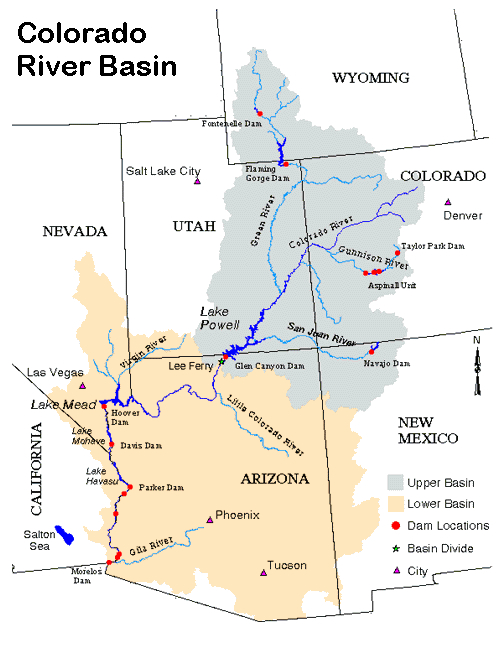
The region just outside the park boundaries, often referred to as the Upper Basin, sees the river solidify its form. It moves through valleys and canyons, its path increasingly defined by the surrounding geology. While not yet the vast river known to many, its power is evident in its relentless flow and the erosive force it exerts on the landscape.
The Role of Geology and Climate
The geology of the Rocky Mountains plays a critical role in shaping the river’s origin. The uplift of these ancient mountain ranges created the high elevations necessary for significant snow accumulation. The types of rock present, from granite to sedimentary layers, influence the drainage patterns and the chemical composition of the water as it picks up minerals from its journey.
The climate, characterized by cold, snowy winters and relatively dry summers, is also paramount. The annual snowpack acts as a natural reservoir, storing vast quantities of water that are released gradually throughout the warmer months. This consistent, albeit seasonal, water supply is what allows the Colorado River to maintain a significant flow even in the arid regions it will later traverse.
Beyond the Peaks: The Journey South and West
Once the Colorado River leaves the immediate vicinity of Rocky Mountain National Park, its character begins to transform. It flows south and then west, gathering more tributaries and increasing in width and depth. The landscape transitions from dense conifer forests to more open montane environments.
Grand County and Middle Park
The river’s path takes it through Grand County, a region that includes parts of the expansive Middle Park basin. Here, the river widens, and its flow becomes more predictable, though still subject to seasonal variations. The terrain begins to flatten somewhat before the river carves its way through more rugged canyonlands.
Confluence with the Gunnison River
A significant milestone in the river’s journey towards its more famous stretches is its confluence with the Gunnison River. The Gunnison River is itself a major waterway, originating in the San Juan Mountains. Its considerable volume adds substantially to the Colorado River, marking a transition from a regional river to a river of interstate importance. This confluence occurs in the western part of Colorado, a region increasingly characterized by its dramatic mesas and deep canyons.
The Legacy of the Headwaters
The origins of the Colorado River in the high Rocky Mountains are a critical element in understanding its entire ecosystem and the challenges it faces. The pristine nature of its source waters directly impacts the quality of the water that flows downstream, supporting diverse flora and fauna and sustaining millions of people.
An Indicator of Environmental Health
The headwaters of the Colorado River serve as an important indicator of the environmental health of the region. Changes in snowpack, temperature, and precipitation patterns due to climate change can have profound effects on the river’s flow. Monitoring and protecting these high-altitude sources are therefore essential for the long-term sustainability of the entire river basin.
The Importance of Conservation
The delicate ecosystem of Rocky Mountain National Park and the surrounding headwaters require vigilant conservation efforts. Protecting these areas from pollution, habitat degradation, and the impacts of increasing human activity ensures that the Colorado River will continue to flow, a vital artery through the American West, for generations to come. The journey of this iconic river, from a humble trickle in the high Rockies to a force that shapes landscapes and economies, is a powerful narrative of nature’s grandeur and resilience.
LifeOutOfTheBox is a participant in the Amazon Services LLC Associates Program, an affiliate advertising program designed to provide a means for sites to earn advertising fees by advertising and linking to Amazon.com. Amazon, the Amazon logo, AmazonSupply, and the AmazonSupply logo are trademarks of Amazon.com, Inc. or its affiliates. As an Amazon Associate we earn affiliate commissions from qualifying purchases.