
Arizona, a name synonymous with vast deserts, iconic red rock formations, and unparalleled natural beauty, is a state that firmly anchors the southwestern corner of the United States. Its geographical placement is not merely a point on a map; it is fundamental to understanding its diverse landscapes, unique climate, and its immense appeal as a premier travel destination. For anyone planning an adventure in this captivating region, the first step is always to pinpoint exactly “Where is Arizona on the United States map?”
This state occupies a distinctive position, bordered by several other states and an international boundary, defining its character and offering a gateway to a myriad of travel experiences. From its scorching desert lowlands to its snow-capped peaks, Arizona’s location dictates everything from its weather patterns to the accessibility of its world-famous attractions. Understanding its precise spot on the national canvas is crucial for appreciating its strategic importance within the American Southwest and for navigating its breathtaking terrain effectively.
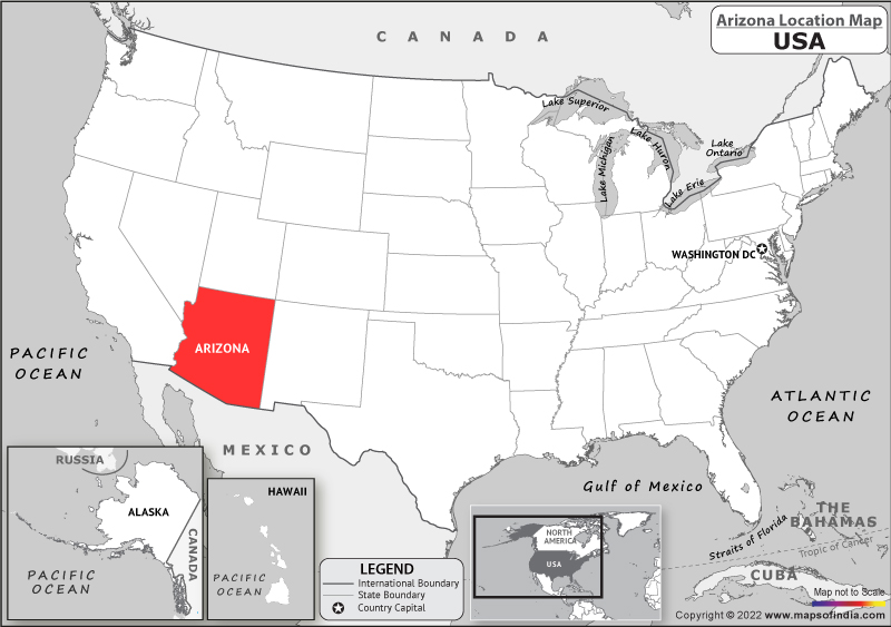
Pinpointing Arizona: A Southwestern Jewel
Arizona’s geographical location is as striking as its scenery, firmly placing it in the heart of the American Southwest. This positioning contributes significantly to its unique identity, serving as a crossroads of cultures, climates, and geological wonders.
Geographical Coordinates and Borders
Arizona is situated approximately between 31° and 37° North latitude and 109° and 115° West longitude. This range places it firmly in the lower latitudes of the United States, contributing to its famously warm and sunny climate.
The state shares extensive borders with several other states, making it a pivotal part of any regional road trip itinerary. To its west lies California and Nevada, offering seamless transitions between desert landscapes and metropolitan hubs. To the north, Arizona borders Utah, leading directly into the dramatic canyonlands of that state. The northeastern corner of Arizona is particularly notable as it is part of the Four Corners region, where Arizona, Utah, Colorado, and New Mexico meet at a single point—the only place in the United States where four states converge. To its east, Arizona shares a border with New Mexico, another state rich in Native American history and stunning desert vistas.
Perhaps one of its most defining geographical features is its long southern border with Mexico, specifically the states of Sonora and Baja California. This international boundary has profoundly influenced Arizona’s culture, demographics, and economy, creating a vibrant blend of American and Mexican heritage that is evident in its cuisine, architecture, and traditions.
Key Cities and Their Locations
Understanding the placement of Arizona’s major cities helps travelers orient themselves within the state and plan their routes effectively.
- Phoenix: As the state capital and largest city, Phoenix is centrally located in the south-central part of the state, nestled within the vast Sonoran Desert. It serves as the primary gateway to Arizona, home to Phoenix Sky Harbor International Airport (PHX), a major hub for domestic and international flights. Its central position makes it an ideal starting point for exploring both northern and southern Arizona.
- Tucson: Situated about 100 miles south of Phoenix and approximately 60 miles north of the Mexican border, Tucson is Arizona’s second-largest city. Its southern location provides a distinct cultural flavor, heavily influenced by its proximity to Mexico, and is the gateway to the unique desert landscapes of Saguaro National Park.
- Flagstaff: In stark contrast to the desert cities, Flagstaff is located in northern Arizona, at an elevation of nearly 7,000 feet, surrounded by the world’s largest contiguous ponderosa pine forest. This mountain city serves as the primary gateway to the Grand Canyon National Park and offers a much cooler climate, even experiencing significant snowfall in winter, making it a popular destination for skiing and other cold-weather activities.
- Sedona: Famous for its stunning red rock formations and vibrant arts scene, Sedona lies approximately 30 miles south of Flagstaff in a transitional zone between the desert and the high country. Its accessible location, just a two-hour drive north of Phoenix, makes it a popular day trip or weekend escape.
- Yuma: Located in the southwest corner of the state, near the California border and close to Mexico, Yuma is known for its extreme desert climate and historical significance along the Colorado River. It’s a popular winter destination for “snowbirds” seeking warm temperatures.
Arizona’s Diverse Landscapes: A Traveler’s Dream
Arizona’s geographical position is the primary architect of its astounding landscape diversity, transforming it into a traveler’s paradise where distinct ecological zones coexist within relatively short distances.
From Desert to Mountains
The state’s location ensures a dramatic shift in elevation and climate, leading to an incredible range of natural environments.
- Southern Arizona is largely dominated by the Sonoran Desert, characterized by iconic saguaro cacti, vast expanses of scrubland, and intense summer heat. This is where cities like Phoenix and Tucson thrive, offering unique desert-adapted flora and fauna. Travel experiences here revolve around hiking at dawn or dusk, exploring desert botanical gardens, and enjoying the mild winters.
- Moving northward, the elevation gradually rises, leading to a dramatic transition zone known as the Mogollon Rim. This steep escarpment marks the southern edge of the Colorado Plateau, a vast highland region. Above the Rim, Northern Arizona boasts vast forests of ponderosa pine, cooler temperatures, and even snow-capped mountains, including the San Francisco Peaks, home to Arizona’s highest point, Humphreys Peak. This allows for diverse activities like skiing in winter (at Arizona Snowbowl near Flagstaff), mountain biking, and escaping the summer heat of the lowlands.
This distinct climatic and topographical variation means travelers can experience blistering desert heat, temperate forest air, and even alpine chill, all within a few hours’ drive.
Iconic Natural Wonders and Their Locations
Arizona’s position on the map is directly responsible for housing some of the most recognized natural wonders in the United States and the world.
- Grand Canyon National Park: Arguably the state’s most famous landmark, the Grand Canyon is carved by the Colorado River through the Colorado Plateau in northern Arizona. Its vast scale and intricate geological formations draw millions of visitors annually, primarily to the accessible South Rim, approximately a 3.5-hour drive north of Phoenix.
- Monument Valley: Located in the extreme northeastern corner of the state, primarily on Navajo Nation land and bordering Utah, this iconic landscape of towering sandstone buttes and mesas is a symbol of the American West and a popular filming location.
- Saguaro National Park: Split into two districts just east and west of Tucson, this park protects the nation’s largest cacti, the majestic saguaro. Its proximity to Tucson makes it an easily accessible desert experience.
- Petrified Forest National Park: Found in eastern Arizona, this park is renowned for its vast deposits of petrified wood and its unique painted desert landscapes. It’s located along Historic Route 66, making it a popular stop for road trippers.
- Antelope Canyon and Horseshoe Bend: Both are located near the city of Page in northern Arizona, close to the Utah border. Antelope Canyon, a stunning slot canyon, is a testament to erosion’s artistry, while Horseshoe Bend offers a dramatic view of the Colorado River creating a perfect meander.
- Lake Powell: A vast reservoir on the Colorado River, Lake Powell straddles the Arizona-Utah border, offering incredible opportunities for boating, fishing, and exploring its countless coves and canyons.

Strategic Location for Regional Exploration
Arizona’s geographical placement within the Southwest United States positions it as an ideal starting point or central hub for broader regional exploration, a significant advantage for any traveler.
Gateway to the American Southwest
Due to its central location and extensive borders with five other states, Arizona is often considered the heart of the American Southwest. This makes it an excellent base for multi-state road trips, allowing travelers to easily access renowned national parks and attractions in neighboring regions. For example:
- From northern Arizona, travelers can seamlessly connect to Zion National Park and Bryce Canyon National Park in southern Utah.
- Western Arizona provides convenient access to Las Vegas, Nevada, and Death Valley National Park in California.
- Its border with New Mexico opens up avenues to explore Santa Fe, Taos, and the rich cultural heritage of the Land of Enchantment.
This interconnectedness makes Arizona a dynamic travel destination, not just for what it offers within its borders, but also for its role as a launching pad for wider adventures across the scenic and culturally rich Southwest.
Connectivity and Accessibility
Arizona’s strategic location is complemented by excellent infrastructure, making it highly accessible for travelers from across the globe.
- Major Airports: Phoenix Sky Harbor International Airport (PHX) is one of the busiest airports in the United States, offering direct flights to numerous domestic and international destinations. Tucson International Airport (TUS) provides another significant entry point in the southern part of the state. Smaller regional airports, like those in Flagstaff and Page, facilitate access to specific northern attractions.
- Interstate Highways: The state is crisscrossed by major interstate highways. I-10 runs east-west through Phoenix and Tucson, connecting California to New Mexico. I-17 extends north from Phoenix to Flagstaff, serving as the main artery to northern Arizona’s wonders. I-40 traverses the northern part of the state, connecting California to New Mexico and passing near the Grand Canyon.
This robust network of transportation hubs and roadways means that knowing Arizona’s location is the first step in planning efficient flights, calculating driving distances, and crafting an itinerary that maximizes exploration of its diverse regions.
Planning Your Arizona Adventure: Location-Based Insights
Armed with an understanding of where Arizona sits on the map, travelers can make informed decisions to optimize their travel plans, ensuring a seamless and enjoyable experience tailored to their interests.
Seasonal Considerations and Best Times to Visit
Arizona’s diverse geography leads to varied climatic zones, making location a critical factor in determining the best time to visit different parts of the state.
- Southern Arizona (Desert Regions): For cities like Phoenix, Tucson, and Yuma, the ideal travel season spans from fall (October) through spring (April). During these months, temperatures are pleasant and mild, perfect for outdoor activities like hiking, golfing, and exploring desert botanical gardens. Summers (June-September) in the desert can be extremely hot, with temperatures often exceeding 100°F (38°C), making outdoor activities challenging, though many resorts offer excellent indoor and pool-based escapes.
- Northern Arizona (High Country): Destinations like Flagstaff, the Grand Canyon, and Sedona offer a completely different climate. Summers here are delightfully warm and serve as a popular escape from the southern desert heat, ideal for hiking, camping, and sightseeing. Winters bring snow, transforming the landscape into a winter wonderland and allowing for skiing and snowboarding near Flagstaff. Spring and fall offer crisp air and stunning foliage.
Understanding this geographical temperature divide allows travelers to align their visit with the activities they desire, whether it’s basking in the winter sun or hiking among cool pine forests.
Navigating Distances and Travel Times
Arizona is a vast state, and knowing its dimensions is crucial for travel planning. While attractions might appear relatively close on a small map, actual driving distances and times can be substantial.
- For instance, driving from Phoenix to the South Rim of the Grand Canyon typically takes 3.5 to 4 hours, without stops.
- A journey from Tucson to Page (for Antelope Canyon and Horseshoe Bend) can easily be a 6-7 hour drive.
- Even within a single region, like the drive from Flagstaff to Monument Valley, takes approximately 3 hours.
Travelers should budget ample time for transit between destinations and consider overnight stays to avoid rushing and fully appreciate each area. Mapping out routes in advance, utilizing GPS, and accounting for potential delays (especially during peak season or due to weather) are essential for a smooth Arizona road trip.
Maximizing Your Travel Experience
Leveraging Arizona’s diverse geographical features and strategic location can significantly enhance your travel experience:
- Combine Climates and Landscapes: Plan an itinerary that blends the warmth of the Sonoran Desert with the cooler high country. For example, start with a few days in Phoenix or Tucson, then drive north to Sedona, Flagstaff, and the Grand Canyon. This offers a full spectrum of Arizona’s beauty.
- Multi-State Road Trips: Take advantage of Arizona’s position as a gateway to the Southwest. Consider extending your trip to include national parks in Utah, Nevada, or New Mexico, creating an unforgettable regional adventure.
- Embrace the Journey: The drives between attractions in Arizona are often as scenic as the destinations themselves. Utilize mapping tools to identify scenic routes, pull-offs, and small towns that offer unique local experiences.
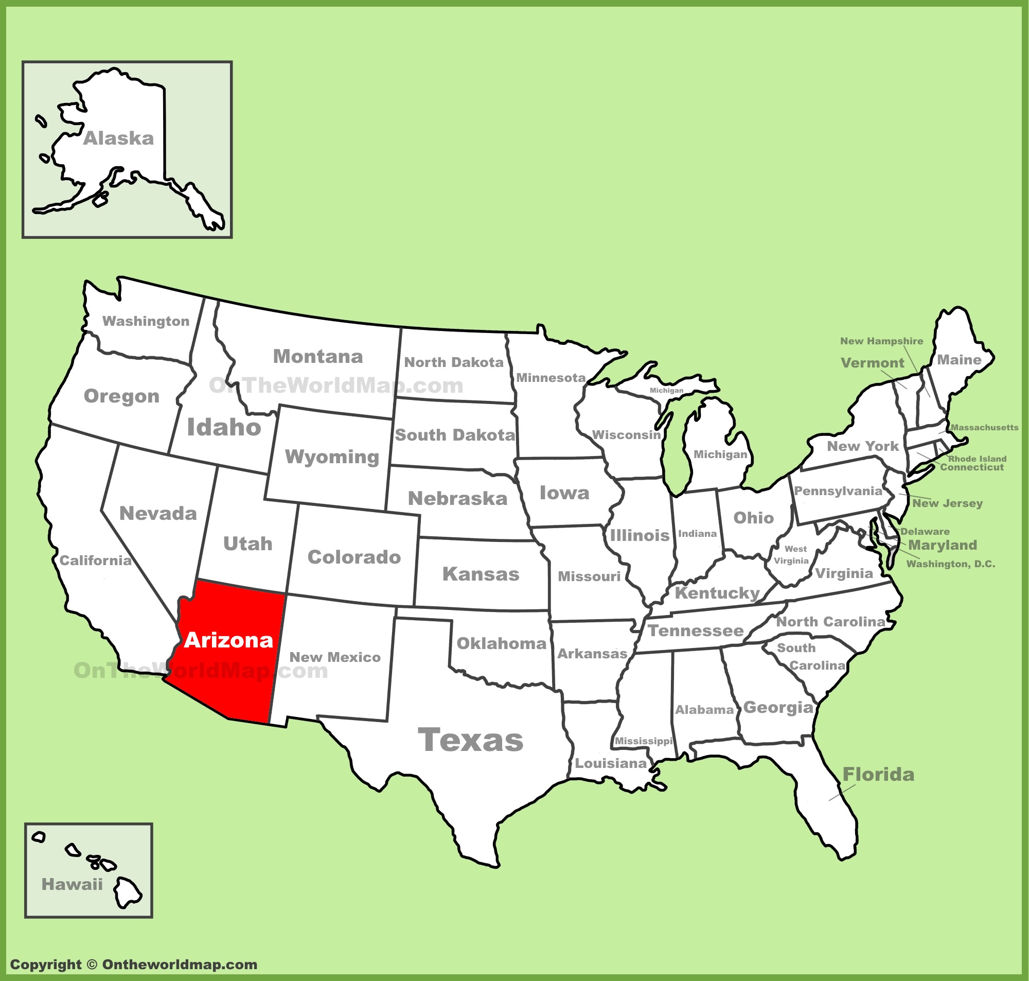
Arizona’s Indelible Mark on the Map
Understanding where Arizona is on the United States map is more than a simple geography lesson; it’s the foundational knowledge for unlocking the full potential of this remarkable state as a travel destination. Its position in the American Southwest, bordered by a tapestry of states and an international neighbor, underpins its extraordinary geological and climatic diversity. From the iconic Grand Canyon to the lush Sonoran Desert, every unique landscape and vibrant city is intrinsically linked to its geographical coordinates.
For travelers, this geographical insight translates into smarter planning, better itinerary choices, and a deeper appreciation for the journey. Arizona’s indelible mark on the map isn’t just a place; it’s an invitation to explore a world where ancient cultures meet modern adventure, all shaped by its spectacular and diverse location. So, when you look at the map, remember that Arizona is not just a point, but a sprawling, dynamic land waiting to be discovered.
LifeOutOfTheBox is a participant in the Amazon Services LLC Associates Program, an affiliate advertising program designed to provide a means for sites to earn advertising fees by advertising and linking to Amazon.com. Amazon, the Amazon logo, AmazonSupply, and the AmazonSupply logo are trademarks of Amazon.com, Inc. or its affiliates. As an Amazon Associate we earn affiliate commissions from qualifying purchases.