
For many travelers mapping out their next adventure in the Golden State, the question “Where is Fresno, California on a map?” is a crucial starting point. Often dubbed the “Heart of California’s Central Valley,” Fresno isn’t just a dot on the map; it’s a strategically positioned hub that serves as a vibrant destination in its own right and an unparalleled gateway to some of the nation’s most breathtaking natural wonders. Understanding its geographical placement is key to unlocking the diverse travel experiences it offers, from agricultural heritage and burgeoning urban culture to unparalleled access to iconic national parks.

This article delves into Fresno’s precise location, exploring how its position shapes its identity as a travel destination, connecting visitors to a rich tapestry of adventures that span from verdant farmlands to towering mountain peaks. Whether you’re planning a road trip, seeking outdoor exploration, or curious about the agricultural backbone of California, pinpointing Fresno’s spot on the map is the first step toward an unforgettable journey.
Pinpointing Fresno: A Central Valley Gem
To truly appreciate Fresno as a travel destination, one must first grasp its fundamental geographical context. Situated almost perfectly in the center of California, Fresno is the fifth-largest city in the state, making it a significant urban center amidst a vast agricultural landscape. Its placement is not just a matter of latitude and longitude; it’s a defining feature that dictates its climate, its economy, and its appeal to travelers.
Geographical Coordinates and Context
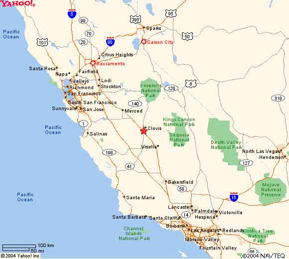
Fresno, California is located at approximately 36.7378° N latitude and 119.7871° W longitude. This places it squarely within the heart of the fertile San Joaquin Valley, a region renowned globally for its agricultural output. The city sits on a vast, flat plain, a characteristic that defines much of the Central Valley. This seemingly simple fact has profound implications for its travel identity. The consistent sunshine, warm temperatures, and nutrient-rich soil have cultivated an environment where a diverse array of crops thrive, creating a unique landscape of orchards, vineyards, and farmlands that are both economically vital and visually captivating. For travelers, this means opportunities for farm tours, fresh produce markets, and experiencing the essence of California’s agricultural heritage.
The San Joaquin Valley Advantage
Fresno’s location within the San Joaquin Valley is its greatest asset, transforming it from a mere waypoint into a destination with distinct advantages. This valley is often called the “food basket of the world,” producing over 250 different crops. This agricultural prowess isn’t just a backdrop; it’s an integral part of the travel experience. Visitors can witness the cyclical beauty of farming, from spring blossoms to autumn harvests. The flat terrain also allows for easy navigation, making it an accessible area for exploration by car or bicycle. Beyond agriculture, the valley floor provides a relatively mild winter climate compared to the nearby mountains, making it a year-round destination for various activities.
Proximity to Major California Cities
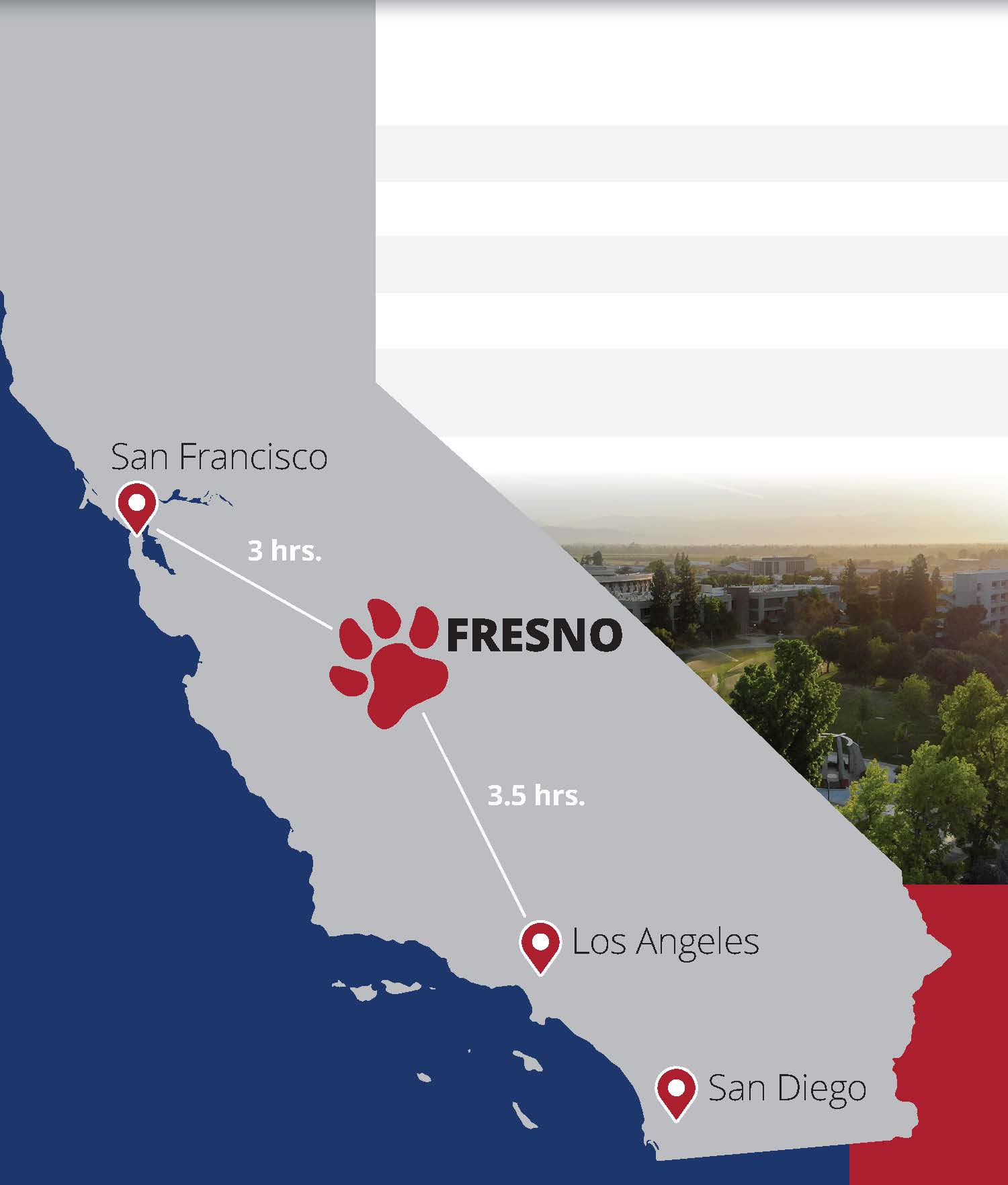
One of Fresno’s most compelling geographical benefits is its central location relative to California’s major metropolitan areas. It sits roughly equidistant from the state’s two largest population centers: approximately 220 miles (350 km) north of Los Angeles and about 185 miles (300 km) south of San Francisco. The state capital, Sacramento, is also within a reasonable driving distance, about 170 miles (270 km) to the north. This makes Fresno an ideal stopover for travelers traversing the length of California along Highway 99 or Interstate 5, offering a comfortable break from urban congestion and a change of scenery. Its central position also positions it perfectly for visitors looking to explore multiple facets of California without excessive travel times between regions.
Fresno as a Gateway to California’s Natural Wonders
While its Central Valley location is significant, Fresno’s true allure for many travelers lies in its unparalleled proximity to the Sierra Nevada mountain range. This geographical advantage transforms Fresno into the quintessential base camp for exploring some of America’s most iconic national parks and pristine wilderness areas. For those who seek adventure, stunning landscapes, and a deep connection with nature, Fresno’s map coordinates point directly to an outdoor enthusiast’s paradise.
The Majestic Sierra Nevada
Rising dramatically to Fresno’s east, the Sierra Nevada is a majestic mountain range that defines much of California’s eastern border. From the city, one can often see the snow-capped peaks in the distance, a constant reminder of the incredible natural playground just a short drive away. This proximity means that travelers don’t have to endure long, tedious drives to access hiking trails, climbing routes, skiing resorts, or serene alpine lakes. The Sierra Nevada offers a diverse range of elevations and ecosystems, from oak woodlands to subalpine forests and barren granite peaks, providing a fresh adventure for every season.
Yosemite National Park: A Prime Day Trip or Multi-Day Adventure
Perhaps the most famous jewel of the Sierra Nevada, Yosemite National Park, is incredibly accessible from Fresno. The South Entrance (Wawona Gate) to Yosemite is roughly an hour and a half drive northeast of Fresno via Highway 41. This makes Fresno an ideal starting point for either a day trip to witness the grandeur of Yosemite Valley, El Capitan, and Half Dome, or as a convenient overnight base for a multi-day exploration of the park’s vast wilderness. Travelers can enjoy the urban comforts of Fresno in the evening and be surrounded by the unparalleled natural beauty of Yosemite by morning.
Kings Canyon National Park and Sequoia National Park: Exploring Giant Trees and Deep Canyons
Even closer than Yosemite, Kings Canyon National Park and Sequoia National Park are situated directly east of Fresno, just about an hour’s drive away. These two contiguous parks are famed for their colossal giant sequoia trees, including the world’s largest by volume, General Sherman Tree. Travelers can wander through ancient groves, marvel at trees that have stood for thousands of years, and explore the dramatic U-shaped valley of Kings Canyon, which boasts some of the deepest canyons in North America. Fresno’s location makes it a perfect hub for experiencing these awe-inspiring natural wonders, offering a chance to witness the majesty of the giant sequoias and the rugged beauty of the Sierra Nevada foothills with minimal travel time.
Other Nearby Natural Attractions
Beyond the iconic national parks, Fresno’s map location grants access to a plethora of other natural attractions ideal for day trips. Bass Lake, nestled in the foothills of the Sierra Nevada, offers opportunities for boating, fishing, and swimming. Shaver Lake is another popular spot for water activities and camping, offering cooler temperatures and mountain air. Closer to the city, Millerton Lake State Recreation Area provides recreational boating, fishing, and hiking, particularly around the beautiful historic Friant Dam. These diverse options ensure that whether you’re seeking high-altitude adventure or serene lakeside relaxation, Fresno serves as an excellent starting point.
Exploring Fresno Itself: Urban Charms and Local Flavors
While Fresno’s reputation as a gateway to national parks is undeniable, its position on the map also places it as a destination with its own unique urban charms, cultural attractions, and a deep connection to its agricultural roots. Beyond the stunning natural landscapes, the city offers a vibrant local scene, inviting travelers to explore its history, art, culinary offerings, and community spirit. For those asking “Where is Fresno on a map?”, the answer also includes a dynamic city worth discovering.
Downtown Fresno Revitalization
Fresno’s downtown area has undergone significant revitalization, transforming into a vibrant cultural and entertainment hub. Fulton Street, once a pedestrian mall, has been re-opened to traffic, breathing new life into the historic district with renovated buildings, public art installations, and a growing number of local businesses, restaurants, and breweries. This area, alongside the eclectic Tower District, known for its historic architecture, lively nightlife, independent shops, and diverse eateries, showcases the city’s commitment to fostering a dynamic urban environment. Travelers can enjoy live music, theatrical performances, art walks, and a wide array of dining experiences, reflecting Fresno’s evolving identity.
Cultural Hotspots
Fresno boasts a surprising array of cultural institutions that cater to diverse interests. The Fresno Chaffee Zoo is a nationally recognized zoo, home to over 200 species and actively involved in conservation efforts, providing an engaging experience for families and wildlife enthusiasts. One of the city’s most unique attractions is the Forestiere Underground Gardens, a subterranean labyrinth of courtyards, grottos, and garden spaces hand-dug by a Sicilian immigrant over 40 years. This architectural marvel and historical landmark offers a fascinating glimpse into one man’s extraordinary vision. Art lovers can explore Arte Americas, the largest Latino cultural center in the San Joaquin Valley, or visit the Fresno Art Museum, which features modern and contemporary art, as well as pre-Columbian artifacts.
Agricultural Roots and Farm-to-Fork Experiences
Given its location in the “food basket of the world,” Fresno’s connection to agriculture is profound and offers unique travel experiences. The Fresno County Blossom Trail, particularly vibrant in late winter and early spring, guides visitors through miles of blossoming fruit and nut orchards, creating a stunning spectacle of pink and white. Throughout the year, numerous farmers’ markets, such as the Old Town Clovis Farmers Market and the Vineyard Farmers Market, provide opportunities to sample fresh, locally grown produce, artisanal goods, and gourmet foods directly from the source. Many local restaurants embrace the farm-to-fork philosophy, offering menus that highlight seasonal ingredients from nearby farms, allowing travelers to taste the true flavors of the San Joaquin Valley.
Educational and Sporting Venues
Fresno is also home to significant educational and sporting institutions. California State University, Fresno, or Fresno State, is a prominent public university whose campus contributes to the city’s vibrant atmosphere, hosting various cultural events, lectures, and sporting competitions. The Save Mart Center, located on the Fresno State campus, is a multi-purpose arena that hosts major concerts, sporting events, and family shows, attracting visitors from across the region. These venues provide entertainment and educational opportunities that further enrich Fresno’s appeal as a diverse travel destination.
Planning Your Trip to Fresno: Travel and Logistics
Understanding “Where is Fresno, California on a map?” is the first step, but planning your journey requires practical considerations regarding transportation, timing, and navigation. Fresno’s accessible location and well-developed infrastructure make it relatively easy to reach and explore, ensuring a smooth and enjoyable travel experience whether you’re arriving by air or land.
Getting There
Fresno’s central location in California makes it highly accessible.
- By Air: The city is served by Fresno Yosemite International Airport (FAT), which offers direct flights to several major U.S. cities, including Denver, Dallas/Fort Worth, Las Vegas, Phoenix, Portland, Salt Lake City, San Diego, San Francisco, and Seattle. Its name underscores its role as a key entry point for travelers heading to Yosemite National Park and the other Sierra Nevada parks.
- By Car: Driving is a popular option, as Fresno is situated directly on Highway 99, a major north-south artery through the Central Valley. Highway 41 provides direct access from the south and is the primary route to Yosemite National Park from Fresno. Interstate 5, another significant north-south highway, runs slightly to the west of Fresno, requiring a short detour to reach the city.
- By Train/Bus: Amtrak provides passenger rail service to Fresno via its San Joaquin route, connecting it to Oakland, Sacramento, and Bakersfield with bus connections to Los Angeles and other destinations. Various bus services also operate to and from Fresno.
Best Time to Visit
The optimal time to visit Fresno largely depends on your travel goals:
- Spring (March to May): This is arguably the best time for a balanced trip. The weather is pleasantly warm, ideal for exploring the city and its agricultural trails like the Blossom Trail. The national parks are beginning to thaw, offering beautiful waterfalls and fewer crowds before peak summer.
- Summer (June to August): Fresno summers can be very hot, with temperatures often exceeding 100°F (38°C). However, this is peak season for visiting the high country of the national parks, where temperatures are much cooler. If planning a summer trip, focus on early morning or late evening activities in the city and dedicate your days to the mountains.
- Fall (September to November): The temperatures cool down, making it comfortable for exploring the city and enjoying harvest festivals in the Central Valley. The national parks remain beautiful, with fall foliage adding another layer of charm.
- Winter (December to February): Winters are mild in Fresno with occasional fog and rain. It’s a quieter time to visit the city. The lower elevations of the national parks are accessible, and some mountain areas open for winter sports like skiing and snowboarding.
Getting Around Fresno
While Fresno has a public bus system (FAX), having a car is highly recommended for exploring the city at your own pace and essential for day trips to the national parks and surrounding attractions. Car rental agencies are available at Fresno Yosemite International Airport and throughout the city. Ride-sharing services are also available. For those staying within specific districts like the Tower District or downtown, walking or cycling can be pleasant ways to explore localized attractions.
Conclusion
Understanding “Where is Fresno, California on a map?” is more than just locating a city; it’s about uncovering a strategically positioned travel destination that offers a surprising breadth of experiences. Situated in the fertile heart of the San Joaquin Valley, Fresno serves as both a vibrant urban center with burgeoning cultural attractions and a crucial launchpad for exploring the majestic Sierra Nevada and its world-renowned national parks like Yosemite, Kings Canyon, and Sequoia.
Its central location makes it an ideal stopover for cross-state journeys and an accessible hub for exploring the diverse landscapes of California, from productive farmlands and scenic blossom trails to towering ancient trees and dramatic mountain vistas. Whether you’re drawn by the allure of outdoor adventure, the taste of farm-fresh cuisine, or the charm of a revitalized urban core, Fresno’s position on the map points to a destination ripe for discovery, promising a rich and varied travel experience for every visitor.
LifeOutOfTheBox is a participant in the Amazon Services LLC Associates Program, an affiliate advertising program designed to provide a means for sites to earn advertising fees by advertising and linking to Amazon.com. Amazon, the Amazon logo, AmazonSupply, and the AmazonSupply logo are trademarks of Amazon.com, Inc. or its affiliates. As an Amazon Associate we earn affiliate commissions from qualifying purchases.