
When travelers look at a map of the United States, one of the most distinctive and easily recognizable shapes is that of Louisiana. Often referred to as “the boot” due to its unique L-shaped silhouette, this state occupies a pivotal position in the North America landscape. Understanding where Louisiana is on a map is more than just a lesson in geography; it is the first step in discovering a region defined by its relationship with water, its diverse cultural borders, and its strategic placement at the mouth of the most important river system on the continent.

Understanding Louisiana’s Geographical Position
To locate Louisiana precisely, one must look to the Deep South of the United States. It is situated in the West South Central region, serving as a gateway between the southeastern Atlantic states and the vast plains of the west. Its coordinates and physical borders reveal a state that is deeply integrated into the maritime and riverine history of the country.
The Boot-Shaped Profile
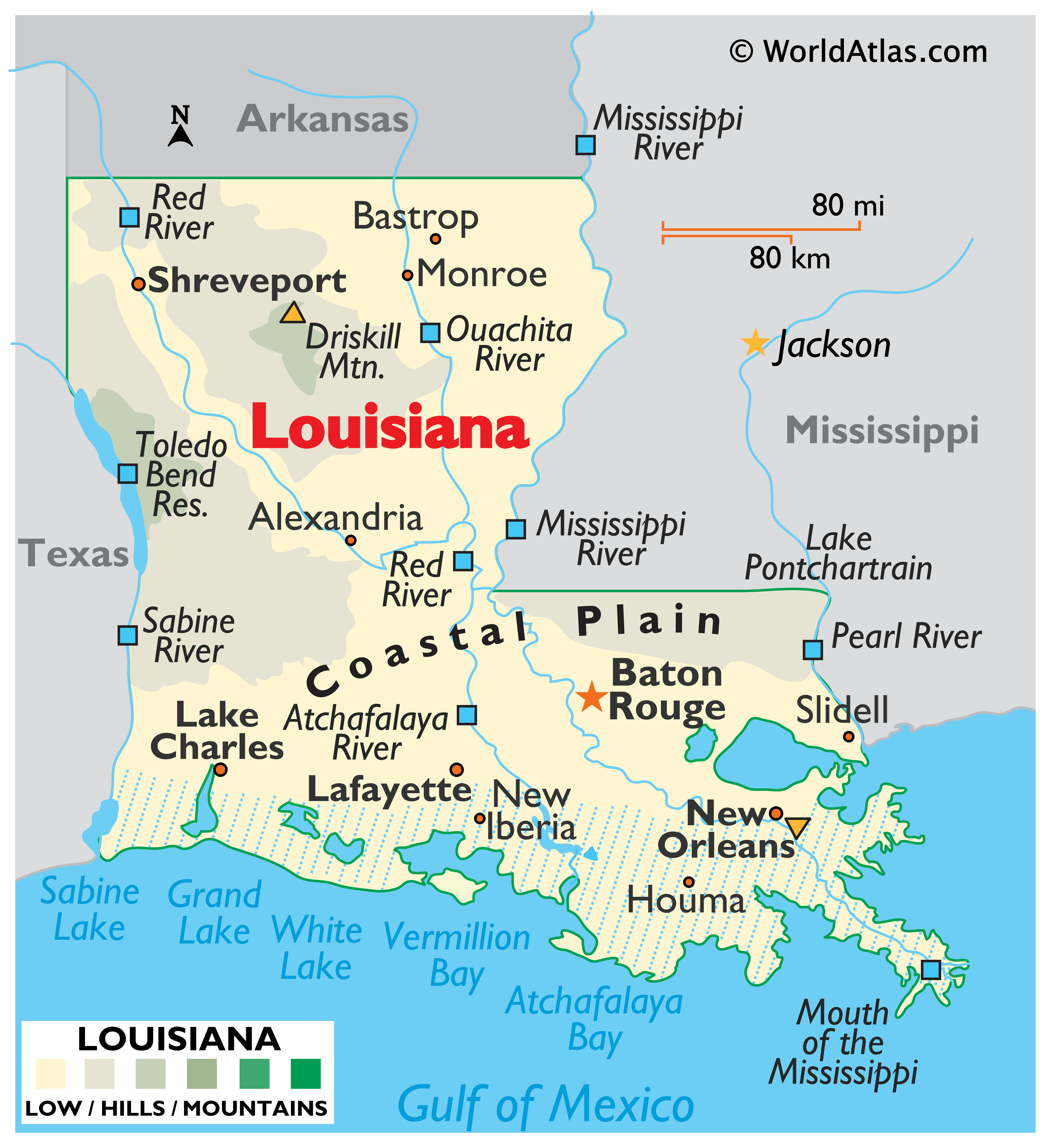
The most common way people identify Louisiana on a map is by its “boot” shape. The “toe” of the boot points eastward toward the Mississippi border, while the “heel” rests against the Gulf of Mexico. The “top” of the boot forms a straight line against Arkansas. This jagged and iconic shape is largely the result of natural water boundaries. The southern coast is not a solid line but a delicate, lacy fringe of marshes and bayous that have been shaped over millennia by the silt deposits of the Mississippi River.
Bordering States and Waterways
Louisiana is bordered by three states and one major body of water. To the west lies Texas, with the Sabine River forming much of the southern portion of that boundary. To the north is Arkansas, separated by the 33rd parallel north. To the east, Mississippi shares a long border, much of which is defined by the winding path of the Mississippi River and the Pearl River in the southeast. The entire southern boundary of the state is defined by the Gulf of Mexico, which provides the state with its vital ports and rich seafood industry.
Major Destinations and Urban Landmarks
When navigating the map of Louisiana, several key urban centers stand out as primary destinations for travelers. These cities are not just points on a grid; they are cultural epicenters that offer distinct experiences based on their geographical location within the state.
New Orleans and the Gulf Coast
Located in the southeastern “toe” of the boot, New Orleans is perhaps the most famous destination in the state. On a map, you will see it nestled between the Mississippi River and Lake Pontchartrain. This “Crescent City” is home to the world-renowned French Quarter, where travelers flock to see the historic St. Louis Cathedral and the bustling Jackson Square. Just a short distance from the neon lights of Bourbon Street, visitors can explore the oak-lined avenues of the Garden District, showcasing some of the finest antebellum architecture in the United States.
Baton Rouge: The Capital on the Bluffs
Heading northwest from New Orleans along the river, you find Baton Rouge. As the state capital, it is strategically located on the first set of bluffs above the Mississippi River delta, protecting it from the frequent flooding that affects the lower coast. It serves as a major industrial and political hub, bridging the gap between the coastal wetlands and the rolling hills of the north.
The Hub Cities of the North and West
In the northwest corner of the state, near the borders of Texas and Arkansas, lies Shreveport. Along with its sister city, Bossier City, it serves as the primary gateway to the “Sportsman’s Paradise” region. Moving south toward the coast, Lake Charles sits in the southwest, known for its petrochemical industry and thriving casino resorts. In the northeast, Monroe anchors the Ouachita River valley, while Alexandria sits almost exactly in the center of the state, serving as a crossroads for travelers moving in any direction.
Diverse Landforms and Natural Attractions
The map of Louisiana is a tapestry of water and earth. While many perceive the state as entirely flat, its geography is surprisingly varied, ranging from coastal marshes to the highest point in the state at Driskill Mountain in the north.
The Mighty Mississippi River and its Delta
The Mississippi River is the defining feature of Louisiana. It enters the state in the northeast and carves a serpentine path down to the Gulf of Mexico. The river’s delta is a massive bird-foot-shaped extension into the sea, where the land is constantly shifting. This area is essential for migratory birds and offers some of the best deep-sea fishing access in the world.
Swamplands and the Atchafalaya Basin
Between Lafayette and Baton Rouge lies the Atchafalaya Basin, the largest wetland and swamp in the United States. On a map, this area appears as a vast green expanse webbed with rivers and lakes. It is a prime destination for airboat tours, wildlife photography, and experiencing the raw, prehistoric beauty of cypress-tupelo swamps. Nearby, travelers can visit Avery Island, a salt dome famous as the home of Tabasco sauce and a sanctuary for snowy egrets.
Coastal Marshes and the Gulf Islands
The southern edge of the map features a complex system of barrier islands and coastal marshes. Grand Isle, Louisiana’s only inhabited barrier island, is a popular spot for birdwatching and beachcombing. To the west, the Chenier Plain features unique ridges of ancient oak trees growing out of the marshland, a phenomenon seen in few other places on earth.
Regional Divisions: Navigating Culture and Terrain
Louisiana is often divided into distinct cultural and geographical regions, each offering a different vibe for the intrepid traveler. Understanding these divisions helps clarify where to go based on your interests.
Acadiana and the Cajun Prairie
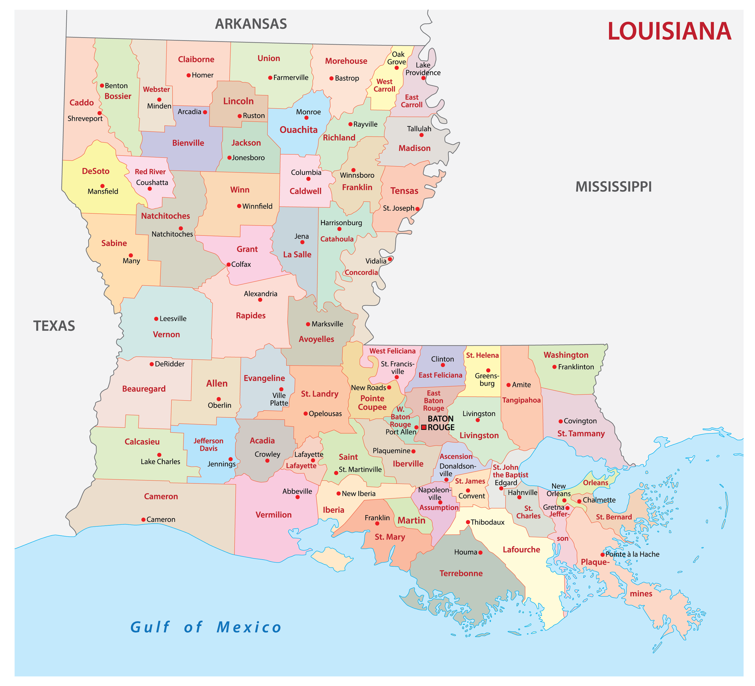
The southern and southwestern portion of the state is known as Acadiana. Centered around the city of Lafayette, this region is the heart of Cajun culture. If you look at the map, this area encompasses the coastal parishes and the “Cajun Prairie.” It is where you go for zydeco music, boudin, and a landscape dominated by Vermilion Bay and the lower Atchafalaya River.
Sportsman’s Paradise and the Crossroads
The northern half of Louisiana is known as “Sportsman’s Paradise.” This region looks very different on a map than the south; it is characterized by rolling hills, pine forests, and large inland lakes like Toledo Bend Reservoir on the Texas border. Between the north and the south lies the “Crossroads” region, home to Natchitoches, the oldest settlement in the Louisiana Purchase. Located along the Cane River, Natchitoches offers a glimpse into the colonial history of the region before it became part of the United States.
Planning Your Trip Across the Pelican State
Knowing where Louisiana is on a map is the beginning of a logistical journey. Because of its unique geography, travel within the state requires some strategic planning, particularly regarding the waterways that both define and divide the land.
Strategic Travel Hubs and Transportation
For most international and domestic travelers, the Louis Armstrong New Orleans International Airport is the primary point of entry. From there, the I-10 corridor serves as the main east-west artery, connecting New Orleans, Baton Rouge, Lafayette, and Lake Charles. For those heading north, I-49 provides a direct route from Lafayette through Alexandria up to Shreveport. Travelers should be aware that the “toe” of the boot is quite isolated; driving from New Orleans to the western border can take several hours due to the expansive wetlands and the need for long bridges, such as the Atchafalaya Basin Bridge, which spans 18 miles of swamp.
Seasonal Geography: Festivals and Weather Patterns
When planning where to go on the Louisiana map, timing is everything. The southern part of the state is subtropical, meaning it is hot and humid for much of the year. Travelers often prefer visiting during the cooler months from October to April. This period also coincides with the state’s most famous festivals. While Mardi Gras in New Orleans is the most famous, every corner of the map has its own celebration, from the International Rice Festival in Crowley to the Natchitoches Christmas Festival.
Louisiana is a state that defies simple categorization. It is a place where the Mississippi River meets the sea, where French and Spanish roots mingle with Caribbean and African influences, and where the map itself is a living, breathing entity. Whether you are navigating the historic streets of New Orleans, exploring the wild depths of the Atchafalaya Basin, or fishing the waters of the Gulf of Mexico, finding Louisiana on a map is just the start of an unforgettable adventure.
LifeOutOfTheBox is a participant in the Amazon Services LLC Associates Program, an affiliate advertising program designed to provide a means for sites to earn advertising fees by advertising and linking to Amazon.com. Amazon, the Amazon logo, AmazonSupply, and the AmazonSupply logo are trademarks of Amazon.com, Inc. or its affiliates. As an Amazon Associate we earn affiliate commissions from qualifying purchases.