
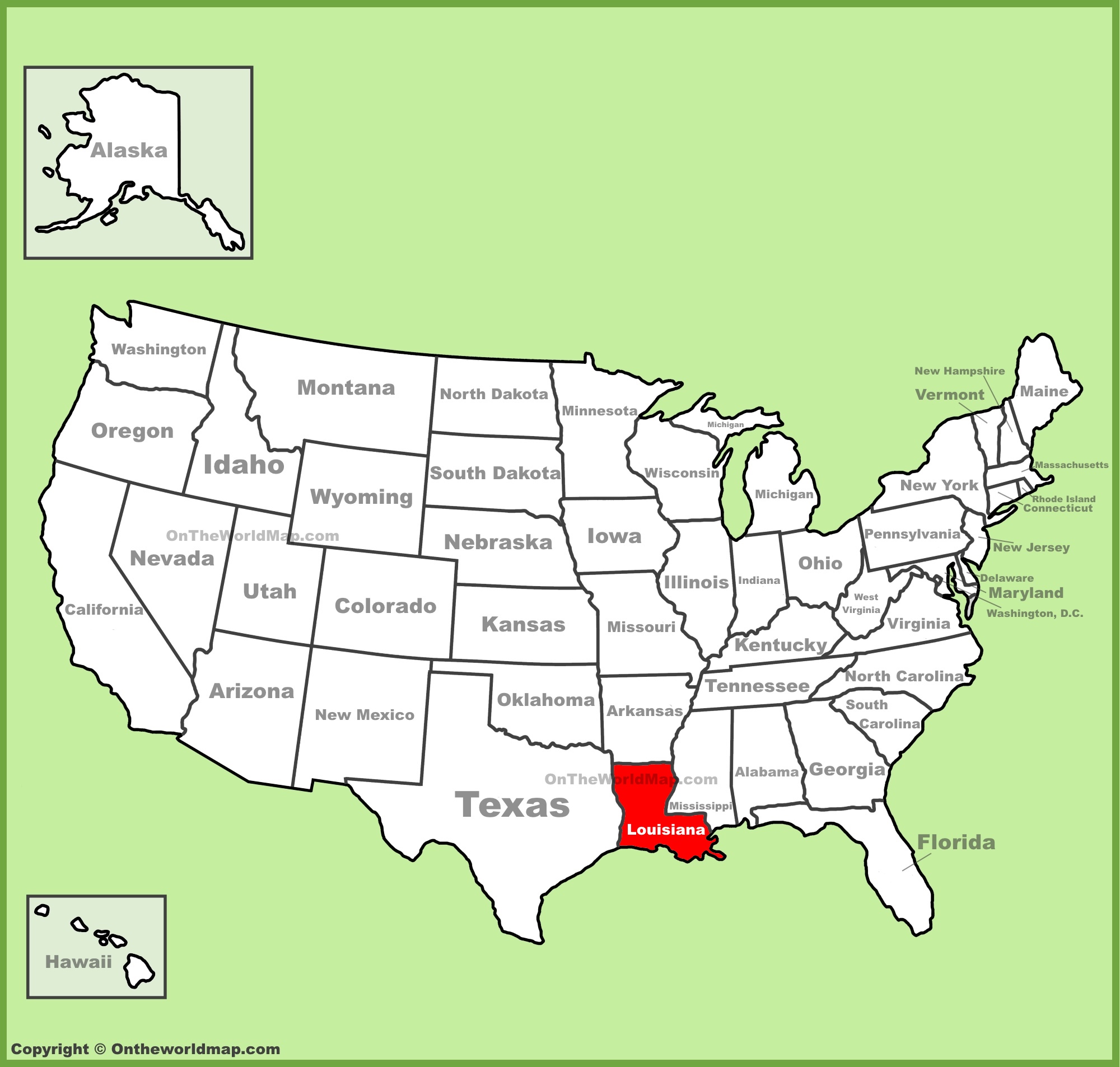
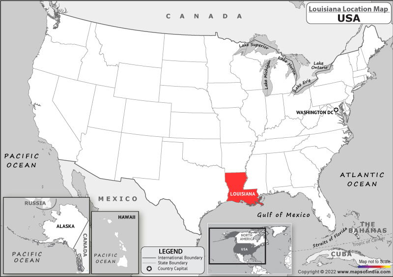
The question “Where Is Louisiana On The US Map?” might seem straightforward, but it unlocks a gateway to understanding a state brimming with unique culture, captivating landscapes, and a profound historical narrative. Louisiana occupies a distinctive position in the southeastern United States, nestled along the Gulf of Mexico. Its geographical placement is not merely a matter of coordinates; it profoundly influences its climate, biodiversity, cultural fusion, and its very identity. Understanding Louisiana’s location is the first step in appreciating its role as a vibrant crossroads of American life.
A Strategic Gulf Coast Position
Louisiana’s southern border is defined by the vast Gulf of Mexico, a crucial factor shaping its economy, climate, and historical development. This coastal access has historically made it a vital hub for trade and transportation. The Mississippi River, the longest river in North America, flows through the heart of Louisiana, emptying into the Gulf of Mexico via a sprawling delta. This river system is an economic artery, facilitating the movement of goods and people for centuries.
Defining Boundaries and Neighbors
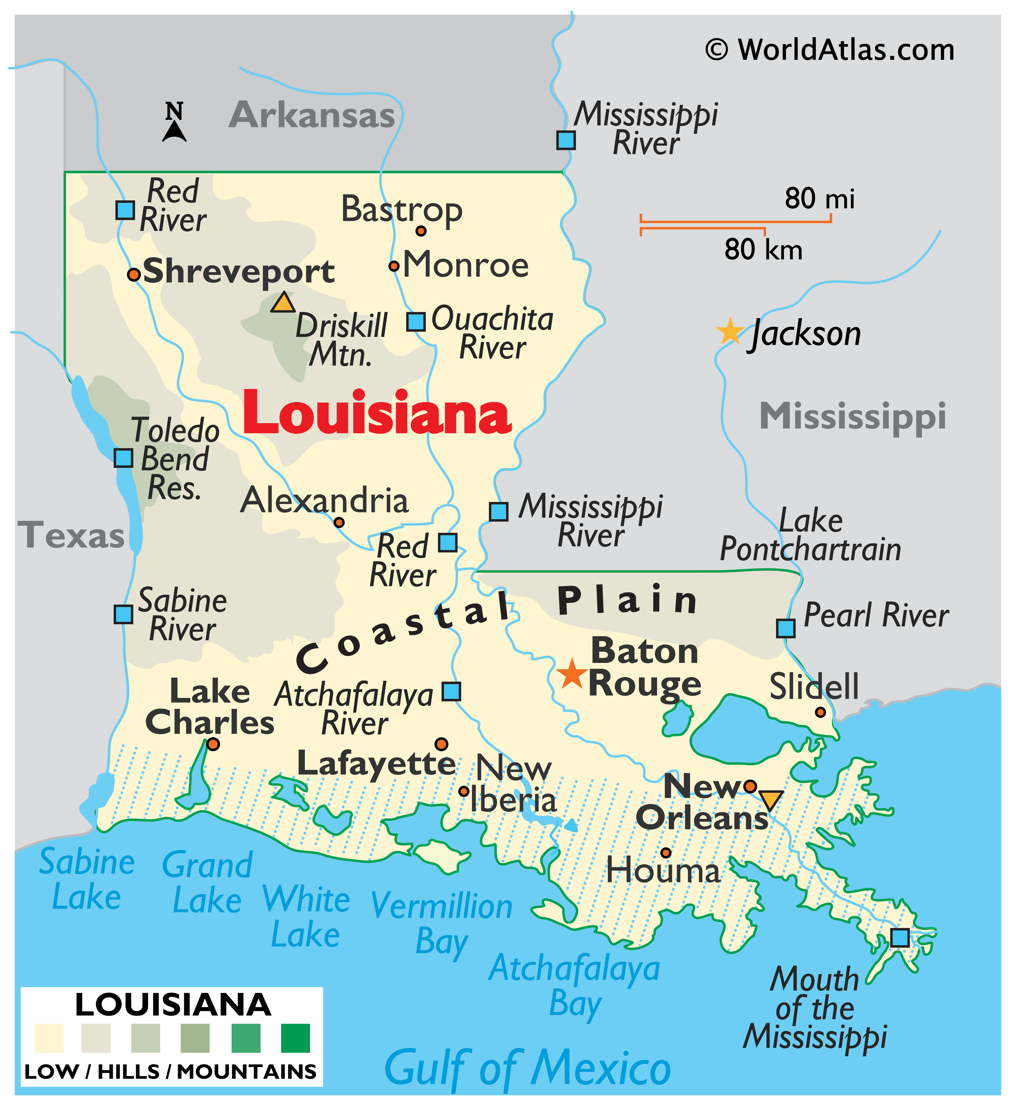
To pinpoint Louisiana’s location, consider its neighboring states. To the west lies Texas, a state known for its vastness and distinct cultural influences. To the north, Arkansas provides a border, sharing a similar but distinct Southern character. To the east, across the Pearl River, is Mississippi, another state deeply rooted in Southern traditions and history. These borders are not just lines on a map but represent regions with shared histories and evolving cultural exchanges.
The Significance of the Mississippi River Delta
The Mississippi River Delta is perhaps the most defining geographical feature of Louisiana. This vast, fertile region is formed by sediment deposited by the river over millennia, creating a unique and ever-changing landscape of wetlands, bayous, and barrier islands. This ecosystem is a biodiversity hotspot, supporting an incredible array of wildlife, from migratory birds to marine life. The delta’s intricate network of waterways has profoundly shaped human settlement patterns, leading to communities that are deeply intertwined with the water. The delta’s fertile soil also historically supported extensive agriculture, a cornerstone of the state’s economy.
Louisiana’s Cultural Crossroads
Louisiana’s geographical position at the confluence of North American waterways and its historical role as a port of entry have fostered an unparalleled cultural mosaic. Its location facilitated the arrival and intermingling of diverse peoples, including Native American tribes, French colonists, Spanish rulers, African slaves, and later immigrants from Ireland, Germany, and Italy. This rich blend is most famously expressed in its unique cuisine, music, and vibrant festivals.
The French and Spanish Legacy
The historical presence of France and Spain as colonial powers in Louisiana has left an indelible mark. The French influence is most evident in the Cajun culture of southwestern Louisiana, characterized by its distinct dialect, hearty cuisine, and lively accordion music. The Creole culture, more prevalent in New Orleans, showcases a sophisticated fusion of French, Spanish, African, and Caribbean traditions. This dual heritage is a direct result of Louisiana’s strategic position along important trade routes and its appeal to various European powers seeking control of North American territories.
African and Caribbean Rhythms
The forced migration of enslaved people from West Africa and the subsequent cultural exchange with Caribbean islands brought profound musical and culinary traditions to Louisiana. The rhythms of jazz, blues, and zydeco are deeply rooted in African musical heritage, evolving and flourishing in the fertile cultural soil of places like New Orleans. Similarly, many iconic Louisiana dishes, such as gumbo and jambalaya, owe their complexity and flavor profiles to African and Caribbean culinary influences, blended with European techniques.
A Tapestry of Traditions
Beyond these dominant influences, Louisiana’s history as a gateway has allowed for the absorption and integration of numerous other cultural threads. The agricultural heritage brought by various immigrant groups, the distinct fishing traditions of coastal communities, and the vibrant indigenous cultures of its earliest inhabitants all contribute to the state’s rich and multifaceted identity. Understanding Louisiana’s map is also about understanding the interplay of these diverse cultural forces that have shaped its soul.
Economic Significance and Natural Resources
Louisiana’s location has profoundly influenced its economic trajectory, primarily through its abundant natural resources and its strategic access to major transportation networks. The state is a powerhouse in energy production and agriculture, with its geography playing a central role in both.
The Energy Heartland
Louisiana is a leading producer of oil and natural gas in the United States. The offshore drilling platforms in the Gulf of Mexico and the extensive network of pipelines crisscrossing the state are testament to its status as an energy hub. The Mississippi River serves as a critical conduit for transporting these energy resources to markets across the nation and the world. Furthermore, the state’s extensive wetlands and coastal areas are vital for its fishing and seafood industries, adding another dimension to its economic landscape.
Agricultural Bounty
The fertile lands of the Mississippi River Delta and the rich soil across the state have made agriculture a perennial pillar of Louisiana’s economy. The state is a major producer of sugarcane, rice, soybeans, and cotton. The agricultural output is intrinsically linked to the state’s waterways, which facilitate irrigation and the transportation of harvested crops. The unique climate, influenced by its Gulf Coast position, also allows for a diverse range of agricultural products, including a world-renowned produce selection in the southern regions.
The Port of South Louisiana and Beyond
The Port of South Louisiana is one of the busiest ports in the world by tonnage, highlighting Louisiana’s critical role in domestic and international trade. Its strategic location on the Mississippi River, with direct access to the Gulf of Mexico, makes it an essential hub for the import and export of commodities, including grain, petroleum, and chemicals. Other significant ports, like the Port of New Orleans, further solidify the state’s importance in global commerce. This extensive network of ports and waterways, all connected to its position on the map, underpins much of the state’s economic prosperity.
Navigating Louisiana: Beyond the Map
To truly understand where Louisiana is on the US map is to recognize that it is far more than just a geographical marker. It is a state that exists at the nexus of powerful natural forces and diverse human histories. Its bayous, its bustling port cities, its historic plantations, and its vibrant cultural enclaves all tell a story of adaptation, resilience, and a unique way of life.
The Allure of the Bayou State
The term “Bayou State” evokes images of languid waterways, Spanish moss-draped trees, and the distinctive charm of its rural communities. These bayous, a unique feature of the Louisiana landscape, are slow-moving or stagnant bodies of water, often shallow and choked with vegetation. They are integral to the state’s identity, shaping its transportation, its folklore, and its very pace of life. Exploring these waterways, whether by kayak or guided tour, offers an intimate connection to the natural beauty and secluded pockets of culture that define much of Louisiana.
Cities of Character and Charm
Louisiana boasts cities with distinct personalities, each reflecting different facets of the state’s rich heritage. New Orleans, of course, is the crown jewel, a city renowned for its vibrant music scene, historic architecture, and world-class culinary offerings. But beyond New Orleans, cities like Baton Rouge, the state capital, offer a glimpse into Louisiana’s political and administrative heart. Shreveport in the northwest showcases a different cultural flavor, influenced by its proximity to Texas and its own burgeoning arts scene. Each city, from the smallest fishing village to the largest metropolis, contributes to the intricate tapestry of Louisiana.
Experiencing Louisiana’s Culture Firsthand
To truly grasp Louisiana’s place on the map, one must experience its culture. This means indulging in its legendary cuisine, from the spicy delights of Cajun country to the refined Creole dishes of New Orleans. It means immersing oneself in its unique musical traditions, whether it’s the infectious rhythms of a jazz funeral in New Orleans or the soulful strains of a zydeco band in southwest Louisiana. It means participating in its world-famous festivals, like Mardi Gras in New Orleans or the many vibrant celebrations that dot the calendar across the state. These experiences are the living embodiment of Louisiana’s position as a vibrant cultural crossroads.
In essence, Louisiana on the US map is not just a point of reference, but a destination that beckons with its unparalleled blend of natural beauty, historical depth, and a culture that is unlike any other in America. Its unique geographical position has sculpted its past, defines its present, and promises a captivating future for all who seek to explore its rich offerings.
LifeOutOfTheBox is a participant in the Amazon Services LLC Associates Program, an affiliate advertising program designed to provide a means for sites to earn advertising fees by advertising and linking to Amazon.com. Amazon, the Amazon logo, AmazonSupply, and the AmazonSupply logo are trademarks of Amazon.com, Inc. or its affiliates. As an Amazon Associate we earn affiliate commissions from qualifying purchases.