
The Mississippi River is more than just a body of water; it is a colossal natural landmark, a foundational element of North American geography, history, and culture. Spanning over 2,300 miles from its humble beginnings in Minnesota to its grand delta in Louisiana, it carves a defining path through the heart of the United States. For anyone seeking to comprehend the vastness of the American continent, to delve into its historical narratives, or to appreciate its ecological diversity, understanding the Mississippi River’s geographical expanse is paramount. A “map” of the Mississippi River is not merely a visual representation; it is a key to unlocking the story of a nation, revealing the intricate connections between land, water, and human endeavor. This monumental landmark has shaped economies, influenced migrations, inspired literature, and remains a vibrant, living entity vital to the continent’s well-being.
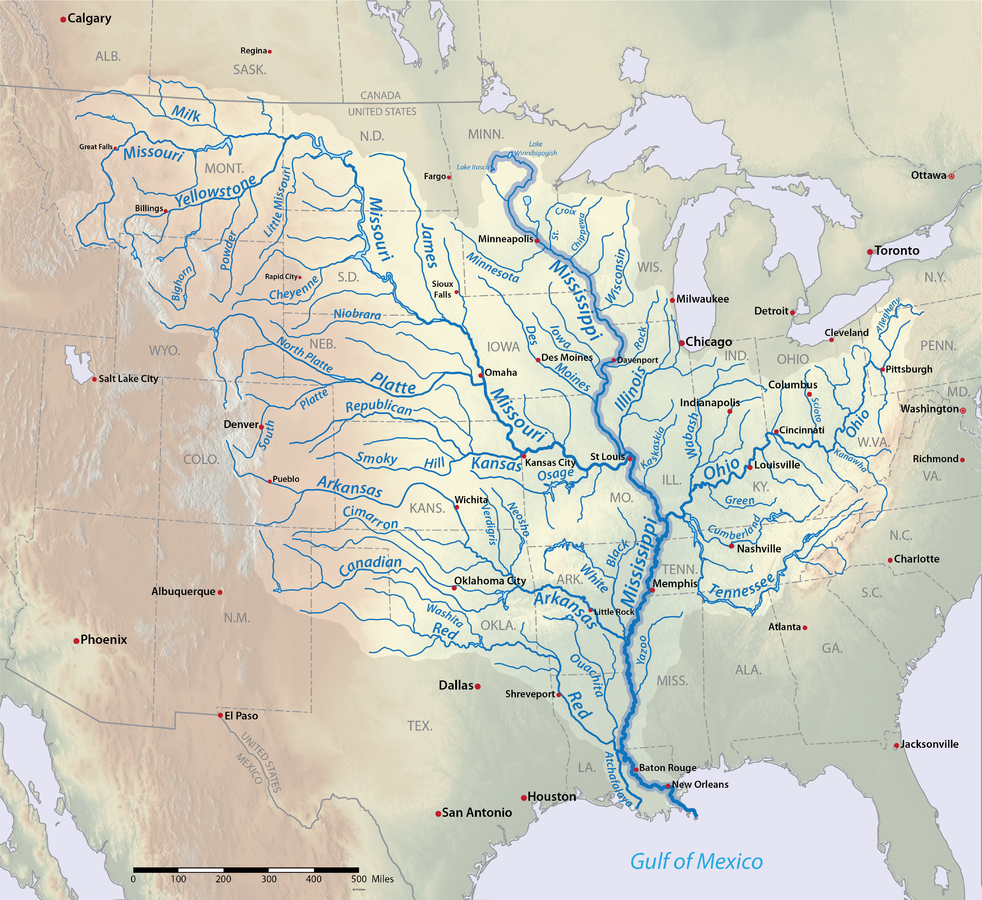
Tracing the Lifeline: The Geography of the Mississippi River
To truly grasp the significance of the Mississippi River as a landmark, one must first appreciate its immense geographical scope. From its elusive source to its dramatic end, the river traverses a diverse range of landscapes, climates, and ecosystems, making it a geographical marvel.
From Headwaters to Gulf
The journey of the Mississippi River begins humbly as a narrow stream flowing out of Lake Itasca in northern Minnesota. This specific point, marked by a small set of rocks and a mere trickle, belies the immense power and scale the river will achieve. From Lake Itasca, it flows northward for a short distance before turning south, beginning its epic descent towards the Gulf of Mexico. Along its course, it either flows through or borders ten states: Minnesota, Wisconsin, Iowa, Illinois, Missouri, Kentucky, Tennessee, Arkansas, Mississippi, and Louisiana. Each segment of the river presents unique characteristics, from the rocky bluffs and forested shores of its upper reaches to the broad, slow-moving expanse of its lower course, eventually fanning out into the marshy Mississippi River Delta as it empties into the Gulf of Mexico. The length of this journey, approximately 2,340 miles (3,766 kilometers), makes it the second-longest river in North America, surpassed only by its longest tributary, the Missouri River.
The Vast Drainage Basin
Perhaps even more impressive than its length is the sheer scale of the Mississippi River Basin, also known as the Mississippi River watershed. This vast drainage system encompasses over 1.2 million square miles, covering roughly 41% of the contiguous United States and parts of two Canadian provinces. It is the fourth-largest drainage basin in the world. Within this immense area, the Mississippi River is fed by countless tributaries, large and small, that funnel water from the Rocky Mountains in the west to the Appalachian Mountains in the east. Key among these tributaries are the Missouri River, which joins the Mississippi north of St. Louis, Missouri, and the Ohio River, which converges with it near Cairo, Illinois. These mighty rivers, along with others like the Arkansas River and Red River, contribute significantly to the Mississippi’s flow, volume, and sediment load, illustrating its interconnectedness across a vast geographical network.
Mapping the Delta and Floodplain
As the Mississippi River approaches the Gulf of Mexico, its character changes dramatically, culminating in the expansive Mississippi River Delta. This is a dynamic, ever-changing landscape of wetlands, bayous, and distributaries, where the river’s accumulated sediment creates new land and supports an incredibly rich ecosystem. The delta is not static; it constantly shifts due to natural processes like sedimentation and subsidence, and human interventions like levees and dredging. Upstream from the delta, the river has also sculpted an immense floodplain, particularly prominent in the lower Mississippi Valley. This floodplain, historically subject to annual inundation, has deposited incredibly fertile alluvial soils, transforming the region into one of the most productive agricultural areas in the United States. Understanding these geomorphological features is crucial to appreciating the river as a landmark, highlighting its role not only as a channel for water but as a builder of land.
A River Through Time: Historical Significance as a Landmark
The Mississippi River’s status as a landmark is not solely defined by its physical attributes; it is profoundly interwoven with the historical development of North America. For millennia, and particularly since European arrival, the river has been a silent witness and an active participant in the unfolding drama of human civilization.
Indigenous Heritage
Long before European explorers charted its course, the Mississippi River was the lifeblood for numerous indigenous cultures. For thousands of years, Native American tribes thrived along its banks, relying on its abundant resources for sustenance, transportation, and cultural practices. Settlements like Cahokia, near modern-day St. Louis, grew into vast, complex urban centers supported by the river’s fertile lands and trade routes. The river was a spiritual entity, a provider, and a connector for peoples like the Choctaw, Chickasaw, Quapaw, Osage, Sioux, and many others. Their mounds, artifacts, and oral traditions still speak to the deep and enduring relationship between indigenous populations and this great river.
Exploration and Settlement
The arrival of Europeans dramatically altered the history of the Mississippi. Spanish explorer Hernando de Soto is credited as the first European to document encountering the river in 1541, although indigenous people had known and used it for millennia. Later, in the late 17th century, French explorers Jacques Marquette and Louis Jolliet extensively mapped its upper reaches, followed by Robert de La Salle, who claimed the entire Mississippi River Basin for France in 1682, naming it “Louisiana” after King Louis XIV. The river became a crucial strategic waterway, hotly contested by European powers. Its acquisition by the United States through the Louisiana Purchase in 1803 was a monumental event, doubling the size of the young nation and opening up vast territories for westward expansion, forever cementing the river’s role in American identity.
Economic Lifeline and Transportation Artery

Throughout the 18th, 19th, and 20th centuries, the Mississippi River served as the preeminent transportation artery and economic lifeline for the burgeoning United States. Steamboats, immortalized by authors like Mark Twain, plied its waters, carrying goods, people, and ideas, fostering the growth of iconic river cities such as St. Louis, Memphis, and New Orleans. These cities became bustling hubs of commerce, culture, and innovation, their prosperity inextricably linked to the river’s flow. Even today, the Mississippi River remains a vital commercial waterway, with barges transporting billions of tons of agricultural products, petroleum, and other commodities, underscoring its enduring economic importance.
Ecological Tapestry: The Mississippi River’s Natural Wonders
Beyond its geographical and historical grandeur, the Mississippi River is a natural landmark of immense ecological value. Its diverse environments support an incredible array of plant and animal life, making it a critical biodiversity hotspot.
Diverse Habitats
The varied course of the Mississippi River creates a mosaic of habitats, each supporting unique ecological communities. In the northern reaches, extensive wetlands, bogs, and coniferous forests characterize the landscape. Moving south, floodplains give way to deciduous forests, prairies, and agricultural lands. The lower Mississippi region, particularly the delta, is famous for its intricate system of bayous, swamps, and marshes, home to iconic Southern ecosystems. This ecological gradient, dictated by latitude, hydrology, and geology, makes the river a microcosm of North American natural diversity.
Flora and Fauna
The biodiversity supported by the Mississippi River is astonishing. It is a critical migratory flyway for millions of birds, connecting breeding grounds in the Arctic to wintering areas in Central and South America. Over 325 bird species, including bald eagles, pelicans, and various waterfowl, rely on the river and its associated wetlands. Its waters are home to over 145 species of fish, including unique species like the paddlefish and ancient sturgeon, as well as abundant catfish, bass, and carp. The riparian zones provide habitat for mammals such as white-tailed deer, raccoons, beavers, and even black bears in some areas. In the southern swamps, alligators, turtles, and numerous amphibian species thrive. The river’s ecosystem is a delicate balance, where countless species are interdependent on its health and flow.
Conservation Efforts and Challenges
Despite its grandeur, the Mississippi River faces significant environmental challenges, underscoring the importance of its preservation as a natural landmark. Agricultural runoff from its vast watershed contributes to nutrient pollution, creating a hypoxic “dead zone” in the Gulf of Mexico that threatens marine life. Industrial pollution, habitat loss due to development, and the alteration of its natural flow by dams and levees also pose serious threats. Recognizing its profound ecological value, numerous conservation efforts are underway, involving government agencies, NGOs, and local communities. These initiatives focus on wetland restoration, sustainable agricultural practices, pollution reduction, and protecting critical habitats to ensure the long-term health and vitality of this irreplaceable natural landmark.
Experiencing the Mississippi River Today: Understanding its Scale
While a map provides the geographical coordinates, experiencing the Mississippi River in person offers a visceral understanding of its monumental scale and profound impact. It allows one to connect with its status as a living, breathing landmark.
Scenic Drives and Overlooks
For those seeking to appreciate the river’s majesty, numerous vantage points offer breathtaking views. The Great River Road, a national scenic byway, traces the river’s course for its entire length, offering unparalleled access and interpretive opportunities. Travelers can drive through quaint river towns, past historic sites, and alongside stunning natural vistas. Strategic overlooks and state parks along the river in states like Wisconsin, Iowa, and Mississippi provide ideal spots for reflection and photography, allowing visitors to grasp the sheer width and power of the waterway.
Museums and Interpretive Centers
To delve deeper into the river’s multifaceted story, numerous museums and interpretive centers are dedicated to its history, ecology, and cultural significance. The National Mississippi River Museum & Aquarium in Dubuque, Iowa, offers comprehensive exhibits on the river’s ecosystems and history. Similarly, institutions in St. Louis, Memphis, and New Orleans provide invaluable insights into its role in urban development, transportation, and culture. These centers serve as vital educational resources, enhancing the understanding and appreciation of the Mississippi River as a landmark of national importance.

Navigating the River
For an even more intimate experience, navigating the river itself provides a unique perspective. While barge traffic dominates commercial use, recreational opportunities abound. From kayaking and canoeing in calmer backwaters to taking guided river cruises, particularly in tourist-friendly cities like New Orleans, experiencing the river from its surface underscores its powerful flow and the vastness of its journey. Observing the changing landscapes from the water, from the steep bluffs of the upper Mississippi to the sprawling wetlands of its delta, offers an unforgettable encounter with this iconic natural landmark.
In conclusion, the question “Where Is Mississippi River Map?” leads to a profound exploration of one of the world’s most significant natural landmarks. It is not just a geographic feature but a historical tapestry, an ecological powerhouse, and an enduring symbol of the United States. Its immense scale, rich history, and critical ecological role cement its status as an unparalleled landmark that continues to shape the continent’s landscape and identity. Understanding the Mississippi River is to understand the heart of America itself.
LifeOutOfTheBox is a participant in the Amazon Services LLC Associates Program, an affiliate advertising program designed to provide a means for sites to earn advertising fees by advertising and linking to Amazon.com. Amazon, the Amazon logo, AmazonSupply, and the AmazonSupply logo are trademarks of Amazon.com, Inc. or its affiliates. As an Amazon Associate we earn affiliate commissions from qualifying purchases.