
Unveiling the Geographic Significance of Palmer Divide
The Palmer Divide stands as a prominent and often underestimated natural landmark in the heart of Colorado. Far more than just a topographic feature, it is a critical geological formation that profoundly influences the state’s climate, ecosystems, and human settlement patterns. Geologically, the Palmer Divide is an elevated landform, a broad, relatively gentle uplift that stretches across a significant portion of the Front Range urban corridor. It’s essentially an eastward extension of the Rocky Mountains in terms of its high elevation, but without the dramatic peaks and rugged terrain typical of the higher ranges. Instead, it presents as a high-elevation plateau, rising gradually from the surrounding plains and creating a distinct crest.

At its core, the Palmer Divide serves as a major watershed divide. It separates the drainage basins of the South Platte River to the north from those flowing into the Arkansas River to the south. This hydrological separation is fundamental to the region’s water resources and flow, directing precipitation and runoff in two distinct directions towards the larger river systems that ultimately feed into the Mississippi River basin. The divide’s unique geological characteristics stem from its formation millions of years ago, a complex interplay of tectonic uplift, erosion, and deposition. Ancient seas once covered this area, leaving behind sedimentary layers that were later uplifted and sculpted by the forces of nature, resulting in the distinctive topography visible today. The erosional processes have exposed varying rock types, contributing to the diverse soil compositions found across the divide. Understanding the Palmer Divide means appreciating its role as a natural barrier, a climatic influencer, and a defining element of the central Colorado landscape. Its significance as a natural landmark lies not just in its physical presence, but in its pervasive impact on everything from weather patterns to historical migration routes.
Locating Palmer Divide: A Crucial Colorado Landmark
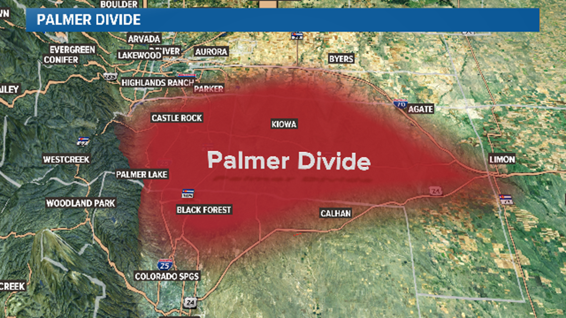
The Palmer Divide is strategically located in central Colorado, acting as a natural high point between the two largest metropolitan areas of the state: Denver to the north and Colorado Springs to the south. Its broad sweep makes it a pervasive presence across several counties, primarily traversing El Paso County, Douglas County, and extending into the western fringes of Elbert County. This geographical positioning places it at the crossroads of significant human activity and natural splendor.
To pinpoint its location, one can imagine a line extending roughly east-southeast from the foothills west of Denver, running between Castle Rock and Colorado Springs, and then curving eastward towards the high plains. The most easily identifiable stretch of the divide for travelers is along the I-25 corridor, particularly between the towns of Castle Rock and Monument. Here, the highway climbs noticeably, reaching its highest elevation within this stretch, often providing panoramic views of the Rocky Mountains to the west and the rolling plains to the east.
Numerous towns and communities are situated directly on or in close proximity to the Palmer Divide, their identities often shaped by its presence. From north to south, these include the historic railroad town of Larkspur, the growing town of Monument, and the scenic village of Palmer Lake, which sits at one of the highest points of the divide and is known for its namesake lake. Further east, communities like Elizabeth, Kiowa, and Franktown also reside on the divide’s expansive plateau. These settlements benefit from the unique climatic conditions and often boast distinct natural characteristics due to their elevation. The accessibility of the Palmer Divide via major highways like I-25 and Highway 83 makes it a readily observable and integral landmark, experienced daily by thousands of commuters and appreciated by those who seek to understand Colorado’s diverse geography.
The Ecological and Climatic Influence of Palmer Divide
The Palmer Divide’s elevation and orientation make it a pivotal climatic barrier, casting a profound influence over regional weather patterns and shaping distinct ecosystems.
A Climatic Barrier
One of the most notable effects of the Palmer Divide is its impact on precipitation, particularly snowfall. As moist air masses approach from the east or south, they are forced to rise over the divide, leading to what is known as orographic lift. This process causes the air to cool, condense, and often deposit significantly more moisture on the divide’s higher elevations than on the surrounding plains or even areas immediately to the west. This phenomenon creates a localized “snow belt” where communities situated on the divide, such as Monument and Palmer Lake, frequently receive considerably heavier snowfalls compared to Denver or Colorado Springs. This increased snowfall provides crucial moisture for the local environment and contributes to unique microclimates characterized by cooler temperatures and stronger winds, especially during winter months. The divide acts as a meteorological front, frequently delineating zones of differing weather conditions across Colorado’s populous Front Range.
Ecosystems and Biodiversity
The distinct climatic conditions fostered by the Palmer Divide directly translate into diverse ecosystems and rich biodiversity. The cooler temperatures and increased moisture support vegetation types that contrast sharply with the drier shortgrass prairies found at lower elevations. Expansive Ponderosa pine forests are a signature feature of the divide, thriving on its slopes and plateaus. These iconic forests provide vital habitat for numerous wildlife species, including deer, elk, black bears, mountain lions, and a variety of birdlife. Interspersed with the forests are areas of mixed-grass prairie and shrublands, particularly on the eastern, drier flanks.

Riparian corridors along the streams and creeks that originate on the divide support lush growth of cottonwoods and willows, providing critical greenbelts for migratory birds and other animals. The divide is also crucial for water resources, serving as a recharge zone for local aquifers and acting as the headwaters for many smaller streams and tributaries that eventually feed into the larger South Platte and Arkansas River systems. This ecological mosaic makes the Palmer Divide not just a geological landmark, but a living, breathing landscape vital to the overall ecological health and water security of central Colorado.
Historical and Cultural Resonance of Palmer Divide
Beyond its geological and ecological significance, the Palmer Divide holds a deep historical and cultural resonance, serving as a silent witness to centuries of human activity and progress in Colorado.
Early Inhabitants and Exploration
Long before European American settlement, the Palmer Divide was an integral part of the ancestral lands of various Native American tribes. The Ute, Cheyenne, and Arapaho peoples utilized the divide for hunting, gathering, and as a travel corridor. Its higher elevation offered strategic viewpoints, and its forests and waterways provided essential resources. The natural springs and game sustained nomadic groups for millennia.
With the advent of European American exploration in the 19th century, the Palmer Divide became a landmark for early pioneers, trappers, and prospectors. It presented a formidable, yet navigable, barrier on the journey west. Its relatively gentle slopes, compared to the rugged Rocky Mountains to the west, made it a preferred route for wagon trains and later, for crucial transportation infrastructure. The divide played a pivotal role in westward expansion, dictating the paths of early trails and influencing where settlements would eventually form.
Development and Modern Significance
The true transformative impact of the Palmer Divide became evident with the arrival of the railroad. The construction of the Denver and Rio Grande Western Railroad across the divide in the late 19th century was a monumental engineering feat. This railway connected Denver and Colorado Springs, profoundly shaping the region’s economic development and growth. Towns like Palmer Lake and Monument grew up around these railroad stops, becoming important hubs for timber, agriculture, and later, tourism.
In the 20th and 21st centuries, the divide continues to influence urban planning and infrastructure. I-25, the main north-south artery in Colorado, carefully navigates the divide, encountering its steepest grades in this area. The development patterns of suburban communities in Douglas County and El Paso County have been intrinsically linked to the divide’s topography and its natural resources. Today, while much of the divide’s landscape has been touched by development, significant efforts are underway to preserve its natural beauty and ecological integrity through various open space initiatives and conservation easements, ensuring that its historical and natural legacy endures for future generations.
Experiencing Palmer Divide: A Landmark Worth Exploring
For those seeking to understand and engage with Colorado’s diverse geography, the Palmer Divide offers a unique and accessible experience. It’s a landmark that invites exploration, revealing its subtle grandeur through scenic drives, recreational pursuits, and contemplative moments.
One of the most straightforward ways to experience the divide is through its numerous scenic drives. Traveling along I-25 between Castle Rock and Colorado Springs provides continuous views of the divide’s rolling terrain, punctuated by Ponderosa pine forests and distant mountain vistas. For a more intimate experience, Highway 83, which parallels I-25 to the east, offers a quieter route through some of the most beautiful and undeveloped stretches of the divide, passing through charming rural communities like Franktown and Elizabeth.
Numerous parks and open spaces dot the landscape on and around the Palmer Divide, providing ample opportunities for outdoor recreation. Castlewood Canyon State Park, located just north of the divide in Douglas County, showcases dramatic geological formations carved by Cherry Creek, offering miles of hiking trails through Ponderosa pine forests and along the canyon rim. Further south, near Monument, areas like the Monument Rock Trail provide access to the divide’s signature rock formations and stunning views. These locations are ideal for hiking, mountain biking, and wildlife viewing, allowing visitors to immerse themselves in the distinct ecosystems of the divide. Birdwatching, in particular, is rewarding due to the diverse habitats.
The Palmer Divide offers unique perspectives on Colorado’s diverse landscape. From its elevated vantage points, one can simultaneously appreciate the vastness of the eastern plains and the majestic grandeur of the Rocky Mountains to the west. It’s a place where the prairie meets the forest, and where weather systems dramatically shift. Exploring the Palmer Divide is an opportunity to connect with a fundamental natural landmark that has shaped the region’s climate, ecology, and history, offering a deeper understanding of the complexities and beauties of Colorado.
LifeOutOfTheBox is a participant in the Amazon Services LLC Associates Program, an affiliate advertising program designed to provide a means for sites to earn advertising fees by advertising and linking to Amazon.com. Amazon, the Amazon logo, AmazonSupply, and the AmazonSupply logo are trademarks of Amazon.com, Inc. or its affiliates. As an Amazon Associate we earn affiliate commissions from qualifying purchases.