
The Mississippi River, often affectionately called the “Mighty Mississippi,” is far more than just a waterway; it is a colossal North American landmark, a historical artery, and an ecological marvel that has profoundly shaped the continent. For many, its name conjures images of steamboats, bustling port cities, and vast, fertile plains, but pinning down its precise journey on a map reveals a story of immense geographical influence and captivating natural beauty. Understanding its location is to unlock a fundamental piece of the United States’ landscape, history, and identity.
The Mighty Spine of North America: Tracing its Course
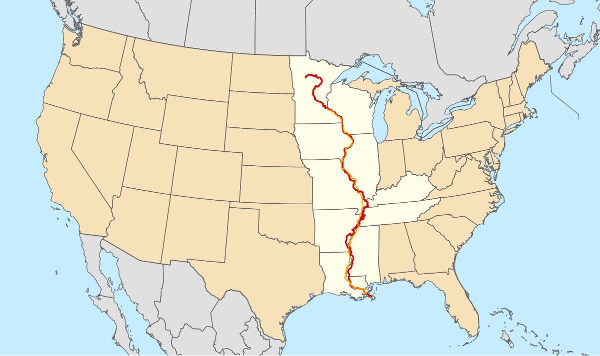
To locate the Mississippi River on a map is to observe a liquid spine stretching across the heartland of the United States, connecting diverse ecosystems and cultures from its frigid northern source to the warm southern sea. This immense river system is one of the world’s longest and most powerful, draining an area that spans parts of 32 U.S. states and two Canadian provinces. Its journey offers a panoramic view of the continent’s interior, defining boundaries, fostering life, and facilitating commerce for centuries.

Tracing its Origins: Lake Itasca
The humble beginnings of the Mississippi River can be found in a small, crystal-clear lake nestled within Itasca State Park in northern Minnesota. Lake Itasca, a relatively modest body of water, holds the profound distinction of being the official source of this legendary river. Here, the river starts as a shallow stream, easily stepped across by visitors eager to witness its nascent flow. From this tranquil woodland setting, at an elevation of about 1,475 feet (450 meters) above sea level, the nascent Mississippi embarks on its epic southward odyssey. This initial segment, meandering through forests and wetlands, offers a stark contrast to the colossal river it eventually becomes, highlighting the incredible transformation a natural landmark undergoes across its immense length. The journey from a trickling brook to a mighty river emphasizes the vast hydrological network that collects water from such a wide basin.
The Expansive Basin
As the Mississippi River flows southward from Minnesota, it gathers strength and volume from an astonishingly vast drainage basin, one of the largest in the world. This basin, often referred to as the Mississippi River Basin, covers more than 1.2 million square miles (3.1 million square kilometers). It encompasses all or parts of 32 U.S. states, from the Rocky Mountains in the west to the Appalachian Mountains in the east, and extends into parts of the Canadian provinces of Alberta and Saskatchewan. This immense watershed is fed by countless tributaries, large and small, that channel rainfall and snowmelt from across the continent into the main stem of the Mississippi. This intricate network of rivers and streams highlights the interconnectedness of North America’s water systems, making the Mississippi River a central hub for the continent’s hydrology.
Confluence with the Gulf of Mexico
After traversing approximately 2,340 miles (3,766 kilometers) and passing through or bordering ten U.S. states (Minnesota, Wisconsin, Iowa, Illinois, Missouri, Kentucky, Tennessee, Arkansas, Mississippi, and Louisiana), the Mississippi River finally empties into the Gulf of Mexico. This confluence occurs in a vast, sprawling delta region south of New Orleans, Louisiana. The Mississippi River Delta is a dynamic and ecologically rich area, constantly reshaped by the sediment deposited by the river. This terminal point is not a simple ending but a complex estuary system, where freshwater meets saltwater, creating unique habitats and contributing significantly to global biodiversity. The journey from Lake Itasca to the Gulf underscores the river’s monumental scale and its critical role in shaping the geology and ecology of the southern United States.
A Geographical Colossus: Understanding its Scale and Influence
Beyond merely its starting and ending points, grasping the true scale of the Mississippi River requires an appreciation for its dimensions, the sheer volume of water it carries, and the extensive network of tributaries that contribute to its might. It is a landmark defined not just by its path, but by its immense hydrological power and the vast territories it influences.
Length and Discharge
Measuring approximately 2,340 miles (3,766 kilometers) from Lake Itasca to the Gulf of Mexico, the Mississippi River stands as the second-longest river in North America (behind the Missouri River, which is its longest tributary). However, when combined with the Missouri River system, it forms the fourth-longest river system in the world. Its average discharge, the volume of water passing a given point per unit of time, is a staggering 593,000 cubic feet (16,800 cubic meters) per second near its mouth. This incredible volume makes it the largest river by discharge in North America and among the top ten globally. This massive flow not only sustains vast ecosystems but also represents an immense force that has historically been harnessed for power, transportation, and agriculture. The sheer magnitude of its discharge showcases the immense water collection capacity of its basin.
States Touched by the River
The Mississippi River acts as a natural boundary and lifeline for ten U.S. states along its main stem. Starting in Minnesota, it then forms the eastern border of Iowa and Missouri, separating them from Wisconsin and Illinois respectively. Further south, it divides Arkansas from Tennessee and Mississippi. Finally, it flows entirely through Louisiana before reaching the Gulf. This geographical characteristic has profoundly influenced the development, economy, and culture of these states, making the river a shared heritage and a defining feature of their landscapes. Cities like Minneapolis and St. Paul in Minnesota, St. Louis in Missouri, and New Orleans in Louisiana owe their very existence and prosperity to their strategic locations on the river.
Major Tributaries and Their Impact
The Mississippi River’s power and reach are magnified by its numerous major tributaries. The most significant among these is the Missouri River, which joins the Mississippi near St. Louis, Missouri, and effectively doubles its length and volume. The Ohio River, another major tributary, meets the Mississippi at Cairo, Illinois, contributing a significant portion of the Mississippi’s total flow. Other important tributaries include the Arkansas River, the Illinois River, and the Red River. These tributaries extend the reach of the Mississippi River Basin across vast agricultural lands, industrial centers, and urban areas, highlighting the river system’s indispensable role in the economy and ecology of the United States. Their combined waters not only shape the river’s character but also define the agricultural productivity and flood dynamics of the American heartland.
The Mississippi River: A Historical Lifeline
As a central North American landmark, the Mississippi River holds an irreplaceable position in the tapestry of human history. Its waters have witnessed centuries of indigenous life, facilitated European exploration, fueled economic development, and inspired countless cultural expressions. Understanding its historical significance is crucial to appreciating its identity as a landmark.
Indigenous Heritage and Early Exploration

Long before European arrival, the Mississippi River and its fertile floodplains were home to numerous indigenous nations, including the Choctaw, Chickasaw, Natchez, Tunica, Cahokia, and Dakota peoples. These communities relied on the river for food, transportation, and cultural sustenance, developing sophisticated societies along its banks. The river served as a natural highway, connecting diverse tribes and facilitating trade. European explorers, most notably Hernando de Soto in 1541 and Joliet and Marquette in 1673, were drawn to the river, seeking trade routes and new territories. Their expeditions marked the beginning of European colonization efforts, forever changing the landscape and the lives of indigenous peoples along the river. The river became a crucial strategic point for competing colonial powers, including France, Spain, and Great Britain.
Economic Engine and Transportation Artery
Throughout the 18th and 19th centuries, the Mississippi River became the primary transportation artery for the nascent United States. Agricultural products from the vast interior, such as cotton, timber, and grains, were floated downriver on barges and steamboats to southern ports like New Orleans for export. This facilitated the economic growth of the Midwest and South, making the river indispensable for national commerce. The advent of steamboats revolutionized river travel, creating a vibrant industry and a unique culture, famously immortalized by Mark Twain. Even today, the Mississippi River remains a vital commercial waterway, with barges carrying billions of tons of goods annually, demonstrating its enduring economic importance as a landmark.
Shaping Cities and Culture
The Mississippi River’s influence on urban development and cultural identity is profound. Major cities like Minneapolis and St. Paul, St. Louis, Memphis, and New Orleans grew up along its banks, their histories intertwined with the river’s flow. These cities developed unique identities influenced by river trade, diverse immigrant populations, and the natural challenges and opportunities presented by the waterway. The river has inspired countless works of literature, music, and art, from blues and jazz that originated in river towns to novels reflecting its grandeur and mysteries. The “river culture” – a blend of Southern charm, industrial grit, and natural resilience – remains a distinctive part of the American experience, testifying to the river’s enduring cultural landmark status.
Ecological Significance and Natural Wonders
The Mississippi River is not only a geographical and historical landmark but also an ecological powerhouse, supporting an incredible diversity of life across its vast basin. Its floodplains, wetlands, and delta create unique habitats crucial for numerous species, making it a critical component of North American biodiversity.
Biodiversity Hotspot
The Mississippi River System supports an astonishing array of flora and fauna. Its waters and riparian zones are home to over 260 species of fish, including paddlefish, sturgeon, and catfish, as well as mussels, turtles, and amphibians. The river corridor is a crucial migratory flyway for 40% of North America’s waterfowl and shorebirds, making it a birdwatcher’s paradise. Mammals like deer, beavers, and river otters thrive along its banks. The unique blend of habitats, from northern forests to southern cypress swamps, contributes to this rich biodiversity, establishing the river as a vital natural landmark that warrants protection.
Floodplains and Wetlands
The extensive floodplains and wetlands associated with the Mississippi River are invaluable ecological assets. These areas act as natural sponges, absorbing floodwaters, filtering pollutants, and providing critical nurseries for aquatic life. The Mississippi River Delta in Louisiana, a vast network of marshes, bayous, and barrier islands, is one of the most productive ecosystems on Earth, supporting enormous fisheries and providing hurricane protection for coastal communities. These natural features highlight the river’s complex role, balancing human interaction with critical ecological functions.
Conservation Efforts
Recognizing the immense ecological value and vulnerability of the Mississippi River, numerous conservation efforts are underway. Organizations, government agencies, and local communities are working to restore wetlands, improve water quality, protect endangered species, and manage the river sustainably. Challenges include pollution from agricultural runoff, habitat loss, and the impact of climate change. However, ongoing initiatives aim to preserve the river’s natural integrity for future generations, ensuring this magnificent landmark continues to thrive as a haven for wildlife and a source of natural beauty. Projects like the Upper Mississippi River National Wildlife and Fish Refuge exemplify dedicated commitments to conservation.
Experiencing the Landmark: Viewing Points and Perspectives
While its geographical location is fixed on a map, the experience of the Mississippi River is dynamic and multi-faceted. As a landmark, it offers countless opportunities for engagement, from panoramic overlooks to intimate river journeys, inviting visitors to connect with its grandeur and historical resonance.
Iconic Bridges and Overlooks
Numerous vantage points along its course offer breathtaking views of the Mississippi River. Iconic bridges like the Gateway Arch in St. Louis provide elevated perspectives of the river’s expanse, while scenic overlooks in state parks along its banks offer opportunities to appreciate its natural beauty. For instance, in Minnesota, visitors can walk across its source at Lake Itasca, a truly unique experience. Further south, bluffs in Iowa and Wisconsin offer sweeping vistas of the river valley, particularly stunning during autumn foliage. These viewpoints are not merely scenic; they offer a tangible connection to the scale and majesty of this natural landmark.
Riverboat Journeys
For a truly immersive experience, nothing compares to a riverboat journey on the Mississippi. From short sightseeing cruises in cities like New Orleans and Memphis to multi-day paddlewheeler excursions, these trips offer a unique perspective on the river’s history, culture, and natural environment. Passengers can trace the footsteps of early explorers and traders, observe the diverse landscapes, and witness the ongoing commercial activity that still defines the river. Such journeys allow visitors to feel the pulse of the river, connecting them directly to its legacy as a living landmark.
National Parks and Scenic Byways
The Mississippi River is fringed by numerous national parks, state parks, and protected areas that preserve its natural and historical significance. The Vicksburg National Military Park in Mississippi offers a poignant glimpse into Civil War history along the river. The Great River Road, a designated scenic byway, traces the river’s entire length, offering travelers an unparalleled road trip experience through diverse landscapes and charming river towns. These avenues for exploration underscore the Mississippi River’s status as a comprehensive landmark, inviting a deeper appreciation of its multifaceted identity as a natural, historical, and cultural treasure.
In conclusion, the Mississippi River is a monumental landmark that spans the physical and metaphorical heart of North America. Its journey from a humble Minnesota lake to the vast Gulf of Mexico defines a significant portion of the United States’ geography, history, and ecology. Locating it on a map is merely the starting point for uncovering the layers of its profound influence and enduring majesty.
LifeOutOfTheBox is a participant in the Amazon Services LLC Associates Program, an affiliate advertising program designed to provide a means for sites to earn advertising fees by advertising and linking to Amazon.com. Amazon, the Amazon logo, AmazonSupply, and the AmazonSupply logo are trademarks of Amazon.com, Inc. or its affiliates. As an Amazon Associate we earn affiliate commissions from qualifying purchases.