
The Mississippi River is an icon of the United States, a colossal artery that has shaped the continent’s history, geography, and culture. Its sheer scale is awe-inspiring, stretching for over 2,300 miles from its humble beginnings in Minnesota to its grand, fan-shaped delta on the Gulf of Mexico. For those planning a journey along its banks, understanding its flow is not just a geographical curiosity but a fundamental aspect of appreciating its journey and the diverse landscapes it carves. The answer to “Which way does the Mississippi River flow?” is a resounding, unwavering southward. This consistent directionality is the defining characteristic of the river’s path, dictating everything from its watershed to the very civilizations that have bloomed along its fertile floodplains.

The Genesis and Downward Journey
The source of the Mississippi River lies in the pristine glacial lakes of northern Minnesota. Specifically, Lake Itasca is recognized as the river’s headwaters. Here, at an elevation of approximately 1,475 feet above sea level, the water begins its inexorable journey south. Gravity, the omnipresent force of nature, is the primary driver of this flow. As water accumulates from rainfall, snowmelt, and countless smaller tributaries, it seeks the lowest possible elevation. The North American continent’s topography, with its relatively higher elevation in the north and sloping towards the warmer south, dictates this southward course.
From Headwaters to the Great River
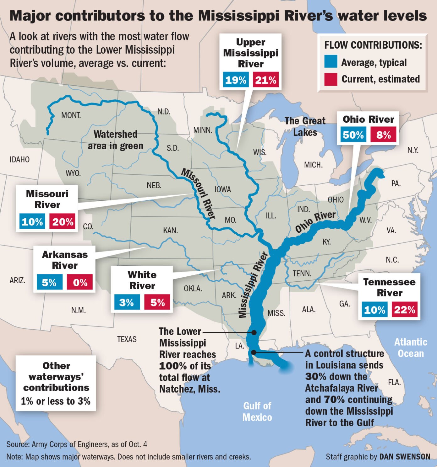
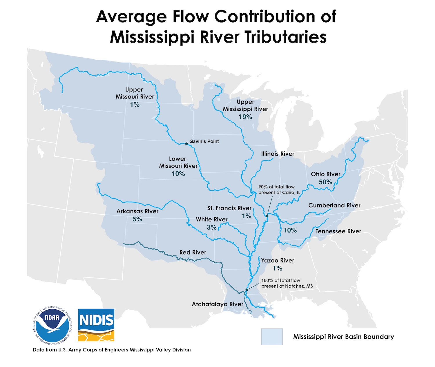
The initial stages of the Mississippi are characterized by a series of rapids and cascades as it tumbles out of the Brainerd Lakes area and begins to broaden. As it meanders through the Upper Midwest, it collects waters from numerous tributaries, most notably the Missouri River and the Ohio River. The confluence with the Missouri River, just north of St. Louis, Missouri, marks a significant point where the river’s volume dramatically increases, solidifying its identity as a great river. The sheer power and volume of water moving south from this point onward are truly astonishing, a testament to the vast watershed it drains.
The Role of Topography and Watershed
The watershed of the Mississippi River is the largest in North America and the fourth largest in the world, encompassing 32 U.S. states and two Canadian provinces. This immense drainage basin means that virtually all water that falls in the central part of the continent eventually makes its way south via the Mississippi. The subtle but persistent gradient of the land ensures that this water flows consistently towards the lowest point, which is the Gulf of Mexico. Any notion of the river flowing north, east, or west is contrary to the fundamental geological and hydrological principles that govern its existence.
Navigating the Mighty Southward Flow
The consistent southward flow of the Mississippi River has profound implications for navigation, commerce, and the development of cities and towns along its course. From early Indigenous trade routes to the steamboat era and modern barge traffic, the river has served as a vital transportation highway. Understanding its directionality is paramount for anyone looking to explore its many facets, whether by boat, cruise ship, or from its scenic banks.
Steamboats and the River’s Highways
The romanticized era of the Mississippi River steamboat would have been impossible without its predictable southward flow. These majestic vessels relied on the current to carry them downstream, using their powerful engines primarily for steering and to combat slower sections or navigate against the flow when necessary. Cities like New Orleans, Memphis, and St. Louis owe their historical and economic prosperity, in large part, to their strategic locations on this southern-flowing waterway. The ease of transporting goods and people downstream facilitated trade and settlement, shaping the cultural and economic landscape of the American heartland.
The Modern Era of River Commerce
Today, the Mississippi River remains a critical artery for commerce. Modern barges, pushed by powerful towboats, transport vast quantities of grain, coal, petroleum products, and other commodities downstream to the export terminals at the Gulf of Mexico. The controlled flow, managed in part by a system of locks and dams, particularly in the upper reaches, ensures navigability year-round. However, the fundamental direction of travel, dictated by gravity, remains unchanged. This southward flow is the engine of a multi-billion dollar industry, connecting inland producers to global markets.
The River’s Delta: A Southern Embrace
The culmination of the Mississippi River’s long journey is its expansive delta region in Louisiana. Here, the river, having slowed considerably as it approaches sea level, deposits the sediment and silt it has carried from thousands of miles upstream. This continuous deposition has, over millennia, created a vast network of distributaries, bayous, and wetlands that form the unique ecosystem of the Mississippi River Delta.
Formation of the Delta
The southward flow is what allows the Mississippi River to build and sustain its delta. As the river enters the relatively still waters of the Gulf of Mexico, its velocity decreases, causing it to drop its load of sediment. This process, known as delta formation, is ongoing, although human intervention through levees and channelization has altered its natural dynamics. The delta itself fans out into the Gulf, a testament to the river’s relentless southward push. Exploring the Louisiana bayous offers a fascinating glimpse into a landscape shaped by this constant, southbound flow, a place where freshwater meets saltwater, and unique cultures have thrived for centuries.
Environmental Significance and Future
The Mississippi River Delta is a vital ecological zone, supporting diverse wildlife and serving as a critical nursery for many marine species. The southward flow is fundamental to its existence, replenishing the land and sustaining the wetlands. However, the delta faces significant challenges, including land subsidence and coastal erosion. Understanding the river’s determined southward path is crucial for appreciating its past, present, and the ongoing efforts to preserve this invaluable natural resource for future generations. The river’s journey from the northern lakes to the southern sea is a continuous, awe-inspiring testament to the power of gravity and the enduring spirit of this American icon.
LifeOutOfTheBox is a participant in the Amazon Services LLC Associates Program, an affiliate advertising program designed to provide a means for sites to earn advertising fees by advertising and linking to Amazon.com. Amazon, the Amazon logo, AmazonSupply, and the AmazonSupply logo are trademarks of Amazon.com, Inc. or its affiliates. As an Amazon Associate we earn affiliate commissions from qualifying purchases.