
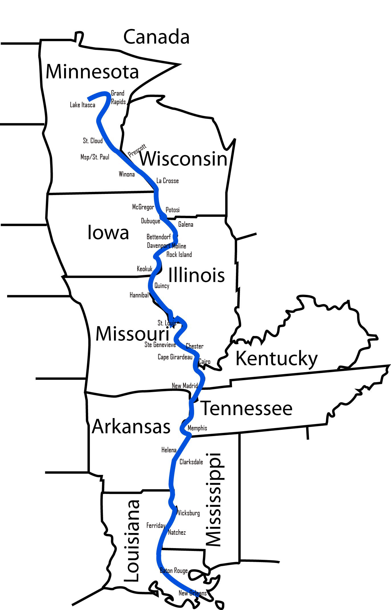
The question “Which way does the Mississippi River run?” is more profound than a simple geographical query; it’s an inquiry into the very soul of North America’s greatest river, a monumental natural landmark that has shaped landscapes, ecosystems, and human civilizations for millennia. Flowing for approximately 2,340 miles (3,766 kilometers) from its humble origins in northern Minnesota to its grand delta on the Gulf of Mexico, the Mississippi River predominantly runs south. This southward trajectory is the defining characteristic of its journey, guiding its vast waters and myriad tributaries across the heartland of the United States towards the ocean. Understanding this fundamental direction is key to appreciating its immense geographical, ecological, historical, and cultural significance as a towering natural landmark.

The Grand Trajectory: From Source to Sea
The Mississippi River’s course is a dynamic and ever-evolving masterpiece of nature, a testament to the powerful forces of water and geology. Its long southward path can be broadly divided into three distinct segments, each with its own character and impact on the surrounding landscape.
The Headwaters: Lake Itasca and Northern Beginnings
The story of the Mississippi River begins in the tranquil waters of Lake Itasca, a relatively small, pristine lake nestled within Itasca State Park in northwestern Minnesota. Here, at an elevation of about 1,475 feet (450 meters) above sea level, a small stream emerges, easily stepped across by visitors, marking the official inception of this colossal waterway. In its initial stages, the river is narrow, shallow, and often characterized by a series of small rapids and riffles, winding through dense forests and wetlands. It is a humble beginning for a river that will eventually become one of the world’s most significant.
The early flow is influenced by glacial meltwaters and precipitation within the local watershed, gradually gaining volume as it collects runoff from countless small creeks and streams. This nascent Mississippi River carves a path through the predominantly flat to gently rolling terrain of northern Minnesota, its initial meanders hinting at the grander serpentine journey ahead. This northern segment, extending for several hundred miles, sets the stage for the river’s consistent southward push, laying the groundwork for the more powerful and expansive stretches to follow. The landscape here is a mosaic of boreal forests, peat bogs, and freshwater lakes, a rich natural environment that cradles the river in its infancy.
Navigating the Upper Mississippi: Meandering South
As the Mississippi River flows further south from its headwaters, it rapidly gains in width and depth, transforming from a babbling stream into a substantial river. This section, generally considered the Upper Mississippi, extends approximately from St. Paul, Minnesota, down to the confluence with the Ohio River near Cairo, Illinois. Throughout this stretch, the river maintains its dominant southward course, albeit with significant and dramatic meanders that define much of its character. It forms borders for, or flows through, ten U.S. states: Minnesota, Wisconsin, Iowa, Illinois, Missouri, Kentucky, Tennessee, Arkansas, Mississippi, and Louisiana.
The Upper Mississippi is renowned for its series of locks and dams, which were constructed to maintain a navigable channel for commercial barge traffic. These engineering marvels create a series of “pools” that transform parts of the river into broader, lake-like expanses, particularly visible in states like Wisconsin and Iowa. The landscape flanking the Upper Mississippi is characterized by bluffs, fertile floodplains, and extensive wetlands, which are crucial habitats for migratory birds and diverse aquatic life. Major cities like Minneapolis and St. Paul in Minnesota, and St. Louis in Missouri, stand as significant urban landmarks along this section, their histories inextricably linked to the river’s commercial and cultural importance. The continuous southward flow here is fundamental to the region’s hydrology, carrying water and sediment steadily towards the ocean.
The Mighty Lower Mississippi: A Powerful Journey
Below the confluence with the Ohio River, which dramatically doubles the Mississippi’s volume, lies the Lower Mississippi. This section, stretching roughly 1,000 miles (1,600 kilometers) to the Gulf of Mexico, is the domain of the truly “Mighty Mississippi.” Here, the river becomes an immense, powerful force, carving a broad, winding path through a vast floodplain that can be tens of miles wide. The deep, often muddy waters carry an enormous sediment load, a geological process that has been shaping the Mississippi Delta for thousands of years. The course remains steadfastly southward, though its meanders become more exaggerated, forming oxbow lakes and creating new land through deposition and erosion.
The Lower Mississippi is largely contained by an extensive system of levees, built to protect the fertile agricultural lands and urban centers within its floodplain from catastrophic floods. Iconic cities like Memphis, Tennessee, and New Orleans, Louisiana, thrive along its banks, their very existence intertwined with the river’s presence. New Orleans, in particular, sits precariously below sea level, protected by elaborate flood control systems that are a testament to the river’s formidable power. The river’s ultimate destination is the Gulf of Mexico, where it discharges an average of 470,000 cubic feet (13,000 cubic meters) of water per second, creating one of the world’s most expansive and ecologically rich deltas. This final leg of its southward journey is where the Mississippi River truly showcases its grandeur, acting as a crucial conduit between the North American continent and the global ocean.
A Geographical and Ecological Marvel
Beyond its directional flow, the Mississippi River stands as a monumental landmark due to its profound influence on the geography and ecology of the North American continent.
Shaping the Continent: Hydrology and Geomorphology
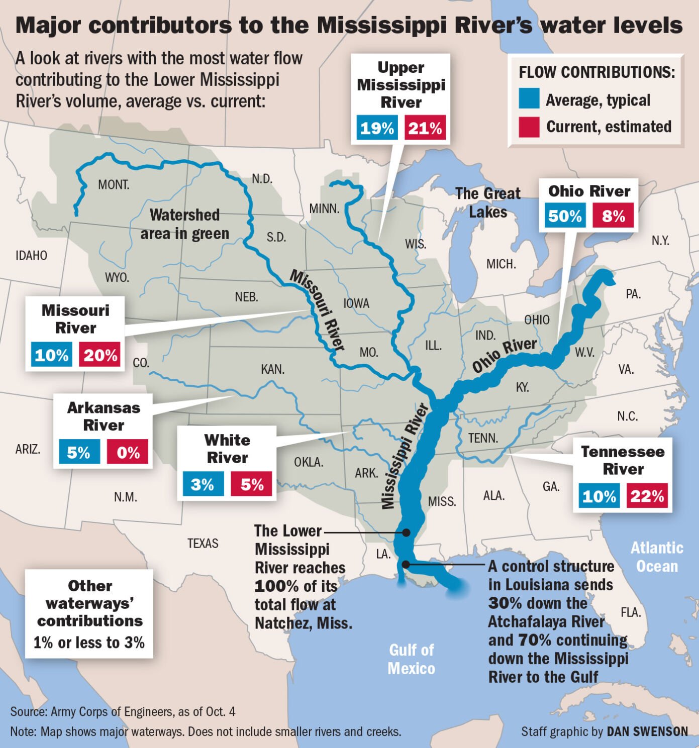
The Mississippi River is the second-longest river in North America and the fourth-longest in the world, but its true claim to fame lies in its enormous watershed. Draining all or parts of 32 U.S. states and two Canadian provinces (though the contribution from Canada is very small), its basin covers over 1.2 million square miles (3.1 million square kilometers), making it the third-largest watershed on Earth. This vast network of tributaries, including major rivers like the Missouri River (its longest tributary) and the Ohio River (its largest by volume), funnels water from the Appalachian Mountains in the east to the Rocky Mountains in the west, all converging into the southward-flowing main stem.
Geomorphologically, the river is a dynamic force of nature. Over millennia, it has carved out and continually reshaped the vast central plains of the United States. Its massive sediment load—estimated at 400 million tons annually—has built the fertile Mississippi Alluvial Plain and the sprawling Mississippi River Delta. These geological features are not static; the river frequently shifts its course within its floodplain, a process known as avulsion, creating new channels and abandoning old ones, leaving behind oxbow lakes and natural levees. Understanding the river’s southward flow is fundamental to understanding these geological processes, as gravity continuously pulls water and sediment towards the Gulf of Mexico, literally building new land and shaping the continent’s southern edge.
A Corridor of Biodiversity: Ecosystems Along the Banks
The Mississippi River’s consistent southward flow creates a crucial ecological corridor, supporting an astonishing diversity of life across various climatic zones. From the boreal forests of Minnesota to the subtropical wetlands of Louisiana, the river system acts as a biological highway. Its floodplains, backwaters, and wetlands are incredibly productive ecosystems, serving as critical habitats for numerous species.
The river supports over 260 species of fish, including paddlefish, sturgeon, and catfish, making it one of the most biodiverse freshwater systems in North America. Its extensive wetlands and flyways are vital for migratory birds, with over 325 species relying on the Mississippi River Flyway during their annual journeys. Mammals like deer, beaver, and otter thrive along its banks, while reptiles and amphibians, including alligators in the southern reaches, add to the rich tapestry of life. The forests, prairies, and marshes sustained by the river’s waters are unique biological landmarks themselves, underscoring the Mississippi’s role as a natural heritage site of unparalleled importance.
The Mississippi: A Ribbon of American History and Culture
As a landmark, the Mississippi River is not merely a geographical feature; it is a profound historical and cultural icon, deeply embedded in the identity of the United States.
Historical Significance: Exploration and Expansion
The river’s southward flow dictated much of its historical significance. For thousands of years, indigenous peoples like the Choctaw, Chickasaw, and Natchez nations lived along its banks, utilizing its waters for sustenance, transportation, and trade. Their ancient mound-building cultures, particularly at sites like Cahokia Mounds near St. Louis, testify to sophisticated societies that flourished due to the river’s bounty.
European exploration of the Mississippi River also followed its southward course. Hernando de Soto was the first documented European to reach the river in 1541, but it was the French explorers Louis Joliet and Jacques Marquette who, in 1673, extensively navigated its upper and middle sections, mapping its southward trajectory and establishing French claims to the vast Louisiana Territory. Later, Robert Cavelier de La Salle famously traveled all the way to the Gulf of Mexico in 1682, cementing the river’s role as a primary artery for exploration and expansion in North America. The river served as a natural boundary, a conduit for migration, and a stage for pivotal historical events, including parts of the American Civil War, especially around places like Vicksburg National Military Park.
Economic Lifeline: Trade and Transportation
For centuries, the Mississippi River’s southward flow made it an indispensable economic lifeline. Early explorers and settlers quickly recognized its potential as a transportation corridor, connecting the interior of the continent to the global trade routes of the Gulf of Mexico. The advent of the steamboat era in the 19th century transformed the river into a bustling highway of commerce, facilitating the movement of agricultural products, timber, and manufactured goods. Towns and cities along its banks, from St. Louis to New Orleans, boomed as port cities.
Today, the Mississippi River remains a critical artery for the United States economy. Its navigable channel, managed by a system of locks and dams, allows barges to transport vast quantities of bulk goods such as grain, coal, petroleum, and chemicals. The annual economic impact of navigation on the river is estimated in the tens of billions of dollars, underscoring its enduring role as a working landmark that sustains industries and communities across the nation.
Cultural Icon: Literature, Music, and Identity
The Mississippi River’s majestic scale and historical importance have cemented its place as a profound cultural icon. It has served as an endless source of inspiration for American literature, perhaps most famously in the works of Mark Twain, whose novels like The Adventures of Tom Sawyer and Adventures of Huckleberry Finn vividly capture the spirit and life along its banks in the 19th century. The river also plays a central role in American music, particularly the blues, which originated in the Mississippi Delta and spread northward, influencing countless genres.
The Mississippi River embodies a unique regional identity, a blend of Southern charm, Midwestern resilience, and frontier spirit. It represents freedom, opportunity, and the untamed wilderness. Its floods and triumphs, its beauty and power, are woven into the collective consciousness of the United States, making it a living landmark that transcends mere geography.
Experiencing the Landmark: A Journey of Discovery
The Mississippi River offers countless opportunities to understand and appreciate its status as an enduring natural landmark.
Preserving the Legacy: Conservation Efforts
Recognizing the immense value of the Mississippi River as a natural and cultural landmark, extensive conservation efforts are underway to protect its ecosystems and heritage. Organizations and government agencies work to manage its water quality, restore wetlands, protect endangered species, and maintain the integrity of its floodplains. Balancing the needs of navigation, agriculture, urban development, and ecological preservation is a complex but vital task, ensuring that future generations can continue to appreciate this mighty river.
Viewing the River: Key Vantage Points and Interpretive Sites
To truly grasp the magnitude of the Mississippi River, one must experience it firsthand from key vantage points and interpretive sites along its southward course. In St. Louis, the Gateway Arch National Park provides an iconic backdrop to the river, symbolizing the westward expansion it facilitated. The riverfronts of cities like Memphis and New Orleans offer historical parks and walkways that reveal its commercial vitality and deep cultural roots. In Vicksburg, Mississippi, the Vicksburg National Military Park overlooks the river, providing profound insights into its strategic importance during the Civil War.
Further north, numerous state parks and wildlife refuges, particularly along the Upper Mississippi River National Wildlife and Fish Refuge, offer opportunities to observe its diverse ecosystems and geological features. Visitors can trace its origins at Itasca State Park, marveling at its modest beginnings. These sites are not merely tourist destinations; they are educational landmarks that allow for a deeper understanding of how the river’s ceaseless southward flow has shaped both the natural world and human history.
An Enduring American Landmark
The answer to “Which way does the Mississippi River run?” is definitively south, but the implications of that simple direction are anything but simple. This river is more than just a hydrological feature; it is a monumental natural landmark that defines the geography, ecology, history, and culture of the United States. From its unassuming source in Minnesota to its grand convergence with the Gulf of Mexico, the Mississippi River carves a path through the continent, carrying not just water and sediment, but also the stories of exploration, commerce, conflict, and artistic inspiration. Its enduring power and beauty continue to fascinate and inspire, making it an irreplaceable American treasure and a globally recognized natural wonder.
LifeOutOfTheBox is a participant in the Amazon Services LLC Associates Program, an affiliate advertising program designed to provide a means for sites to earn advertising fees by advertising and linking to Amazon.com. Amazon, the Amazon logo, AmazonSupply, and the AmazonSupply logo are trademarks of Amazon.com, Inc. or its affiliates. As an Amazon Associate we earn affiliate commissions from qualifying purchases.