
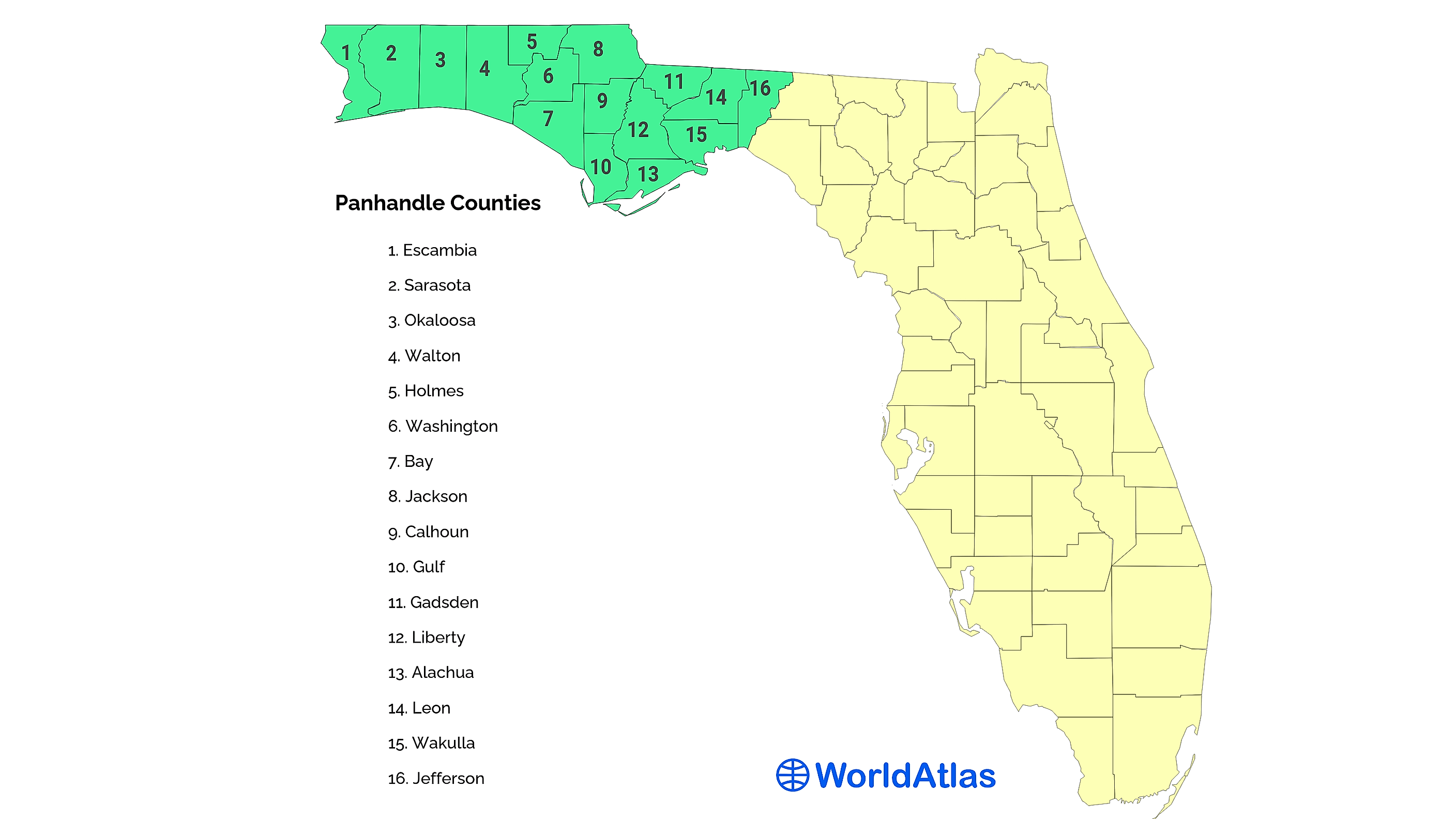
The geography of the United States is replete with descriptive nicknames, but few are as visually intuitive as the Florida Panhandle. When looking at a map of North America, the state of Florida resembles a long, narrow peninsula reaching toward the Caribbean Sea. However, the northwestern portion of the state juts out to the west, creating a rectangular strip of land that connects the peninsula to the rest of the mainland. This specific shape—a long, thin projection attached to a larger “body”—closely mirrors the handle of a frying pan, leading to the ubiquitous moniker that has defined the region for over a century.

Beyond the simple visual metaphor, the Florida Panhandle represents a distinct intersection of history, geology, and culture. While the rest of Florida is often associated with tropical climates and the Atlantic Ocean, the Panhandle shares more in common with the Deep South, bordering Alabama to the north and west and Georgia to the north. Understanding why this region exists as a separate geographic entity requires a look at the colonial disputes and natural landmarks that shaped the map we see today.
The Geographic Origin of the Name
The term “panhandle” is a generic geographic descriptor used to describe any long, narrow arm of a territory. In the United States, several states possess these features, including Texas, Oklahoma, and West Virginia. However, the Florida Panhandle is perhaps the most famous due to its significant length and the way it hugs the Gulf of Mexico.
The Visual Metaphor
The “panhandle” designation is purely informal but highly practical. The peninsula of Florida acts as the “bowl” of the pan, while the approximately 200-mile stretch of land extending westward forms the “handle.” This region typically encompasses the area west of the Aucilla River, though some definitions begin at the Suwannee River. The strip is roughly 50 to 100 miles wide, squeezed between the Gulf of Mexico and the southern borders of Alabama and Georgia.
Defining the Borders
The northern boundary of the Panhandle is a straight line following the 31st parallel north, a border established through various treaties during the colonial era. To the west, the Perdido River serves as the natural boundary between Florida and Alabama. This narrow corridor provides the state with an extensive coastline along the Gulf Coast, distinct from the marshy or coral-heavy shores found further south in the Florida Keys or the Everglades.
Historical Significance and the Two Floridas
The reason Florida has a panhandle at all is rooted in the 18th-century administrative divisions of Spain and Great Britain. During different periods of colonial rule, the territory was not managed as a single entity but was split into two separate provinces: East Florida and West Florida.
British and Spanish Influence
When Great Britain took control of the region in 1763 following the Seven Years’ War, they found the territory too large to govern from a single location. Consequently, they divided it at the Apalachicola River. East Florida, with its capital at St. Augustine, covered the peninsula. West Florida, with its capital at Pensacola, covered the region that we now call the Panhandle, and originally extended all the way to the Mississippi River.
When Spain regained the territories in 1783, they maintained this two-province system. It wasn’t until the United States acquired the land that the idea of a unified Florida began to take shape.
The Adams-Onis Treaty
Under the Adams-Onis Treaty of 1819, Spain ceded all of Florida to the United States. In 1822, the U.S. Congress merged East Florida and West Florida into a single territory. To bridge the gap between the two former capitals, Tallahassee was chosen as the new capital in 1824, situated roughly halfway between St. Augustine and Pensacola. While the western reaches of the original West Florida were eventually absorbed by Louisiana, Mississippi, and Alabama, the section remaining under Floridian control became the “handle” of the state.
Natural Landmarks of the Panhandle

The Florida Panhandle is home to some of the most unique geographic landmarks in the country. Its natural beauty is defined by high bluffs, deep river valleys, and coastal formations that are entirely different from the flat, limestone-based terrain of the southern peninsula.
The Emerald Coast and White Quartz Sands
One of the most famous landmarks in the region is the Emerald Coast, a stretch of shoreline including Destin, Fort Walton Beach, and Panama City Beach. The landmark feature here is the sand. Unlike the shell-based sands of southern Florida, the Panhandle features sand made of nearly pure, weathered quartz that washed down from the Appalachian Mountains millions of years ago. This creates a brilliant white surface that stays cool to the touch even in the summer heat.
The Forgotten Coast and River Systems
Moving east, one encounters the Forgotten Coast, a quiet, undeveloped stretch of coastline that includes landmarks like Apalachicola Bay and St. George Island. This area is defined by the Apalachicola River, a massive freshwater system that feeds the bay and supports one of the most productive oyster beds in the United States. The river itself is a landmark of biodiversity, carving through the hills of the northern Panhandle and creating rare steep-head ravines.
Historic Architecture and Military Landmarks
The Florida Panhandle is not just a geological curiosity; it is a repository of some of the oldest colonial and military landmarks in North America.
Pensacola: The City of Five Flags
Pensacola is a primary landmark of the region, often called the “City of Five Flags” because it has been under the rule of Spain, France, Great Britain, the Confederate States of America, and the United States. The city’s historic district is a landmark of colonial architecture, blending Spanish and British styles. Nearby, the National Naval Aviation Museum serves as a modern landmark, celebrating the city’s role as the “Cradle of Naval Aviation.”
Coastal Defense and Fort Pickens
Located on Santa Rosa Island, Fort Pickens is a massive pentagonal brick fortification completed in 1834. It is one of the few Union forts in the South that was never captured by Confederate forces during the American Civil War. As part of the Gulf Islands National Seashore, this landmark offers a window into 19th-century military engineering and the strategic importance of the Panhandle coastline.
Another vital maritime landmark is the St. Marks Lighthouse. Built in 1831 at the mouth of the St. Marks River, it is the second-oldest lighthouse in Florida and has survived numerous hurricanes and the Civil War.
The Environmental Legacy of the Region
The Florida Panhandle is frequently recognized for its ecological landmarks, which differ significantly from the tropical ecosystems found in Miami or the Florida Keys.
State Parks and Ecological Preserves
The region is home to an array of protected lands that serve as natural landmarks. Grayton Beach State Park is frequently ranked as one of the most beautiful beaches in the country, but it is also famous for its rare coastal dune lakes. These lakes, which contain a mix of fresh and salt water, are found in only a few places worldwide, including Madagascar and Australia.
Further west, Henderson Beach State Park in Destin preserves the last remaining coastal scrub forest in the area, providing a stark contrast to the surrounding high-rise developments. These parks act as landmarks of conservation, protecting the Florida Panhandle from the rapid urbanization seen in other parts of the state.
Wakulla Springs and the Deep Earth
South of Tallahassee lies Edward Ball Wakulla Springs State Park, home to Wakulla Springs. This is one of the world’s largest and deepest freshwater springs. The landmark is famous not only for its clear waters and manatees but also for its role in Hollywood history; several “Tarzan” movies and the “Creature from the Black Lagoon” were filmed here. The spring is the gateway to a massive underwater cave system, a geological landmark that remains one of the most explored yet mysterious subterranean environments in North America.
In conclusion, the Florida Panhandle is called such because of a simple visual resemblance to a kitchen utensil, but the region itself is a complex tapestry of landmarks. From the historic fortifications of Pensacola to the quartz sands of the Emerald Coast, and from the legislative halls of Tallahassee to the ancient depths of Wakulla Springs, the “handle” of Florida holds much of the state’s most profound historical and natural wealth. It remains a distinct geographic and cultural landmark, bridging the gap between the American South and the unique subtropical world of the Florida peninsula.
LifeOutOfTheBox is a participant in the Amazon Services LLC Associates Program, an affiliate advertising program designed to provide a means for sites to earn advertising fees by advertising and linking to Amazon.com. Amazon, the Amazon logo, AmazonSupply, and the AmazonSupply logo are trademarks of Amazon.com, Inc. or its affiliates. As an Amazon Associate we earn affiliate commissions from qualifying purchases.