
The Florida Panhandle, a distinctive sliver of land stretching westward from the main peninsula of Florida, boasts a name that is as straightforward as it is descriptive. Unlike many geographical designations steeped in ancient lore or named after colonial figures, the “Panhandle” moniker instantly evokes an image of its unique shape. This region, a vibrant mosaic of history, natural beauty, and cultural identity, acquired its name due to its striking resemblance to the handle of a cooking pan, attached to the broader ‘body’ of the state. Its identity is deeply intertwined with this geographical reality, shaped by centuries of historical shifts and defined by its remarkable natural landmarks.

The Geographical Reality: A Distinctive Shape
The very essence of the Florida Panhandle’s name lies in its unmistakable physical appearance. It is a testament to the power of simple, descriptive language to capture the essence of a geographical feature. This region’s long, narrow extension westward is what visually sets it apart and gives rise to its familiar designation.
Visualizing the Panhandle
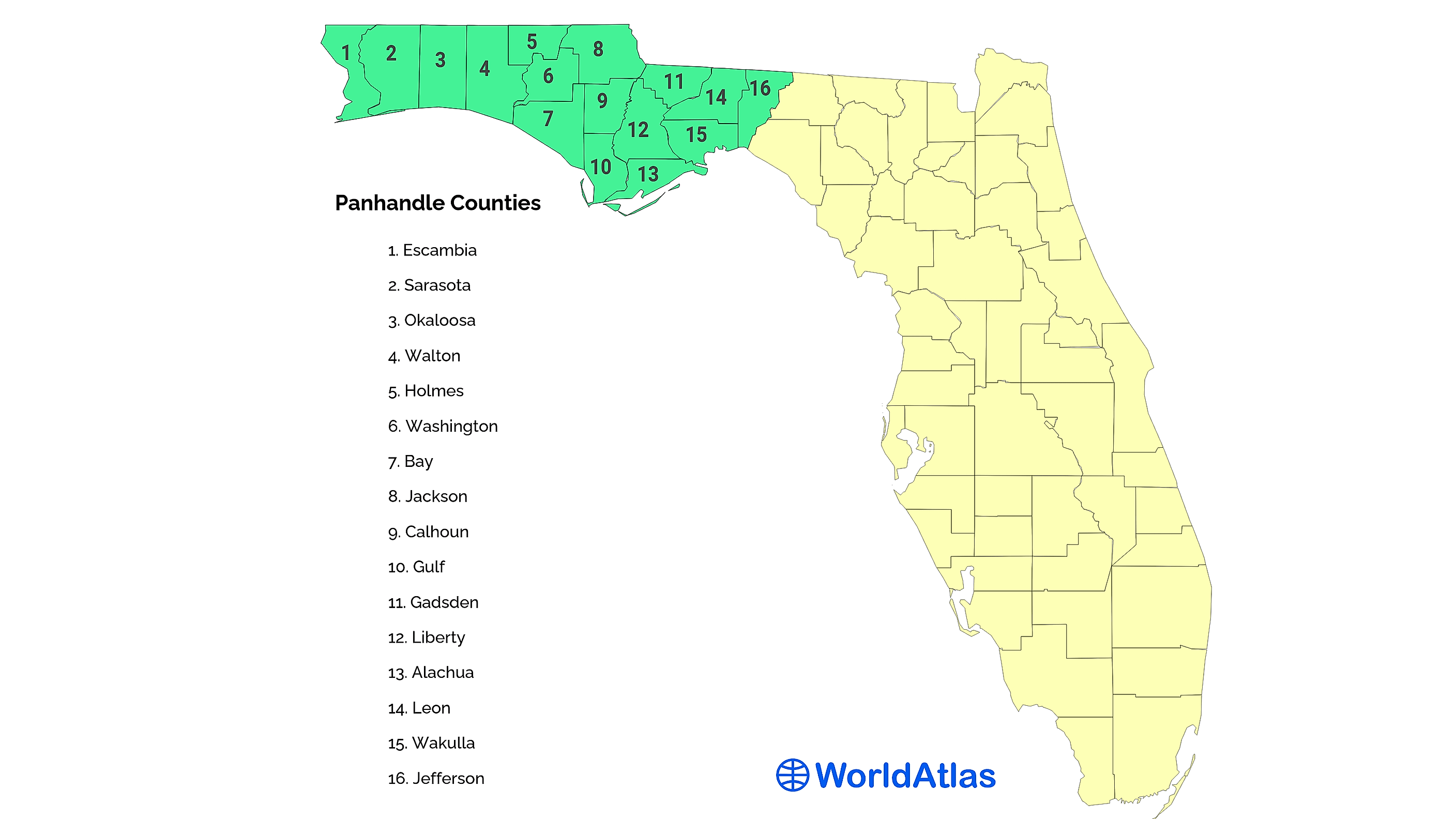
To understand the name, one only needs to glance at a map of Florida. The main body of the state forms a broad peninsula, thrusting southward between the Atlantic Ocean and the Gulf of Mexico. However, in its northwestern quadrant, a distinct, elongated strip of land juts out horizontally, extending for approximately 200 miles. This protrusion is flanked by the borders of Alabama and Georgia to its north, and the warm, emerald waters of the Gulf of Mexico to its south. The visual metaphor is immediate and undeniable: the main peninsula of Florida serves as the ‘pan,’ and this extended western arm functions as its ‘handle.’ This visual analogy is not merely coincidental but an accurate representation of how the region is perceived and understood, making the name both intuitive and enduring. The gentle arc of the coastline, often referred to as the “Emerald Coast” for its distinctive water color, further defines the southern edge of this handle, contrasting with the more rectilinear northern border.
Beyond the Metaphor: Defining the Region
While the panhandle shape is the defining characteristic, the region itself is a complex and diverse area encompassing several counties and distinct ecological zones. Geographically, the Panhandle is generally understood to include the westernmost counties of Florida, from Escambia County in the west (home to Pensacola) eastward to counties like Franklin, Liberty, and even Wakulla County, near the state capital of Tallahassee. Some broader definitions extend its eastern boundary further to the Suwannee River.
Within these boundaries, the Panhandle presents a rich tapestry of landscapes. Along its southern edge, the iconic white-sand beaches, composed of nearly pure quartz crystal, meet the Gulf. Inland, the terrain transitions into vast pine forests, cypress swamps, and fertile agricultural lands. The geological history of the region, characterized by ancient marine deposits and fluctuating sea levels, has sculpted unique features such as rare coastal dune lakes, expansive estuarine systems, and the underlying porous limestone that feeds numerous freshwater springs. These natural elements contribute to a distinct regional character, further differentiating the Panhandle from the central and southern parts of the state.
Historical Roots: A Legacy of Shifting Borders
The unique shape of the Florida Panhandle is not merely an accident of nature but a fascinating outcome of centuries of geopolitical maneuvering, colonial ambition, and territorial demarcation. Its history is a compelling narrative of how maps were drawn and redrawn, ultimately solidifying the boundaries that define it today.
Colonial Contests and Territorial Claims
The origins of Florida’s distinctive shape, including its prominent panhandle, can be traced back to the complex colonial history of North America. For centuries, the territory now known as Florida was a contested prize, coveted by Spain, France, and Great Britain. Each imperial power sought to establish and defend its claims, leading to fluid borders and often contradictory maps.
A pivotal moment occurred in 1763, following the conclusion of the French and Indian War (known globally as the Seven Years’ War). Under the terms of the Treaty of Paris (1763), Spain ceded Florida to Great Britain. The British, for administrative purposes, divided the vast territory into two separate colonies: East Florida and West Florida. East Florida encompassed the majority of the peninsula, with its capital at St. Augustine. West Florida, on the other hand, was a much longer and narrower strip of land. It stretched westward from the Apalachicola River all the way to the Mississippi River, encompassing not only the modern Florida Panhandle but also parts of what are now Alabama, Mississippi, and Louisiana. Its capital was Pensacola. This elongated configuration of West Florida was the earliest governmental manifestation of a “panhandle” shape, albeit one that was significantly larger than what exists today.
American Acquisition and Statehood
The trajectory of the Florida Panhandle’s shape continued through the American Revolution and its aftermath. While the United States gained independence, Florida reverted to Spanish control in 1783. However, Spanish hold was tenuous, and the new American republic had strong expansionist ambitions, particularly concerning access to the Gulf Coast and the mouth of the Mississippi River.
The final shape of the Florida Panhandle was largely cemented with the Adams-Onís Treaty of 1819 (ratified in 1821). In this landmark agreement, Spain formally ceded all of Florida to the United States. Crucially, by this time, the boundaries of the present-day Panhandle had already been set. The parts of the original British West Florida that lay west of the Perdido River (which forms Florida’s western boundary) had been absorbed into Alabama and Mississippi as those territories were organized. Thus, when Florida officially became a U.S. territory in 1821 and subsequently a state in 1845, its western boundary was fixed at the Perdido River, creating the distinct, narrow extension we recognize today. The historical evolution of these borders, driven by strategic interests and diplomatic negotiations, directly led to the “panhandle” shape being etched into the map of the United States.
A Region of Distinctive Landmarks and Natural Wonders
Beyond its fascinating etymology and historical development, the Florida Panhandle is a region rich in significant landmarks and unparalleled natural beauty. These features not only define the character of the Panhandle but also serve as testament to its unique place within Florida’s diverse landscape.
Iconic Coastal Features
The most famous landmarks of the Florida Panhandle are undoubtedly its stunning beaches. Renowned globally for their sugary white sand, which is actually finely ground quartz crystals reflecting sunlight, and the clear, emerald-green waters of the Gulf of Mexico, these coastal stretches are a defining characteristic. Cities and towns like Destin, Panama City Beach, Fort Walton Beach, Pensacola Beach, and the scenic communities along Highway 30A (such as Seaside and Rosemary Beach) are celebrated for their natural allure. These areas also feature rare coastal dune lakes, a geological phenomenon found in only a handful of places worldwide, adding to the ecological distinctiveness of the coastline. These lakes, shallow and often brackish, occasionally breach the dunes to connect with the Gulf, creating unique ecosystems that support diverse flora and fauna.
Historical and Cultural Landmarks
The Panhandle is also steeped in history, offering a wealth of cultural landmarks that tell the story of Florida’s past. Pensacola, often referred to as “America’s First City,” holds the distinction of being the first European settlement in the United States (established 1559, though not continuously occupied, making St. Augustine the oldest continuously inhabited). Its historic downtown, Palafox Street, and sites like Fort Barrancas and the National Naval Aviation Museum at Naval Air Station Pensacola offer deep insights into centuries of military and civilian life.
Further east, Tallahassee, the state capital, sits firmly within the Panhandle, serving as a political and cultural hub. Its landmarks include the historic and modern Florida State Capitol Buildings, the beautiful grounds of Alfred B. Maclay Gardens State Park, and its two major universities, Florida State University and Florida A&M University. Military installations throughout the region, such as Eglin Air Force Base, are significant modern landmarks that contribute to the region’s economy and identity.
Natural Preserves and Ecosystems
Beyond the beaches and historic cities, the Florida Panhandle is home to vast stretches of pristine wilderness and crucial ecosystems. Large tracts of land are protected within state parks and national forests, preserving Florida’s unique biodiversity. The Apalachicola National Forest, the largest national forest in Florida, covers over 570,000 acres and is renowned for its longleaf pine forests, wetlands, and diverse wildlife, including the endangered red-cockaded woodpecker. The Blackwater River State Forest offers opportunities for kayaking and canoeing on its namesake river, known for its distinctive dark, tannin-stained waters. These natural landmarks underscore the Panhandle’s commitment to conservation and provide crucial habitats, contrasting sharply with the developed coastal areas.
The Panhandle’s Enduring Identity
The name “Panhandle” is more than just a label; it has become an integral part of the region’s identity, shaping perceptions and fostering a distinct sense of place. It perfectly encapsulates the geographical truth of the area and symbolizes its unique characteristics.
More Than Just a Name
The simplicity and descriptive power of the name “Panhandle” have allowed it to seamlessly integrate into the regional lexicon, understood by residents and visitors alike. It is a geographically accurate and instantly recognizable identifier that distinguishes this western extension from the rest of Florida. This distinct geography has, in turn, fostered a unique cultural identity for the Panhandle. Often referred to as “Northwest Florida” or “Upper Florida,” the region shares cultural affinities with its northern neighbors, Alabama and Georgia, in ways that differ significantly from central or south Florida. This distinction is evident in its cuisine, accents, architecture, and even its political leanings, creating a fascinating blend of Southern charm and quintessential Florida coastal living. The name, therefore, is not just a geographical descriptor but a shorthand for a whole distinct sub-region within the state.

A Recognizable Emblem
Today, the Florida Panhandle is a well-established and highly recognized name, synonymous with stunning white-sand beaches, emerald waters, rich history, and expansive natural landscapes. From the historic streets of Pensacola to the vibrant shores of Panama City Beach, and the serene forests of the Apalachicola National Forest, the name evokes a clear picture for millions. It is a testament to the power of a simple, descriptive moniker that perfectly captures the physical reality and enduring spirit of a remarkable corner of the United States. The “Panhandle” will undoubtedly continue to be the beloved and appropriate designation for this iconic stretch of Florida for generations to come.
LifeOutOfTheBox is a participant in the Amazon Services LLC Associates Program, an affiliate advertising program designed to provide a means for sites to earn advertising fees by advertising and linking to Amazon.com. Amazon, the Amazon logo, AmazonSupply, and the AmazonSupply logo are trademarks of Amazon.com, Inc. or its affiliates. As an Amazon Associate we earn affiliate commissions from qualifying purchases.