
The image of California crumbling into the Pacific Ocean is a dramatic and persistent fixture in popular culture, fueled by disaster movies and a general fascination with the state’s active geology. From the iconic cliffs of Big Sur to the bustling urban sprawl of Los Angeles and San Francisco, the Golden State is renowned for its diverse landscapes, many of which owe their very existence to the powerful, underlying forces of plate tectonics. This article delves into the scientific realities behind the myth, exploring how California’s geological dynamism shapes its most famous landmarks and natural wonders, rather than signaling their imminent demise. Far from sinking, California is a vibrant testament to the Earth’s continuous, slow-motion ballet of creation and transformation, a land where nature’s raw power is permanently on display, sculpting landscapes that continue to captivate visitors and residents alike.
The Enduring Myth of a Sinking California
The notion that a massive earthquake could one day cleave California from the North American continent, sending it plunging into the ocean, is deeply ingrained in the public imagination. This catastrophic vision has been perpetuated for decades, often overshadowing the complex and fascinating scientific reality of the state’s geological makeup. While seismic activity is an undeniable aspect of life in California, the dramatic imagery of an entire state disappearing under the waves is purely mythical, lacking any scientific basis.
Geological Realities vs. Popular Imagination
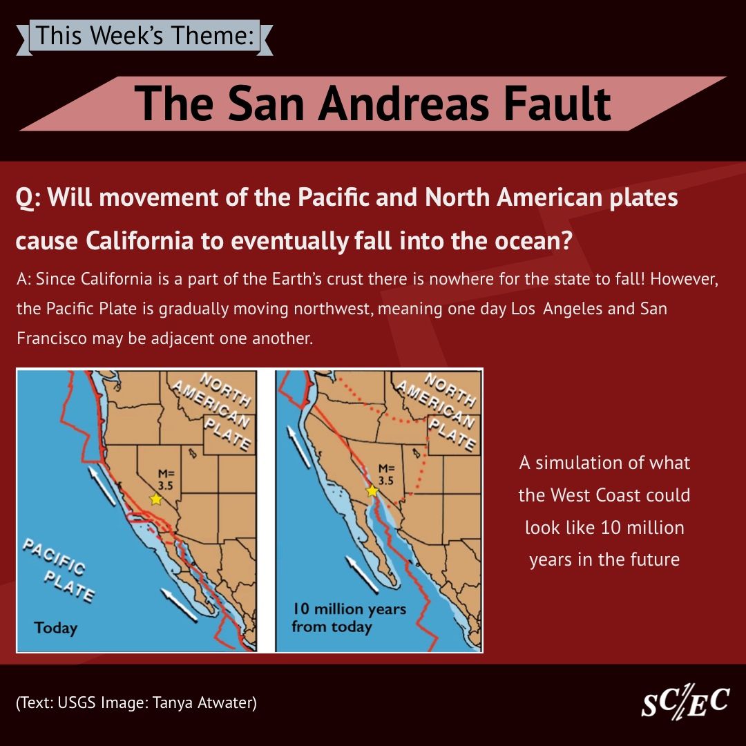
At its core, the myth stems from a misunderstanding of plate tectonics, specifically the interaction between the Pacific Plate and the North American Plate. These two colossal segments of the Earth’s crust meet along the famous San Andreas Fault, a transform fault where they slide horizontally past each other, rather than colliding or pulling apart vertically. Earthquakes occur when the immense stress built up along this fault is suddenly released, causing the ground to shake. However, this lateral movement does not involve large sections of land breaking off and subsiding into the ocean. Instead, it leads to the gradual shifting and deformation of the crust over millions of years, slowly reshaping the landscape and creating the very landmarks we admire today. The mountains, valleys, and coastal formations are products of these enduring forces, not victims awaiting collapse.
Hollywood and the Disaster Narrative
The film industry, particularly Hollywood, has played a significant role in cementing the “sinking California” narrative. Movies like “San Andreas” depict hyper-realistic, albeit scientifically inaccurate, scenarios of the state being torn apart and submerged by mega-tsunamis and catastrophic seismic events. While these films offer thrilling entertainment, they contribute to a widespread misconception that overlooks the nuanced geological processes at play. The dramatic visual spectacle often takes precedence over scientific accuracy, feeding into anxieties about natural disasters and creating a powerful, albeit false, image of California’s vulnerability. This cultural imprint makes it challenging to convey the actual, more gradual and less dramatic, geological transformations that define the state.
Understanding California’s Dynamic Geology
To truly appreciate California’s natural landmarks, one must first grasp the powerful geological forces that have sculpted them over millennia. The state is a geological marvel, sitting at the fiery intersection of two major tectonic plates, making it one of the most seismically active regions on Earth. This constant movement is not a threat to California’s existence but rather the very engine of its breathtaking natural diversity.
The San Andreas Fault and Plate Tectonics
The San Andreas Fault is arguably California’s most famous geological feature, a vast network of fractures in the Earth’s crust that stretches approximately 800 miles through the state. It marks the boundary between the Pacific Plate to the west and the North American Plate to the east. These plates are not stationary; the Pacific Plate is grinding northwestward relative to the North American Plate at an average rate of about 2 inches (5 centimeters) per year. This movement is similar to rubbing your hands together – sometimes they slide smoothly, and other times they catch, building up pressure until they suddenly slip. It is these “slips” that we experience as earthquakes. Over millions of years, this lateral motion has not caused land to fall into the ocean, but rather has dragged parts of California northward, creating mountain ranges, valleys, and basins in its wake. The peninsula of Point Reyes, for instance, has moved nearly 300 miles north relative to Los Angeles over the past 15-20 million years due to this very process.
A Land Forged by Tremors: Earthquakes as a Natural Phenomenon
Earthquakes are an inherent and essential part of California’s geological evolution. While they can be destructive, they are also a natural force of creation, shaping the very topography that defines the state. The seismic activity along the San Andreas Fault and its many subsidiary faults has uplifted mountain ranges like the Sierra Nevada, carved out the immense Central Valley, and contributed to the rugged beauty of the coastal areas. Without these tremors, California would be a vastly different, likely much flatter, landscape. Scientists continuously monitor seismic activity, not to predict the “big one” that will sink the state, but to understand the forces at play and help communities build resilience. The slow, inexorable march of plate tectonics ensures that California is in a constant state of geological flux, perpetually being reshaped, but always remaining a part of the North American continent.
Iconic Landmarks Shaped by Earth’s Forces
The very forces that fuel the myth of California sinking are, in reality, the architects of its most celebrated natural and man-made landmarks. From dramatic coastlines to towering mountain ranges, the state’s geology has profoundly influenced where people live, what they build, and what natural wonders they can explore.
Coastal Wonders: From Big Sur to La Jolla

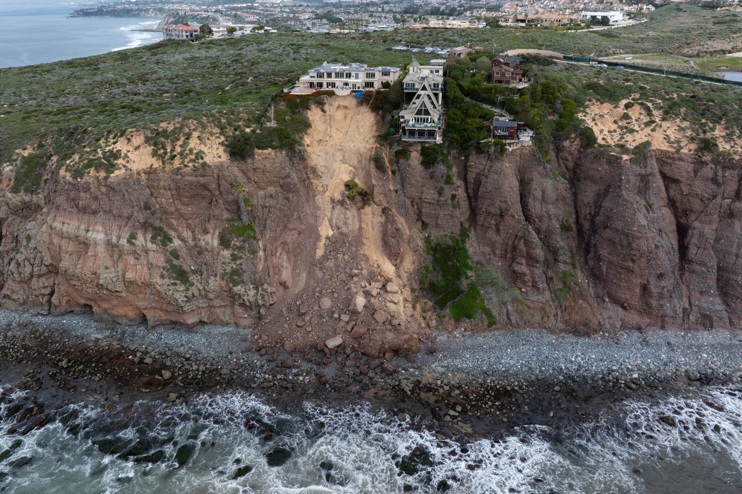
California’s coastline is a masterpiece of geological artistry, with formations that directly reflect the interplay between land, sea, and tectonic activity. The dramatic cliffs and sea stacks of Big Sur, for instance, are the result of uplift caused by tectonic forces, followed by relentless erosion from the Pacific Ocean. Here, the coastal mountains rise directly from the sea, creating breathtaking vistas and challenging terrain that attracts millions. Further south, the sea caves and rugged shorelines of La Jolla are also carved from uplifted sedimentary rock, testament to the ongoing geological processes. While coastal erosion is a natural and continuous process, it’s a gradual reshaping, not a sudden collapse of the entire landmass. These areas are not falling into the ocean but are instead continually sculpted by the very forces that define them, creating a dynamic and ever-evolving natural panorama.
Mountain Ranges and Valleys: The Sierra Nevada and the Central Valley
Inland, California’s topography is equally dramatic. The majestic Sierra Nevada mountain range, home to natural wonders like Yosemite National Park and the highest peak in the contiguous United States, Mount Whitney, is a classic example of fault-block mountains. These granite titans were primarily formed by massive uplift along fault lines on their eastern flank, with the entire block tilting westward over millions of years. This process created the steep eastern escarpment and the more gradual western slope, shaping the drainage patterns and the ecosystems found within. To the west of the Sierras lies the vast, fertile Central Valley, a massive sedimentary basin formed by the down-dropping of the Earth’s crust between the uplifted coastal ranges and the Sierra Nevada. This geological cradle is California’s agricultural heartland, a testament to the diverse environments created by tectonic activity. Even the arid expanse of the Mojave Desert and Death Valley to the southeast display features born of faulting and subsidence, creating unique landscapes of stark beauty and geological intrigue.
Urban Landscapes on Tectonic Plates: Los Angeles and San Francisco
California’s major urban centers are also inextricably linked to its geology. San Francisco, famously built on hills and surrounding the iconic Golden Gate Bridge, sits precariously close to the main trace of the San Andreas Fault, which runs just offshore. The city’s topography, including its famous hills, is a direct result of compressive forces and uplift along numerous smaller faults that crisscross the Bay Area. Similarly, Los Angeles is a sprawling metropolis built across a complex network of faults, including the Puente Hills Thrust Fault and the Hollywood Fault. The basin and range topography of Southern California with its numerous mountain ranges like the Santa Monica Mountains and the San Gabriel Mountains is a product of these very tectonic interactions. While living in these areas requires a constant awareness of seismic risk, engineers and urban planners have developed sophisticated building codes and infrastructure resilience measures to withstand earthquakes, ensuring the continuity of these vibrant cities amidst the dynamic geological backdrop. The very fabric of these urban landmarks is a testament to humanity’s ability to adapt and thrive on a restless planet.
Adapting to a Geologically Active Landscape
Living in California means coexisting with a dynamic Earth. Far from fearing its geological activity, residents and authorities have developed sophisticated strategies to adapt, turning potential vulnerabilities into areas of expertise and resilience. This adaptation is evident in everything from stringent building codes to innovative conservation efforts.
Engineering Resilience: Building for Earthquakes
The perceived threat of earthquakes has driven California to become a global leader in seismic engineering. Building codes are among the strictest in the world, mandating designs that allow structures to sway and absorb seismic energy rather than rigidly resist and fracture. Landmarks like the Golden Gate Bridge have undergone extensive retrofitting to enhance their earthquake resistance, ensuring their stability for future generations. Skyscrapers in Los Angeles and San Francisco are designed with sophisticated dampening systems and flexible foundations. Homes are bolted to their foundations, and utilities are designed to flex with ground movement. This commitment to engineering resilience means that while earthquakes are inevitable, catastrophic structural failures are significantly mitigated, allowing California’s urban landmarks to stand tall and safely accommodate millions.
Conservation and Coastal Management: Protecting California’s Edge
Beyond urban centers, geological awareness informs critical environmental conservation and coastal management practices. Organizations and government agencies work tirelessly to understand and manage coastal erosion, which, while a natural process, can be exacerbated by climate change and human activity. Efforts focus on restoring natural buffers like dunes and wetlands, implementing strategic land-use planning, and, where necessary, constructing protective structures that harmonize with the natural environment. The dramatic cliffs of Big Sur and the beaches of Santa Monica are constantly monitored and studied. The goal is not to stop geological processes, which is impossible, but to understand their impact and ensure that California’s natural landmarks and ecosystems can adapt and endure for the long term. This proactive approach reflects a profound respect for the Earth’s forces rather than a futile attempt to conquer them.
Beyond the Hype: California’s Future as a Land of Landmarks
The sensational headline, “Will California Fall In The Ocean?”, captures attention, but the scientific reality offers a far more enduring and captivating narrative. California is not destined to sink, but rather to continue its slow, majestic dance with geological forces, perpetually evolving and creating new wonders.
The Continuous Evolution of the Golden State
Over geological timescales, the processes at work along the San Andreas Fault will continue to reshape California. Land currently west of the fault, including coastal Los Angeles and San Francisco, is slowly but surely moving northward. In millions of years, what is now Los Angeles could be adjacent to what is currently San Francisco, and eventually, it could even find itself near Alaska. This is not an impending catastrophe but a testament to the Earth’s continuous, dynamic evolution. The Sierra Nevada may continue to rise, new valleys may form, and coastlines will shift. These changes are part of a grand geological clock, ticking at a pace imperceptible to human lifetimes, yet fundamentally shaping the state’s identity as a land of geological marvels.
Experiencing California’s Natural Splendor Responsibly
For those visiting or residing in California, understanding its geology enriches the experience of its landmarks. Whether hiking in Yosemite National Park, driving the scenic Pacific Coast Highway through Big Sur, or exploring the vibrant urban centers, one is walking on ground actively shaped by powerful Earth forces. This awareness fosters a deeper appreciation for the resilience of nature and human ingenuity. It encourages responsible exploration and a respect for the natural processes that define the Golden State. Rather than succumbing to fictional fears, we can embrace California for what it truly is: a remarkable, ever-changing landscape of iconic landmarks, living in a harmonious, albeit sometimes dramatic, relationship with the restless planet beneath our feet. The question isn’t if California will fall into the ocean, but how its incredible natural and man-made landmarks will continue to evolve and inspire for eons to come.
LifeOutOfTheBox is a participant in the Amazon Services LLC Associates Program, an affiliate advertising program designed to provide a means for sites to earn advertising fees by advertising and linking to Amazon.com. Amazon, the Amazon logo, AmazonSupply, and the AmazonSupply logo are trademarks of Amazon.com, Inc. or its affiliates. As an Amazon Associate we earn affiliate commissions from qualifying purchases.