
The journey between Los Angeles and San Francisco is more than just a transit between two urban giants; it is a quintessential California experience that traverses some of the most diverse landscapes in the United States. Whether you are planning a rapid business trip or a leisurely coastal exploration, understanding the distance and the routes available is the first step in mastering this iconic West Coast corridor. The actual mileage varies significantly depending on your chosen path, ranging from approximately 380 miles to over 450 miles.
The Geography of the California Corridor: Choosing Your Route
When calculating how many miles it is from Los Angeles to San Francisco, the answer depends entirely on your priority: speed, scenery, or a balance of both. California is a vast state, and the topography between these two hubs includes mountain passes, fertile valleys, and rugged coastline.

The Speed Specialist: Interstate 5
For those whose primary goal is to minimize time behind the wheel, Interstate 5 is the undisputed champion. This route covers roughly 382 miles and typically takes between 5.5 and 6.5 hours, depending on traffic in the metropolitan areas.
The journey begins by climbing “The Grapevine,” a steep grade through the Tejon Pass in the Tehachapi Mountains. Once you descend into the San Joaquin Valley, the road straightens out for hundreds of miles through the heart of California agriculture. While this route is efficient, it is often criticized for its repetitive scenery, consisting mostly of orchards, cattle ranches, and industrial farm complexes. However, it remains the logistical backbone of the state.
The Balanced Path: US Route 101
If you have a bit more time—roughly 7 to 8 hours—the US Route 101 offers a compelling middle ground. Spanning approximately 430 miles, this route takes you through the rolling hills of the central coast and the tech hubs of Silicon Valley.
The US Route 101 is favored by travelers who want to avoid the monotony of the desert-like valley but aren’t ready to commit to the slow pace of the coastline. It passes through significant cultural centers like Santa Barbara and San Luis Obispo, providing ample opportunities for high-quality dining and historical sightseeing without straying too far from a major multi-lane highway.
The Scenic Masterpiece: Pacific Coast Highway
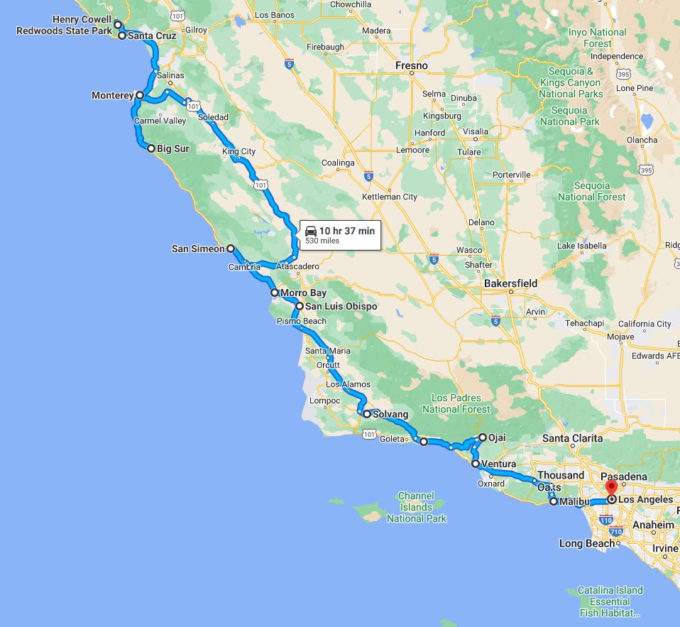
For the ultimate travel experience, the Pacific Coast Highway, also known as State Route 1, is legendary. This route is not about the mileage—which totals about 450 miles—but about the time and the views. Traveling the full length of the coast can easily take 9 to 12 hours of pure driving time, though most travelers break it into a multi-day trip.
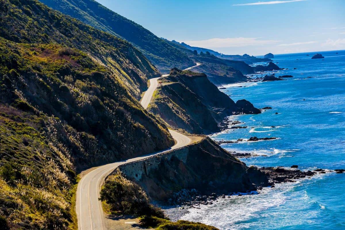
This winding road hugs the cliffs of the Pacific Ocean, offering unparalleled views of the surf. It is a masterclass in civil engineering and natural beauty, though it is prone to closures due to landslides, particularly in the Big Sur region. If you choose this route, you are choosing a destination in itself rather than a mere means of transport.
Key Landmarks and Stops Along the Coastal Routes
The distance between Los Angeles and San Francisco is punctuated by world-class attractions. For travelers taking the US Route 101 or the Pacific Coast Highway, the journey is an opportunity to check off several “bucket list” items.
Coastal Gems and Architecture
Starting north from Los Angeles, the first major stop is often Santa Barbara, known as the “American Riviera.” Its Spanish Colonial Revival architecture and the historic Old Mission Santa Barbara provide a sophisticated start to the trip.
Further north, near the town of San Simeon, sits the opulent Hearst Castle. Built by newspaper tycoon William Randolph Hearst, this estate is a testament to early 20th-century luxury and offers a fascinating look at California history. Not far from the castle, travelers often stop at the Piedras Blancas Elephant Seal Rookery to witness thousands of seals lounging on the beach.
The Majesty of Big Sur
The stretch of road through Big Sur is arguably the most famous section of the drive. Here, the Bixby Creek Bridge serves as one of the most photographed features on the West Coast. The sheer drop-offs and the dramatic meeting of the Santa Lucia Mountains with the sea create a sense of awe.
Within this region, Julia Pfeiffer Burns State Park is home to McWay Falls, a rare “tidefall” that drops 80 feet directly into the ocean. These natural landmarks make the extra miles and hours spent on the Pacific Coast Highway well worth the effort.
The Monterey Peninsula
Before reaching San Francisco, a stop in Monterey is essential. The Monterey Bay Aquarium is a global leader in marine conservation and a must-see for families. Nearby, the 17-Mile Drive in Pebble Beach offers exclusive views of world-famous golf courses and the iconic Lone Cypress.
Alternatives to Driving: Rail and Air Travel
While driving is the most common way to cover the miles between Los Angeles and San Francisco, it is certainly not the only option. Depending on your budget and schedule, flying or taking the train offers different perspectives on the distance.
The Efficiency of Flight
Flying is the fastest way to bridge the gap. The aerial distance between Los Angeles International Airport and San Francisco International Airport is approximately 340 miles. The flight itself usually takes about 1 hour and 15 minutes.
When considering the “total travel time,” however, one must factor in the commute to the airport, security lines, and baggage claim. In many cases, for travelers going from downtown to downtown, the total time spent can reach 4 hours, making the speed advantage over Interstate 5 less dramatic than it appears on paper. Other regional hubs like Burbank Airport and Oakland International Airport offer alternatives that can sometimes bypass the heavy traffic of the larger international terminals.
The Romance of the Coast Starlight
For those who want to see the sights without the stress of driving, the Amtrak Coast Starlight is a premier travel experience. This train route is widely considered one of the most beautiful in the United States.
The journey begins at Union Station in Los Angeles. The train tracks often run closer to the ocean than the highways do, particularly through Vandenberg Space Force Base, offering views that are inaccessible to cars. The trip to Emeryville or Oakland (the closest stops to San Francisco via train) takes roughly 12 hours. It is a slow-travel experience that emphasizes the grandeur of the California landscape.
Practical Tips for the California Road Trip
Successfully navigating the hundreds of miles between these two cities requires some logistical planning. California travel is subject to unique challenges, from erratic weather to heavy traffic congestion.
Understanding Traffic Patterns
Traffic is a major factor when calculating your arrival time. Leaving Los Angeles during “rush hour” (generally 7 AM to 10 AM and 3 PM to 7 PM) can add an hour or more to your journey before you even leave the city limits. Similarly, arriving in San Francisco or crossing the Bay Bridge during peak hours can be a significant bottleneck. Experienced travelers often recommend leaving at 4 AM or waiting until after 8 PM to make the drive if they are using Interstate 5.
Weather and Seasonal Considerations
California weather is diverse. While it might be 80 degrees and sunny at the Santa Monica Pier in Los Angeles, it can be 55 degrees and foggy at the Golden Gate Bridge in San Francisco.
The Central Valley, through which Interstate 5 passes, is prone to “Tule fog” in the winter months. This thick, ground-level fog can reduce visibility to near zero, making driving extremely hazardous. On the coastal routes, winter storms can lead to mudslides that close sections of the Pacific Coast Highway for months at a time. Always check the California Department of Transportation (Caltrans) website for road conditions before heading out.
Fueling and Connectivity
If you are taking Interstate 5, gas stations are plentiful, but they are often clustered in specific “service oasis” areas like Kettleman City. On the Pacific Coast Highway, however, services are much more sparse. In the Big Sur region, gas can be significantly more expensive, and cell phone reception is almost non-existent for long stretches. It is wise to download offline maps and fuel up in larger towns like San Luis Obispo or Carmel-by-the-Sea.
In conclusion, the distance from Los Angeles to San Francisco is more than a number on a map. Whether you choose the 382-mile dash through the valley or the 450-mile scenic odyssey along the Pacific, the trip represents the very best of California travel. By choosing the route that fits your schedule and interests, you can turn a long day of travel into an unforgettable adventure.
LifeOutOfTheBox is a participant in the Amazon Services LLC Associates Program, an affiliate advertising program designed to provide a means for sites to earn advertising fees by advertising and linking to Amazon.com. Amazon, the Amazon logo, AmazonSupply, and the AmazonSupply logo are trademarks of Amazon.com, Inc. or its affiliates. As an Amazon Associate we earn affiliate commissions from qualifying purchases.