
The Black Canyon of the Gunnison stands as a testament to the immense power of geological forces, a formidable natural landmark etched deep into the heart of Western Colorado. Unlike the more widely celebrated canyons of the American Southwest, the Black Canyon possesses a distinct, brooding character, defined by its extreme narrowness, dizzying depths, and the ancient, dark rock that forms its formidable walls. To truly answer “where is the Black Canyon?”, one must understand not only its precise geographical coordinates but also the profound geological processes that birthed this singular natural wonder, positioning it as one of the continent’s most spectacular, albeit often understated, landmarks.
Unveiling a Geological Marvel: The Black Canyon’s Identity
The Black Canyon is not merely a gorge; it is a profound incision, a chasm so deep and sheer that sunlight struggles to reach its depths, giving its walls their characteristic shadowed appearance. Its identity as a landmark is rooted in these extreme dimensions and the unique geology laid bare by the relentless carving of the Gunnison River. It is formally protected within the boundaries of Black Canyon of the Gunnison National Park, a designation that underscores its national significance and ensures its preservation for future generations to marvel at.
The Grandeur of the Gunnison
At its most profound point, the Black Canyon plunges to a depth of 2,722 feet at Warner Point, while its narrowest section, known as the “Narrows,” pinches to a mere 40 feet at river level. This combination of depth and constricted width creates a dramatic, almost claustrophobic environment for those who venture into its inner reaches, yet offers awe-inspiring vistas from its rim. The river responsible for this monumental undertaking, the Gunnison River, is one of Colorado’s major waterways, originating in the Elk Mountains and flowing westward to join the Colorado River. Its path through this segment of the landscape has sculpted a geological cross-section revealing billions of years of Earth’s history.
A River’s Patient Carving
The formation of the Black Canyon is a prime example of antecedent stream formation, where the Gunnison River maintained its course even as the surrounding land uplifted. Over the past 2 million years, the river has eroded through highly resistant Precambrian metamorphic and igneous rocks, primarily gneiss and schist, at an astonishing rate. This relentless downcutting, combined with the slow uplift of the Gunnison Uplift, resulted in the steep, V-shaped gorge we see today. The dark color of these ancient rocks, frequently injected with lighter-colored pegmatite dikes, contributes significantly to the canyon’s iconic “black” appearance, especially in the deep shadows it casts.
Locating the Canyon: A Geographic Overview
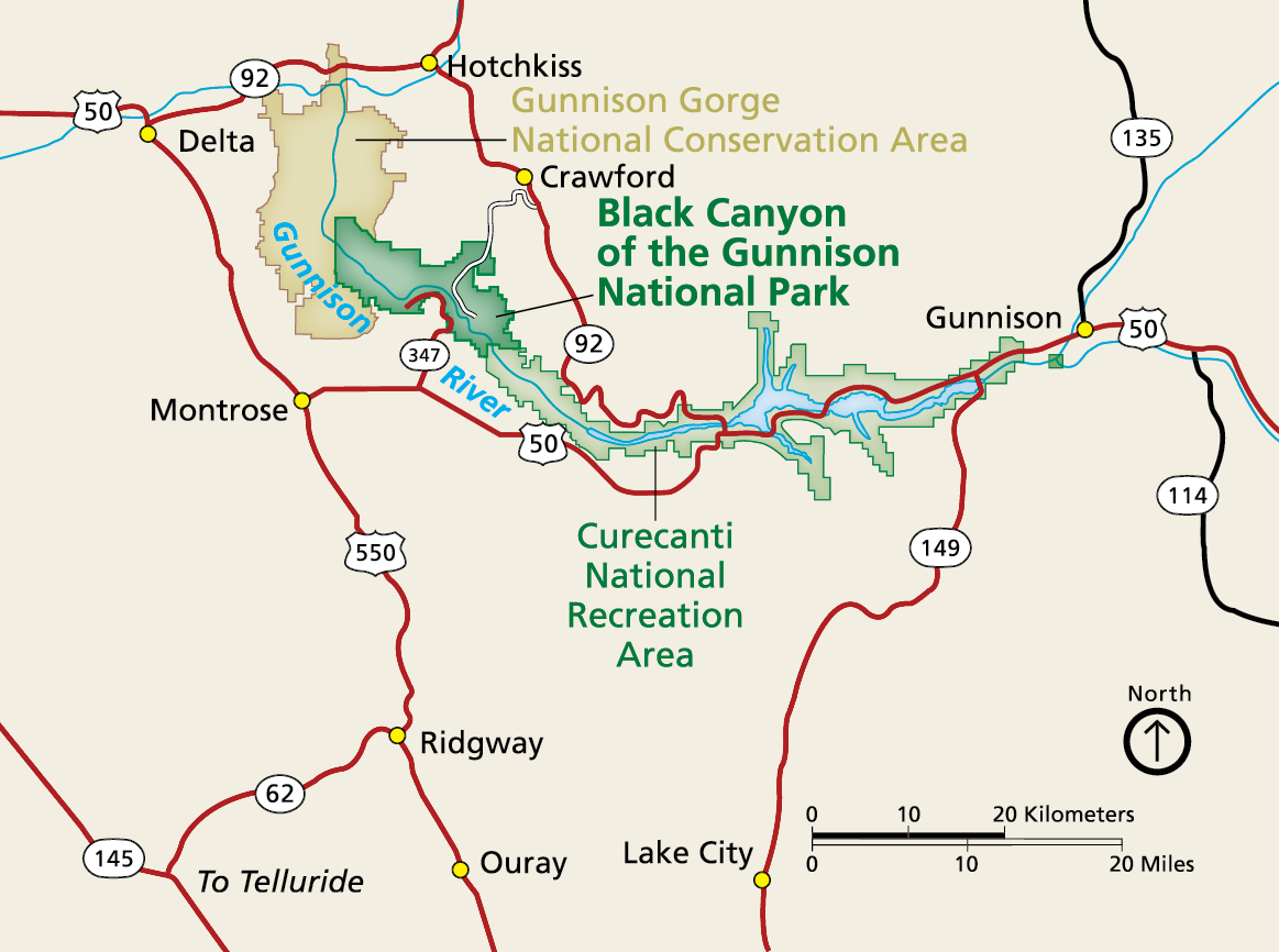
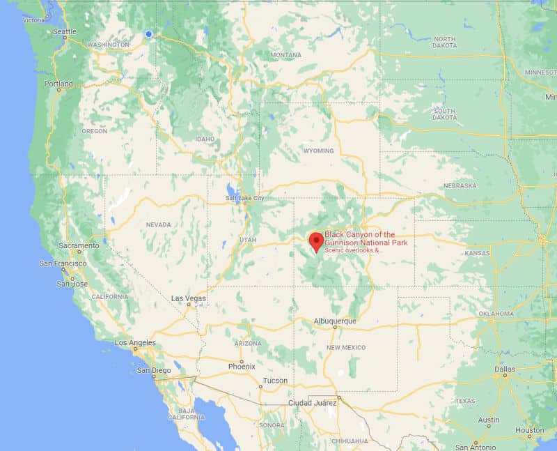
Geographically, the Black Canyon of the Gunnison National Park is situated in Mesa, Montrose, and Gunnison Counties in southwestern Colorado. It lies approximately 60 miles southeast of Grand Junction and 15 miles east of the town of Montrose. The park is distinctive for having two main, independently accessible rims: the South Rim and the North Rim, each offering different perspectives and access points to this profound natural landmark.
Black Canyon of the Gunnison National Park’s Dual Rims
The South Rim is the more developed and easily accessible of the two, located just 15 miles east of Montrose via U.S. Route 50 and Colorado State Highway 347. It hosts the primary visitor center and offers numerous overlooks and hiking trails that provide stunning, iconic views into the canyon’s depths. The North Rim, by contrast, is more remote and less developed. It can be accessed from the town of Crawford via Colorado State Highway 92 and a county road. Due to its rugged nature, the North Rim typically closes during the winter months when snow makes the unpaved access road impassable.
Proximity to Western Colorado Cities
While seemingly isolated, the Black Canyon is within reasonable driving distance of several key Colorado hubs. From Denver, the state capital, it’s approximately a 5-6 hour drive, making it a viable destination for a longer trip across the state. Grand Junction, with its regional airport, serves as a common gateway for visitors flying into the region, being just over an hour’s drive away. The nearby town of Gunnison, to the east, also provides access to the eastern stretches of the canyon and is a popular base for exploring the surrounding high-country wilderness, though it’s important to note the main national park sections are west of Gunnison.
The Unique Geology and Formation of the Canyon
The geological story of the Black Canyon is what truly sets it apart as a landmark. It exposes one of the finest cross-sections of Precambrian rock on the continent, giving scientists and casual observers alike a direct window into Earth’s ancient past.
Precambrian Basement Rocks
The majority of the canyon walls are composed of ancient crystalline rocks, predominantly Gunnison Gneiss and Boulder Creek Granodiorite. These rocks formed deep within the Earth’s crust over 1.7 billion years ago, undergoing immense heat and pressure that transformed them into their current rugged, dark, and banded appearance. Intrusions of lighter-colored pegmatite and aplite dikes, formed from molten rock forced into fractures, create striking patterns against the darker gneiss, adding to the visual drama of the canyon walls. These ancient rocks are among the oldest exposed on the planet and represent a significant portion of North America‘s continental basement.

The Power of the Gunnison River
The river’s carving power is unparalleled in this region. The Gunnison River drops at an average of 95 feet per mile within the park, making it one of the steepest river descents in North America. This steep gradient, combined with the hard, abrasive Precambrian rock and the powerful scouring action of sand and boulders carried by the fast-flowing water, allowed the river to cut downward through the uplifted landscape more quickly than it could erode horizontally. This “downcutting” process, occurring faster than the side walls could widen through weathering and erosion, is precisely what created the canyon’s signature narrow and deep profile.
Deepest and Narrowest
The Black Canyon’s status as one of the deepest and narrowest canyons relative to its width is a defining characteristic. While other canyons might be deeper, few maintain such a consistent, dramatic constriction for miles. The sheer scale, combined with the dark, unyielding rock, creates an unparalleled sense of majesty and raw geological power. The Black Canyon truly offers a unique perspective on the forces that shape our planet, a landmark where the Earth’s very core seems to rise to meet the sky.
Experiencing the Landmark: Viewing and Access
Accessing and experiencing the Black Canyon as a landmark involves navigating its distinct topography and understanding the various perspectives it offers. The park is designed to showcase the canyon’s grandeur from its rims, with limited and challenging access to its inner reaches.
North Rim vs. South Rim: Perspectives and Accessibility
The South Rim offers paved roads and a series of well-maintained overlooks, making it highly accessible for most visitors. Popular viewpoints include Gunnison Point, Painted Wall (home to Colorado’s tallest sheer cliff), and Warner Point. These provide expansive, iconic views that capture the canyon’s depth and scale. The North Rim, while requiring a longer, unpaved drive, offers a more rugged and less crowded experience. Overlooks like Chasm View and Painted Wall View provide different angles and often a quieter environment, appealing to those seeking a more solitary encounter with the landmark. It’s crucial to check road conditions for the North Rim, especially outside of peak summer months.
Scenic Drives and Overlooks
Both rims feature scenic drives punctuated by numerous pull-offs and short walking trails to various overlooks. The South Rim Drive (East Portal Road) descends steeply into the canyon to the Gunnison River, providing a rare opportunity to reach the river within the park by vehicle. However, this road is extremely steep and has size restrictions. On the North Rim, the unpaved road leads to several overlooks that are often closer to the canyon’s edge, enhancing the sense of verticality and immersion. These drives are the primary way most visitors experience the landmark’s scale and beauty.
Inner Canyon Challenges
Direct access to the Gunnison River at the bottom of the Black Canyon is exceedingly difficult and is reserved for experienced and properly equipped hikers, climbers, and whitewater enthusiasts. There are no maintained trails to the river from the rims; instead, “unmaintained routes” or “scrambles” descend precipitously down the canyon walls. These descents are challenging, require route-finding skills, and often involve navigating loose scree and steep rock faces. For most visitors, the grandeur of the Black Canyon is best appreciated from its majestic rims, offering unparalleled views of its profound depths without the inherent risks of inner-canyon exploration.
The Black Canyon’s Natural Heritage and Preservation
Beyond its geological magnificence, the Black Canyon is also a vital ecological landmark, supporting a diverse array of flora and fauna adapted to its unique, extreme environment. Its designation as a national park is crucial for protecting both its geological features and its biological diversity.
Flora and Fauna of the Canyon
Despite its harsh appearance, the Black Canyon supports a surprising variety of life. The rim areas are dominated by pinyon-juniper woodlands, sagebrush, and various grasses, while the inner canyon, especially near the river, features riparian vegetation such as cottonwoods and willows. Wildlife commonly seen includes mule deer, elk, bighorn sheep, and various raptors, including golden eagles and peregrine falcons, which nest on the canyon walls. The Gunnison River itself is home to trout, making it a revered destination for experienced anglers willing to tackle its challenging access. The stark contrasts in elevation and microclimates create distinct habitats within this compact area.
National Park Status and Conservation Efforts
Established as a national park in 1999, the Black Canyon of the Gunnison National Park plays a critical role in preserving this remarkable landmark. The National Park Service actively works to protect the canyon’s geological integrity, its pristine dark skies (it’s an International Dark Sky Park), and its unique ecosystems. Conservation efforts include managing visitor impact, preserving natural soundscapes, and conducting research on the canyon’s geology and ecology. This protected status ensures that the Black Canyon remains an awe-inspiring, wild landmark, allowing its natural processes to continue undisturbed for generations to come, standing as a monument to Earth’s enduring power and beauty in Colorado’s rugged landscape.
LifeOutOfTheBox is a participant in the Amazon Services LLC Associates Program, an affiliate advertising program designed to provide a means for sites to earn advertising fees by advertising and linking to Amazon.com. Amazon, the Amazon logo, AmazonSupply, and the AmazonSupply logo are trademarks of Amazon.com, Inc. or its affiliates. As an Amazon Associate we earn affiliate commissions from qualifying purchases.