
Navigating the administrative landscape of any state can be a complex endeavor, and for visitors or new residents of Oregon, understanding which district they fall under is crucial for a myriad of reasons. From voting and taxation to accessing specific local services and understanding regional planning, district identification is foundational to civic engagement and efficient navigation of the state’s governance. This guide aims to demystify the various districts within Oregon and provide clear pathways for individuals to ascertain their precise location within these administrative boundaries.
Understanding Oregon’s Jurisdictional Framework
Oregon is divided into several overlapping layers of jurisdiction, each serving a distinct purpose. When asking “What district am I in?”, the answer typically refers to one or more of the following: Congressional Districts, State Legislative Districts, Judicial Districts, and various special districts (like school districts, port districts, or service districts). Each of these is defined by geographical boundaries and serves specific governmental functions.
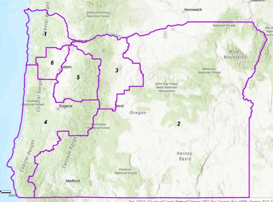
Congressional Districts
Oregon is represented in the U.S. House of Representatives by members elected from its congressional districts. These districts are drawn to ensure roughly equal population sizes, allowing for effective representation in the federal government. Currently, Oregon has six congressional districts, each encompassing a unique mix of urban, suburban, and rural areas.
To determine your congressional district, you can often find this information on your voter registration card or by using online lookup tools provided by the Oregon Secretary of State or the U.S. Census Bureau. Knowing your congressional district is vital for contacting your federal representatives on matters of national policy.
State Legislative Districts
At the state level, Oregon is divided into State Senate Districts and State House of Representatives Districts. These districts are redrawn periodically, usually following the decennial census, to reflect population shifts. The State Senate has 30 districts, and the House of Representatives has 60 districts, meaning each representative serves a smaller population base than a U.S. Representative.
These elected officials are responsible for crafting and passing state laws, shaping the budget, and overseeing state agencies. Identifying your state legislative district is essential for engaging with your state-level government on issues that directly impact Oregon.
Judicial Districts
The judicial system in Oregon is organized into judicial districts, which generally align with county boundaries, though some larger counties may have multiple judicial divisions. These districts are responsible for administering justice within their geographical areas, encompassing trial courts (Circuit Courts) that handle criminal and civil cases.
Understanding your judicial district is important if you are involved in legal proceedings or need to access court services. Information about the specific courts within your district can usually be found on the Oregon Judicial Department’s website.
Special Districts
Beyond federal and state legislative and judicial boundaries, Oregon has a vast network of special districts. These are independent, special-purpose governmental units established to provide specific services not typically covered by general-purpose governments like cities or counties. Examples include:
- School Districts: Responsible for public education.
- Port Districts: Promote economic development and manage port facilities.
- Fire Districts: Provide fire protection and emergency medical services.
- Water/Wastewater Districts: Manage water supply and sewage treatment.
- Parks and Recreation Districts: Develop and maintain public parks and recreational facilities.
- Library Districts: Fund and operate public libraries.
Each special district has its own boundaries, which often do not align neatly with other district types or even city/county lines. These districts are crucial for the provision of essential local services and are governed by elected boards.
How to Determine Your District in Oregon
Pinpointing your exact district requires accessing specific information, often related to your residential address. Fortunately, Oregon provides several accessible resources for residents and visitors to find this data.
Utilizing Online Geographic Information Systems (GIS)
Many Oregon government entities, from the state level down to individual counties and cities, offer sophisticated online GIS portals. These interactive maps allow users to input their address and view various jurisdictional overlays, including congressional districts, legislative districts, school districts, and more.
- State Level Resources: The Oregon Department of Revenue, for instance, may have tools that help identify tax districts, which often align with special districts. The Oregon Secretary of State’s website is a primary resource for information on elections and will likely have tools to identify your political districts.
- County and City Websites: Most county and major city websites in Oregon will have dedicated GIS departments or pages that provide interactive maps. Searching for “[County Name] GIS” or “[City Name] Mapping” can lead you to these valuable resources.

Checking Official Documentation
Your residential address is the key to unlocking your district information. Several official documents that you likely possess can provide direct answers or point you to the right resources.
- Voter Registration Card: If you are a registered voter in Oregon, your voter registration card will typically list your congressional, state legislative, and often your school district.
- Property Tax Statements: These statements, sent annually by your county assessor’s office, will clearly indicate the various taxing districts you are part of, which will include school districts, fire districts, and other service districts that levy taxes.
- Utility Bills: While less common, some utility bills might indirectly indicate your service district, especially for specialized services like rural water or sewer.
Contacting Local Government Offices
If online tools or existing documentation do not provide the clarity you need, direct contact with local government offices is a reliable next step.
- County Clerk’s Office: This office is a central hub for information regarding elections and voter services. They can definitively tell you your political districts and often direct you to resources for special districts.
- County Assessor’s Office: For tax-related districts and property boundaries, the assessor’s office is the most authoritative source.
- City Hall: If you reside within a city’s limits, city hall can provide information about city-specific services and any districts that operate within or overlap with the city.
- School District Administration: For specific questions about your educational district, contacting the administrative offices of your local school district is the most direct route.
The Significance of Knowing Your District
Understanding which district you reside in extends beyond mere geographical classification; it has tangible implications for your life as a resident or visitor in Oregon.
Civic Participation and Representation
- Voting: Your district directly determines who you vote for at the federal, state, and local levels. Knowing your districts ensures you are informed about the candidates running to represent your interests and that you cast your ballot in the correct elections.
- Contacting Representatives: Effective advocacy requires knowing who represents you. Whether you need to address concerns with a U.S. Representative, a State Legislator, or a local school board member, identifying your district is the first step in making your voice heard.
Access to Services and Resources
- Educational Opportunities: School districts dictate the public education system available to your children. Knowing your district is essential for enrollment, understanding school board decisions, and accessing district-specific programs.
- Public Safety: Fire districts, police departments (often city or county-level), and other emergency services operate within defined boundaries. Knowing these boundaries ensures you understand response times and service provisions.
- Utilities and Infrastructure: Water, sewer, transportation (like port districts or transit districts), and other vital infrastructure services are often managed by special districts. Your district determines which entity is responsible for these services in your area.
Economic and Development Planning
- Local Taxes: Special districts often levy local taxes to fund their operations. Understanding your tax districts helps clarify your tax obligations and how your tax dollars are being used.
- Community Development: Zoning, land use planning, and economic development initiatives are often shaped by local and regional districts. Awareness of these districts can provide insight into current and future development in your community.
Navigating Oregon’s Diverse Regions
Oregon is a state of remarkable geographical diversity, from the rugged Oregon Coast to the high desert of Eastern Oregon and the lush Willamette Valley. This diversity influences the composition of its districts.
Urban vs. Rural Districts
Metropolitan areas like Portland, Salem, and Eugene are characterized by densely populated congressional and legislative districts, often interspersed with numerous overlapping special districts for transit, libraries, and schools. In contrast, rural areas may have larger geographical districts with fewer people, and special districts might consolidate services across broader areas. For example, a single rural fire district might cover a vast geographic expanse, while an urban fire district might be responsible for a few square miles within a city.
Coastal, Valley, and Mountain Districts
The unique needs of different regions give rise to specialized districts. Coastal communities may have port districts focused on maritime industries, while communities in the Willamette Valley might have districts focused on agriculture or wine production. Mountainous regions may have specialized districts for wildfire protection or forest management.

Conclusion
Identifying your district in Oregon is a straightforward yet vital step for any resident or visitor. By leveraging online resources, official documentation, and local government contacts, you can confidently ascertain your position within the state’s intricate network of congressional, legislative, judicial, and special districts. This knowledge empowers you to participate effectively in civic life, access essential services, and understand the governance structures that shape your daily experience in the Beaver State. Whether you’re a long-time resident or a newcomer exploring the beauty of Oregon, understanding your districts is fundamental to truly belonging and engaging with your community.
LifeOutOfTheBox is a participant in the Amazon Services LLC Associates Program, an affiliate advertising program designed to provide a means for sites to earn advertising fees by advertising and linking to Amazon.com. Amazon, the Amazon logo, AmazonSupply, and the AmazonSupply logo are trademarks of Amazon.com, Inc. or its affiliates. As an Amazon Associate we earn affiliate commissions from qualifying purchases.