
The drive from Los Angeles to San Francisco is a classic Californian journey, offering a diverse range of landscapes and experiences. Whether you’re seeking the efficiency of a direct route or the scenic beauty of a coastal detour, understanding the distances and travel times is key to planning your adventure. This guide breaks down the primary routes, estimated travel times, and factors that can influence your journey, helping you make the most of this iconic West Coast trip.
The Direct Route: Speed and Efficiency
For those prioritizing time, the most direct path between Los Angeles and San Francisco primarily utilizes inland freeways. This route is designed for swift transit, making it an excellent option for business travelers or those with limited vacation time.
Distance and Estimated Travel Time
The most common direct route covers approximately 380 to 400 miles, depending on the specific starting and ending points within each metropolitan area. When traffic conditions are favorable and without significant stops, the driving time is typically estimated at 5 to 6 hours.
Key Highways Involved
- Interstate 5 (I-5): This is the backbone of the direct route. It’s a major north-south freeway that cuts through the heart of California. While it’s the fastest, it also tends to be the most utilitarian, with less scenic appeal.
- Connecting Freeways: Depending on your exact starting point in Los Angeles, you might begin on routes like US Route 101 or Interstate 405 before merging onto I-5 North. Similarly, as you approach San Francisco, you’ll transition onto roads like Interstate 580 and eventually the San Francisco-Oakland Bay Bridge.
Factors Affecting Travel Time on I-5
- Traffic: Los Angeles and the surrounding areas are notorious for heavy traffic, especially during peak commute hours (morning and late afternoon/early evening). Similarly, approaching the San Francisco Bay Area, you can encounter significant congestion. Planning your departure to avoid these times can shave considerable minutes, or even hours, off your journey.
- Road Construction: Major freeway arteries like I-5 are subject to ongoing maintenance and construction projects. Detours or lane closures can cause delays. Checking real-time traffic apps before and during your drive is highly recommended.
- Weather: While California generally enjoys good weather, occasional rain can impact driving conditions, especially in the mountains or during winter months. Fog can also be a factor, particularly in the northern parts of the state.
The Coastal Route: Scenic Splendor and Iconic Stops
For travelers who have the time and desire to experience the breathtaking beauty of the Californian coast, the Pacific Coast Highway (PCH), often referred to as Highway 1, offers an unforgettable journey. This route is significantly longer and more time-consuming but rewards travelers with unparalleled vistas and charming coastal towns.
Distance and Estimated Travel Time
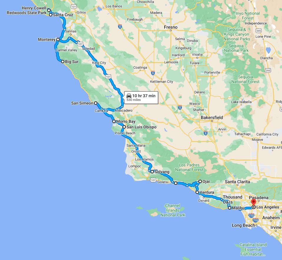
The PCH route is considerably longer, stretching to approximately 500 to 550 miles depending on the exact segments of Highway 1 you choose to follow. The driving time can range from a minimum of 10 to 12 hours of pure driving, but realistically, this journey is best enjoyed over 2 to 4 days to allow for exploration and relaxation.
Navigating the Pacific Coast Highway
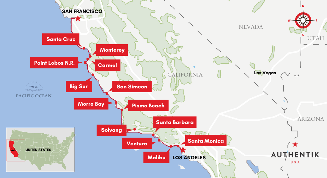
- Starting Point: You can begin your PCH adventure from various points in Southern California. A common starting point is near Santa Monica, where you can join Highway 1 heading north.
- Key Regions and Attractions:
- Central Coast: This stretch includes picturesque towns like Santa Barbara, renowned for its Spanish colonial architecture and wine country. Further north, you’ll find the charming Danish village of Solvang and the vibrant city of San Luis Obispo.
- Big Sur: This is the undisputed crown jewel of the PCH. The dramatic cliffs, redwood forests, and crashing waves create a truly awe-inspiring landscape. Key viewpoints include Bixby Creek Bridge and the iconic McWay Falls at Julia Pfeiffer Burns State Park.
- Monterey Peninsula: This region boasts the famous 17-Mile Drive with its Lone Cypress, the historic city of Monterey with its world-class Monterey Bay Aquarium, and the elegant town of Carmel-by-the-Sea.
- Approaching San Francisco: The final leg of the PCH journey might involve merging with US Route 101 or continuing on smaller coastal roads towards the Golden Gate Bridge.
Considerations for the Coastal Drive

- Road Conditions and Closures: Sections of Highway 1, particularly in the Big Sur area, are prone to closures due to landslides, especially after heavy rainfall. It is absolutely essential to check Caltrans (California Department of Transportation) for the latest road conditions before and during your trip.
- Driving Pace: The PCH is a winding, two-lane highway with numerous scenic pull-offs and slow-moving vehicles (RVs, cyclists). Drivers must be patient and adapt to a slower pace. It is not a route for rushing.
- Cell Service: Cell service can be spotty to non-existent in certain stretches of Big Sur. Downloading offline maps and important information is highly recommended.
- Accommodation and Dining: While there are charming towns along the way, accommodations and dining options can be more limited and expensive in some remote areas. Booking in advance, especially during peak season, is crucial.
Alternative Routes: Blending Scenery and Speed
For travelers seeking a compromise between the speed of the inland route and the unparalleled scenery of the coast, several alternative routes offer a balanced experience. These options often involve utilizing parts of both I-5 and PCH, or exploring scenic byways that offer unique perspectives.
The US Route 101 Option
US Route 101 offers a middle ground. It runs largely parallel to the coast for much of its length but is a more developed highway than the PCH, allowing for quicker travel while still providing coastal views and access to charming towns.
Key Features of US Route 101
- Distance and Time: The distance is comparable to the direct route, around 400-450 miles, but the travel time is longer, typically 7 to 9 hours without significant stops.
- Scenic Highlights: This route passes through vibrant cities like Santa Barbara and San Luis Obispo, offering easy access to their attractions. It also winds through the rolling hills of the Santa Ynez Valley wine region and the lush agricultural landscapes of the Salinas Valley.
- Traffic Considerations: While generally less congested than I-5, US Route 101 can experience significant traffic delays in and around major cities.
Inland Detours and Wine Country
For those interested in California’s renowned wine regions, a detour through the Central Valley or the coastal mountain ranges can be incorporated. Routes like State Route 152 can connect I-5 to Monterey or the coast, offering a different perspective. Exploring areas like the Paso Robles wine country or the famed vineyards of Sonoma and Napa (though these are closer to San Francisco itself) can be part of a longer, more leisurely trip.
Planning Your Trip: Essential Considerations
Regardless of the route you choose, careful planning is essential for a smooth and enjoyable journey from Los Angeles to San Francisco.
Choosing the Right Vehicle
- Fuel Efficiency: For the direct route, a fuel-efficient vehicle will help minimize costs, especially with gas prices fluctuating.
- Comfort for Long Drives: If opting for the PCH, a comfortable vehicle with good suspension is advisable for the winding roads and longer travel times.
- Navigation: Ensure your vehicle’s GPS is up-to-date, or rely on smartphone navigation apps. For the PCH, having offline maps downloaded is a critical backup.
Accommodation and Dining
- Book in Advance: Especially during peak travel seasons (summer, holidays, weekends), booking hotels and popular restaurants in advance is highly recommended, particularly along the Pacific Coast Highway.
- Variety of Options: From luxury resorts in Santa Barbara to charming boutique inns in Carmel-by-the-Sea and standard motels along I-5, there are options to suit every budget and preference.
Best Time to Travel
- Spring (March-May): Offers pleasant weather, fewer crowds, and wildflowers blooming in many areas.
- Fall (September-November): Generally considered the best time for the PCH, with clear skies, fewer crowds than summer, and beautiful autumn colors in some regions.
- Summer (June-August): Popular but can be crowded and expensive. Coastal fog is common in the mornings and evenings.
- Winter (December-February): Can bring rain, especially to Northern California. Road closures on the PCH are more likely. However, it’s the least crowded season.
By understanding the distances, travel times, and myriad of options available, you can tailor your journey from Los Angeles to San Francisco to perfectly match your travel style and preferences.
LifeOutOfTheBox is a participant in the Amazon Services LLC Associates Program, an affiliate advertising program designed to provide a means for sites to earn advertising fees by advertising and linking to Amazon.com. Amazon, the Amazon logo, AmazonSupply, and the AmazonSupply logo are trademarks of Amazon.com, Inc. or its affiliates. As an Amazon Associate we earn affiliate commissions from qualifying purchases.