
The East River is a vital artery of New York City, a tidal strait that separates Manhattan, the Bronx, and Queens from Long Island. While it might appear a mere waterway from the iconic skyline views, its depths hold significant ecological, navigational, and historical importance. Understanding the depth of the East River is crucial for maritime traffic, infrastructure development, and appreciating the complex environmental dynamics of this bustling urban landscape. The depth is not uniform, varying considerably from its shallowest points to its deepest channels, influenced by natural topography and extensive human intervention over centuries.
Navigational Channels and Depth Variations
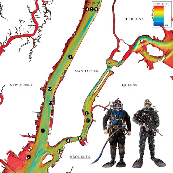
The primary factor influencing the perceived depth of the East River is the presence of maintained navigational channels. These channels are meticulously dredged and maintained by authorities such as the United States Army Corps of Engineers to accommodate the passage of commercial vessels, ferries, and recreational boats. Without these interventions, much of the river would be significantly shallower, rendering it impassable for modern shipping.
The Main Channel
The central navigational channel of the East River is designed to be deep enough for large ships to transit safely. This channel typically reaches depths of approximately 40 to 45 feet (about 12 to 14 meters). This allows for the significant flow of goods and people that rely on the river for commerce and transportation. Ports along the East River, such as those in Brooklyn and Queens, depend on these depths to maintain their operational capacity.
Tributary Inflows and Shallower Areas
As one moves away from the main channel, particularly near the shorelines and where smaller tributaries once fed into the river, the depth decreases considerably. In some of these areas, the depth can be as little as 10 to 20 feet (about 3 to 6 meters), and in certain very shallow spots, it might be even less, especially at low tide. These areas are more prone to silting, requiring periodic dredging to maintain even these reduced depths.
Influence of Bridges and Infrastructure
The construction of numerous bridges and tunnels across the East River has also had an impact on its bathymetry. The foundations of structures like the Brooklyn Bridge, the Manhattan Bridge, and the Williamsburg Bridge extend deep into the riverbed. While these do not fundamentally alter the navigable depths in the main channels, they represent significant underwater obstructions and can influence local currents and sediment deposition patterns. The Robert F. Kennedy Bridge (formerly Triborough Bridge) and the Queens–Midtown Tunnel also involve substantial underwater infrastructure that impacts the river’s floor.
Tidal Influence on Perceived Depth
It’s important to remember that the East River is a tidal strait, meaning its water level fluctuates significantly with the incoming and outgoing tides from the Atlantic Ocean. The tidal range in the East River can be substantial, typically around 4 to 6 feet (1.2 to 1.8 meters). This means that a specific spot can appear several feet shallower at low tide than it does at high tide. Navigational depths are always stated with reference to a specific tidal datum, usually mean low water, to ensure a consistent baseline for safe passage.
Ecological Significance and Marine Life
The depth of the East River plays a critical role in supporting its diverse marine ecosystem. While historically polluted, significant restoration efforts have led to a surprising resurgence of marine life, and the varied depths create different habitats for various species.
Habitat Zones and Depth
The deeper, more oxygenated waters of the main channel provide suitable environments for larger fish species and benthic organisms. As the river shallows towards the edges, different types of habitats emerge, supporting a different array of plant and animal life. Submerged vegetation, where present, thrives in shallower, sunlit areas. The varied depths create a mosaic of ecological niches that contribute to the overall biodiversity of the waterway.
Impact on Water Quality

Depth also influences water circulation and mixing within the East River. Deeper areas can stratify under certain conditions, leading to variations in dissolved oxygen levels from surface to bottom. Understanding these depth-related characteristics is essential for managing water quality and addressing issues such as hypoxia, which can harm aquatic life. The inflow of freshwater from tributaries and the tidal exchange with the Atlantic Ocean are critical in oxygenating the water, and the river’s depth directly impacts how effectively these processes occur throughout its volume.
Historical Context and Human Alteration
The current depths of the East River are not solely a product of natural processes. Centuries of human activity, from early colonial settlements to modern mega-projects, have dramatically reshaped its underwater topography.
Early Harbor Development
In the early days of New York City, the East River was significantly shallower. The development of piers and wharves, along with the dumping of waste and debris, began to alter the riverbed. As the city grew into a major global port, the need for deeper channels became paramount. This led to the first major dredging efforts, transforming the river’s natural contours.
The Era of Dredging and Infrastructure Projects
The 20th century saw extensive dredging projects undertaken to create and maintain the deep-water channels necessary for the booming shipping industry. The construction of tunnels like the Hugh L. Carey Tunnel (formerly the Battery Tunnel) and the Queens–Midtown Tunnel involved massive excavation beneath the riverbed, further altering its profile. Similarly, the extensive pile-driving for bridge foundations and piers has created localized variations in depth and substrate composition. The ongoing need to remove accumulated sediment is a constant reminder of the dynamic nature of the riverbed and the continuous human effort required to maintain its navigability.
Modern Management and Future Considerations
Today, the management of the East River involves a complex interplay between maintaining navigational depths, protecting fragile ecosystems, and ensuring the safety of underwater infrastructure. Environmental regulations now govern dredging activities, aiming to minimize the impact on marine life and dispose of dredged material responsibly. Future plans for the East River may involve further ecological restoration, the development of new underwater infrastructure, and the adaptation to changing climate conditions, all of which will continue to be influenced by its depths and the ongoing management of its waterway.
Experiencing the East River: Depths and Perspectives
While a casual observer on the shore or a passenger on a ferry might not ponder the exact fathoms beneath them, the depth of the East River is a tangible element that shapes the city’s experience. From the imposing structures that pierce its waters to the marine life that inhabits its depths, the river’s dimensions are woven into the fabric of New York City.
Views from Above and Below
From the observation decks of skyscrapers like One World Trade Center or the heights of bridges, the vastness of the East River is apparent, hinting at the unseen depths. Conversely, a boat tour offers a more intimate perspective, where the water’s surface is the immediate reality, yet the knowledge of the channel’s depth beneath provides a sense of scale and the unseen world of maritime activity. For divers and marine biologists, the depths are a direct point of study, revealing a dynamic environment that belies its urban setting.
Economic and Recreational Importance
The maintained depths are fundamental to the East River’s role as a commercial waterway, facilitating trade and supporting jobs. Beyond commerce, the river is a site for recreational activities, from kayaking and paddleboarding in shallower areas to larger boat excursions that traverse the main channels. The varying depths create opportunities for different forms of enjoyment and interaction with this crucial urban waterway. The presence of the Governors Island ferry and other transit options highlight how the river’s accessibility, determined by its depth, connects different parts of the city.
A Living Waterway
Ultimately, the East River is more than just a body of water; it’s a dynamic, living entity shaped by both nature and human endeavor. Its depths, ranging from relatively shallow near the shores to carefully maintained deep channels, are a testament to its complex history and its ongoing importance to New York City. Whether viewed as a vital trade route, an ecological habitat, or a scenic backdrop, understanding its dimensions provides a deeper appreciation for this iconic urban waterway. The ongoing efforts to monitor and manage its depths underscore its continued significance as a cornerstone of the metropolis.
LifeOutOfTheBox is a participant in the Amazon Services LLC Associates Program, an affiliate advertising program designed to provide a means for sites to earn advertising fees by advertising and linking to Amazon.com. Amazon, the Amazon logo, AmazonSupply, and the AmazonSupply logo are trademarks of Amazon.com, Inc. or its affiliates. As an Amazon Associate we earn affiliate commissions from qualifying purchases.