
The landscape of Los Angeles is defined by a paradoxical beauty. To the west, the glittering Pacific Ocean laps at the shores of Santa Monica, while to the north and east, the rugged, sun-drenched slopes of the Santa Monica Mountains and the San Gabriel Mountains provide a dramatic backdrop for the sprawling metropolis. However, this natural splendor comes with a volatile history. The region’s iconic chaparral ecosystem is fundamentally fire-adapted, meaning that fire is not an anomaly in Southern California, but rather a recurring, albeit destructive, environmental force. Understanding how these devastating wildfires originate requires a deep dive into the intersection of extreme climate patterns, human infrastructure, and the unique ecology of the United States.

The Atmospheric Catalyst: Santa Ana Winds and Extreme Climate
The primary driver of the most catastrophic fire events in Los Angeles County is the meteorological phenomenon known as the Santa Ana Winds. These are strong, extremely dry, down-slope winds that originate inland over the high deserts of the Great Basin.
The Mechanics of Fire Spread
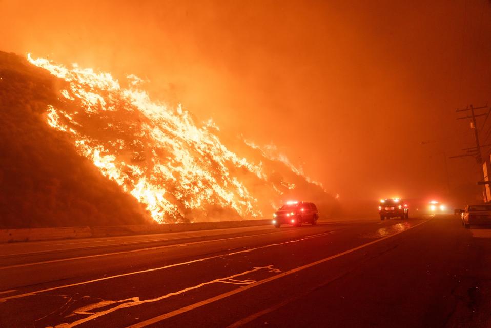
As these winds descend from the Sierra Nevada and across the arid terrain, they compress and heat up, creating a “föhn” wind effect. By the time they reach the coastal plains of Southern California, relative humidity levels often plummet to near single digits. Vegetation, having been baked by a long summer and a lack of significant precipitation, becomes incredibly desiccated. In these conditions, even the smallest spark can transform into an inferno in a matter of seconds. The winds act as a bellows, driving flames across canyon ridges and leaping across wide freeways like the Interstate 405, turning the suburban periphery into a fire corridor.
The Human Factor: Infrastructure and Accidental Ignitions
While climate sets the stage, human activity is almost exclusively responsible for starting the fires that threaten the Bel Air estates and the rustic foothills of Sylmar. Unlike other regions where lightning strikes are a major source of ignition, the fires in the Los Angeles Basin are rarely caused by natural phenomena.
Electrical Grid Failures
A significant portion of the most destructive wildfires in California has been traced back to utility equipment. High winds can bring down power lines or cause “arcing,” where electricity jumps between equipment and nearby vegetation. Because the terrain surrounding cities like Burbank and Malibu is often dense with dry brush, utility companies have increasingly implemented Public Safety Power Shutoffs (PSPS) during extreme wind events. These preventive measures are designed to mitigate the risk of a downed line sparking a catastrophic blaze, though they underscore the fragility of the power grid in a changing climate.
Accidental Human Negligence
Beyond infrastructure, the proximity of residential development to wilderness areas—often called the Wildland-Urban Interface (WUI)—is a primary factor. In places like the Hollywood Hills, the urban density pushes directly into fire-prone chaparral. Ignition sources in these areas are varied but consistent:
- Vehicle-Related Sparks: A vehicle pulling a trailer with a dragging chain, a car backfiring, or a catalytic converter igniting dry grass on the side of a road like the Pacific Coast Highway.
- Equipment Use: The operation of lawnmowers, weed whackers, or construction tools that strike rocks and create sparks.
- Campfires and Cigarettes: Despite strict fire bans, human carelessness remains a consistent, if frustrating, factor in the ignition of wildfires near hiking trails in the Angeles National Forest.
The Ecology of Fire: Why the Landscape Burns
To understand the wildfires of Los Angeles, one must look at the plants themselves. The native vegetation, dominated by scrub oak, ceanothus, and manzanita, has evolved to depend on periodic fire to clear out old growth and stimulate seed germination.
The Problem of Invasive Species
The issue is exacerbated by the encroachment of non-native, invasive grasses such as cheatgrass. These grasses grow quickly after the winter rains and turn into a golden, highly flammable carpet by late spring. Unlike native shrubs, which may have fire-retardant properties or deep root systems, these invasive grasses act as “fine fuels.” They carry flames much faster than woody shrubs, allowing fires to spread across the landscape with terrifying speed. When a fire breaks out near areas like Topanga State Park, these fine fuels often serve as the bridge that allows a small ignition to reach larger, more volatile brush.
The History of Fire Suppression
For the better part of the 20th century, fire management in the United States focused on total suppression. Every wildfire, no matter how small, was treated as a disaster to be extinguished immediately. While this protected homes, it also led to an unnaturally high buildup of “fuel loads”—dead branches, fallen trees, and overgrown thickets—in forests like the San Bernardino National Forest. Now, when fires do break out, they are often much hotter and more difficult to contain than they would have been had the natural cycle of smaller, cooler fires been allowed to occur periodically.
Planning for a Resilient Future
As the urban footprint of Los Angeles continues to expand into once-remote areas, the challenge of wildfire management has shifted from simple suppression to long-term adaptation.
Hardening the Urban Interface
Modern urban planning in Southern California now emphasizes “hardening” homes against fire. This includes using fire-resistant building materials, clearing “defensible space” around structures, and ensuring that landscaping in high-risk areas consists of native, low-water, and fire-resistant plants. The goal is to create a buffer that prevents a wildfire from turning into a home-to-home disaster, such as those historically witnessed in the canyons near Pasadena.

Public Awareness and Responsibility
The reality of living in Los Angeles means accepting that wildfires are a seasonal feature of the landscape. Authorities now prioritize real-time data, using satellite imagery and sophisticated meteorological modeling to track the Santa Ana Winds and predict fire behavior with increasing accuracy. However, the most effective tool remains human awareness. By respecting red-flag warnings, avoiding the use of machinery during high-wind events, and supporting efforts to clear dead brush in areas bordering the Santa Monica Mountains, residents and visitors alike play a critical role in preventing the next major blaze. While we cannot change the California climate, understanding how these fires start is the first step toward living more sustainably within this beautiful, fire-prone, and legendary landscape.
LifeOutOfTheBox is a participant in the Amazon Services LLC Associates Program, an affiliate advertising program designed to provide a means for sites to earn advertising fees by advertising and linking to Amazon.com. Amazon, the Amazon logo, AmazonSupply, and the AmazonSupply logo are trademarks of Amazon.com, Inc. or its affiliates. As an Amazon Associate we earn affiliate commissions from qualifying purchases.