
For many travelers planning a journey to the United States and specifically to the Central Pacific, the state of Hawaii represents a dreamscape of volcanic peaks, emerald valleys, and azure waters. However, a common misconception for first-time visitors is that the islands are clustered closely together, perhaps within a short boat ride or even a visible distance of one another at all times. In reality, the Hawaiian Islands are part of a vast archipelago that stretches over 1,500 miles. Understanding how far apart these islands are is essential for any travel itinerary, as it dictates everything from your choice of inter-island flights to the amount of time you spend exploring each unique destination.

Understanding the Geography of the Hawaiian Archipelago
The geography of Hawaii is defined by its volcanic origins. The islands were formed by a “hotspot” in the Earth’s crust, with the Pacific Plate moving slowly toward the northwest. This geological conveyor belt created a chain of islands that grow older as you move away from the southeastern end of the chain. While there are 137 islands in the entire state, including various atolls and reefs, the focus for most travelers remains on the eight main islands: Kauai, Oahu, Molokai, Lanai, Maui, the Island of Hawaii (often called the Big Island), Niihau, and Kahoolawe.
The distances between these major landmasses vary significantly. Because the islands are separated by deep-water channels, the primary mode of travel is by air. Only two of the main islands—Maui and Lanai—are currently connected by a reliable public passenger ferry. This geographical reality makes Hawaii a “fly-to” destination for almost every segment of a multi-island trip.
The Significance of the Channels
The gaps between the islands are known as channels, and they are notorious for their strong currents and wind-tunnel effects. The Kauai Channel (or Kaieiewaho Channel) separates Kauai from Oahu and is one of the widest and roughest expanses in the main chain. Conversely, the Auau Channel between Maui and Lanai is relatively narrow and sheltered, which is why a ferry service is feasible there. Knowing the distance and the nature of these channels helps travelers understand why inter-island flights are the standard rather than a luxury.
Inter-Island Distances: A Closer Look at the Main Eight
When planning a travel route, knowing the approximate mileage between the major hubs is vital. Most inter-island travel originates or passes through Honolulu on Oahu, which serves as the central transportation hub for the entire state.
From Oahu to the Neighbor Islands
Oahu, known as “The Gathering Place,” is located in the middle of the main chain. From Daniel K Inouye International Airport in Honolulu, the distances to other island airports are as follows:
- To Kauai: The distance to Lihue Airport is approximately 102 miles. This flight usually takes about 35 to 45 minutes.
- To Maui: The flight to Kahului Airport is about 101 miles, also averaging 40 minutes in the air.
- To the Island of Hawaii: There are two main destinations here. Kona International Airport is approximately 163 miles from Honolulu, while Hilo International Airport is about 210 miles away. These flights range from 45 to 60 minutes.
- To Molokai: Molokai Airport is only 54 miles from Honolulu, making it one of the shortest hops in the chain.
- To Lanai: The distance to Lanai Airport is roughly 72 miles.
The Maui County Cluster
One of the most popular regions for island hopping is Maui County, which includes Maui, Molokai, Lanai, and the uninhabited Kahoolawe. Because these islands are geographically closer to one another, they offer a different travel dynamic. On a clear day, you can stand on Kaanapali Beach in Maui and see the coastlines of Molokai and Lanai across the water. The Pailolo Channel between Maui and Molokai is only about 8.8 miles wide at its narrowest point.
The Isolation of Kauai and the Big Island
In contrast, Kauai and the Island of Hawaii are the “bookends” of the main chain and feel much more isolated. Kauai is separated from Oahu by the expansive Kauai Channel. Meanwhile, the Alenuihaha Channel between Maui and the Big Island is roughly 30 miles wide but is known for being extremely deep and subject to high winds, making it one of the most challenging channels to navigate by boat.
Navigating the Channels: Transportation and Travel Logistics
Because the distances are significant and the waters are rough, the travel experience in Hawaii is largely centered around regional aviation. For the traveler, this means that “island hopping” requires more than just a casual boat ride; it involves airport security, rental car returns, and scheduled departures.
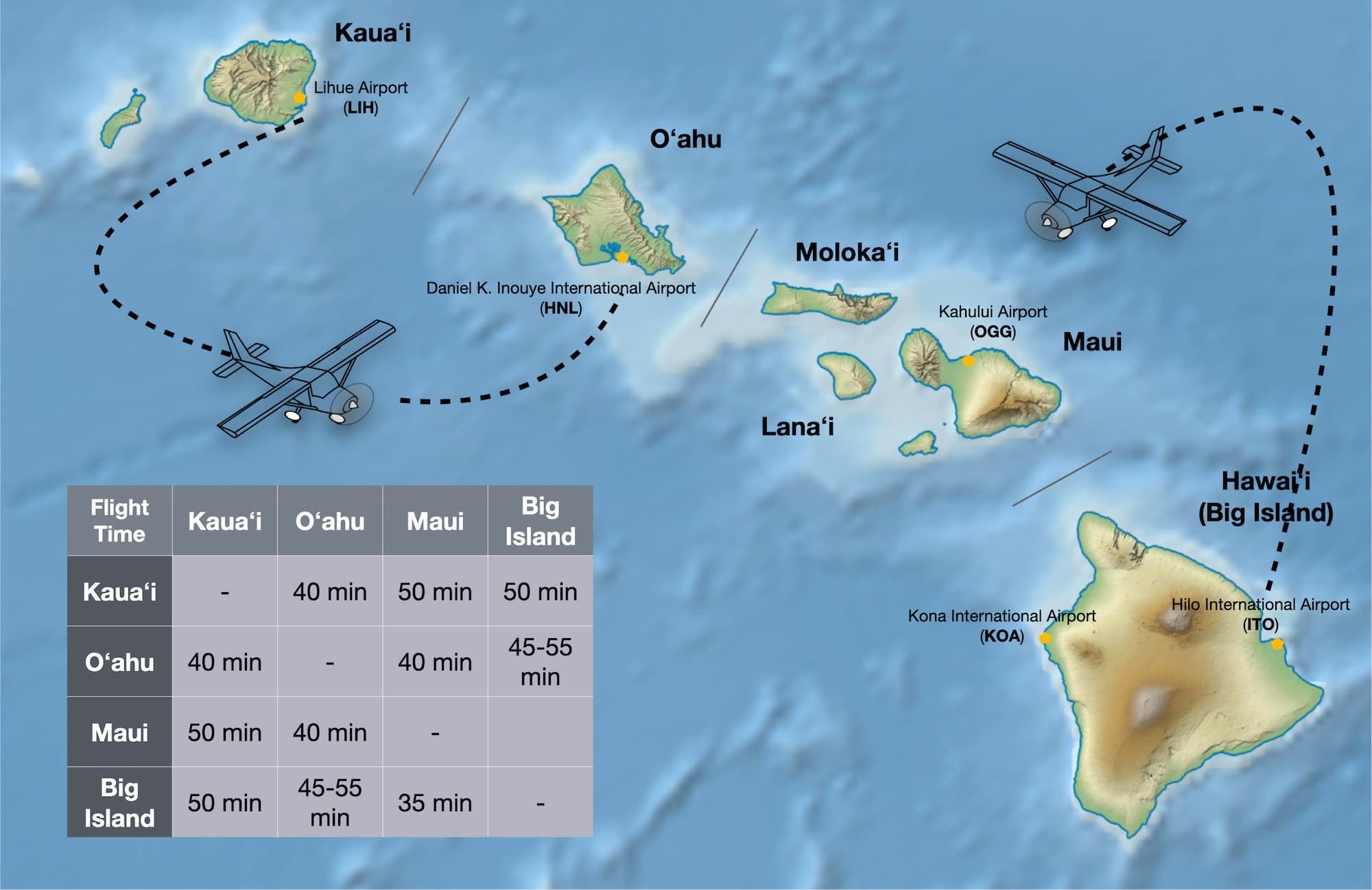
Inter-Island Flights
The primary carrier for inter-island travel is Hawaiian Airlines, which operates a robust schedule of frequent flights between all major islands. In recent years, Southwest Airlines has also entered the market, providing more options and competitive pricing for routes between Honolulu, Kahului, Kona, Hilo, and Lihue.
For those looking to visit the smaller islands, Mokulele Airlines operates smaller Cessna Grand Caravan aircraft. These flights provide a more scenic, low-altitude experience and serve smaller hubs like Kapalua Airport in West Maui, Molokai Airport, and Lanai Airport.
The Ferry Experience
The only remaining inter-island ferry for passengers is the Expeditions Lanai Ferry. This boat runs several times daily between Lahaina Harbor on Maui and Manele Harbor on Lanai. The trip takes about 45 minutes to an hour and covers roughly 9 miles of the Auau Channel. This is a popular choice for day-trippers who want to experience the quiet luxury of Lanai without the hassle of the airport.
Private Charters and Helicopter Tours
For those with a higher budget, private air charters and helicopter tours offer a way to bridge the distance between islands while seeing landmarks like the Na Pali Coast State Wilderness Park or the volcanoes of Hawaii Volcanoes National Park. However, these are generally used for sightseeing rather than practical transportation.
Strategic Planning for Multi-Island Adventures
Knowing the distances helps in deciding how many islands to visit during a single trip. A common mistake is trying to see four islands in ten days. When you factor in the travel time to and from the airport, security checks, and the flight itself, each “island hop” effectively consumes at least half a day of vacation time.
The One-Island Approach
For trips shorter than seven days, most travel experts recommend sticking to one island. Whether you choose the lush landscapes of Kauai or the bustling energy of Waikiki Beach, you will find more than enough attractions to fill your time. For example, on the Big Island, the distance between Kailua-Kona and Hilo is nearly 80 miles by car, meaning even a single island can require significant travel time.
The Two-Island Itinerary
If you have ten to fourteen days, a two-island trip is highly manageable. A popular combination is Oahu and Maui. You can spend a few days visiting the Pearl Harbor National Memorial and hiking Diamond Head State Monument before taking the short 100-mile flight to Maui to drive the Road to Hana and watch the sunrise at Haleakala National Park.
Logistics for the Big Island
Travelers should also consider the size of the Island of Hawaii itself. It is larger than all the other islands combined. Driving from Kona on the west side to see the active lava flows near Kilauea on the east side is a long journey. If your goal is to see the entire island, many people choose to fly into Kona International Airport and fly out of Hilo International Airport to save on backtracking.
Kauai: The Garden Isle
For those traveling to Kauai, the northernmost of the main islands, the distance from the rest of the chain is felt in its serene, “old Hawaii” atmosphere. Visitors here often spend their time at Hanalei Bay or exploring Waimea Canyon State Park, which is often called the “Grand Canyon of the Pacific.” The isolation of Kauai has preserved its rugged beauty, but it also means that adding another island to your trip requires a flight back through the Oahu hub or a direct neighbor-island flight which may be less frequent.

Cultural and Environmental Considerations of Inter-Island Travel
The distance between the islands isn’t just measured in miles; it is also measured in the distinct character and “vibe” of each place. Oahu is the center of commerce and government, home to Iolani Palace and the Polynesian Cultural Center. Molokai, by contrast, has no traffic lights and remains deeply connected to traditional Native Hawaiian culture.
When traveling between islands, it is also important to be mindful of biosecurity. The Hawaii Department of Agriculture requires inspections for all travelers moving between islands to prevent the spread of invasive species, such as the Coconut Rhinoceros Beetle or various fungal diseases like Rapid Ohia Death. These checks are a reminder of how the geographical distance between the islands serves as a natural barrier that helps protect the unique ecosystems found on each one.
Whether you are looking for the luxury resorts of Wailea on Maui, the historic sites of Honolulu, or the volcanic wonders of Mauna Kea, understanding the distances and the logistics of inter-island travel will ensure a smoother, more enjoyable experience in Hawaii. By respecting the geography of the Pacific Ocean and the space between these magnificent landmasses, you can better appreciate the diverse beauty that each island offers.
LifeOutOfTheBox is a participant in the Amazon Services LLC Associates Program, an affiliate advertising program designed to provide a means for sites to earn advertising fees by advertising and linking to Amazon.com. Amazon, the Amazon logo, AmazonSupply, and the AmazonSupply logo are trademarks of Amazon.com, Inc. or its affiliates. As an Amazon Associate we earn affiliate commissions from qualifying purchases.