
The journey from Denver to Las Vegas is one of the most iconic traverses in the United States. It represents a transition from the rugged, alpine majesty of the Rocky Mountains to the shimmering, high-energy spectacle of the Mojave Desert. Whether you are planning a rapid flight for a weekend getaway or a soul-stirring road trip across the American West, understanding the distance and the geography between these two hubs is essential for a successful itinerary.
Calculating the Distance: From Mile High to Neon Lights
When asking “how far,” the answer depends entirely on your mode of transport. The physical distance between Denver, Colorado, and Las Vegas, Nevada, covers a vast expanse of diverse terrain, including mountain passes, high plateaus, and arid basins.

Direct Flight Paths
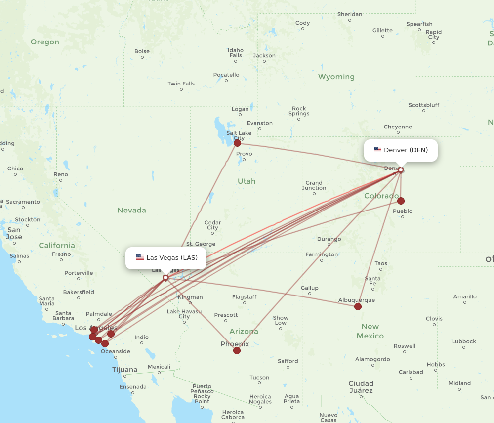
For those looking for the quickest transition, air travel is the most efficient choice. “As the crow flies,” the straight-line distance between the two cities is approximately 600 miles (965 kilometers). Commercial flights departing from Denver International Airport typically land at Harry Reid International Airport in about 1 hour and 45 minutes. This route glides over the heart of the Southern Rockies and the canyon lands of Utah, offering passengers a breathtaking aerial view of the geography that road trippers experience from the ground.
The Odometer: Driving Distances
If you choose to drive, the mileage increases significantly due to the winding nature of mountain highways and the grid of the interstate system. The most direct driving route is roughly 750 miles (1,207 kilometers). Under ideal conditions, this drive takes approximately 11 to 12 hours of pure seat time. However, seasoned travelers know that the stretch of Interstate 70 through Colorado and Interstate 15 through Utah and Arizona is rarely “ideal” when it comes to traffic and weather, making it a journey best spread over two days.
Exploring the Scenic Route via Interstate 70
The most common and arguably most beautiful way to bridge the gap between Denver and Las Vegas is via Interstate 70 West. This highway is a marvel of engineering, cutting through some of the most challenging terrain in North America.
Traversing the Colorado High Country
Immediately upon leaving Denver, the elevation begins to climb. The road ascends into the front range, passing through the Eisenhower Tunnel, which sits at an elevation of over 11,000 feet. Travelers will pass world-renowned ski destinations such as Silverthorne, Vail, and Breckenridge. The scenery here is dominated by evergreen forests and jagged peaks. As you continue west, the landscape shifts dramatically near Glenwood Springs, where the road hugs the walls of the Glenwood Canyon, following the path of the Colorado River.
The Red Rocks of Utah
As you cross the border from Colorado into Utah, the green mountains give way to the “Mighty 5” territory. The earth turns a vibrant shade of burnt orange and deep red. This section of the drive through Grand Junction and into the San Rafael Swell is remote and desolate, yet hauntingly beautiful. The distance between services can be vast, emphasizing the true “wild” nature of the West. After several hundred miles on Interstate 70, the route merges with Interstate 15 South, leading travelers toward the Nevada border.
Essential Sightseeing Stops Along the Journey
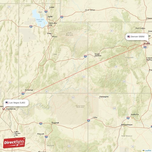
Because the distance is substantial, many travelers transform the “How far from Denver to Las Vegas?” question into an opportunity to explore some of the most famous landmarks in the world.
National Parks and Natural Wonders
The route is a gateway to several National Parks. A short detour south from Crescent Junction leads to Moab, the home of Arches National Park and Canyonlands National Park. These parks offer iconic views of Delicate Arch and the Island in the Sky mesa. Further south on Interstate 15, travelers can access Zion National Park and Bryce Canyon National Park. These stops add mileage to the trip but provide memories that far outweigh the extra time spent behind the wheel.
Charming Mountain Towns and Desert Oases
Aside from the big parks, smaller stops offer local flavor. Fruita is a haven for mountain bikers, while St George serves as a warm, palm-tree-lined precursor to the Nevada climate. Just before reaching Las Vegas, a stop at the Valley of Fire State Park provides a stunning look at red sandstone formations that look almost prehistoric. For those interested in engineering marvels, a slight detour to the Hoover Dam on the border of Nevada and Arizona is a must-see, offering a glimpse of Lake Mead and the sheer power of the Colorado River.
Logistics and Travel Tips for the Denver to Las Vegas Route
Navigating the distance between Denver and Las Vegas requires more than just a GPS. The environmental factors can change rapidly, affecting travel times and safety.
Seasonal Weather Challenges
In the winter, the Rocky Mountains segment of the trip can be treacherous. Heavy snowfall often leads to closures on Interstate 70, particularly at Vail Pass. Travelers should ensure their vehicles are equipped with snow tires or chains and check the Colorado Department of Transportation alerts. Conversely, in the summer, the stretch through Utah and into Las Vegas can see temperatures exceeding 100 degrees Fahrenheit. Overheating is a real risk for older vehicles, and staying hydrated is paramount for everyone on board.
Vehicle Preparation and Fuel Stops
There is a notorious 100-mile stretch of Interstate 70 in Utah between Green River and Salina with no services. No gas stations, no restaurants, and limited cell service. When planning how far you can go on a tank of gas, always top off in Grand Junction or Green River. Additionally, the elevation changes—from 5,280 feet in Denver to over 11,000 feet in the mountains, and then down to 2,000 feet in Las Vegas—can affect tire pressure and engine performance.
Reaching the Destination: Las Vegas and Beyond
As you descend from the Virgin River Gorge into the flat desert floor, the lights of Las Vegas begin to shimmer on the horizon. The transition from the quiet solitude of the Utah desert to the sensory overload of Sin City is one of the most jarring and exciting experiences in American travel.
Navigating the Las Vegas Strip
Once you arrive, the “distance” changes from miles to blocks. The Las Vegas Strip is roughly 4.2 miles long, but walking it can take hours due to the sheer size of the resorts and the crowds. You will find legendary hotels such as The Bellagio, Caesars Palace, and MGM Grand lining the boulevard. Each of these resorts is a destination in its own right, often requiring significant time just to navigate from the parking garage to the lobby.
Nearby Day Trips from Las Vegas
If you haven’t had your fill of the outdoors after the long drive from Denver, Las Vegas serves as a perfect base for further exploration. Red Rock Canyon is just a 20-minute drive from the city center, offering world-class climbing and hiking. For a longer excursion, the Grand Canyon is a few hours away in Arizona, making the journey from the Rockies to the Canyons complete.
The distance from Denver to Las Vegas is more than just a number on a map; it is a passage through the heart of the West. Whether you cover the 750 miles in a single day or spend a week exploring the National Forests and monuments along the way, the journey is just as significant as the destination. By preparing for the terrain, respecting the weather, and planning for the unique logistics of the high desert, you can ensure that your trip from the Mile High City to the world’s entertainment capital is nothing short of spectacular.
LifeOutOfTheBox is a participant in the Amazon Services LLC Associates Program, an affiliate advertising program designed to provide a means for sites to earn advertising fees by advertising and linking to Amazon.com. Amazon, the Amazon logo, AmazonSupply, and the AmazonSupply logo are trademarks of Amazon.com, Inc. or its affiliates. As an Amazon Associate we earn affiliate commissions from qualifying purchases.