
Embarking on a cross-country journey from the sun-kissed Pacific shores of California to the heartland landscapes of Ohio is more than just covering miles; it’s an quintessential American adventure. The vast expanse separating these two distinct states offers a diverse tapestry of geographies, cultures, and experiences, making the question “How far?” a starting point for comprehensive travel planning rather than a simple numerical answer. This extensive journey requires careful consideration of routes, time, and modes of transportation to ensure a seamless and memorable traverse of the United States.
Understanding the Great American Cross-Country Journey
The sheer scale of traveling from the westernmost continental state to the Midwest is impressive. California, a state synonymous with innovation, diverse climates, and iconic cities like Los Angeles and San Francisco, presents a dramatic contrast to Ohio, known for its industrial heritage, agricultural richness, and vibrant metropolitan areas such as Cleveland, Columbus, and Cincinnati. This journey is not merely about distance but about embracing the varying landscapes and discovering the heart of America one mile at a time. The average distance makes it a multi-day undertaking, typically requiring at least three to five days of dedicated driving, depending on the chosen route, stops, and pace.
The Allure of the Open Road
For many, a road trip across the country symbolizes freedom and exploration. The ability to dictate one’s schedule, stop at intriguing roadside attractions, and witness the gradual shift in scenery from arid deserts to towering mountains, and eventually to rolling plains and fertile farmlands, is unparalleled. It’s an opportunity to connect with the diverse fabric of the nation, making the journey itself as significant as the destination. Planning such a trip involves more than just calculating mileage; it encompasses considering the duration, potential overnight stays, and what kind of travel narrative one wishes to create.
Mapping the Miles: Distance and Driving Routes
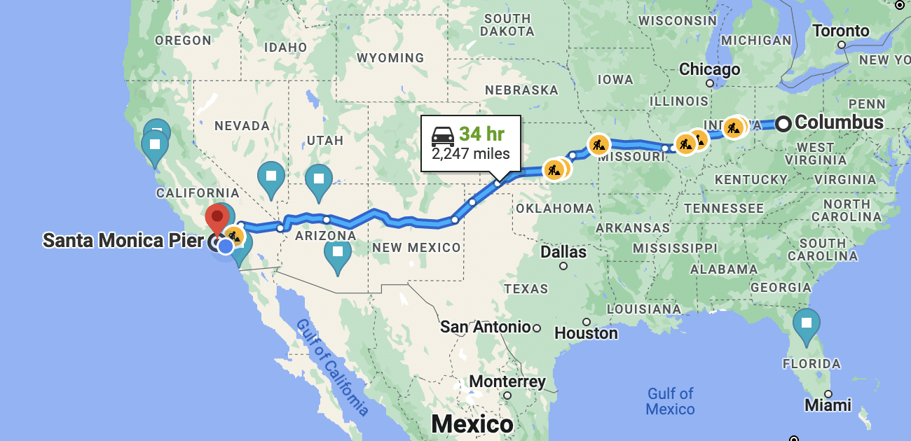
The precise distance from California to Ohio varies significantly depending on the specific starting and ending cities, as well as the chosen route. Generally, the distance ranges from approximately 2,200 miles to over 2,600 miles (about 3,540 km to 4,180 km). The major interstates crisscrossing the country offer several well-traveled paths.
Northern Routes: Traversing the Great Plains
One of the most common routes for those starting in Northern California, such as San Francisco or Sacramento, involves taking Interstate 80 (I-80) eastbound. This route takes travelers through states like Nevada, Utah (passing near Salt Lake City), Wyoming, Nebraska, Iowa, and Illinois before connecting to Interstate 90 (I-90) or Interstate 70 (I-70) to reach Ohio. This path covers approximately 2,400 to 2,500 miles, depending on the exact destination in Ohio, and is largely characterized by relatively flat terrain once past the Rocky Mountains.
Central Routes: The Artery of America
For departures from Central or Southern California, like Los Angeles or San Bernardino, Interstate 70 (I-70) is often the preferred choice. After traversing Nevada and Utah, this route continues through Colorado (passing through Denver), Kansas (connecting through Kansas City), Missouri (near St. Louis), Illinois, and Indiana directly into Ohio. This route is typically around 2,200 to 2,350 miles and offers a more direct east-west trajectory, featuring diverse landscapes from mountainous regions to the vast agricultural plains.
Southern Routes: A Warm Weather Alternative
A southern alternative, particularly appealing during winter months or for those seeking a warmer climate, involves using Interstate 40 (I-40). Starting from Southern California, this route cuts through Arizona (passing by Phoenix or Flagstaff), New Mexico (through Albuquerque), Texas, Oklahoma (near Oklahoma City), Arkansas, and Tennessee, eventually connecting northward via other interstates (Interstate 57 to Interstate 70, or Interstate 65 to Interstate 70) into Ohio. This route can be longer, potentially ranging from 2,500 to 2,700 miles, but offers different scenic vistas and cultural experiences along the way.
Beyond the Miles: Time and Logistical Considerations
Understanding the distance is only the first step. The actual time commitment and logistical planning are crucial for a successful cross-country journey.

Calculating Driving Time
Pure driving time for a 2,200-mile trip, maintaining an average speed of 65 mph (including short stops for gas and quick breaks), would be approximately 34-38 hours. However, this is a theoretical number. Realistic daily driving limits for most individuals or families typically range from 8 to 10 hours. Pushing beyond this can lead to fatigue, reducing safety and enjoyment. Therefore, a journey of this magnitude necessitates multiple days of travel.
Recommended Stopovers and Overnight Stays
To maintain safety and comfort, breaking the trip into manageable segments is essential. For a 2,200-mile journey, a good rule of thumb is to plan for at least three full days of driving, with two overnight stays. This allows for about 700-750 miles per day, which is a considerable but achievable distance.
- Day 1: From California to central Colorado or western Kansas (e.g., Denver or Goodland, KS).
- Day 2: From Colorado or Kansas to central Illinois or western Indiana (e.g., St. Louis, MO, or Indianapolis, IN).
- Day 3: From Illinois or Indiana to Ohio.
For a more relaxed pace, particularly if traveling with children or wanting to explore more, a four-day trip with three overnight stops would allow for approximately 550-600 miles per day, making for a more enjoyable and less rushed experience. Major cities along the routes like Las Vegas, Salt Lake City, Denver, Kansas City, St. Louis, and Indianapolis offer ample choices for lodging and dining.
Fueling Your Journey
Fuel costs represent a significant portion of the travel budget for a cross-country drive. Prices per gallon can fluctuate significantly from state to state and even within different regions of the same state. It’s advisable to monitor gas prices using apps or online resources and refuel strategically, especially when passing through areas known for higher fuel costs. Planning regular stops not just for gas but also for stretching and rest is crucial for driver alertness and passenger comfort.
Alternative Modes of Transport: Flying and Rail
While a road trip offers unique advantages, other transportation options exist for those prioritizing speed or a different travel experience.
Air Travel: Speed and Convenience
For sheer speed, flying is undoubtedly the quickest way to cover the distance between California and Ohio. Direct flights from major California airports (like Los Angeles International Airport or San Francisco International Airport) to major Ohio airports (such as Cleveland Hopkins International Airport or John Glenn Columbus International Airport) can range from 4.5 to 6 hours. Factoring in travel to and from airports, security, and potential layovers, the total travel time typically amounts to 8-12 hours. This option is ideal for those with limited time or who prefer to avoid long hours behind the wheel.
Rail Travel: A Scenic Alternative
Amtrak offers cross-country rail services that provide a unique and relaxed way to travel. While slower than driving or flying, often taking two to three days, it allows travelers to enjoy the scenery without the stress of driving. Routes like the California Zephyr (from San Francisco Bay Area to Chicago) or the Southwest Chief (from Los Angeles to Chicago) connect California to Chicago, from where connections can be made to Ohio cities. This mode of transport appeals to those seeking a leisurely pace, comfort, and the opportunity to view the diverse American landscape from a different perspective.

Embracing the Journey: Highlights Along the Way
A cross-country trip is an experience in itself, offering countless opportunities for exploration. Depending on the chosen route, travelers can encounter iconic landmarks and natural wonders that enrich the journey.
Along the central I-70 corridor, one might encounter the majestic Rocky Mountains in Colorado, the vast plains of Kansas, and the impressive Gateway Arch in St. Louis, Missouri. The I-80 route offers views of the Great Salt Lake in Utah and the historic trails of Nebraska and Iowa. Opting for the southern I-40 route could mean marveling at the Grand Canyon in Arizona or exploring the vibrant culture of Santa Fe, New Mexico.
Each route presents its own unique set of attractions and experiences, turning a simple point-to-point transit into an unforgettable journey through the heart of America. The key is to plan not just for the destination but for the incredible vistas and cultural touchpoints that lie between California and Ohio.
LifeOutOfTheBox is a participant in the Amazon Services LLC Associates Program, an affiliate advertising program designed to provide a means for sites to earn advertising fees by advertising and linking to Amazon.com. Amazon, the Amazon logo, AmazonSupply, and the AmazonSupply logo are trademarks of Amazon.com, Inc. or its affiliates. As an Amazon Associate we earn affiliate commissions from qualifying purchases.